Showing 2318 items matching " infrastructure"
-
 Kiewa Valley Historical Society
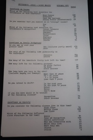
Papers - Settlement Study - Mount Beauty 1971 x5, October 1971
Similar to a census for Mount Beauty in October 1971. Topics include Income, family, the town, society and travel outside the town.The results of the survey give an insight into the community of Mt Beauty after the SEC days, the infrastructure available and the activities of the population living in the town. This would also enable a comparison to be made before or after 1971.Typed papers on the Settlement Study results in Mt Beauty Oct. 1971. Each page gives the question asked and the number of people responding in each given area. The papers are dated October 1971.mt beauty, census 1971, statistics -
 Kiewa Valley Historical Society
Booklet - Victoria's Hydro Power x2, Victoria's Hydro Power - SEC, August 1975
The State Electricity Commission of Victoria built several hydro power stations from 1928-1981. This book names each - up to 1975 - with a summary and explanation.The State Electricity Commission of Victoria built the Kiewa Hydro Electric Scheme which included the construction of Bogong Power Station, McKay Creek Power Station and West Kiewa Power Station. It also established infrastructure such as the townships of Bogong and Mt Beauty and the opportunity for tourism in the area Colored green/blue 'splash' of water on front cover with SEC logo in white centred under the yellow printed title. On the back cover is the SEC logo at the bottom in the middle.state electricity commission of victoria; kiewa hydro electric scheme; mckay creek power station; clover power station; west kiewa power station -
 Kiewa Valley Historical Society
Papers - Observation Walk on the Bogong High Plains. x5
Students study the Bogong High Plains noting geology, history, vegetation and evolution / changes.Environmental studies includes the effect of people, horses, skiing, infrastructure etc.Typed and hand written notes on the Bogong High Plains for students observing the vegetation. It includes geology and early history.bogong high plains, grazing, vegetation -
 Kiewa Valley Historical Society
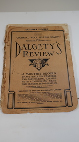
Book - Farming - Pastoral & Agricultural, Dalgety's Review 1906-1907
Dalgety's is a stock and station agent who produced a 'monthly record / of Australian Pastoral / and Agricultural Affairs / with Commercial news / and General information.' 1906 was the 14th year of publication.The Kiewa Valley consisted only of farming until the late 1940s when the Kiewa Hydro Electric Scheme commenced in the Upper Kiewa Valley creating the townships of Bogong and Mt Beauty and the corresponding infrastructure. This book would have been subscribed to (9pence) by local farmers all the way along the valley.Paper cover with black print and sketch of a sheep's head with horns in the centre. It has 140 pages which include black & white print of articles, advertisements, charts and photos.dalgety's review 1906, kiewa valley farmers, stock and station agent -
 Kiewa Valley Historical Society
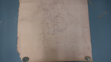
Map - Bogong High Plains
Bogong high Plains showing mountains, places, roads and riversHistorical changes of infrastructure on the Bogong High PlainsBogong High Plains, hand written and 'copied with considerable simplification from F.C.V. (Falls Creek V.?) 'Feathetop' L 'Tawonga'. Paper is yellowed, writing is brown.bogong high plains map -
 Kiewa Valley Historical Society
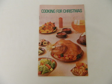
Booklet - S.E.C.V, Cooking for Christmas
The State Electricity Commission of Victoria's Home Advisory Service prepared this collection of recipes. They also assisted with advice and information on the best use of electricity in the home. The S.E.C. sold electrical appliances at their showrooms, one of which was located in Mt Beauty where this booklet came from.The S.E.C.V. constructed the Kiewa Hydro Electric Scheme employing many workers. They built the townships of Bogong and Mt Beauty and assisted with the infrastructure required to support the influx of population. In the Mt Beauty shopping centre, one of the shops was the S.E.C. Showroom which sold electrical appliances and gave advice on their use along with recipe booklets for cooking on the new electrical appliances.Small 12 page booklet with soft cover and two staples binding it. Cover has coloured photos of plates of food with the title in green at the top.recipes. christmas. state electricity commission of victoria. sec home advisory service. electrical appliances. -
 Kiewa Valley Historical Society
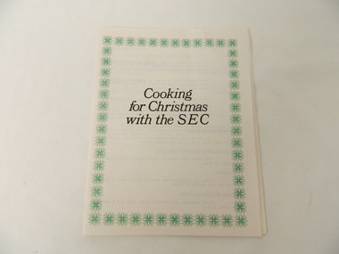
Booklet - S.E.C.V, Cooking for Christmas with the SEC
For many years, the State Electricity Commission of Victoria produced a Christmas Recipe booklet. This one has been typed up without the glossy quality of others that were issued from the Sales Department of the S.E.C.V..The SECV constructed the Kiewa Hydro Electric Scheme employing many workers. They built the townships of Bogong and Mt Beauty and assisted with the infrastructure required to support the influx of population. In the Mt Beauty shopping centre, one of the shops was the SEC Showroom which sold electrical appliances and gave advice on their use along with recipe booklets for cooking on the new electrical appliances. This booklet continues the tradition of a Christmas recipe booklet.White 22 page booklet with the black title in the middle of the cover surrounded by a repeated-design green border. recipes. secv. christmas recipes. -
 Kiewa Valley Historical Society
Booklet - S.E.C.V, How to Prepare & Store Frozen Food
The SECV's Home Advisory Service prepared this book to advise customers on the use of home freezers.They also assisted with advice and information on other electrical appliances. The SEC had Showrooms in regional Victoria including one at Mt Beauty where this booklet came from.The S.E.C.V. constructed the Kiewa Hydro Electric Scheme employing many workers. They built the townships of Mt Beauty and Bogong and assisted with the infrastructure required to support the influx of population. In the Mt Beauty shopping centre, one of the shops was the SEC Showroom which sold electrical appliances and gave advice on their use. This book gives advise on the use of freezers.Booklet with 22 pages held together with two staples. The cover has an orange and then blue title at the top and below, a coloured picture of fruit and vegetables. state electricity commission of victoria. food. freezer. cooking. electrical appliance. -
 Kiewa Valley Historical Society
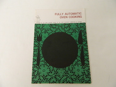
Booklet - S.E.C.V, Fully Automatic Oven Cooking
The SECV's Home Advisory Service prepared this booklet to advise & inform women on the use of cooking with a fully automatic oven. The SECV sold electrical appliances at their showrooms throughout regional Victoria, one of which was located in Mt Beauty.The SECV constructed the Kiewa Hydro Electric Scheme employing many workers. They built the townships of Bogong and Mt Beauty and assisted with the infrastructure required to support the influx of population. In the Mt Beauty shopping centre, one of the shops was the SEC Showroom which sold electrical appliances and gave advice on their use. This booklet gives advice and information on automatic ovens. Green, black and white 12 page booklet with a cardboard cover and held together with 2 staples. The brown title is at the top of the cover and below, in black, a plate, knife and fork with a green and black lace background.Cover: Prepared by the Home Advisory Service of the State Electricity Commission of Victoriaautomatic oven. state electricity commission of victoria. cooking. electrical appliances. -
 Kiewa Valley Historical Society
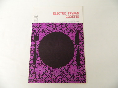
Booklet - S.E.C.V, Electric Frypan Cooking
The State Electricity Commission of Victoria's Home Advisory Service prepared this booklet to advise and inform women on the use of cooking with an electric frying pan. The SECV sold electrical appliances at their showrooms throughout regional Victoria, one of which was located at Mt Beauty.The SECV constructed the Kiewa Hydro Electric Scheme employing many workers. They built the township of Bogong and Mt Beauty and assisted with the infrastructure to support the influx of population. In the Mt Beauty shopping centre, one of the shops was the SEC Showroom which sold electrical appliances and gave advice on their uses. This booklet gives advice and information on electric frypans.Purple, black and white 16 page booklet with a cardboard cover and held together with 2 staples. The red title is at the top of the cover and below, in black, a plate, knife and fork with a purple and black lace background.Cover: Prepared by the Home Advisory Service of the SECV.state electricity commission of victoria. cooking. electrical appliance. food. electric frypan. -
 Kiewa Valley Historical Society
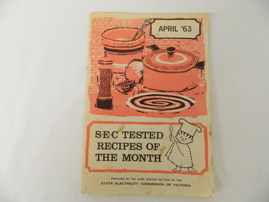
Book - S.E.C.V, S.E.C. Tested Recipes of the Month. April '63, April 1963
The S.E.C.V.'s Home Service Section prepared this book to encourage women to cook with electricity especially with the later appliances. Part of their advertising suggested that they go to their electricity showroom for advice on purchasing a new appliance. The S.E.C. had showrooms in regional Victoria including one at Mt Beauty.The SECV constructed the Kiewa Hydro Electric Scheme employing many workers. They built the townships of Bogong and Mt Beauty and assisted with the infrastructure required to support the influx of population. In the Mt Beauty shopping centre, one of the shops was the S.E.C. Showroom, which sold electrical appliances and gave advice on their use and the latest models available. This book is a promotion to encourage women to cook using the latest electrical appliances.The cover is white, black and pinkish book showing a sketch of the top of a stove in the top half and below, the title with a cartoon chef. Along the bottom of the cover "Prepared by the Home Service Section of the / State Electricity Commission of Victoria. The book has 20 pages held by two staples. The book consists of recipes but has some electricity advertising in it as does the back cover.secv. recipes. cooking. electricity. electrical appliances. -
 Warrnambool and District Historical Society Inc.
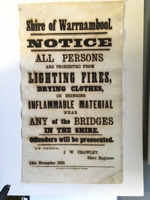
Document, Shire of Warrnambool Fire - Washing-Bridge 1882, 1882
This notice relates to the prohibition of lighting fires,drying clothes or bringing inflamable material near any of the bridges in the shire. Offenders will be prosecuted. With a date of 1882 and the fact that bridges were mostly made of wood, it would have been of concern that the destruction of bridges was not only of great inconvenience but also of considerable expense. But the reality of bridges providing shelter and warmth in the colder months and the ensuring fires and burnt bridges has more than likely precipitated this notice. J W Crawley was shire engineer from 1876 until 1895 and for 10 of those years he trained his son J W Crawley who succeeded his father and served in the position for 40 years.He in turn was succeeded by his son Rolf Crawley in 1935. In 1963 the bridge over the Hopkins Falls at Wangoom was named the Crawley bridge in honour of service to the Shire of Warrnambool by members of the Crawley family. The Shire of Warrnambool was proclaimed in 1863 and covered an area of over 600 square miles. Much of it was incorporated into the Moyne Shire in the 1990's with some being included into the boundaries of City of Warrnambool. This banner is an interesting piece of history. It shows the issues confronting early settlers such as shelter and the chores of daily life but also the importance placed on infrastructure which was slowly taking place around the district. It was in the era of drainage and roadworks and hence bridges were an important part of that infrastructure. The name J W Crawley is one of importance in the Warrnambool district for his service over many years. Rectangular piece of cloth printed in black ink. The back is plain.Shire of Warrnambool By order of J W Crawley Shire Engineer, 13th November 1882. Thos Smith gas Printing Works Koroit Street Warrnambool.warrnambool, shire of warrnambool, bridges of warrnambool shire, j w crawley, warrnambool shire engineer, crawleys of warrnambool -
 Eltham District Historical Society Inc
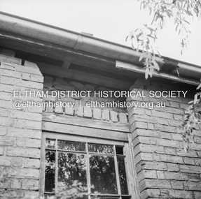
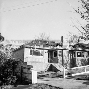
Negative - Photograph, J.A. McDonald, Old house, Susan Street, Eltham, c. 1962
Williams house, Susan StreetRecord of various Shire of Eltham infrastructure works undertaken during the period of 1952-1962 involving bridge and road reconstruction projects, sometimes with Eltham Shire Council Project Reference numbers quoted. It was during this period that a number of significant improvements were made to roads and new bridges constructed within the shire that remain in place as of present day (2022). In many situations, the photos provide a tangible visible record of infrastructure that existed throughout the early days of the Shire. The album was put together by or under the direction of the Shire Engineer, J.A. McDonald.eltham, houses, susan street, williams house -
 Eltham District Historical Society Inc
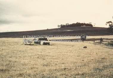
Album - Photograph, J.A. McDonald, Garden Hill, Kangaroo Ground, c. 1962
Garden Hill burnt following bush fires - most likely the 15-16 Jan 1962 fire A helicopter can be seen flying over the top of the hill Eltham Shire Council purchased this property in the early 1970s and it has now been incorpoarted within the Shire of Eltham Memorial ParkRecord of various Shire of Eltham infrastructure works undertaken during the period of 1952-1962 involving bridge and road reconstruction projects, sometimes with Eltham Shire Council Project Reference numbers quoted. It was during this period that a number of significant improvements were made to roads and new bridges constructed within the shire that remain in place as of present day (2022). In many situations, the photos provide a tangible visible record of infrastructure that existed throughout the early days of the Shire. The album was put together by or under the direction of the Shire Engineer, J.A. McDonald.1962, garden hill, kangaroo ground, shire of eltham memorial park, victorian bushfires - 1962 -
 Eltham District Historical Society Inc
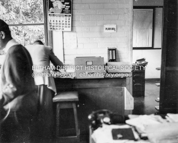
Album - Photograph, J.A. McDonald, Garden Hill, Kangaroo Ground, Feb. 1963
Most likley the interior of the Eltham Shire Offices at the corner of Artur Street and Main Road. The calendar is set on February 1963. ERngineering and Planning were also loacted in the shop fronts located next door on Main Road.Record of various Shire of Eltham infrastructure works undertaken during the period of 1952-1962 involving bridge and road reconstruction projects, sometimes with Eltham Shire Council Project Reference numbers quoted. It was during this period that a number of significant improvements were made to roads and new bridges constructed within the shire that remain in place as of present day (2022). In many situations, the photos provide a tangible visible record of infrastructure that existed throughout the early days of the Shire. The album was put together by or under the direction of the Shire Engineer, J.A. McDonald.arthur street, eltham, eltham shire office, main road, 1963-02 -
 Eltham District Historical Society Inc
Negative - Photograph, J.A. McDonald, Newly built home, Sep. 1955
Street and location unidentified, possibly not Eltham though next immediate frame is Pryor Street and sun position appears to be similar indicating street (ealrly to mid afternoon) indicating street runs east west direction and camera view is to the south. Streets in Eltham are all even numbered on the south sideRecord of various Shire of Eltham infrastructure works undertaken during the period of 1952-1962 involving bridge and road reconstruction projects, sometimes with Eltham Shire Council Project Reference numbers quoted. It was during this period that a number of significant improvements were made to roads and new bridges constructed within the shire that remain in place as of present day (2022). In many situations, the photos provide a tangible visible record of infrastructure that existed throughout the early days of the Shire. The album was put together by or under the direction of the Shire Engineer, J.A. McDonald.1955-09, houses, shire of eltham -
 Eltham District Historical Society Inc
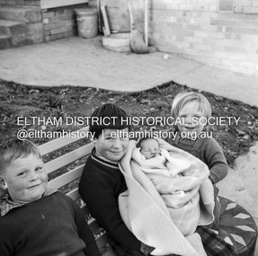
Negative - Photograph, J.A. McDonald, Unidentified children, Sep. 1959
Believed to be four children all of the same family, most probably those of an Eltham Shire Council employee who worked for the Engineering department (see image 05584-8)Record of various Shire of Eltham infrastructure works undertaken during the period of 1952-1962 involving bridge and road reconstruction projects, sometimes with Eltham Shire Council Project Reference numbers quoted. It was during this period that a number of significant improvements were made to roads and new bridges constructed within the shire that remain in place as of present day (2022). In many situations, the photos provide a tangible visible record of infrastructure that existed throughout the early days of the Shire. The album was put together by or under the direction of the Shire Engineer, J.A. McDonald.shire of eltham, 1959-09, children -
 Eltham District Historical Society Inc
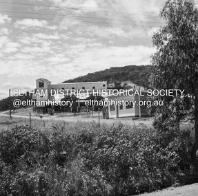
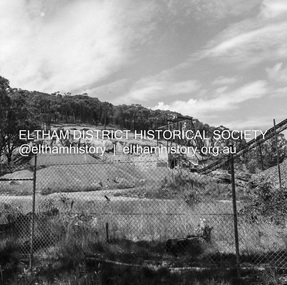
Negative - Photograph, J.A. McDonald, Unidentified quarry, Jan. 1961
Record of various Shire of Eltham infrastructure works undertaken during the period of 1952-1962 involving bridge and road reconstruction projects, sometimes with Eltham Shire Council Project Reference numbers quoted. It was during this period that a number of significant improvements were made to roads and new bridges constructed within the shire that remain in place as of present day (2022). In many situations, the photos provide a tangible visible record of infrastructure that existed throughout the early days of the Shire. The album was put together by or under the direction of the Shire Engineer, J.A. McDonald.1961-01, quarry -
 Eltham District Historical Society Inc
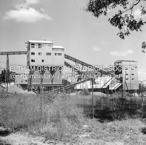
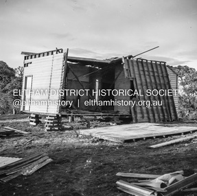
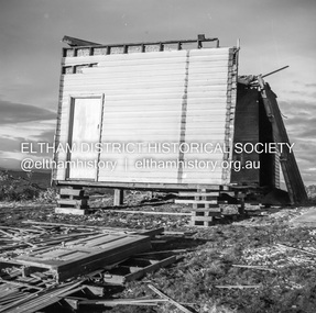
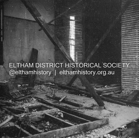
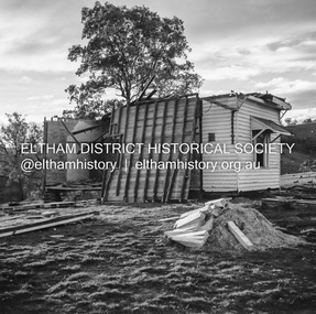
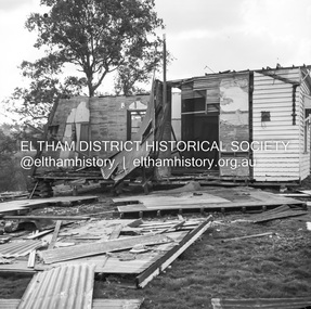
Negative - Photograph, J.A. McDonald, Inspection of storm damaged Abraham house at Kangaroo Ground, c. May 1962
Showing the effect of a wind storm that destroyed the house circa May 1962.. The Abraham family owned land near the Aqueduct and east of Nicholas Lane at Kangaroo Ground (based on photos, at or near 40 Nicholas Lane).Record of various Shire of Eltham infrastructure works undertaken during the period of 1952-1962 involving bridge and road reconstruction projects, sometimes with Eltham Shire Council Project Reference numbers quoted. It was during this period that a number of significant improvements were made to roads and new bridges constructed within the shire that remain in place as of present day (2022). In many situations, the photos provide a tangible visible record of infrastructure that existed throughout the early days of the Shire. The album was put together by or under the direction of the Shire Engineer, J.A. McDonald.1962-05, abraham house, kangaroo ground, nicholas lane, property damage, storm damage -
 Eltham District Historical Society Inc
Negative - Photograph, J.A. McDonald, Inspection of storm damaged Abraham house at Kangaroo Ground, c. May 1962
Showing the effect of a wind storm that destroyed the house circa May 1962.. The Abraham family owned land near the Aqueduct and east of Nicholas Lane at Kangaroo Ground (based on photos, at or near 40 Nicholas Lane).Record of various Shire of Eltham infrastructure works undertaken during the period of 1952-1962 involving bridge and road reconstruction projects, sometimes with Eltham Shire Council Project Reference numbers quoted. It was during this period that a number of significant improvements were made to roads and new bridges constructed within the shire that remain in place as of present day (2022). In many situations, the photos provide a tangible visible record of infrastructure that existed throughout the early days of the Shire. The album was put together by or under the direction of the Shire Engineer, J.A. McDonald.1962-05, abraham house, kangaroo ground, nicholas lane, property damage, storm damage, building surveyor, george e. newton -
 Eltham District Historical Society Inc
Negative - Photograph, J.A. McDonald, Inspection of storm damaged Abraham house at Kangaroo Ground, c. May 1962
Showing the effect of a wind storm that destroyed the house circa May 1962.. The Abraham family owned land near the Aqueduct and east of Nicholas Lane at Kangaroo Ground (based on photos, at or near 40 Nicholas Lane).Record of various Shire of Eltham infrastructure works undertaken during the period of 1952-1962 involving bridge and road reconstruction projects, sometimes with Eltham Shire Council Project Reference numbers quoted. It was during this period that a number of significant improvements were made to roads and new bridges constructed within the shire that remain in place as of present day (2022). In many situations, the photos provide a tangible visible record of infrastructure that existed throughout the early days of the Shire. The album was put together by or under the direction of the Shire Engineer, J.A. McDonald.1962-05, abraham house, kangaroo ground, nicholas lane, property damage, storm damage -
 Eltham District Historical Society Inc
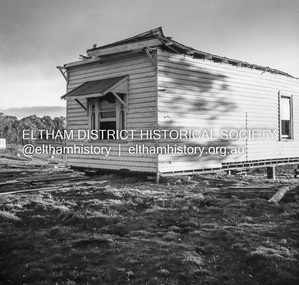
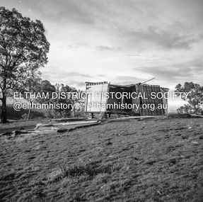
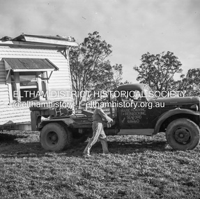
Negative - Photograph, J.A. McDonald, Removal of the remains of the Abraham house at Kangaroo Ground, c. May 1962
Martin Bros House Removing of Seaford was contracted to remove the remains of the storm damaged Abraham house from the property circa May 1962. The Abraham family owned land near the Aqueduct and east of Nicholas Lane at Kangaroo Ground (based on photos, at or near 40 Nicholas Lane).Record of various Shire of Eltham infrastructure works undertaken during the period of 1952-1962 involving bridge and road reconstruction projects, sometimes with Eltham Shire Council Project Reference numbers quoted. It was during this period that a number of significant improvements were made to roads and new bridges constructed within the shire that remain in place as of present day (2022). In many situations, the photos provide a tangible visible record of infrastructure that existed throughout the early days of the Shire. The album was put together by or under the direction of the Shire Engineer, J.A. McDonald.1962-05, abraham house, kangaroo ground, martin bros house removing seaford, nicholas lane, property damage -
 Eltham District Historical Society Inc
Negative - Photograph, J.A. McDonald, Removal of the remains of the Abraham house at Kangaroo Ground, c. May 1962
Martin Bros House Removing of Seaford was contracted to remove the remains of the storm damaged Abraham house from the property circa May 1962. The Abraham family owned land near the Aqueduct and east of Nicholas Lane at Kangaroo Ground (based on photos, at or near 40 Nicholas Lane).Record of various Shire of Eltham infrastructure works undertaken during the period of 1952-1962 involving bridge and road reconstruction projects, sometimes with Eltham Shire Council Project Reference numbers quoted. It was during this period that a number of significant improvements were made to roads and new bridges constructed within the shire that remain in place as of present day (2022). In many situations, the photos provide a tangible visible record of infrastructure that existed throughout the early days of the Shire. The album was put together by or under the direction of the Shire Engineer, J.A. McDonald.1962-05, abraham house, kangaroo ground, martin bros house removing seaford, nicholas lane, property damage