Showing 2930 items
matching a campbell
-
 Orbost & District Historical Society
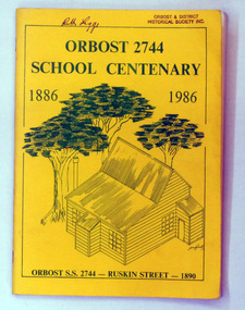
book, Orbost 2744 School Centenary 1886 1986, 1986
2228.1 belonged to Ruth Legge. 2228.2 belonged to Mary Gilbert. This book was produced as a souvenir history of Orbost Primary School. The Orbost State School opened on 19th of March 1886 .The school had first operated temporarily in a leased building, and on a half-time basis with SS2745 Jarrahmond. The first head teacher was HT Campbell Mackay. However he remained in charge only until 12th of May 1886. The second HT, John Rowe, served until 1908. On 30th of June 1887, a portable room was provided; it being brought to the area by schooner. The school then had accommodation for 30 pupils; the teacher's welfare was considered because quarters of two rooms were attached. As the population increased so did the needs of the school. This was reflected in the provision of a larger classroom in 1898. During 1910-11 the first approaches were made to the Department for the establishment of a HES in Orbost and this became a reality in 1912. Orbost HES supplied post-primary education in the district until a high school was built in 1948. When fire destroyed the school in 1941 local halls were used as classrooms until a new school was built. Work was quite rapid and a new brick structure was opened by the Hon. A. E. Lind, MLA, on 13th of February 1942. The head teacher then was Leslie Collins. Orbost continued to develop and the new school was soon overtaxed. This resulted in the erection of two Bristol classrooms in 1947. By 1950, when the school population had reached 500 pupils the opening of the new school at Orbost North was welcomed by all concerned. In 1963 the Department purchased land diagonally opposite the school and developed it as a playing area. In 1965 two LTCs were opened in November, and in October 1968 the Brodribb School building was moved to SS2744 Orbost for use as a general purpose room. This book is a useful research resource.Two copies of a yellow paper book book. On the front cover is a sketch of some trees beneath the title which is in green print ( these are the school colours) . This is a souvenir record of the history of Orbost Primary School.2228.1 has autographs on the back fly.orbost-primary-school book orbost-history -
 Flagstaff Hill Maritime Museum and Village
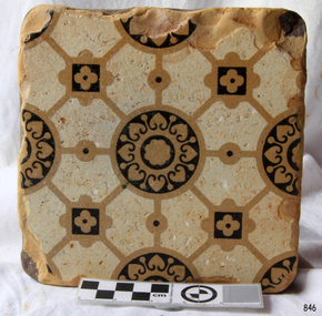
Ceramic - Tile, circa 1878
This Minton floor tile is from the wreck of the LOCH ARD. Other examples of this manufacture have been recovered from the wreck site and form part of the collection at Flagstaff Hill. The iron-hulled clipper ship from the Loch Line was heading for Port Phillip from London when it ran into the cliffs of Mutton Bird Island near Port Campbell and was wrecked on the early morning of June 1, 1878. The LOCH ARD was laden with high-value cargo including luxury goods intended for display at the Melbourne International Exhibition in 1880. One notable survivor from the ship’s freight manifest was the well-packed Minton porcelain peacock, a two-metre-high ceramic masterpiece of vivid glazed colours. The almost total loss of life and property from the LOCH ARD registered as a shocking tragedy for the Colony of Victoria, at a time when social confidence and economic optimism were otherwise high. The wealth generated from gold and wool was increasingly being spent on magnificent private residences and imposing public buildings. The demand for quality furnishings and fittings was therefore strong. Among the products consigned to burgeoning colonial markets by the Milton Pottery at Stoke upon Trent were their new range of colourfully patterned but very durable floor tiles – ideal for the high-traffic spaces in the large civic buildings then being constructed in Australia and America. These new floor tiles were “encaustic”, meaning that their designs and colours were encased within the depth of the tile. Rather than their decorative patterns being glazed onto the surface of the tile, their inlaid designs were created during the manufacturing process, as “coloured slips” (or liquid clay) that were poured into a deep pre-moulded casting. When fired, the resulting tile was colour-fast and design-fast.The Minton encaustic floor tile is significant for its method of manufacture which makes it durable as well as decorative. The shipwreck of the LOCH ARD is of State significance. Victorian Heritage Register S417. Flagstaff Hill’s collection of artefacts from LOCH ARD is significant for being one of the largest collections of artefacts from this shipwreck in Victoria. It is significant for its association with the shipwreck, which is on the Victorian Heritage Register (VHR S417). The collection is significant because of the relationship between the objects, as together they have a high potential to interpret the story of the LOCH ARD. The LOCH ARD collection is archaeologically significant as the remains of a large international passenger and cargo ship. The LOCH ARD collection is historically significant for representing aspects of Victoria’s shipping history and its potential to interpret sub-theme 1.5 of Victoria’s Framework of Historical Themes (living with natural processes). The collection is also historically significant for its association with the LOCH ARD, which was one of the worst and best-known shipwrecks in Victoria’s history.A square Minton floor tile with a black and beige pattern against a white base. This encaustic floor tile was recovered from the shipwreck of the LOCH ARD. On the back, or base, of the tile is inscribed the number “46” and the letters “Minton & Co Patent Stoke upon Trent”.flagstaff hill, warrnambool, shipwrecked coast, flagstaff hill maritime museum, maritime museum, shipwreck coast, flagstaff hill maritime village, great ocean road, loch line, loch ard, mutton bird island, loch ard gorge, minton floor tile, encaustic tile, melbourne international exhibition, floor tile -
 Flagstaff Hill Maritime Museum and Village
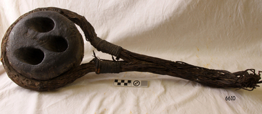
Deadeye, circa 1873
This example of a sailing ship’s ‘dead-eye’ is from the wreck of the LOCH ARD, which sank near Port Campbell in 1878. The vessel was an iron hulled clipper ship constructed for the Loch Line in 1873. It was part of a fleet of similar merchant ships owned by that company, which specialised in bringing passengers and goods from London via the Great Circle route to Melbourne, and returning to Britain via Cape Horn with the colony’s wool clip. Deadeyes were a common feature of sailing ship technology in the nineteenth century. They were a simple, cheap, and hard-wearing device that, in conjunction with another deadeye, provided an effective means of levering, or tightening, attached ropes and stays. Lower deadeyes were fixed to the sides of the ship by an encircling metal collar (inset in a flattish groove chiselled around the outer circumference of the disc), which was bolted to iron bars attached to the hull (called chain-plates). Upper deadeyes were looped by a strong hemp or wire rope (inset in a rounded groove carved around the outer circumference of the disc), which was joined to the bottom ends of the rigging which reached up to secure the masts into position (called shrouds or stays). Connecting a Lower deadeye to its corresponding Upper deadeye was a rope (called a lanyard) which looped up and down through the three “eyes” of each disc, to form a pulley system. The hitching of the two deadeyes with a looped lanyard provided the means of tightening, or loosening, the tension on the mast rigging ― essentially by pulling against the chain-plates bolted to the outside of the hull. It was a procedure that could be performed by sailors at sea and in emergencies. For example, after a gale the stays may have stretched and the masts worked loose, requiring retightening. Or, in the extreme circumstance of shipwreck, the lanyards might need to be released on the weather side, so that the masts fall away from the stricken vessel. The shipwreck of the LOCH ARD is of State significance. Victorian Heritage Register S417.A well-preserved ship’s deadeye with wire loop rope still attached. The original tar coating for water-proofing still remains, colouring the entire artefact black. It is wrapped in hessian cloth and hemp cord and is currently in storage under secure and stable conditions. This deadeye was recovered from the wreck of the LOCH ARD. The artefact is a typical deadeye, comprising a thick round wooden disc, pierced by 3 similarly sized and shaped holes from one flat side through to the other, in a triangle formation. The survival of the wire cable loop-rope suggests it was an Upper Deadeye, connected to the shrouds (mast rigging). Previous number PWO 2388.flagstaff hill, warrnambool, shipwrecked-coast, flagstaff-hill, flagstaff-hill-maritime-museum, maritime-museum, shipwreck-coast, flagstaff-hill-maritime-village, deadeye, loch ard, rigging -
 Flagstaff Hill Maritime Museum and Village
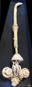
Functional object - Light Fitting, c. 1878
This light hanging mechanism could have been used for an adjustable chandelier with candle holders. It would likely be attached to the ceiling by its long stem to suspend the light fitting. A chain would have been threaded around each pulley, with one end joined to the top of the light fitting and the other end joined to a counter weight. The four counter weights would allow the light fitting to be raised or lowered to the desired height with little effort, to allow for lighting the candles or change the intensity of the light. This light fitting was once installed on the famous sailing ship, the Loch Ard, which was built in 1873 and tragically wrecked in 1878.The fitting was recovered from the wreck almost 100 years later, at the time it was discovered. LOCH ARD 1873-1878 – The Scottish-built clipper ship Loch Ard was bound for Melbourne in 1878 with 54 people on board. The mixed cargo it carried included items for the 1880 International Exhibition in Melbourne, one of which was the now famous Majorca ware Minton ‘Peacock’ statue. The Loch Ard was wrecked on June 1st when the ship crashed into Mutton Bird Island, east of Port Campbell. The only survivors were Tom Pearce, a crew member, and Eva Carmichael, a young passenger who was rescued by Pearce. The Gibsons, owners of nearby Glenample Homestead, cared for Tom, and for Eva who stayed longer before returning to Ireland. The wreck of the Loch Ard was discovered in 1967, before the introduction of the Victorian historic shipwreck legislation. In 1969 it was decided that all recovered material should be lodged with the Receiver of Wrecks. In 1980 Flagstaff Hill Maritime Museum Divers received a permit to recover artefacts from the wreck to safeguard them from looters. In 1982 the site was listed as a Historic Shipwreck, and the Maritime Archaeology Unit recovered loose artefact material. The light fitting is recognised as being historically significant as an example of lighting either as part of the ship ‘Loch Ard’ or part of the ship’s cargo, imported for use in Colonial Victoria in the 19th to early 20th century. Flagstaff Hill’s collection of artefacts from LOCH ARD is significant for being one of the largest collections of artefacts from this shipwreck in Victoria. It is significant for its association with the shipwreck, which is on the Victorian Heritage Register (VHR S417). The collection is significant because of the relationship between the objects, as together they have a high potential to interpret the story of the LOCH ARD. The LOCH ARD collection is archaeologically significant as the remains of a large international passenger and cargo ship. The LOCH ARD collection is historically significant for representing aspects of Victoria’s shipping history and its potential to interpret sub-theme 1.5 of Victoria’s Framework of Historical Themes (living with natural processes). The collection is also historically significant for its association with the LOCH ARD, which was one of the worst and best known shipwrecks in Victoria’s history. Light fitting; hanging mechanism with simple pulley wheels for pendant light. Metal pipe, closed and hooked at one end, stem has three decorative rings, and open end has a short narrower metal pipe inserted. Narrow pipe has a three tiered, scallop-edged dome attached to the end. The dome encloses remnants of broken chain length and is attached to a set of four pulley wheels arrayed in a circle with their edge sat right angles to each other. The light fitting was recovered from the wreck of the Loch Ard.flagstaff hill, warrnambool, shipwrecked coast, flagstaff hill maritime museum, maritime museum, shipwreck coast, flagstaff hill maritime village, great ocean road, shipwreck artefact, loch ard, victoria, eva carmichael, tom pearce, lighting, lidht fitting, pendant light, chandelier, pulley light, adjustable height light -
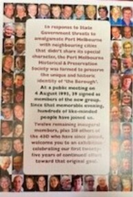 Port Melbourne Historical & Preservation Society
Poster - Panel celebrating 25 years of Port Melbourne Historical & Preservation Society members, Pat GRAINGER, 2018
Display panel made for the 2018 exhibition in the Port Melbourne Town Hall to celebrate 25 years since the founding of the Port Melbourne Historical & Preservation Society in 1993. Top row L to R - Perce MAGUIRE-WHITE (Founding member): Wendy MORRIS (Founding member): Terry KEENAN (Founding member): John MAY (Founding member): Susan REIDY (Founding member): Jim POWER (Founding member): Margaret BRIDE (Founding member): Graham BRIDE (Founding member): Anne CALLAGHAN (Founding member) : Glen STUART (Founding member): Lorraine HALL (Founding member): 2nd row L - R - Heather WALE (Founding member): Pat GRAINGER: Nicholas CREE: Ron STRANKS 3rd row L - R Bob GARDINER: Barbara GARDINER: John WRIGHT: Liana THOMPSON: 4th row L - R - David THOMPSON: Glen COSHAM: Sherrie ANTONIO: Greg HANSEN: 5th row L - R - Suzy MILLBURN: Janet BOLITHO: Maree CHALMERS: Maralyn KOBELT: 6th row L - R - Ann GIBSON: Jack BOLT: Helen BARRY: Virginia SNELL: 7th row L - R - : Marilyn ALLPORT: Max ALLPORT: Robyn CLINCH: Allan MIERS: 8th row L - R - ?: Jan SOLDATOS: Vera WHITE : Peter LOGAN: 9th row L - R - Dorothy OLIVE: Eddie BUSUTTIL: Chris PIPER: George TSINGOS: 10th row L - R - Fiona MCCONNELL: John KIRBY: Phil KING: Rebecca MOORE: 11th row L - R - ? : Steve TSERKEZIDIS: Sue LEONG: Bernadene VOSS: Ann-Marie RICHARDSON: John LACK: Val POWER: Emma TEASDALE: Christine GRIFFITHS: Ray JELLEY: Beris CAMPBELL.Display poster with colour photographs of a selection of members surrounding a text panelcelebrations fetes and exhibitions, perce maguire-white, wendy morris, terry keenan, john may, susan reidy, jim power, margaret bride, graham bride, anne callaghan, glen stuart, lorraine hall, heather wale, pat grainger, nicholas cree, ron stranks, bob gardiner, barbara gardiner, john wright, liana thompson, david thompson, glen cosham, sherrie antonio, greg hansen, suzy millburn, janet bolitho, maree chalmers, "thirst aid" kiosk, maralyn kobelt, ann gibson, jack bolt, helen barry, virginia snell, marilyn allport, max allport, robyn clinch, allan miers, jan soldatos nee harris, vera white, peter logan, dorothy olive, eddie busuttil, chris piper, george tsingos, fiona mcconnell, john kirby, phil king, rebecca moore, arts and entertainment - community arts, 'spud' manners, steve tserkezidis, sue leong, bernadene voss, ann-marie richardon, 'arms' armstrong, john lack, val power, emma teasdale, christine griffiths, beris campbell -
 Federation University Historical Collection
Photograph - Black and White, Chatham-Holmes Collection: Philip Chatham with his mother Imogene Furness
Jessie Imogene [Gene] Chatham ( nee Furness 1901 - 1980) was the grand-daughter of Rosanna McFadden and Alexander Poynton, the 13th child of their eldest daughter Mary Jane Poynton. Philip Chatham was her second eldest child. Rosanna married Liverpool-born Alexander Poynton in the Free Church of Victoria in 1852. According to family legend, Alexander was attracted to Rosanna’s beautiful singing voice, however his proposal was conditional: he would marry her provided the first twelve children were raised as Protestants. Rosanna and Alexander had 14 children. The thirteenth and last surviving child was brought up Catholic. Alexander is reported to have been involved in the Eureka Rebellion, placing Rosanna at Ballarat in late 1854. The family moved about the Victorian Goldfields during the 1850s and early 1860s, before selecting a 240 acre property at Illabarook which they named “The Wattles”. [ https://www.facebook.com/GreatIrishFamineMemorial/photos/a.319845464760508/504144869663899/?type=3&mibextid=WC7FNe&rdid=g7RgSaaGEYbHPsAb&share_url=https%3A%2F%2Fwww.facebook.com%2Fshare%2F16nh8HnJ71%2F%3Fmibextid%3DWC7FNe sited 22 May 2025] Several of the children were born at Port Campbell, Vic. Jessie Imogene Chatham ( nee Furniss) was born at Illabarook, Golden Plains Shire, Victoria, Australia. [Jane Dyer ( nee Chatham) 2025] Rosanna’s first child Alexander, was a State and Federal Politican, holding the role of Treasurer in Billy Hughes government. He was awarded an OBE in 1920 for his work on WW1 repatriation issues. Fifth child Rosanna, married the Mayor of Brunswick and their son Sir Alexander George Wales was Lord Mayor of Melbourne between 1934 – 37. Finally, eleventh son John Joseph was Lord Mayor of Perth. Alexander died in 1896 at the age of 64, while Rosanna lived on to the age of 87, dying on March 9th, 1920. philip chatham, imogene furness, surfers paradise, chatham-holmes collection, queensland holiday -
 Federation University Historical Collection
Photograph, Ballarat Teachers' College, 1953
The Ballarat Teachers' College is a predecessor institution of Federation University Australia. This photograph is reproduced in the 1953 edition of 'Extra Muros', the annual magazine of the Ballarat Teachers' College. Group of first year student of the Ballarat Teachers' College in the grounds of Dana Street Primary School, where their College was located. Back Row: D. Henderson, R. Veal, J. Brasier, D. Nunn, Ken Johnson, G. Osborne, P. Brumby, Graeme Anson, R. Williams, R. Romanes. M. Brennan, M. Jeffey, A. Brown. 2nd Row: John Dixon, K. Ryan, L. Coad, P. Callahan, John Gilbert, H. McLachlan, S. Morgan, J. Campbell, G. Keller, Ian Webster, R. Bryant, J. Hullick, K. Rogers, K. Greenway, B. Thomas. 3rd Row: J. Cameron, M. Simpson, M. McNeil, H. Cornish, C. Brown, A. Mead, Margaret Bywaters, D. Wallish, T. Everett, B. Wallace, A. Flavell, Gwen Brereton, M. Gebbie, V. Rodber, R. Dudley. 4th Row: M. Harvey, M. Beeson, Pat Wilkinson, M. Stevenson, L. Place, M. Barker, J. Bray, Gl. Evans, Gw Evans, D. Vary, Janifer Rogerson, P. Grubb, J. van Leeuwan, D. Bautovich. 5th Row: J. Filcock, J. Watts, B. Peterson, J. McArdle, Helen Sadler, J. Plush, Bette Harvey, R. Rule, E. Leach, D. Carroll, A. unn, B. Laurissen, V. James, J. Higgins. 6th Row: J. Turton, T. Nicoll, J. Wiltshire, A. Bolster, L. Howard, M. Corbett, M. Mill, M. McKay, I. Paul, J. Phelan, P. Ross, J. Piper, W. Jones. Front Row: N. McPherson, G. Lougheed, B. Tonks, I. Work, L. Hall, R. Mason, E. Menadue, E. Mercovich, J. McMillan, P. Fogarty. ballarat teachers' college, d. henderson, r. veal, j. brasier, d. nunn, k. johnston, g. osborne, p. brumby, g. anson, r. williams, m. jeffey, a. brown., k. ryan, l. coad, p. callahan, j. gilbert, h. mclachlan, s. morgan, j. campbell, g. keller, i. webster, r. bryant, j. hullick, k. rogers, k. greenway, b. thomas., m. simpson, m. mcneil, h. cornish, c. brown, a. mead, m. bywaters, d. wallish, t. everett, b. wallace, a. flavell, g. brereton, m. gebbie, v. rodber, r. dudley., m. beeson, p. wilkinson, m. stevenson, l. place, m. barker, j. bray, gl. evans, gw evans, d. vary, janifer rogerson, p. grubb, j. van leeuwan, d. bautovich., 5th row: j. filcock, j. watts, b. peterson, j. mcardle, h. sadler, j. plush, b. harey, r. rule, e. leach, d. carroll, a. unn, b. laurissen, v. james, j. higgins., t. nicoll, j. wiltshire, a. bolster, l. howard, m. corbett, m. mill, m. mckay, i. paul, j. phelan, p. ross, j. piper, w. jones., g. lougheed, b. tonks, i. work, l. hall, r. mason, e. menadue, e. mercovich, j. mcmillan, p. fogarty., r. romanes, m. brennan, j. dixon, j. cameron, m. harvey, j. turton, n. mcpherson, ken johnson, graeme anson, john gilbert, ian webster, margaret bywaters, gwen brereton, 4th row: m. harvey, pat wilkinson, helen sadler, bette harvey, a. nunn, john dixon -
 Bendigo Historical Society Inc.
Map - GUIDE MAP OF BENDIGO & EAGLEHAWK, Late 1920's
Map. Guide map of Bendigo & Eaglehawk. Folded map of Bendigo & Eaglehawk with blue outer cover booklet. Map is compiled by E E Parker, Eaglehawk. Map shows tramways, bus routes and cost one shilling. Map shows Agricultural Showgrounds located between Park Street, Water Street, Barnard Street and Bridge Lane. Also shows Acclimitization Reserve located behind the Botanical Gardens at White Hills. Shows the location of Sailors Gully, Peg-Leg Gully, Jobs Gully, California Gully, Long Gully, Ironbark Gully, Golden Gully, Poverty Gully, Sheepshead Gully, Charcoal Gully, Eaglehawk Creek, Bendigo Creek and Back Creek.Contains interesting facts about Bendigo:- Area - 7,900 acres, Population - 26,000, First Council elected - 1855, Proclaimed a City - 1871. Gold Rush broke out - 1851. For first 10 years gold yield averaged 8,600 ozs. Per week. Total gold yield to 1923 - 572 tons valued at 82,000,000 pounds. Deepest mines - Victoria Quartz 4,614 ft., New Chum Railway 4,318 ft., 13 mines over 3,000ft. deep, 53 mines over 2,000 ft. deep. Sewering of City commenced 1922. All principal buildings now sewered. Map printed by Arnall & Jackson, General Printers, Stationers & Engravers, 476 Collins Street. Outer map blue cover printed in red and blue ink by J B Young, Lithographer. Map displays advertisement for Bendigo Timber Co. Outer blue cover displays advertisement for Campbell Connelly & Co. Pty. Ltd, Ironmongers, Timware Manufacturers, Plumbers, Sewerage Contractors, High and Forest Sts, Bendigo 9outside back cover) and for Hartleys ( J L Shoosmith) Bendigo, displaying Indian Motor Cycles (inside back cover).map, bendigo, township, guide map of bendigo & eaglehawk -
 Clunes Museum
Document - GLENGOWER/GLENDONALD POST OFFICE
.1 PHOTOCOPY OF HISTORY OF GLENDONALD POST OFFICE GLENDONALD POST OFFICE WAS OPENED ON 15 JANUARY 1868, AND WAS MADE A RECEIVING OFFICE ON 19 AUGUST 1894. IT WAS CLOSED ON 1 JULY 1917. IT USED BARRED NUMERAL CANCEL 639. GLENDONALD WAS A SMALL RURAL SETTLEMENT LOCATED ON THE INTERSECTION OF TH CRESWICK-CLUNES ROAD AND MINER'S REST-CASTLEMAINE ROAD BETWEEN CLUNES AND CRESWICK. IT WAS SITED AT THE FOOT OF CATTLE STATION HILL. BETWEEN 1874 AND 1885 THE POST OFFICE WAS CONDUCTED BY THE CATTLE STATION STATE SCHOOL HEADMASTER POST OFFICERS AT GLENDONALD WERE: WILLIAM B. LANGDON 1868 E S LANGDON 1868 - 1870 ELISABETH GOOD 1870-1874 ALEXANDER GILLIAN 1874-1885 ARTHUR W BEAN 1885 CHARLOTTE VALINS 1885 THOMAS DUNSTON 1885-1894 ELIZABETH PEARCY 1894-1901 EDWARD PEARCY 1901-1913 NOT KNOWN 1913-1917 .2PHOTOCOPY OF HISTORY OF GLENGOWER/MIDDLE CREEK POST OFFICE GLENGOWER POST OFFICE OPENED ON 13 JANUARY 1868 AS MIDDLE CREEK. ITS NAME WAS CHANGED ON 1 JUNE 1881, WHEN IT BECAME A RECEIVING OFFICE. A MIDDLE CREEK POST OFFICE WAS OPENED NEAR ARARAT IN 1881 AND THE POSTMASTER GENERAL HAD A POLICY OF NOT HAVING POST OFFICES HAVING THE SAME NAME. GLENGOWER WAS UPGRADED TO POST OFFICE ON 1 JULY 1927, IT CLOSED ON 30 JUNE 1952 BARRED NUMERAL CANCEL 632 WAS USED AT GLENGOWER POST OFFICERS AT GLENGOWER WERE: S IRWIN 1868-1869 DONALD FRASER 1869-1871 JOHN KEMP 1871-1873 JOHN NEWTON 1873-1876 W POTTER 1876-1887 ANNIE MCIVOR 1887-1892 JESSIE MCIVOR 1892-?? UNKNOWSN ????-1927 DJ FRASER 1927-1939 JAMES CAMPBELL 1939-1952middle creek post office, glengower post office, glendonald post office -
 Ballarat Tramway Museum
Slide - 35mm slide/s - set of 19, Noel Simons, 26/02/1972 12:00:00 AM
Set of 18 transparencies taken on 26/2/1972 on Kodak mounts. 1203.1 - Bendigo 5 at Eaglehawk terminus - with new traffic works. 1203.2 - No. 5 climbing the High St. hill Eaglehawk with the buildings on the east side in the photo. 1203.3 - No 2 descending the road over rail bridge at Job's Gully, heading for Quarry Hill. 1203.4 - as for 1202.3, but more side on. Tram has two SEC roof ads. 1203.5 - as for 1202.4 1203.6 - No. 26 entering Garden Gully Loop, Mt. Korong Road, Ironbark. Tram en route to Eaglehawk. Water column on right hand side of photograph. 1203.7 - No. 2 on the Eaglehawk route, Iron Bark area?, bound for Quarry Hill. 1203.8 - as for 1202.7, but photo taken after tram has past photographer. 1203.9 - No. 5 at Eaglehawk terminus, night photo. Tram has arrived at terminus, showing Quarry Hill, pole turned, but the tram lights have yet to be turned around. 1203.10 - as for 1202.9, but lights have been turned around. 1203.11 - No. 26 climbing the View St. Hill near the Commodore Hotel. Has Campbells Electrical Services building in the background. Photo taken after the tram has passed the photographer. 1203.12 - No. 7 end on photograph, at Golden Square, destination showing Golden Square - night photo. 1203.13 - number not used. 1203.14 - as for 1202.12, but partially side on, has a passenger looking out the tram. 1203.15 - as for 1202.12, but with hotel in the background. 1203.16 - No. 26 and 2 at Charing Cross, night photo. Tram 26 en route to Quarry Hill, 2 to Eaglehawk. 1203.17 - Interior photo of No. 26, at night. 1203.18 - No. 26 at the Quarry Hill terminus as night. 1203.19 - as for 1202.18, but central portion of the tramcar.Information written on in blue ink and date stamped on purple ink. 1203.1 - "No. 5 at Eaglehawk terminus" 1203.1 - "No. 5 in High St. Eaglehawk" 1203.3 - "No. 2" 1203.4 - "No. 2" 1203.5 - "No. 2" 1203.6 - "No. 26 at Garden Gully Loop Mt Korong Rd., Ironbark" 1203.7 - "No. 2" 1203.8 - "No. 2" 1203.9 - "No. 5 at Eaglehawk terminus" 1203.10 - "No. 5 at Eaglehawk terminus" 1203.11 - "No. 26 in View St. Near the Commodore Motel" 1203.12 - "No. 7 at Golden Square Terminus" 1203.14 - "No. 7 at Golden Square Terminus" 1203.15 - "No. 7 at Golden Square Terminus" 1203.16 - "Nos. 26 and 2 at Charing Cross" 1203.17 - "Interior of No. 26" 1203.18 - "No. 26 at the Quarry Hill terminus" 1203.19 - "No. 26 at the Quarry Hill terminus "tramways, trams, bendigo, eaglehawk, bridges, iron bark gully, night photo, quarry hill, golden square, tram 2, tram 5, tram 7, tram 26 -
 Bendigo Military Museum
Photograph - Lithographic Squadron Personnel and Equipment, Army Survey Regiment, Fortuna, Bendigo, 1992
This collection of 34 photos of Lithographic Squadron personnel and equipment was taken in at the Army Survey Regiment, Fortuna, Bendigo, in 1992. The photos were mainly taken in the Camera, Contacting, Printing, BARCRO and Production Control work areas, as well as outside Fortuna’s buildings. Although these photos are not annotated most personnel are positively identified. This is a set of 34 photographs of Lithographic Squadron personnel and equipment at the Army Survey Regiment, Fortuna, Bendigo, 1992. Photographs .1P to .32P are on 35mm negative film and scanned at 96 dpi. Colour photos .33P and .34P are on photographic paper and scanned at 300 dpi. They are part of the Army Survey Regiment’s Collection. .1) - Photo, black & white, 1992, back row L to R: Andrew Arman, unidentified Mark McCulloch, Dale Hudson, front row L to R: Daryl South, unidentified (x2). Janet Murray, LT Dave Weston. .2) - Photo, black & white, 1992, back row L to R: unidentified, CPL Paul Baker, Shona Hastie, front row L to R: LT Craig Hersant, Darren Maher, Chad Hardwick, Rob Jones. .3) - Photo, black & white, 1992, WO2 Steve Egan. .4) - Photo, black & white, 1992, LT Craig Hersant. .5)- Photo, black & white, 1992, CPL Warren Shirley, Jeff Willey, Gary Kerr. .6) - Photo, black & white, 1992, L to R: CPL Penny Knott, Janet Murray, Shona Hastie. .7) - Photo, black & white, 1992, L to R: MAJ Terry Edwards, LT David Weston. .8) - Photo, black & white, 1992, Frank Lenane, WO1 Trevor Osborne. .9) - Photo, black & white, 1992, L to R: WO2 Rob Bogumil, WO2 Steve Egan. .10) - Photo, black & white, 1992, back row L to R: Terry Winzar, Roy Hicks Marty Stradbrook, Janet Murray, Nick Vanderzwan, Mark Bird, front row L to R: SGT Dale Hudson, SSGT Russ Mollenhauer, Ross Anza, SGT Kim Reynolds, SGT Stuart Ridge, WO2 Jeff Willey, Peter Hamilton, Garry Lord, Gavin McLean, unidentified. .11) - Photo, black & white, 1992, Janet Murray, Mick Muzeen. .12) and .13) - Photo, black & white, 1992, Janet Murray. .14) to.16) - Photo, black & white, 1992, SPR Scott Cameron, CPL Warren Shirley. .17) - Photo, black & white, 1992, L to R: SPR Shane Campbell, SGT Brian Paul. .18) - Photo, black & white, 1992, LCPL John Bragg. .19) - Photo, black & white, 1992, SPR Allison (Ottaway) Wooldrage. .20) - Photo, black & white, 1992, map inspection station, LT Colin Davidson. .21) - Photo, black & white, 1992, map inspection station. .22) - Photo, black & white, 1992, map inspection station, LT Colin Davidson. .23) and .24) - Photo, black & white, 1992, map inspection station, SPR Nicole Midgley. .25) - Photo, black & white, 1992, map inspection station. .26) - Photo, black & white, 1992, map inspection station, unidentified. .27) - Photo, black & white, 1992, CPL Penny Knott. .28) - Photo, black & white, 1992, CPL Ken Peters. .29) - Photo, black & white, 1992, WO2 Rob Bogumil. .30) - Photo, black & white, 1992, L to R: WO2 Peter Imeson, WO2 Rob Bogumil. .31) and .32) - Photo, black & white, 1992, L to R: SGT Brian Fauth. .33) - Photo, colour, 1992, Klimch Camera, CPL Damien Cole. .34) - Photo, colour, 1992, Speedmaster Printing Press, L to R: SGT Gary Kerr, unidentified, SGT Kim Reynolds, SPR Shane Campbell.No personnel are identified.royal australian survey corps, rasvy, army survey regiment, army svy regt, fortuna, asr, litho -
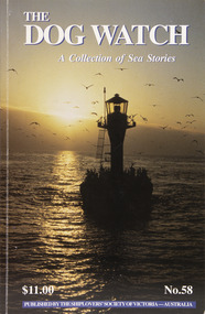 Mission to Seafarers Victoria
Journal (item) - Periodicals-Annual, Shiplovers' Society of Victoria, The Annual Dog Watch
This journal provides the reader with glimpses of the adventures and hardships of a seaman's life. Many of the stories are of sailing ships.Contributes to our knowledge of the importance of shipping and places on record those stories of the sea which would otherwise be lost.Contents Editorial - Harrow Morgan - 5 Captain Angel’s Daughter - Anne Morgan - 6 Australia’s Last Lightships - Ross Meredith - 17 Duyfken Sets Sail — 394 years on - Nick Burningham - 25 Episodes in King Sound - Capt. John Abernethy - 33 Time and Tide - Lynn Sunderland - 38 Explosives in the Port of Melbourne - Cliff Gibson - 39 A Small Misunderstanding - ‘Flinders Bar’ - 51 Mr Bligh’s Bad Health - Ian Campbell - 55 Shipmates - Bernie Sprunt - 64 A Life at Sea - Capt. Ted Daubeny -65 Ketch Hands are Impervious - Noel Smith - Noel Smith - 73 The Devil’s Handwork - R N Thiele - 83 The Beginning of Herzogin Cecilie’s Last Round of Voyage — 1935 - Pamela Eriksson - 85 A Scrap of Flotsam - Esther Hardware - 93 The Waning Skills of Shipwrights - Arthur E Woodley - 96 Trouble in Paradise - Capt. R Jolly - 101 History & Heritage HMAS Castlemaine — the first 60 years - Peter J Williams - 104 The Days of ‘Whack’ and ‘Slush’ - Sir James Bissett - 108 An Unusual Lectern - George C Hogben SSV - 111 Book Reviews - - 112sailing ships, steamships, shipping, seafaring life, shiplovers' society of victoria, dog watch -
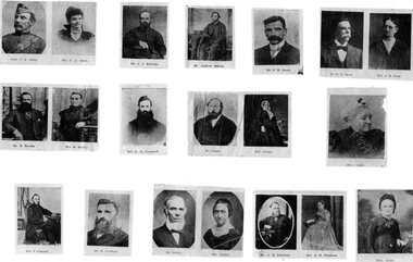 Stawell Historical Society Inc
Photograph, Primitive Methodist Group of Christian Endeavour Stawell
Primitive Methodist 3 pages of small individual photos. The 49 photos of individuals was copies from "The Spectator" May 17, 1907 Stawell Circuit History pages 797 - 804 "Book" Cat no. 843, by Miss Tilly Aston.Individual photo of Primitive Methodists.Names on individual photo's; Mr. C.A. Akins & Mrs. C.A; Mr. J.J. Balding; Mr. Andrew Batten; Bond; Mr. F. W. Bond; Mr. G.M. & Mrs. G. M Bond; Mr. R. & Mrs. R. Brooks; Rev. R. W. Campbell; Mr. & Mrs. Candy; Mrs. Cato; Rev. J. Caterall; Mr. Hugh Crothers; Mr. & Mrs. Dalkin; Mr. A. H. & Mrs. A. H. Freeland; Mrs. Giles; Mr. Jos. Harris; Mrs. Jess & Mr. Jesse Heal; Mrs. C. A. Hird; Mr. Jas. Holden J.P.; Mr. Thos. Hutchings J.P.; Mr. Jory; Mr. & Mrs. Lodwick; Rev. J. A. Marsland; Mrs. Marsland; Mrs. Merfield; Mr. Geo. Middleton; Mr. Isaac Newton; Mr. W.A. Perry Late; Mr. A.H. Phillips; Mr. W.M. & Mrs. Phillips; Mr. Quine; Mr. & Mrs. Robson; Mr. John & Mrs. John Smith; Mr. T. Sussex; Mr. Viant Late; Mrs. S. Walton; Mrs. Wardman; Mrs. Richard Williams; Rev. Woodall (Avoca); stawell -
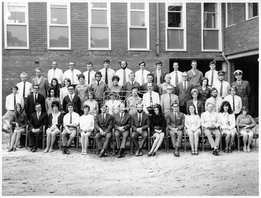 Eltham District Historical Society Inc
Photograph, Hugh Fisher, Eltham Shire Council Staff, Shire Centenary Anniversary, 6 April 1971
Formal photograph of group of men and women employed by the Shire of Eltham, to commemorate the Shire Centenary April 1971. Photograph taken at the rear of the Council Offices, Main Road, Eltham Includes Eltham Shire Council Staff List and Phone Numbers, 1971 1971 Eltham Shire Council Staff Photo (SEPP_4050 and SEPP_4051) L-R Back Row: N. Stuart (Engineering), N. Campbell (Engineering), W. Oakley (Engineering), R. McIldowie (Engineering), D. Welch (Engineering), G. Pullen (Accounts), J. Bleazby (Rates), P. Sturtevent (Engineering), B. Hill (Engineering), F. Harrington (Engineering) Third Row: C. Harris (Building), M. Van Ewijk (Accounts), Miss C. Casella (Administration), Miss D. Curran (Rates), M. Howard (Administration), Dennis McKay (Engineering), Mrs L. Crockett (Accounts), A. Liepa (Engineering), G. Newton (Building), Mrs N. Davis (Administration), I. Leach (Health), Mrs F. Conyers (Rates), B. Wright (ranger), I. Caig (Traffic By-Laws Officer) Second Row: J. Constable (Accounts), J. Parsons (Health), Mrs J. Baker (Health), P. Hoare (Engineering), Miss R. Spearman (Rates), D. Golder (Engineering), Mrs R. Cox (Administration), H. Masefield (Fire Proper Officer), A. Birch (Engineering), Sister L. Cameron (Health), Russell Yeoman (Engineering), T. Phyland (Engineering) Front Row (seated): Miss D. Vreulink (Administration), D. Lovatt (Health), Mrs H. Dixson (Accounts), M. Fowler (Rates), Mrs L. Harris (Administration), C. Gaudion (Health), M. Watson (Shire Secretary), A. Roberts (Administration), Miss J. Featherby (Engineering), M. Verhoeven (Engineering), Mrs M. Lethlean (Engineering), I. McDonald (Rate Collector), Mrs W. Klooster (Engineering), Mrs C. Bell (Engineering) Absent: John McDonald (Shire Engineer) This photo forms part of a collection of photographs gathered by the Shire of Eltham for their centenary project book,"Pioneers and Painters: 100 years of the Shire of Eltham" by Alan Marshall (1971). The collection of over 500 images is held in partnership between Eltham District Historical Society and Yarra Plenty Regional Library (Eltham Library) and is now formally known as the 'The Shire of Eltham Pioneers Photograph Collection.' It is significant in being the first community sourced collection representing the places and people of the Shire's first one hundred years.Digital image Print Foolscap page typedInscribed A2207A (SEPP_4050) 2nd version inscribed A2207B (SEPP_4051)a. birch, a. liepa, a. roberts, b. hill, b. wright, c. gaudion, c. harris, council, council staff, council-staff, d. golder, d. lovatt, d. welch, dennis mckay, eltham-shire-council, f. harrington, g. newton, g. pullen, h. masefield, i. caig, i. leach, i. mcdonald, j. bleazby, j. constable, j. parsons, john mcdonald, m. fowler, m. howard, m. van ewijk, m. verhoeven, m. watson, miss c. casella, miss d. curran, miss d. vreulink, miss j. featherby, miss r. spearman, mrs c. bell, mrs f. conyers, mrs h. dixson, mrs j. baker, mrs l. crockett, mrs l. harris, mrs m. lethlean, mrs n. davis, mrs r. cox, mrs w. klooster, n. campbell, n. stuart, p. hoare, p. sturtevent, r. mcildowie, russell yeoman, shire of eltham centenary, shire of eltham pioneers photograph collection, sister l. cameron, t. phyland, w. oakley -
 Eltham District Historical Society Inc
Photograph, Hugh Fisher, Eltham Shire Council Staff, Shire Centenary Anniversary, 6 April 1971
Formal photograph of group of men and women employed by the Shire of Eltham, to commemorate the Shire Centenary 6 April 1971. Photograph taken at the rear of the Council Offices, Main Road, Eltham 1971 Eltham Shire Council Staff Photo (SEPP_4050 and SEPP_40511) L-R Back Row: N. Stuart (Engineering), N. Campbell (Engineering), W. Oakley (Engineering), R. McIldowie (Engineering), D. Welch (Engineering), G. Pullen (Accounts), J. Bleazby (Rates), P. Sturtevent (Engineering), B. Hill (Engineering), F. Harrington (Engineering) Third Row: C. Harris (Building), M. Van Ewijk (Accounts), Miss C. Casella (Administration), Miss D. Curran (Rates), M. Howard (Administration), Dennis McKay (Engineering), Mrs L. Crockett (Accounts), A. Liepa (Engineering), G. Newton (Building), Mrs N. Davis (Administration), I. Leach (Health), Mrs F. Conyers (Rates), B. Wright (ranger), I. Caig (Traffic By-Laws Officer) Second Row: J. Constable (Accounts), J. Parsons (Health), Mrs J. Baker (Health), P. Hoare (Engineering), Miss R. Spearman (Rates), D. Golder (Engineering), Mrs R. Cox (Administration), H. Masefield (Fire Proper Officer), A. Birch (Engineering), Sister L. Cameron (Health), Russell Yeoman (Engineering), T. Phyland (Engineering) Front Row (seated): Miss D. Vreulink (Administration), D. Lovatt (Health), Mrs H. Dixson (Accounts), M. Fowler (Rates), Mrs L. Harris (Administration), C. Gaudion (Health), M. Watson (Shire Secretary), A. Roberts (Administration), Miss J. Featherby (Engineering), M. Verhoeven (Engineering), Mrs M. Lethlean (Engineering), I. McDonald (Rate Collector), Mrs W. Klooster (Engineering), Mrs C. Bell (Engineering) Absent: John McDonald (Shire Engineer) This photo forms part of a collection of photographs gathered by the Shire of Eltham for their centenary project book, "Pioneers and Painters: 100 years of the Shire of Eltham" by Alan Marshall (1971). The collection of over 500 images is held in partnership between Eltham District Historical Society and Yarra Plenty Regional Library (Eltham Library) and is now formally known as 'The Shire of Eltham Pioneers Photograph Collection.' It is significant in being the first community sourced collection representing the places and people of the Shire's first one hundred years.Digital image Print 20 x 25 cmInscribed A2207A (SEPP_4050) 2nd version inscribed A2207B (SEPP_4051)a. birch, a. liepa, a. roberts, b. hill, b. wright, c. gaudion, c. harris, council, council staff, council-staff, d. golder, d. lovatt, d. welch, dennis mckay, eltham-shire-council, f. harrington, g. newton, g. pullen, h. masefield, i. caig, i. leach, i. mcdonald, j. bleazby, j. constable, j. parsons, john mcdonald, m. fowler, m. howard, m. van ewijk, m. verhoeven, m. watson, miss c. casella, miss d. curran, miss d. vreulink, miss j. featherby, miss r. spearman, mrs c. bell, mrs f. conyers, mrs h. dixson, mrs j. baker, mrs l. crockett, mrs l. harris, mrs m. lethlean, mrs n. davis, mrs r. cox, mrs w. klooster, n. campbell, n. stuart, p. hoare, p. sturtevent, r. mcildowie, russell yeoman, shire of eltham centenary, shire of eltham pioneers photograph collection, sister l. cameron, t. phyland, w. oakley -
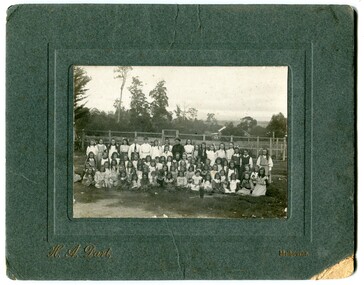 Orbost & District Historical Society
black and white photograph, H.A. Dart, C1890
"The 19th of March 1886 proved an important day in the lives of many early settlers in the Orbost area, because on this day the Orbost State School opened. The fact that the school had first operated temporarily in a leased building, and on a half-time basis with SS2745 Jarrahmond, did not dampen the enthusiasm of the local inhabitants as they saw their offspring commence their education under the guidance of HT Campbell Mackay. However he remained in charge only until 12th of May 1886. The second HT, John Rowe, served until 1908. On 30th of June 1887, a portable room was provided; it being brought to the area by schooner. The school now had accommodation for 30 pupils; the teacher's welfare was considered because quarters of two rooms were attached. As the population increased so did the needs of the school. This was reflected in the provision of a larger classroom in 1898. During 1910-11 the first approaches were made to the Department for the establishment of a HES in Orbost and this became a reality in 1912. Orbost HES supplied post-primary education in the district until a high school was built in 1948. When fire destroyed the school in 1941 local halls were used as classrooms until a new school was built. Work was quite rapid and a new brick structure was opened by the Hon. A. E. Lind, MLA, on 13th of February 1942. This new building was a fine type of school of which both the pupils and the HT Leslie Collins were indeed proud. But Orbost continued to develop and the new school was soon overtaxed. This resulted in the erection of two Bristol classrooms in 1947. By 1950, when the school population had reached 500 pupils the opening of the new school at Orbost North was welcomed by all concerned. In 1963 the Department purchased land diagonally opposite the school and developed it as a playing area. In 1965 two LTCs were opened in November, and in October 1968 the Brodribb School building was moved to SS2744 Orbost for use as a general purpose room." This item is associated with the history of education in Orbost.A black / white photograph of a group of students, some kneeling, some sitting, in a school yard. It is framed in grey buff cardboard with a photographer's stamp at the bottom.H. A. Dart Melbourne in gold print at the bottom.photograph-orbost-state-school -
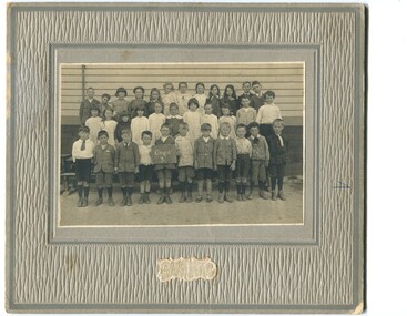 Orbost & District Historical Society
black and white photograph, C1900
The 19th of March 1886 proved an important day in the lives of many early settlers in the Orbost area, because on this day the Orbost State School opened. The fact that the school had first operated temporarily in a leased building, and on a half-time basis with SS2745 Jarrahmond, did not dampen the enthusiasm of the local inhabitants as they saw their offspring commence their education under the guidance of HT Campbell Mackay. However he remained in charge only until 12th of May 1886. The second HT, John Rowe, served until 1908. On 30th of June 1887, a portable room was provided; it being brought to the area by schooner. The school now had accommodation for 30 pupils; the teacher's welfare was considered because quarters of two rooms were attached. As the population increased so did the needs of the school. This was reflected in the provision of a larger classroom in 1898. During 1910-11 the first approaches were made to the Department for the establishment of a HES in Orbost and this became a reality in 1912. Orbost HES supplied post-primary education in the district until a high school was built in 1948. When fire destroyed the school in 1941 local halls were used as classrooms until a new school was built. Work was quite rapid and a new brick structure was opened by the Hon. A. E. Lind, MLA, on 13th of February 1942. This new building was a fine type of school of which both the pupils and the HT Leslie Collins were indeed proud. But Orbost continued to develop and the new school was soon overtaxed. This resulted in the erection of two Bristol classrooms in 1947. By 1950, when the school population had reached 500 pupils the opening of the new school at Orbost North was welcomed by all concerned. In 1963 the Department purchased land diagonally opposite the school and developed it as a playing area. In 1965 two LTCs were opened in November, and in October 1968 the Brodribb School building was moved to SS2744 Orbost for use as a general purpose room. ( info. Schools East Gippsland) This item is associated with the history of education in Orbost.A black / white photograph framed by a grey buff card. It shows grade three students standing in front of a wooden school building.education-orbost orbost-state-school -
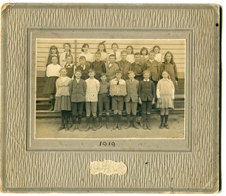 Orbost & District Historical Society
black and white photograph, Wilson, Les G, 1919
The 19th of March 1886 proved an important day in the lives of many early settlers in the Orbost area, because on this day the Orbost State School opened. The fact that the school had first operated temporarily in a leased building, and on a half-time basis with SS2745 Jarrahmond, did not dampen the enthusiasm of the local inhabitants as they saw their offspring commence their education under the guidance of HT Campbell Mackay. However he remained in charge only until 12th of May 1886. The second HT, John Rowe, served until 1908. On 30th of June 1887, a portable room was provided; it being brought to the area by schooner. The school now had accommodation for 30 pupils; the teacher's welfare was considered because quarters of two rooms were attached. As the population increased so did the needs of the school. This was reflected in the provision of a larger classroom in 1898. During 1910-11 the first approaches were made to the Department for the establishment of a HES in Orbost and this became a reality in 1912. Orbost HES supplied post-primary education in the district until a high school was built in 1948. When fire destroyed the school in 1941 local halls were used as classrooms until a new school was built. Work was quite rapid and a new brick structure was opened by the Hon. A. E. Lind, MLA, on 13th of February 1942. This new building was a fine type of school of which both the pupils and the HT Leslie Collins were indeed proud. But Orbost continued to develop and the new school was soon overtaxed. This resulted in the erection of two Bristol classrooms in 1947. By 1950, when the school population had reached 500 pupils the opening of the new school at Orbost North was welcomed by all concerned. In 1963 the Department purchased land diagonally opposite the school and developed it as a playing area. In 1965 two LTCs were opened in November, and in October 1968 the Brodribb School building was moved to SS2744 Orbost for use as a general purpose room. ( Info. from Schools East Gippsland) This item is associated with the history of education in Orbost.A black / white photograph on a grey buff cardboard frame. It is of a group of students standing outside the Orbost State School building. One child holds a sign reading "Form F". There is a photographer's label at the bottom.on back - "Alen Roach" on front - "1919" education-orbost orbost-state-school -
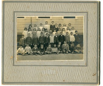 Orbost & District Historical Society
black and white photograph, Wilson, Les G, 1919
The 19th of March 1886 proved an important day in the lives of many early settlers in the Orbost area, because on this day the Orbost State School opened. The fact that the school had first operated temporarily in a leased building, and on a half-time basis with SS2745 Jarrahmond, did not dampen the enthusiasm of the local inhabitants as they saw their offspring commence their education under the guidance of HT Campbell Mackay. However he remained in charge only until 12th of May 1886. The second HT, John Rowe, served until 1908. On 30th of June 1887, a portable room was provided; it being brought to the area by schooner. The school now had accommodation for 30 pupils; the teacher's welfare was considered because quarters of two rooms were attached. As the population increased so did the needs of the school. This was reflected in the provision of a larger classroom in 1898. During 1910-11 the first approaches were made to the Department for the establishment of a HES in Orbost and this became a reality in 1912. Orbost HES supplied post-primary education in the district until a high school was built in 1948. When fire destroyed the school in 1941 local halls were used as classrooms until a new school was built. Work was quite rapid and a new brick structure was opened by the Hon. A. E. Lind, MLA, on 13th of February 1942. This new building was a fine type of school of which both the pupils and the HT Leslie Collins were indeed proud. But Orbost continued to develop and the new school was soon overtaxed. This resulted in the erection of two Bristol classrooms in 1947. By 1950, when the school population had reached 500 pupils the opening of the new school at Orbost North was welcomed by all concerned. In 1963 the Department purchased land diagonally opposite the school and developed it as a playing area. In 1965 two LTCs were opened in November, and in October 1968 the Brodribb School building was moved to SS2744 Orbost for use as a general purpose room. (info. Schools east Gippsland) This item is associated with the history of education in Orbost.A black / white photograph on a grey buff cardboard frame. It is of students outside the Orbost State School. A child in the centre bottom row is holding a sign reading " Grades 5 & 6".on back - "Mary Gilbert"education-orbost orbost-state-school -
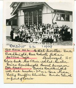 Orbost & District Historical Society
black and white photograph, 1909
This item is part of the Mary Gilbert Collection. Top Row on Left - Ethel Scouller; Una Roadknight; Rene Rodwell; Nathan Spielvogel (Head Teacher) Bottom Left - Elsie Cook; Miss Olivier with hat (teacher); Erica Roadknight, Penuel Cameron Far Right - Dorrie Roadknight;with hat (teacher); 3rd from left Vera Nixon; Sally Draffin behind her; Linda Gluth in front of Dorrie Tthe Orbost State School opened on19th of March 1886. The school had first operated temporarily in a leased building, and on a half-time basis with SS2745 Jarrahmond, The head teacher was Campbell Mackay who remained in charge only until 12th of May 1886. The second head teacher, John Rowe, served until 1908. On 30th of June 1887, a portable room was provided; it being brought to the area by schooner. The school now had accommodation for 30 pupils; the teacher's welfare was considered because quarters of two rooms were attached. As the population increased so did the needs of the school. This was reflected in the provision of a larger classroom in 1898. During 1910-11 the first approaches were made to the Department for the establishment of a Higher Elementary School in Orbost and this became a reality in 1912. Orbost. The Higher Elementary School supplied post-primary education in the district until a high school was built in 1948. When fire destroyed the school in 1941 local halls were used as classrooms until a new school was built, opened by the Hon. A. E. Lind, MLA, on 13th of February 1942. But Orbost continued to develop and the new school was soon overtaxed. This resulted in the erection of two Bristol classrooms in 1947. By 1950, when the school population had reached 500 pupils the opening of the new school at Orbost North was welcomed by all concerned. In 1963 the Department purchased land diagonally opposite the school and developed it as a playing area. This item is associated with education in Orbost.A black / white photograph with a list of names attached to the bottom. It shows a group of students and teachers in front of a wooden school building.on label - Orbost S.S. 1909 with a list of identifying nameseducation-orbost orbost-state-school -
 Flagstaff Hill Maritime Museum and Village
Functional object - Lamp, circa 1878
This Flying Angel lamp bracket was recovered from the wreck site of the steam sailing ship, "Loch Ard", which sank near Port Campbell, Victoria in 1878. It formed part of the ship's cargo. The 'flying angel' lamp was, for a time, displayed in the St Nicholas Seamen's Church at Flagstaff Hill. The design was very appropriate to the Missions to Seamen, being associated with the emblem of the 'flying angel' on the Missions' to Seamen's flag. Brief history of the Loch Ard: The vessel Loch Ard was constructed on the Clyde River in Scotland in 1873 for the prestigious Loch Line of colonial clipper ships, designed for the Australian run. She sailed from England on 1 March 1878 carrying 37 crew, 17 passengers and a diverse general cargo ranging from luxury items to bulk railway iron. On 1 June 1878, emerging from fog and hearing too late the sound of breakers against the tall limestone cliffs, the vessel struck the southern foot of Mutton Bird Island and sank in 23 metres of water. Of the fifty-four people on board only two survived, one young male crewman, Tom Pearce, and one young female passenger, Eva Carmichael. A century later, despite the pounding seas and the efforts of looters, the wreck site continued to provide ample evidence of the extraordinary range of goods being imported into the Colony of Victoria in the post-Gold Rush era. Flagstaff Hill divers in the 1970s reported finds of “Bottles of champagne, window panes, rolls of zinc, barrels of cement, iron rails, clocks, lead shot, corrugated iron, lead, marble, salad oil bottles, ink bottles, copper wire, gin bottles, rolls of carpet, floor tiles, copper rivets, gas light fittings, pocket knives, toys, crystal chandeliers, beer mugs, cutlery, candles sticks, wick scissors, cow bells, and sauce bottles.” The lamp bracket is significant for its connection with the wreck of the sailing ship, Loch Ard, in 1878. Flagstaff Hill’s collection of artefacts from LOCH ARD is significant for being one of the largest collections of artefacts from this shipwreck in Victoria. It is significant for its association with the shipwreck, which is on the Victorian Heritage Register (VHR S417). The collection is significant because of the relationship between the objects, as together they have a high potential to interpret the story of the LOCH ARD. The LOCH ARD collection is archaeologically significant as the remains of a large international passenger and cargo ship. The LOCH ARD collection is historically significant for representing aspects of Victoria’s shipping history and its potential to interpret sub-theme 1.5 of Victoria’s Framework of Historical Themes (living with natural processes). The collection is also historically significant for its association with the LOCH ARD, which was one of the worst and best known shipwrecks in Victoria’s history. Gas lamp, brass, single burner, wall-mounting bracket, delicately crafted. Ornate decoration features bust of an angel with up-swept wings, or 'flying angel'. Recovered from the wreck of the Loch Ard.Noneflagstaff hill, warrnambool, shipwrecked coast, flagstaff hill maritime museum, maritime museum, shipwreck coast, flagstaff hill maritime village, great ocean road, loch line, loch ard, captain gibbs, eva carmichael, tom pearce, glenample station, mutton bird island, loch ard gorge, lamp fitting, shipwreck artifact, 1878, shipwreck cargo, household effects, 19th century lighting, angel lamp, loch ard lamp, angelic lamp, lighting at sea, marine technology, ship's lighting, flying angel, gas lamp, maritime archaeology, port campbell -
 Flagstaff Hill Maritime Museum and Village
Functional object - Cow Bell, Circa 1878
The artefact is a brass cow bell recovered from the 1878 shipwreck of the LOCH ARD near Port Campbell. It was raised by Flagstaff Hill divers in 1973 and is in storage at the Maritime Village. A cow bell is a bell worn around the neck of free-roaming livestock so herders can keep track of an animal via the sound of the bell when the animal is grazing out of view in hilly landscapes. Although they are typically referred to as "cow bells" due to their extensive use with cattle, the bells are used on a wide variety of animals. The earliest examples of truly recognizable cow bells date back to the Iron Age. The use of iron bells in sub-Saharan African music and the Niger–Congo area is linked to the early iron-making technology spread during the Bantu migrations. The earliest archaeological evidence of bells dates back to more than 5000 years ago, from the 3rd millennium BC in Neolithic China. During this era, there is evidence of early forms of pottery cow bells, which were likely used to keep track of goats, sheep, and cattle. These pottery bells were later replaced by metal bells using brass and other materials. The LOCH ARD was constructed on the Clyde in 1873 for the prestigious Loch Line of colonial clipper ships, designed for the Australian run. She sailed from England on 1 March 1878 carrying 37 crew, 17 passengers and a diverse general cargo ranging from luxury items to bulk railway iron. On 1 June 1878, emerging from fog and hearing too late the sound of breakers against the tall limestone cliffs, the vessel struck the southern foot of Mutton Bird Island and sank in 23 metres of water. Of the fifty-four people on board only two survived, one young male crewman, Tom Pearce, and one young female passenger, Eva Carmichael. (See References or Notes below for further details.)The cow bell is believed to be part of the cargo of the Loch Ard and this shipwreck of the Loch Ard is of historical significance for Victoria. Registered on the Victorian Heritage Register ( S 417), with Flagstaff Hill having a varied collection of artefacts from the Loch Ard. Its collection is significant for being one of the largest accumulation of artefacts from this notable Victorian shipwreck. The collections object is to also give us a snapshot into history so we can interpret the story of this tragic event. The collection is also archaeologically significant as it represents aspects of Victoria's shipping history that allows us to interpret Victoria's social and historical themes of the time. The collections historically significance is that it is associated unfortunately with the worst and best-known shipwreck in Victoria's history. Brass cow bell, covered in encrustations. flagstaff hill, warrnambool, shipwreck coast, flagstaff hill maritime museum, flagstaff hill maritime village, maritime museum, great ocean road, shipwreck artefact, loch ard, mutton bird island, glenample, eva carmichael, tom pearce, flagstaff hill divers, cow bell, horse bell, bell smith, vintage bell, farmer, shepherd, drover, stock bell, brass bell -
 Bendigo Historical Society Inc.
Photograph - Historical Society Field Trip to the Springs at Sedgwick, Abt 2009
The Phil Wilkin Collection contains a series of 11 Items. The related items can be found by clicking on the reference link below. The following history of the Young family and their descendants who lived at the Springs is provided by Phil Wilkin. His Great Grandparents were Frances Young and August Wirth. Phil has also provided notes on the Wilkin Family and some history of the gold mining in Sedgwick. Frances Young's parents Joseph and Margaret Young owned the property called "The Old Place, Preston Vale or Wellington Flat" at Sedgwick near the Springs. Joseph Young owned and Managed the Standard Brewery which was located at Campbells Creek during the late 1800’s early 1900’s. Joseph and Margaret are buried in the Harcourt cemetery. In 1880 August Wirth lived at Mosquito Creek (Lake Eppalock, Victoria) when he married Frances Young. In 1902 they moved to part of Joseph Young's property. They milked cows and sold cattle for a living. One of their children Charles Wirth (Phil Wilkin's Grandfather) bought the land in 1935 after his parents had died. Charles Wirth was a councillor and also was president of the Shire of Strathfieldsaye. The "Old Place" was part of the property owned by members of the family. The old house at the Springs was burnt out by bushfire in January 1944 and much of the stonework was later vandalized by campers. The original Coliban Water Works were designed in 1863 by the Irish engineer Joseph Brady. The system included 70 kilometres of open water channels, aqueducts, syphons and tunnels to carry water (by gravity) from the Coliban River at Malmsbury, north to Castlemaine and Bendigo. Sedgwick is a locality in Central Victoria, Australia. It is located in the City of Greater Bendigo. Facilities include a public hall that opened in 1958 and CFA Rural fire station. It was named Upper Emu Creek until 1901 when it was renamed as Sedgwick after British geologist Adam Sedgwick.Twenty nine photos taken on a field trip by the Bendigo Historical Society to "The Springs" on the main Coliban water channel from Malmsbury to the Sandhurst Reservoir in Bendigo. The water race descends through a concrete chute, and continues sharply around the contour of the hills. Once it descended into a syphon across the gully. The are 182 photos in this series and can be found at 8683.1 to 8683.11. The series also includes photos of the surrounding farming land and the remains of an old house. There are also some notes on the pioneers of the district.history, bendigo, coliban water, joseph brady, irrigation, the springs, sedgwick -
 Bendigo Historical Society Inc.
Photograph - Historical Society Field Trip to the Springs at Sedgwick, Abt 2009
The Phil Wilkin Collection contains a series of 11 Items. The related items can be found by clicking on the reference link below. The following history of the Young family and their descendants who lived at the Springs is provided by Phil Wilkin. His Great Grandparents were Frances Young and August Wirth. Phil has also provided notes on the Wilkin Family and some history of the gold mining in Sedgwick. Frances Young's parents Joseph and Margaret Young owned the property called "The Old Place, Preston Vale or Wellington Flat" at Sedgwick near the Springs. Joseph Young owned and Managed the Standard Brewery which was located at Campbells Creek during the late 1800’s early 1900’s. Joseph and Margaret are buried in the Harcourt cemetery. In 1880 August Wirth lived at Mosquito Creek (Lake Eppalock, Victoria) when he married Frances Young. In 1902 they moved to part of Joseph Young's property. They milked cows and sold cattle for a living. One of their children Charles Wirth (Phil Wilkin's Grandfather) bought the land in 1935 after his parents had died. Charles Wirth was a councillor and also was president of the Shire of Strathfieldsaye. The "Old Place" was part of the property owned by members of the family. The old house at the Springs was burnt out by bushfire in January 1944 and much of the stonework was later vandalized by campers. The original Coliban Water Works were designed in 1863 by the Irish engineer Joseph Brady. The system included 70 kilometres of open water channels, aqueducts, syphons and tunnels to carry water (by gravity) from the Coliban River at Malmsbury, north to Castlemaine and Bendigo. Sedgwick is a locality in Central Victoria, Australia. It is located in the City of Greater Bendigo. Facilities include a public hall that opened in 1958 and CFA Rural fire station. It was named Upper Emu Creek until 1901 when it was renamed as Sedgwick after British geologist Adam Sedgwick.Twenty five photos taken on a field trip by the Bendigo Historical Society to "The Springs" on the main Coliban water channel from Malmsbury to the Sandhurst Reservoir in Bendigo. The water race descends through a concrete chute, and continues sharply around the contour of the hills. Once it descended into a syphon across the gully. The are 182 photos in this series and can be found at 8683.1 to 8683.11. The series also includes photos of the surrounding farming land and the remains of an old house. There are also some notes on the pioneers of the district.history, bendigo, coliban water, joseph brady, irrigation, the springs, sedgwick -
 Bendigo Historical Society Inc.
Photograph - Historical Society Field Trip to the Springs at Sedgwick, Abt 2009
The Phil Wilkin Collection contains a series of 11 Items. The related items can be found by clicking on the reference link below. The following history of the Young family and their descendants who lived at the Springs is provided by Phil Wilkin. His Great Grandparents were Frances Young and August Wirth. Phil has also provided notes on the Wilkin Family and some history of the gold mining in Sedgwick. Frances Young's parents Joseph and Margaret Young owned the property called "The Old Place, Preston Vale or Wellington Flat" at Sedgwick near the Springs. Joseph Young owned and Managed the Standard Brewery which was located at Campbells Creek during the late 1800’s early 1900’s. Joseph and Margaret are buried in the Harcourt cemetery. In 1880 August Wirth lived at Mosquito Creek (Lake Eppalock, Victoria) when he married Frances Young. In 1902 they moved to part of Joseph Young's property. They milked cows and sold cattle for a living. One of their children Charles Wirth (Phil Wilkin's Grandfather) bought the land in 1935 after his parents had died. Charles Wirth was a councillor and also was president of the Shire of Strathfieldsaye. The "Old Place" was part of the property owned by members of the family. The old house at the Springs was burnt out by bushfire in January 1944 and much of the stonework was later vandalized by campers. The original Coliban Water Works were designed in 1863 by the Irish engineer Joseph Brady. The system included 70 kilometres of open water channels, aqueducts, syphons and tunnels to carry water (by gravity) from the Coliban River at Malmsbury, north to Castlemaine and Bendigo. Sedgwick is a locality in Central Victoria, Australia. It is located in the City of Greater Bendigo. Facilities include a public hall that opened in 1958 and CFA Rural fire station. It was named Upper Emu Creek until 1901 when it was renamed as Sedgwick after British geologist Adam Sedgwick.Twenty six photos taken on a field trip by the Bendigo Historical Society to "The Springs" on the main Coliban water channel from Malmsbury to the Sandhurst Reservoir in Bendigo. The water race descends through a concrete chute, and continues sharply around the contour of the hills. Once it descended into a syphon across the gully. The are 182 photos in this series and can be found at 8683.1 to 8683.11. The series also includes photos of the surrounding farming land and the remains of an old house. There are also some notes on the pioneers of the district.history, bendigo, coliban water, joseph brady, irrigation, the springs, sedgwick -
 Bendigo Historical Society Inc.
Photograph - Historical Society Field Trip to the Springs at Sedgwick, Abt 2009
The Phil Wilkin Collection contains a series of 11 Items. The related items can be found by clicking on the reference link below. The following history of the Young family and their descendants who lived at the Springs is provided by Phil Wilkin. His Great Grandparents were Frances Young and August Wirth. Phil has also provided notes on the Wilkin Family and some history of the gold mining in Sedgwick. Frances Young's parents Joseph and Margaret Young owned the property called "The Old Place, Preston Vale or Wellington Flat" at Sedgwick near the Springs. Joseph Young owned and Managed the Standard Brewery which was located at Campbells Creek during the late 1800’s early 1900’s. Joseph and Margaret are buried in the Harcourt cemetery. In 1880 August Wirth lived at Mosquito Creek (Lake Eppalock, Victoria) when he married Frances Young. In 1902 they moved to part of Joseph Young's property. They milked cows and sold cattle for a living. One of their children Charles Wirth (Phil Wilkin's Grandfather) bought the land in 1935 after his parents had died. Charles Wirth was a councillor and also was president of the Shire of Strathfieldsaye. The "Old Place" was part of the property owned by members of the family. The old house at the Springs was burnt out by bushfire in January 1944 and much of the stonework was later vandalized by campers. The original Coliban Water Works were designed in 1863 by the Irish engineer Joseph Brady. The system included 70 kilometres of open water channels, aqueducts, syphons and tunnels to carry water (by gravity) from the Coliban River at Malmsbury, north to Castlemaine and Bendigo. Sedgwick is a locality in Central Victoria, Australia. It is located in the City of Greater Bendigo. Facilities include a public hall that opened in 1958 and CFA Rural fire station. It was named Upper Emu Creek until 1901 when it was renamed as Sedgwick after British geologist Adam Sedgwick.Twenty five photos taken on a field trip by the Bendigo Historical Society to "The Springs" on the main Coliban water channel from Malmsbury to the Sandhurst Reservoir in Bendigo. The water race descends through a concrete chute, and continues sharply around the contour of the hills. Once it descended into a syphon across the gully. The are 182 photos in this series and can be found at 8683.1 to 8683.11. The series also includes photos of the surrounding farming land and the remains of an old house. There are also some notes on the pioneers of the district.history, bendigo, coliban water, joseph brady, irrigation, the springs, sedgwick -
 Bendigo Historical Society Inc.
Photograph - The Young and Wirth Families at Preston Vale, near the Springs Sedgwick, 1880s-1900s
The Phil Wilkin Collection contains a series of 11 Items. The related items can be found by clicking on the reference link below. The following history of the Young family and their descendants who lived at the Springs is provided by Phil Wilkin. His Great Grandparents were Frances Young and August Wirth. Phil has also provided notes on the Wilkin Family and some history of the gold mining in Sedgwick. Frances Young's parents Joseph and Margaret Young owned the property called "The Old Place, Preston Vale or Wellington Flat" at Sedgwick near the Springs. Joseph Young owned and Managed the Standard Brewery which was located at Campbells Creek during the late 1800’s early 1900’s. Joseph and Margaret are buried in the Harcourt cemetery. In 1880 August Wirth lived at Mosquito Creek (Lake Eppalock, Victoria) when he married Frances Young. In 1902 they moved to part of Joseph Young's property. They milked cows and sold cattle for a living. One of their children Charles Wirth (Phil Wilkin's Grandfather) bought the land in 1935 after his parents had died. Charles Wirth was a councillor and also was president of the Shire of Strathfieldsaye. The "Old Place" was part of the property owned by members of the family. The old house at the Springs was burnt out by bushfire in January 1944 and much of the stonework was later vandalized by campers. The original Coliban Water Works were designed in 1863 by the Irish engineer Joseph Brady. The system included 70 kilometres of open water channels, aqueducts, syphons and tunnels to carry water (by gravity) from the Coliban River at Malmsbury, north to Castlemaine and Bendigo. Sedgwick is a locality in Central Victoria, Australia. It is located in the City of Greater Bendigo. Facilities include a public hall that opened in 1958 and CFA Rural fire station. It was named Upper Emu Creek until 1901 when it was renamed as Sedgwick after British geologist Adam Sedgwick.Thirty Four Photos of Joseph Young's property near "The Springs" on the main Coliban water channel from Malmsbury to the Sandhurst Reservoir in Bendigo. This item contains family history of Joeph's descendant Charles Wirth, who was a councillor for the Shire of Strathfieldsaye. The water race descends through a concrete chute, and continues sharply around the contour of the hills. Once it descended into a syphon across the gully. The are 182 photos in this series and can be found at 8683.1 to 8683.11. The series also includes photos of the surrounding farming land and the remains of an old house. There are also some notes on the pioneers of the district.history, bendigo, coliban water, joseph brady, irrigation, the springs, sedgwick, charles wirth, preston vale, joseph and margaret young, standard brewery campbells creek harcourt, phil wilkin collection -
 Bendigo Historical Society Inc.
Photograph - The Sedgwick Gold Mine, abt 1909
The Phil Wilkin Collection contains a series of 11 Items. The related items can be found by clicking on the reference link below. The following history of the Young family and their descendants who lived at the Springs is provided by Phil Wilkin. His Great Grandparents were Frances Young and August Wirth. Phil has also provided notes on the Wilkin Family and some history of the gold mining in Sedgwick. Frances Young's parents Joseph and Margaret Young owned the property called "The Old Place, Preston Vale or Wellington Flat" at Sedgwick near the Springs. Joseph Young owned and Managed the Standard Brewery which was located at Campbells Creek during the slate 1800’s early 1900’s. Joseph and Margaret are buried in the Harcourt cemetery. In 1880 August Wirth lived at Mosquito Creek (Lake Eppalock, Victoria) when he married Frances Young. In 1902 they moved to part of Joseph Young's property. They milked cows and sold cattle for a living. One of their children Charles Wirth (Phil Wilkin's Grandfather) bought the land in 1935 after his parents had died. Charles Wirth was a councillor and also was president of the Shire of Strathfieldsaye. The "Old Place" was part of the property owned by members of the family. The old house at the Springs was burnt out by bushfire in January 1944 and much of the stonework was later vandalized by campers. The original Coliban Water Works were designed in 1863 by the Irish engineer Joseph Brady. The system included 70 kilometres of open water channels, aqueducts, syphons and tunnels to carry water (by gravity) from the Coliban River at Malmsbury, north to Castlemaine and Bendigo. Sedgwick is a locality in Central Victoria, Australia. It is located in the City of Greater Bendigo. Facilities include a public hall that opened in 1958 and CFA Rural fire station. It was named Upper Emu Creek until 1901 when it was renamed as Sedgwick after British geologist Adam Sedgwick.Four photos of the miners and information on the Sedgwick Gold Mine. There are 182 photos in this series and can be found at 8683.1 to 8683.11. The series also includes photos of the surrounding farming land and the remains of an old house. There are also some notes on the pioneers of the district.history, bendigo, coliban water, joseph brady, irrigation, the springs, sedgwick, phil wilkin collection, sedgwick gold mine