Showing 1835 items matching "rivers in victoria"
-
 Kew Historical Society Inc
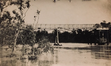
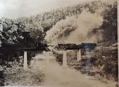
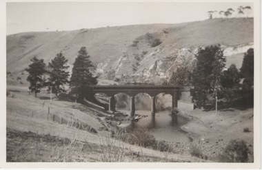
Photograph - Zig-zag Bridge, Kew, Henry Beater Christian, 1920s
An item from an outstanding and diverse photographic collection, assembled by members of the Christian family of Pakington Street, Kew, comprising professional and amateur photography, depicting individuals, natural and settled environments and the interactions between these worlds. Many of the photographs vividly capture the worlds of three generations of men - Henry Christian, his son Orlando Henry Beater Christian, and his grandson of Henry Beater Christian. The most important photographer was the youngest, Henry Christian, who was a keen explorer, not just of his immediate environment but also of the Victorian wilderness. His major opus is contained in two albums in which he records, sometimes in majestic detail and on other occasions the intimate features of the natural world. His photographic travels during the 1920s, often in solitary ramblings but on other occasions with companions, recall the heroic landscape photography of an earlier era, pioneered by Nicholas Caire. In addition to their aesthetic value, the albums are historically significant records within the State of Victoria, of what is now a distant point in time, and of places that have become radically altered through human intervention.Sepia photograph of the wooden trestle Zig-Zag Bridge across the River Yarra. The bridge was built in the 1870s to transport stone from the west side of the Yarra to the east side. The stone was used in the construction of the Kew Asylum. The bridge continued to link the two asylums on each side of the river. yarra river -- kew (vic), zig-zag bridge -- kew (vic.), henry beater christian, christian-washfold collection -
 Kew Historical Society Inc
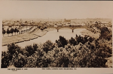
Postcard, Rose Stereograph Company, The Yarra Looking East, Melbourne, Vic
One of a number of 'real photo' and commercial postcards created by or owned by members of the Christian and Washfold families of Kew. The postcards are part of a larger collection of photographs, postcards and publications donated to the collection in May 2021.View of Melbourne on the horizon, looking in an easterly direction along the River Yarra. A State Library of Victoria catalogue record says ‘Elevated view along Yarra River, trees in foreground, line of saplings along both banks of the river, bridge in background (possibly Johnson Street Bridge)’. This may be incorrect.The Rose Series P. 3480yarra river -- melbourne, postcards -- yarra river, the rose series postcards, christian-washfold collection -
 Kew Historical Society Inc
Album - Photograph Album No.1, Henry Beater Christian, 1924-26
Henry Christian (c.1809-91), the grandfather of the photographer, was one of the first settlers in Kew. He arrived in Victoria with his wife Agnes and son Orlando in 1855 on the Gypsy Queen. He established a rope-making business in Bulleen Road by 1858 but was declared insolvent two years later. In his final years, he was celebrated as one of the oldest living settlers of the district. His son, Orlando Henry Beater Christian (c.1853-1930) became a member of the Hawthorn Band and a foundation member of the Willsmere Swimming Club. Orlando and his wife Elizabeth had four children of which Henry Beater Christian (1886-1962) was the oldest.An album of photographs, compiled by Henry Beater Christian (1886-1962) of Pakington Street, Kew, depicting individuals, natural and settled environments and the interactions between these worlds. Henry Christian, was a keen explorer, not just of his immediate environment but also of the Victorian wilderness. His major opus is contained in two albums in which he records, sometimes in majestic detail and on other occasions the intimate features of the natural world. His photographic travels during the 1920s, often in solitary ramblings but on other occasions with companions, recall the heroic landscape photography of an earlier era, pioneered by Nicholas Caire. In addition to their aesthetic value, the albums are historically significant records within the State of Victoria, of what is now a distant point in time, and of places that have become radically altered through human intervention.Digital copy of a 47-page photograph album containing 255 gelatinous silver images, loaned by Diane Washfold with permission given to digitise and hold a copy in our collection. The album contains a groups of photographic positives taken by Henry B Christian (a resident of Pakington Street), of places in Kew and throughout regional Victoria during the 1920s. The mainly sepia photographs, while small, are of a high resolution. Photographs are typically lightly glued onto pages. Locations are frequently identified by white or black ink, which in a number of cases is illegible due to wear.henry beater christian (1886-1962), landscape photography, photograph albums, kew (vic.) — yarra river, kew (vic.) — zig-zag bridge, kew (vic.) — macauley’s boathouse, studley park (vic.) — yarra river, wonderland — grampians (vic.), black spur (vic.), marysville (vic.), maroondah dam (vic.) — construction, warburton (vic.), cockatoo (vic.), bruthen (vic.), swan reach road (vic.), glen hills (vic.), lightning creek (vic.), omeo (vic.), glen wills (vic.), mt wills (vic.), sunnyside (vic), granite flat (vic.), toolangi (vic.), yea (vic, )., flowerdale (vic.), mt white law (vic.), baw baw (vic.), christian-washfold collection -
 Kew Historical Society Inc
Album - Photograph Album No.2, Henry Beater Christian, 1928-30
Henry Christian (c.1809-91), the grandfather of the photographer, was one of the first settlers in Kew. He arrived in Victoria with his wife Agnes and son Orlando in 1855 on the Gypsy Queen. He established a rope-making business in Bulleen Road by 1858 but was declared insolvent two years later. In his final years, he was celebrated as one of the oldest living settlers of the district. His son, Orlando Henry Beater Christian (c.1853-1930) became a member of the Hawthorn Band and a foundation member of the Willsmere Swimming Club. Orlando and his wife Elizabeth had four children of which Henry Beater Christian (1886-1962) was the eldest.An album of photographs, compiled by Henry Beater Christian (1886-1962) of Pakington Street, Kew, depicting individuals, natural and settled environments and the interactions between these worlds. Henry Christian, was a keen explorer, not just of his immediate environment but also of the Victorian wilderness. His major opus is contained in two albums in which he records, sometimes in majestic detail and on other occasions the intimate features of the natural world. His photographic travels during the 1920s, often in solitary ramblings but on other occasions with companions, recall the heroic landscape photography of an earlier era, pioneered by Nicholas Caire. In addition to their aesthetic value, the albums are historically significant records within the State of Victoria, of what is now a distant point in time, and of places that have become radically altered through human intervention.Digital copy of a photograph 24-page album loaned by Diane Washfold with permission given to photograph and hold a copy in our collection. The album contains series of photographic positives taken by Henry Christian (a resident of Pakington Street), of places in Kew and throughout regional Victoria during the late 1920s. The mainly sepia photographs, while small, are of a very high resolution. Photographs are typically lightly glued onto pages. Individual pages may be identified by white ink, which in a number of cases is illegible due to wear. Identifiable locations include: Walhalla, Thomson River, Aberfeldy, Matlock, Jericho, Jordan River, Jamieson, Harrietville, Mt Feathertop, the Alpine Road, Cape Patton, Melbourne, and Kew.henry christian (1886-1962), landscape photography, photograph albums, walhalla (vic.) -- history —— photographs, thomson river (vic.) — history —— photographs, aberfeldy (vic.) -- history —— photographs, matlock (vic.) -- history —— photographs, jericho (vic.) -- history —— photographs, jordan river (vic.) -- history —— photographs, jamieson (vic.) -- history —— photographs, harrietville (vic.) -- history —— photographs, mt feathertop (vic.) -- history —— photographs, alpine road (vic.) -- history —— photographs, kew (vic.) — history—— macauley’s boathouse — photographs, kew (vic.) —— history - kew lunatic asylum — photographs, kew canoe club history — — photographs, cape patton — history— photographs, coronation — george vi — melbourne (vic.), christian-washfold collection -
 Kew Historical Society Inc
Map, MMBW, River Yarra Beautification Schemes, c.1913
The Melbourne and Metropolitan Board of Works (MMBW) was established by an act of the Victorian Parliament in 1890 to prepare for and to implement a sewerage and water reticulation system across what was then inner Melbourne, its surrounding and middle distance suburbs, including Kew. The MMBW was disbanded in 1991.The map collection of the Kew Historical Society has at its core the historic maps assembled and originally stored in the City Engineer's Department of the City of Kew. These include maps in a number of scales. The vast majority of maps were produced by the MMBW in the first two decades of the twentieth century, and are solid working maps, backed by linen for durability. These maps are historically significant to Kew, the City of Boroondara and to the history of the development of state utilities in Victoria. A number of the Kew maps have additional details added by former municipal officers, including the levels reached by various floods. As these were working documents, information was added to them long after the period of their initial production and distribution.Map of the City of Kew showing part of the River Yarra Beautification Schemes. The map shows development to date and the flood levels reached in 1923 and 1924. This map may have been adapted from an earlier map, as most development in central Kew and Studley Park had occurred by this date yet numerous streets are not represented. Public buildings and institutions are clearly represented and named on the map as are significant public transport infrastructure (eg the Outer Circle railway).MELBOURNE AND METROPOLITAN BOARD OF WORKS / RIVER YARRA BEAUTIFICATION SCHEMES / SCHEME / SCALE 10 CHAINS TO AN INCHmelbourne & metropolitan board of works, mmbw maps, mmbw plans, city of kew, flood levels -- kew (vic.), cartography -
 Kew Historical Society Inc
Postcard, Walhalla Train Crossing Thomson Bridge, c.1910
One of a number of 'real photo' and commercial postcards created by or owned by members of the Christian and Washfold families of Kew. The postcards are part of a larger collection of photographs, postcards and publications donated to the collection in May 2021.Small black and white 'real postcard' of the Walhalla Train crossing the Thomson Bridge.Walhalla Train Crossing Thomson Bridgehenry christian (1886-1962), landscape photography, thomson river (vic.), thomson bridge (vic.), trains -- walhalla -- victoria, christian-washfold collection -
 Kew Historical Society Inc
Photograph - Burgess House, Victoria Street (Abbotsford), 1880-1900
... Major floods recurred of the Yarra River on a regular basis ...Major floods recurred of the Yarra River on a regular basis. A flood in 1901 destroyed this house in Victoria Street, Abbotsford. Later print copy of an original photograph. Home of C/N Burgess on the south side of Yarra River. The buildings were washed away in a flood in 1901 The house was in the same location as that on which Handley & Tilly was later built. This would locate it on the north side of Victoria Street, Abbotsford between Burnley Street and the Victoria Street Bridge. Photo shows three men and one woman working in an established garden in front of a weatherboard cottage."Home of C/N Burgess on south side of river; washed away in 1901; Handley & Tilly on site"yarra river -- floods, yarra river flood -- 1901, burgess family -- victoria street -- abbotsford (vic.) -
 Kew Historical Society Inc
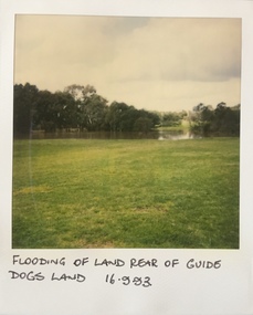
Photograph - Flooding at parkland at rear of Guide Dogs Victoria, 1993
The land currently occupied by Guide Dogs Victoria was once part of the grounds of the Kew Lunatic Asylum. This includes the land, designated as parkland which adjoins the Yarra River. It is now designated as the Chandler Park.Original colour small format polaroid photograph of flooding in parkland at the rear of Guide Dogs Victoria in the area now used as the Main Yarra Trail; taken on 16 September 1993."Flooding of land rear of Guide Dogs land 16.9.93"yarra river -- floods -- kew (vic.), guide dogs victoria, main yarra trail, chandler park -
 Kew Historical Society Inc
Photograph - Flooding of shared path at rear of Guide Dogs Victoria, 1993
The land currently occupied by Guide Dogs Victoria was once part of the grounds of the Kew Lunatic Asylum. This includes the land, designated as parkland which adjoins the Yarra River. Original colour small format polaroid photograph of flooding in parkland at the rear of Guide Dogs Victoria in the area now used as the Main Yarra Trail; taken on 16 September 1993."Flooding of shared path on 16.9.93 / Rains 15.9.93 - rear Guide Dogs [Victoria] land"yarra river -- floods -- kew (vic.), guide dogs victoria, main yarra trail, chandler park -
 Kew Historical Society Inc
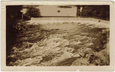
Photograph - The Race at Dight's Falls, 1925
Dight’s Falls in Studley Park is an artificial weir built on a natural rock bar across the Yarra. The weir was built in the 1840s to provide water to the ‘Ceres’ flour-mill, one of the first in Victoria. The falls were later to become known as Dight’s Falls after the owners of the mill. Later, a pumping station was built on the Kew side of the river, which pumped water uphill to a reservoir in Walmer Street that provided water to the Melbourne Botanical Gardens and to Albert Park Lake. The area around Dight’s Falls was and is frequently used for recreational activities.Original, black and white positive of water flowing over the 'Race' at Dight's Falls in MelbourneInscribed verso: "The Race at Dight's Falls / River Yarra Melbourne / 1.3.25" "Kodak Print"dight's falls, river yarra, yarra -- kew (vic.) -
 Kew Historical Society Inc
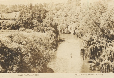
Photograph, River Yarra at Kew, c.1927
The River Yarra was a popular subject for photographic postcards. The postcards provide an interesting perspective of plantings on the banks of the Yarra at various periods. Small, sepia coloured real photo postcard of the River Yarra at Kew. The bird's eye view, presumably taken from Victoria Street Bridge shows the banks of the Yarra in the foreground densely planted with weeping willows. There is also canoe in the foreground. The expanse of lawn in the middle ground is that of 'Swinton', the tower of which can faintly be seen at the top centre of the view. "RIVER YARRA AT KEW / REAL PHOTO SERIES M. 2908 "real photo postcards, yarra river -- kew (vic.), postcards -- 1920s -
 Kew Historical Society Inc
Book, Colin Jones, Ferries on the Yarra, 1981
... ferries -- victoria =- yarra river -- history... -- ferries -- melbourne -- yarra river ferries -- victoria =- yarra ...Collingwood, Vic. : Greenhouse, 1981 108 pages : ill., map ; 26 cm. non-fictionferry services -- ferries -- melbourne -- yarra river, ferries -- victoria =- yarra river -- history, ferries -- victoria -- melbourne -- history. -
Kew Historical Society Inc
Book, Francis Jordan, Guide to historical resources of the Yarra Valley, focusing on conservation and historic landscape, 1992
... landscape -- victoria -- yarra river valley -- history... of natural resources -- victoria -- yarra river valley landscape ...[Ormond, Vic. : F.I. Jordan], 1991 31 leaves : 1 map ; 30 cm. non-fictionconservation of natural resources -- victoria -- yarra river valley, landscape -- victoria -- yarra river valley -- history, ecology -- victoria -- yarra river valley, historic sites -- victoria -- yarra river valley, yarra river valley (vic.) -- history. -
 Expression Australia
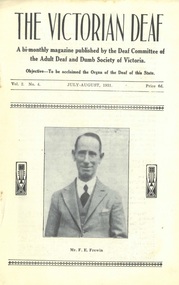
Newsletter, The Victorian Deaf - July-Aug 1931
A bi-monthly magazine published by the Deaf Committee of the Adult Deaf and Dumb Society of Victoria'The Victorian Deaf' Newsletter is a significant publication as an historical record giving and insight into the people, activities and events of the Deaf Community in Victoria.Vol. 2 No. 4, July-August 1931; Size 21.5cmHx14cmWf. e. frewin, school for the deaf, old kent road,rev j. f. frewin, clara e briner, r. a edmanson, john adcock, h. puddy, e. j. d. abraham, e. johnson, g. mortimer, e.r. noble, g. newham, j. mclean, r. h. lambert, w. ashby, w. h. crush, james johnston, warrie ashby, willie elwin, david ashby, l. ching, richard ching, gerald turnley, charlie luke, bert tyzzer, p. sutherland, colin johnsm. gibson, j. mclaurin, mrs rivers, r. betts, l. sanders, mrs j. e. muir, ivan guthrie, joe dickenson, les owen, tom derby, gwen hawkins, jack stewart, maurice mark, byron taylor, robert ryan, mrs g. dumman, emma chambers, miss flynn, claude lyfield, clem noonan, w. shirra, e. cork, j. mcgonigal, g. akester, kit robinson, w. skewes, gracie coghlan, agnes barrie, kate lawrence, jessie love, reggie thaw, jim hartigan, peter clarke, elizabeth sutherland, springbourne, lacrosse, hockey, bagatelle, badminton, billiards, -
 Expression Australia
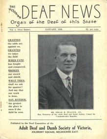
Newsletter, The Victorian Deaf News January 1936
Published by the Deaf Committee of the Adult Deaf and Dumb Society of Victoria'The Victorian Deaf News' Newsletter is a significant publication as an historical record giving and insight into the people, activities and events of the Deaf Community in Victoria.Vol. 1 (New Series) January 1936; Size 24.5cmHx18.5cmW; 24 pagesedgar h. peacock, warwick ashby, rev j. h. frewin, theo frewin, fred frewin, freda connolly, iris connolly, lord mayor's queen carnival campaign, mrs abraham, alice graham, victorian deaf and dumb institution, jim johnston, douglas abraham, w. h. crush, henry w. gladwin, j. boortz, dorothy johnston, charlie buck, colin johns, w. mcmillin, h. r. gillet, i. boast, s. nielson, f. sandon, willie hately, joe unsworth, rivers, a. sutherland, m. reiffel, w. durston, j. boal, deaf tennis club, adult deaf cricket club, lacrosse, deaf chess, w. donnelly, willie smith, les sutton, lydia sanders, melby allsop, ruth peters, mortimer, e. r. e. noble, c. graham, l. smiththelma whateley, thomas newton, roy white, mra and mrs white, h. blackmore, e. raines, elsie denman, g. mccaffrey, ethel dow, james frame, muriel smith, ray cornell, w. grant, john mcgonigal, thomas tonkin, john cardwell, william kent, richard hann, annie secombe, winnie henry, g.g. mercy, -
 Expression Australia
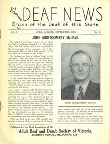
Newsletter, The Victorian Deaf News July-August-September 1937
Published by the Deaf Committee of the Adult Deaf and Dumb Society of Victoria'The Victorian Deaf News' Newsletter is a significant publication as an historical record giving and insight into the people, activities and events of the Deaf Community in Victoria.Vol. 2 No. 6 1937; Size24.5cmHx19cmW; 16 pagesjohn montgomery mclean, may clarke, mrs e. bryan, rev w. h. johnson, a. aird, alice cove, t. a. nelson, ellen whitlow, rose dow, rowe, james, edgar h. peacock, international congress of the deaf and dumb, basketball, lorrie ellis,george mcguinness, bernice cardwell, clarence r. jose, j. m. johnston, w. a. ross, alice c. graham, blackburn home, sllen adcock, hobson, white, ian anderson, rivers, norman may, muriel smith, james, jack reid, ray kemble, ambrose moloney, norma rawlins, j. boortz, taylor, ernest reynolds, e. sturcke, w. duncan, ian hinton, betty doyle, dick white, claude lyfield, alex collins, jack stewart, willie chapmanw. crush, harry puddy, d. scott, alice guest, cove, thomas alexander nelson, ellen whitlow, -
 Queen Victoria Women's Centre
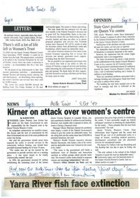
Newspaper excerpt, There's still a lot of life left in Women's Trust, State Govt position on Queen Vic Centre, and Kirner on attack over women's centre, 8 October 1997
A4 page of complied print media about financial troubles and a possible closure of the QVWC. Possibly from all from Melbourne times.Marking in blue pen ink o dates and page numbers. at the bottom there is a cut out o a newspaper headline reading Yarra River fish face extinction and the inscription above reads "And now the Melb Times has the ish facing 'final days'. Seems to be the Melb Times spin on everything" correspondence, historic building, business and finance -
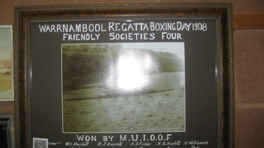 City of Warrnambool Rowing Club
Black and white photograph, Warrnambool Regatta Boxing Day 1908
Won by M.U.I.O.O.F. Crew: W. Marfett stroke, R.J. Russell 3, A.J. Fisher 2, H.G. Marfell bow, V. Williamson cox. “As its name suggests, Manchester Unity Independent Order of Oddfellows (MUIOOF) had its origins in Manchester, England. It was established in Melbourne in 1840 when Augustus Greeves, a member of the MUIOOF in England, migrated to Australia. On his arrival in Melbourne, Greeves teamed up with journalist Thomas Strode, to form the first lodge—The Australia Felix Lodge. The lodge received its Constitution on 7 December 1840 and this is recognised as the birth date of Manchester Unity in Victoria.” Warrnambool rowing club was founded in 1973, with regattas starting in 1885 and a VRA regatta in 1890. Timber framed black and white photograph of a mens rowing crew on the hopkins river, warrnambool.Warrnambool Regatta Boxing Day 1908 Friendly Society's Four Won by: M.U.I.O.O.F.rowing, city of warrnambool rowing club, warrnambool rowing club, hopkins river warrnambool, warrnambool regatta, 1908, 1908 -
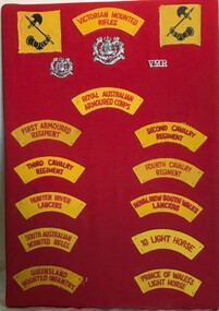 8th/13th Victorian Mounted Rifles Regimental Collection
Memorabilia - Shoulder titles
Embroidered shoulder titles were worn on the upper sleeves of uniform prior to the introduction of colour patches c.1990. Regular regiments used the numerical designations First, Second, Third and Fourth. CMF regiments used their territorial designation: Victorian, Queensland, New South Wales, Hunter River, South Australian, Prince of Wales's and 10th Light Horse. Australia’s defence plans and priorities changed after the Second World War. Decolonisation coupled with competing ideologies created an unstable situation in the Asia-Pacific region. Australia recognised it needed both regular and citizen forces. Six Armoured Corps regiments were formed in 1948, all with territorial titles reflecting their Light Horse heritage. In Victoria they were 4th/19th Prince of Wales’s Light Horse and 8th/13th Victorian Mounted Rifles. The 1st Armoured Regiment, formed July 1949, was the first regular RAAC regiment, followed by 2nd, 3rd and 4th Cavalry Regiments decades later. Unique collection of regimental titles worthy of preservation and display.Display board containing the badge and shoulder title of 8/13 Victorian Mounted Rifles flanked by the formation signs of 2nd Armoured Brigade. These are followed by the shoulder titles of Royal Australian Armoured Corps and eight other RAAC regiments.military, titles, uniform, ara, cmf -
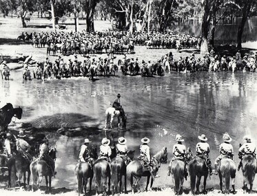 8th/13th Victorian Mounted Rifles Regimental Collection
Photograph
A rare photograph of massed Light Horse in Victoria shortly before mechanisation consigned the horse to history.Black and white photograph of large group of horsemen in ranks waiting in the process of watering horses at a lagoon. One copy of the image claims it to be 8th Light Horse Regiment watering horses at a Murray River lagoon, South Corowa NSW, September 1939; Wahgunyah Troop, C Squadron - this side of lagoon, Lieutenant J. Nott on grey horse in water. A second copy (Cat No 0690) asserts it is 4 regiments of light horse being 8th, 13th, 20th and 4th watering horses near Torquay Victoria, March 1940.On a label on reverse of 0690: "Picture taken about March 1940 when the 13th Light Horse from Gippsland, the 8th Light Horse from Upper Murray, the 4th Light Horse from the Western Districts and the 20th Light Horse from the Goulburn Valley were in camp near Torquay. Mr Cappur Webb of Glendoxey, Seymour, a member of the 20th said the picture must have been taken during and exercise about five miles north of Torquay. “We used to water our horses in that lake”, he said." -
Hand Tool Preservation Association of Australia Inc
Page
This item is part of the Thomas Caine Tool Collection, owned by The National Trust of Australia (Victoria) and curated by the Hand Tools Preservation Association of Australia.Page, sydney harbour + brisbane river bridge -
Hand Tool Preservation Association of Australia Inc
Photograph
This item is part of the Thomas Caine Tool Collection, owned by The National Trust of Australia (Victoria) and curated by the Hand Tools Preservation Association of Australia.Photo river bank scene -
Hand Tool Preservation Association of Australia Inc
Photographs
This item is part of the Thomas Caine Tool Collection, owned by The National Trust of Australia (Victoria) and curated by the Hand Tools Preservation Association of Australia.5 photos, river & bank scenes -
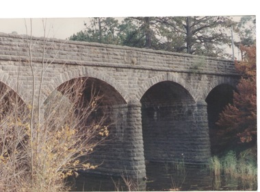 Sunbury Family History and Heritage Society Inc.
Photograph, Bulla Bridge, c 1980s
The bridge in the photograph is the bluestone bridge at Bulla which spans the Deep Creek, a tributary of the Maribyrnong River. It was built in 1869 and replaced a ford crossing which was built further downstream. Many of the buildings and structures in the area were built from bluestone which is in abundance throughout this volcanic area.This bridge is one of many similar structures built across Western Victoria where the bluestone volcanic rock was found in abundance.A coloured close - up photograph of a four-arched blue stone bridge spanning a waterway. Some greenery is visible on either side of the bridge and above it. bulla bridge, bluestone, bridges, deep creek. -
 Sunbury Family History and Heritage Society Inc.
Photograph, 27 June 1934
This is a photograph of the bridge in the Bulla township which spans the Deep Creek, a tributary of the Maribyrnong River. It has been constructed from bluestone which is found across the volcanic western plains in Victoria. Kaolin was quarried from the cliff face in the background and was used in the making of bricks and pottery products manufactured at Northcote and Brunswick potteries.This is one of the many notable bluestone bridges which were built in the district in the nineteenth century.A black and white photograph of a valley with a five arched bridge spanning a river. There are high cliffs in the background.bulla township, deep creek, bridges -
 Sunbury Family History and Heritage Society Inc.
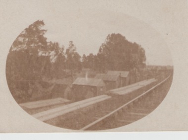
Photograph, c1900
The huts along the railway line were built to house 'navvies' who worked on and maintained the Bendigo-Echuca railway line. At the time this photo was taken, work was being undertaken on the railway line in the Sunbury area.The Bendigo-Echuca was one of Victoria's earliest government owned and operated regional rail systems. It was an important link with the river traffic along the Murray and Melbourne.An oval shaped sepia photograph within cream border of a row of small huts along a railway line. With trees forming a backdrop. railways, 'navvies' -
![Hand-Drawn Map Centred on Myrtleford by Frank Lebbell Frost [ca 1915-1918]](/media/collectors/51d110e42162ef12e06aa06b/items/51fb0bb72162ef156c79aeee/item-media/52a11c442162ef1f0c9c052b/item-fit-380x285.jpg) Beechworth Honey Archive
Beechworth Honey ArchiveHand-Drawn Map Centred on Myrtleford by Frank Lebbell Frost [ca 1915-1918]
This is one of the maps drawn by Frank L. Frost while he was beekeeping in North-East Victoria. This particular map may be reference in the "Wooden" Diary on page 8.Hand-drawn map centred on Myrtleford, Palmerston, Gapstead Road, the Ovens River and the Myrtleford-Wangaratta Road. Shows locations of flowering eucalypts. Scale is 1 mile to 1 inch. Drawn with black pen and grey lead on paper. Names of towns are marked in red pen. hand drawn, hand-drawn, map, myrtleford, palmerston, gapstead, ovens, beekeeping, frost, beechworth honey -
 Melbourne's Living Museum of the West
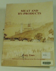
Booklet, Melbourne's Living Museum of the West, Meat and By-Products, 1993
The meat industry and animal by-product works of Melbourne's West, in the series "Interpreting the Cultural Landscape", with the assistance of the Department of Planning and Development, VictoriaThe Australian Meat Preserving Company was established on the banks of the Maribyrnong River in 1870 on the site of boiling works dating from the 1840s.32 page booklet, A5, Cover illustration of Raleigh's boiling down works on the Maribyrnong River, from water-colour by Greeves C. 1850s Title: Meat and By-Products Author: Gary Vines Melbourne's Living Museum of the West Inc.western suburbs, meat industry -
 Maldon Vintage Machinery Museum Inc
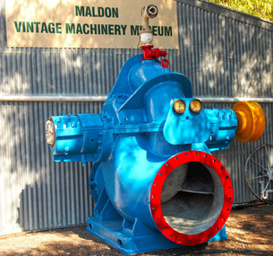
Pump - Centrifugal, Approximately 1954
This pump was situated at Mildura Victoria and pumped water from the Murray river to irrigate the fruit blocks.Large double suction centrifugal pump with 36" suction and discharge branches weighing 7500 kg. Cast iron baseplate for the pump measuring 154 x 185 x 22 cm. The pump is fitted with a spring grid coupling. The pump and baseplate are painted pale blue. The pump identification plate has been removed and there are no markings cast on it. The baseplate has Thompsons cast in relief on the top surface. The coupling has a brass nameplate with Richardson Spring Grid Coupling engraved on it.machinery - pumps; metalwork -
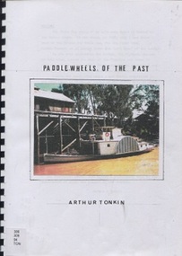 Surrey Hills Historical Society Collection
Book, Paddle wheels of the past
The discovery of inland waterways during the early settlement of Victoria and South Australia led to trade being plied up and down the rivers.An A4 80 page comb bound book.paddlewheels, paddlesteamers - murray river (nsw- sa), boats, punts, barges