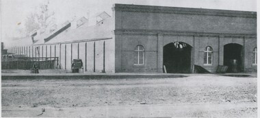
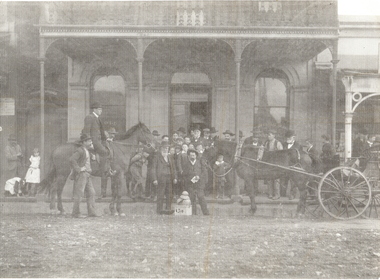
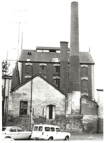
Showing 3287 items matching "windows"
-
 Flagstaff Hill Maritime Museum and Village
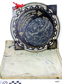
Planisphere, Early 20th Century
The word Planisphere (Latin planisphaerium) was originally used in the second century by Claudius Ptolemy to describe the representation of a spherical Earth by a map drawn in the plane. This usage continued into the Renaissance: for example Gerardus Mercator described his 1569 world map as a Planisphere. The word describes the representation of the star-filled celestial sphere on the plane. The first star chart to have the name "Planisphere" was made in 1624 by Jacob Bartsch. Bartsch was the son-in-law of Johannes Kepler, discoverer of Kepler's laws of planetary motion. A significant item of celestial mapping used by marine navigators This particular item was made and used in the first quarter to half of the 20th centuryPlanisphere of northern hemisphere, with canvas bag. Planisphere consists of a circular star chart attached at its centre to an opaque circular overlay that has a clear elliptical window or hole so that only a portion of the sky map will be visible in the window or hole area at any given time. The chart and overlay are mounted so that they are free to rotate about a common pivot point at their centres. The star chart contains the brightest stars, constellations and (possibly) deep-sky objects visible from a particular latitude on Earth. The night sky that one sees from the Earth depends on whether the observer is in the northern or southern hemispheres and the latitude. A Planisphere window is designed for a particular latitude and will be accurate enough for a certain band either side of that. Planisphere makers will usually offer them in a number of versions for different latitudes. Planispheres only show the stars visible from the observer's latitude; stars below the horizon are not included. A complete twenty-four-hour time cycle is marked on the rim of the overlay. A full twelve months of calendar dates are marked on the rim of the starchart. The window is marked to show the direction of the eastern and western horizons. The disc and overlay are adjusted so that the observer's local time of day on the overlay corresponds to that day's date on the star chart disc. The portion of the star chart visible in the window then represents (with a distortion because it is a flat surface representing a spherical volume) the distribution of stars in the sky at that moment for the Planispheres designed location. Users hold the Planisphere above their head with the eastern and western horizons correctly aligned to match the chart to actual star positions. "Made in Germany for GEORGE PHILIP & SONS Ltd. Geographical and Educational Depot, 32 Fleet Street, London" Canvas bag has "Capt. H (Howard) Tyler from Captain H. F. Woolf" "Tyler 22 ? St East Brighton" also "13 Halls St Flinders"flagstaff hill, warrnambool, shipwrecked-coast, flagstaff-hill, flagstaff-hill-maritime-museum, maritime-museum, shipwreck-coast, flagstaff-hill-maritime-village, planisphere, star map, marine navigation, maps, george philip & sons -
 Flagstaff Hill Maritime Museum and Village
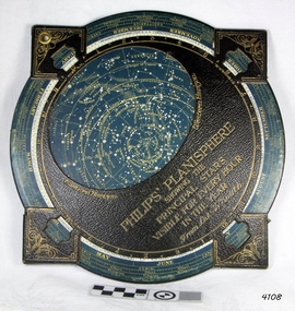
Planisphere, Early 20th Century
The word Planisphere (Latin planisphaerium) was originally used in the second century by Claudius Ptolemy to describe the representation of a spherical Earth by a map drawn in the plane. This usage continued into the Renaissance: for example Gerardus Mercator described his 1569 world map as a Planisphere. The word describes the representation of the star-filled celestial sphere on the plane. The first star chart to have the name "Planisphere" was made in 1624 by Jacob Bartsch. Bartsch was the son-in-law of Johannes Kepler, discoverer of Kepler's laws of planetary motionA significant item of celestial mapping used by marine navigators This particular item was made and used in the first quarter to half of the 20th century.Planisphere consists of a circular star chart attached at its centre to an opaque circular overlay that has a clear elliptical window or hole so that only a portion of the sky map will be visible in the window or hole area at any given time. The chart and overlay are mounted so that they are free to rotate about a common pivot point at their centers. The star chart contains the brightest stars, constellations and (possibly) deep-sky objects visible from a particular latitude on Earth. The night sky that one sees from the Earth depends on whether the observer is in the northern or southern hemispheres and the latitude. A Planisphere window is designed for a particular latitude and will be accurate enough for a certain band either side of that. Planisphere makers will usually offer them in a number of versions for different latitudes. Planispheres only show the stars visible from the observer's latitude; stars below the horizon are not included. A complete twenty-four-hour time cycle is marked on the rim of the overlay. A full twelve months of calendar dates are marked on the rim of the star chart. The window is marked to show the direction of the eastern and western horizons. The disc and overlay are adjusted so that the observer's local time of day on the overlay corresponds to that day's date on the star chart disc. The portion of the star chart visible in the window then represents (with a distortion because it is a flat surface representing a spherical volume) the distribution of stars in the sky at that moment for the Planispheres designed location. Users hold the Planisphere above their head with the eastern and western horizons correctly aligned to match the chart to actual star positions. "Sold by J DONNE & SON, Booksellers & Stationers, 349 Post Office Place Melbourne 349. Admiralty Chart Agents" and " Made in Germany for George Philip & Son Ltd" England . Signature "Capt E. B. ?..id, 22 Baund St"flagstaff hill, warrnambool, shipwrecked-coast, flagstaff-hill, flagstaff-hill-maritime-museum, maritime-museum, shipwreck-coast, flagstaff-hill-maritime-village, star map, marine navigation, maps, george philip & sons -
 Greensborough Historical Society
Photograph - Digital image, Marilyn Smith, St Katherine's Church St Helena: Main window, 29/05/2015
St Katherine's Church St Helena dates from1858. The Church was built by Major Anthony Beale in memory of his wife Katherine Rose Beale. This photograph shows the main stained glass window, dedicated to Anthony and Katherine Beale.Digital copy of colour photographst katherines church st helena, anthony beale -
 Greensborough Historical Society
Photograph - Digital image, Marilyn Smith, St Katherine's Church St Helena: Window 6, 29/05/2015
St Katherine's Church St Helena dates from 1858. The Church was built by Major Anthony Beale in memory of his wife Katherine Rose Beale. This photograph shows one of the stained glass windows, dedicated to Luther Maplestone. Digital copy of colour photographst katherines church st helena, anthony beale, luther maplestone -
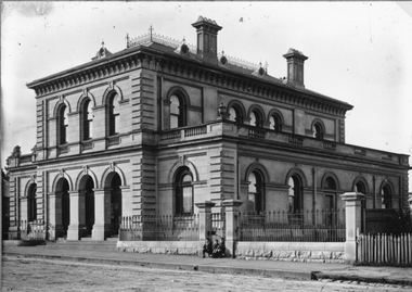 Stawell Historical Society Inc
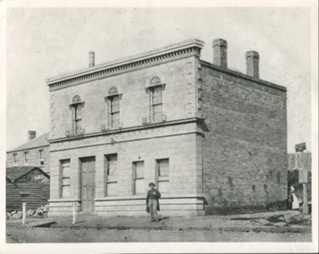
Photograph, Court House in Patrick Street
Court House Patrick Street with photo taken on angle Flanked by metal fence with stone base. Slate roof with ventilators chimneys. Parapet round roof on the single story. Arched windows and entrance. Three children sitting in Gateway.B/W Photgraph of a Substrantional Stone Building - Flanked by a metal Fence on a stoone base - Slate roof, with ventalators, Chimneys - Parapets on the single story Arhed windos and enterance. three young boys sitting in front of the gate, the one to the left is wearing a cap.stawell building, court house -
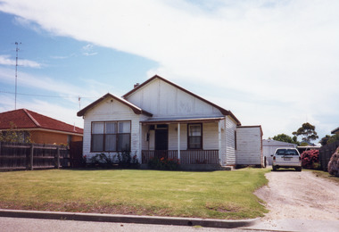 Lakes Entrance Historical Society
Photograph - Historic House, 2000
House built on Rogby Island by Mitchelson around 1915, relocated to corner of Lake Street and Barkes Avenue around 1920, then to Phillips Street 1962. Front window altered, veranda frieze removed, side extension of veranda removed.Colour photograph of a timber residence at 3 Phillips Street. Gable roof, fibro cement section under gables. Front door has fanlight above, widow light beside door filled in. Barge board of gables typical of dwellings built by Leo Mitchelson, Lakes Entrance Victoriahouses, heritage study -
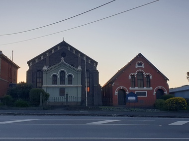 Ballarat Heritage Services
Photograph - Church, Clare Gervasoni, Ebenezer St John's Presbyterian Church, 28/09/2020
Ebenezer Presbyterian Church is located in Armstrong Street South, Ballarat. The earliest church on the site was wooden church was and built in 1857 for the miners Gold Rush. In 1862 the wooden building was replaced by the bluestone church still in use today. The bluestone church was designed by architect Henry Richards Caselli in Lombardic Romanesque style. It features tall windows with paired round headed lights, buttresses and huge brackets. The porch and gallery were added in the 1880s to cater for an increase in the size of the congregation and are the only additions to the church. The 1880s porch features bracketted gables, finial, piers, string course and triple windows. The Ebenezer Church is important architecturally for its interior as well as its exterior, as it has a Classical Revival design that is both distinctive and unusual in Australia. The Ebenezer Presbyterian Church Hall built to the right of the church was constructed in 1892 and is made of locally produced red brick, which was more fashionable at the time. It too has been built in Lombardic Romanesque style in sympathy with the church building and features tall arched windows. The double-storey presbytery, built on the left of the church dates around the 1880s and is also constructed of red brick. Built in Victorian Classical Freestyle, it has elegant quoining on its corners, large windows upstairs, and prominent bay windows on the ground floor. The Armstrong Street facade is sheltered from the sun by a verandah and balcony featuring fine cast iron columns and lacework. The whole complex is surrounded by its 1880s cast iron paling fence. Henry Richards Caselli is perhaps best known in Ballarat for the large number of churches in Victoria that he designed, with two Lombardic Romanesque examples in Ballarat, the Ebenezer Presbyterian church, Armstrong Street South between 1862 and 1863 and the Lutheran Church in Doveton Street in 1876. This photograph was taken during the Covid19 pandemic and the associated shutdowns.Colour photographs of Ebenezer St John's Presbyterian Church.ebenezer st john's presbyterian church, ebenezer, church, ballarat, henry richards caselli -
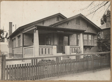 Bendigo Historical Society Inc.
Photograph - T C WATTS & SON COLLECTION: THISTLE STREET, BENDIGO, 1931
Black and white photographs (2) mounted on rectangular brown board. House, California-type bungalow wood and rough cast construction, 2 gables, bow window on right. Large square return verandah with brick and concrete balustrade. 2 double and 1 single window on side plus 1 chimney ( kitchen ) Name of house 'Frostville' centre beam of porch. Wooden slat front fence. On back of photo: A. McIntosh, Thistle Street, £1000 sewered or £950 plus sewer, 15.10.31' 2012 photo of house attached to record.Frank A. Jeffree Photo Bendigo [In Brown]bendigo, business, t c watts and son, s -
 Bendigo Historical Society Inc.
Photograph - BRICK BUILDING, 1861
black and white photo: brick bulding . Commercial ? Brick front with parapet , 2 arched doorways,3 arched windows, building frontrs street. 2 doors to underground cellar open. Windows barred, Side wall has brick buttresses. Galvanised iron roof with 6 glass skylights and louvred ventilator. Rear of Batchelder's cart to left. Male seated near cart. 3 males in timber pens rear of Batcherlders cart to left. Raised footpath. Protective stanchions at entrance door. On back in pencil ' not known' ' 13'Batchelderbuildings, commercial -
 Bendigo Historical Society Inc.
Photograph - ORIENTAL BANK: EAGLEHAWK, 1860's ?
black and white photo mounted on same size board. Group of 30 men and boys outside double storey building with verandah with iron lace. At left man mounted on horse. At rigfht, horse and 4 wheeled vehicle. At centre 2 men, 1 each side of box with '1311' 4 pieces of smooth material piled on box ( smelted gold ? ) At far left, 2 girls, 1 bending down. On left hand window of building 'old' On RH window ' …. Mercial bank'? Above doorway at far left ' private entrance'organization, business, oriental bank, eaglehawk -
 Bendigo Historical Society Inc.
Photograph - FRIEDRICH AND BASSEMEIR VIENNA BAKERY: BENDIGO, 1960's ?
black and white photograph. Brick building, 3 or 4 storey, 2 chimneys, 1 square, 1 round. Lower brick building at front partially painted with 1 window and 1 double door. The door set into partially filled in brick arch. Main building has decorative brick work above windows and at corners of building. 2 vehicles in foreground, 1 sedan, 1 panel van. Corrugated iron roof, finial at each end above gable. Ball point pen on back 'Friedrich and Bassemeir Bakery, FSP/1204.organization, business, friedrich and bassemeir bakery -
 Bendigo Historical Society Inc.
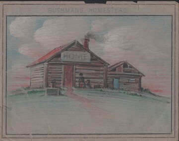
Painting - NORMAN PENROSE COLLECTION: BUSHMAN'S HOMESTEAD
Artwork. Norman Penrose collection: (1) Coloured pencil drawing of a homestead on a hill. Two people in front of the house. In front of the house is a bucket sitting on a box or a well. The house has another building beside it. They both look like log construction. Drawn on grey paper. (2) Tan drawing on light blue paper with a two story building in the background. A man on a ladder is working at the window. Two people are at the other window. There is a tall tree beside the building. In front of the building is a motor car. Three people are having a picnic on the grass beside the car.drawing, pencil, bushmans homestead, norman penrose collection, bushman's homestead -
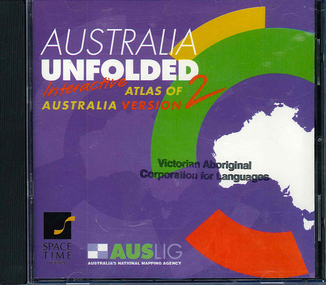 Victorian Aboriginal Corporation for Languages
CD-ROM, Australian Surveying and Land Information Group, Australia unfolded : interactive atlas of Australia, 1996
Systems requirements: Macintosh version: Mac Plus (68030 or higher recommended), 5 MB hard disk space, 2 MB RAM (4 MB RAM recommended), CD-ROM drive, mouse, System 7 or above. "9314231106006"--CD-ROM. System requirements: Windows version: IBM compatible 386 or higher, 5MB hard disk space, 4MB RAM (8MB RAM recommended), VGA monitor, CD-ROM drive, mouse, Windows 3.1 or above. In box (19 x 27 x 5 cm.).CD-ROMtopographic maps, australian maps, surveying -
 Kilmore Historical Society
Photograph, Oriental Bank Corporation, 1866
This photograph was most likely taken for the 1866 Intercolonial Exhibition in Melbourne.25cm x 20cm black and white reproduction of a photograph of the Oriental Bank Corporation, 7 Sydney Street Kilmore, from the State Library of Victoria. Double storey building with decorative parapet along roofline, wrought iron balconets at upper storey windows, decorative hood molds above windows, name of bank in stone under ground floor cornice, a man standing on path in front of bank. Woman standing at back of building in shadow. A sign on post at back of building reads: Land for Sale Apply to W. Grace Solicitor Kilmore.Printed on back: REPRODUCTION RIGHTS RESERVED Copied by State Library of Victoria Tenders called for erection of this building in March 1864.banks, 19th century -
 Surrey Hills Historical Society Collection
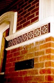
Photograph, Tavistock at 192 Union Road, 1978
The date is approximate. Tavistock was built c1890. In 1897 it was the home of the Walker family; Joyce Walker later became matron of Mosgiel Hospital. In 1902 it became the first site of Milverton Girls School. From 1930s to 1960s it was home to Miss Marjorie Vahland, a locally well-known nursing sister. See History Walks No 5, p 11 and p32 Surrey Hills In Celebration of its Centennial 1883-1983.Colour photo of detail under the front verandah of Tavistock at 192 Union Road, Surrey Hills during restoration during 1978-1982. The house is Victorian in style, of red brick construction with a patterned slate tile roof and decorative chimneys. This photo shows the decorative tiles around the window under the front verandah. These had been stripped of white paint. The photo is taken prior to repainting the masonry. Similar decorative tiles were later also found around the windows at the front. The photo also shows the house name plate.tavistock, milverton girls school, victorian style, houses, 1890-1900, joyce walker, marjorie vahland, union road -
 Bacchus Marsh & District Historical Society
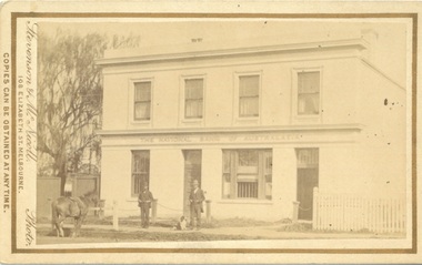
Photograph, Stevenson & McNicoll Photographers, The National Bank of Australasia, Main Street Bacchus Marsh, 1883
This photo of the National Bank of Australasia dates from 1883. The Bacchus Marsh Branch of the National Bank was established in 1862 and moved into its own premises at 127 Main Street in 1865. The building was designed by Leonard Terry and built by J.F.Taylor Snr. Additions to the building were made in 1869 and a banking chamber, in Roman Villa style, was added in 1904. This two storey bank was built with accommodation for the manager and his family who occupied part of the ground floor as well as upstairs. The bank sold these premises to solicitor Pauline Madden in July 1987 and is her current business premises.Small sepia unframed photograph on card with gold border framing photograph. Housed in the album, 'Photographs of Bacchus Marsh and District in 1883 by Stevenson and McNicoll'. The photo shows an elegant two-storeyed building, with a sign ‘The National Bank of Australasia’ running between the two levels. The ground floor has two doors and two windows, the larger one appearing to have a grille open to the public. The upper floor has four windows and looks to be an apartment. Two men stand at the front of the building, one with a dog. A horse is attached to the hitching rail on the street.On the front: Stevenson & McNicoll. Photo. 108 Elizabeth St. Melbourne. COPIES CAN BE OBTAINED AT ANY TIME. On the back: LIGHT & TRUTH inscribed on a banner surmounted by a representation of the rising sun. Copies of this Portrait can be had at any time by sending the Name and Post Office Money Order or Stamps for the amount of order to STEVENSON & McNICOLL LATE BENSON & STEVENSON, Photographers. 108 Elizabeth Street, MELBOURNE. bacchus marsh vic. history, national bank of australasia bacchus marsh branch, stevenson and mcnicoll 1883 photographs of bacchus marsh and district -
 Phillip Island and District Historical Society Inc.
Photograph, Mary Potter, nee Anderson, circa 1930's
Harriett Cunningham and Mary Potter (seated) at Motherwell St, Hawthorn. Mary (nee Anderson) a daughter of Thomas and Catherine Anderson, was born in 1854. Married Rev. Potter in 1884 and died in 1943.Photograph of Mary Potter (nee Anderson) with Harriett Cunningham outside an old bluestone building. Mary seated in wicker chair below verandah steps. Harriett is standing behind chair. A casement window to left. Both ladies very elderly.local history, photography, photographs, slides, film, harriett cunningham, mary potter, black & white photograph, miss elms san remo -
Glenelg Shire Council Cultural Collection
Photograph - Photograph - Andrew Bryant and Darryl Morrison, Portland, c. 1992
Black and white photo. Andrew Bryant, signwriter, and Darryl Morrison, 'Observer' reporter, standing on footpath outside Observer office, Percy St Portland. Large decorative sign on window commemorating 150 years of Portland Observer & Guardian publishingBack: Sticker - 'COPYRIGHT PORTLAND OBSERVER'portland observer 150th anniversary, newspaper, media, celebration -
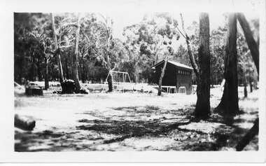 Halls Gap & Grampians Historical Society
Photograph - B/W
This is a photo of the Halls Gap Recreation area. The building is possibly the change shed for the swimming pool.The photo is a distance shot of a tall narrow building with a pitched roof and small windows high up along the side. There is a metal set of swings/ladder and a lower set of metal equipment near the building. It stands in a cleared area surrounded by bush. recreation, sport -
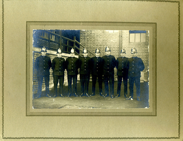 Victoria Police Museum
Photograph (Victoria Police Group Photo), Police Officers group in depot, 1920s
Black and white photograph mounted on light brown frame. 8 Police Officers in 1920s uniform pose in uniforms with helmets. Standfing in a terrace with an open brick building with windows and a set of stairs on the background. Amongst them is William Arthur Poulter.Handwritten: BILL POULTER // 3RD FROM RIGHT Handwritten: The M.C.G. Gang // Collingwood - 93 PTS V Melbourne - 43 PTS // 21.8.26 Stamp: PHOTOGRAPH TAKEN // AT YOUR OWN HOME // P. J. DWYER // Onr. Harding & Salisbury Sts. // COBURG // PHOTOGRAPHS COPIED // AND ENLARGEDpoulter, william, william arthur poulter, victoria police museum, dwyer, p. j., police officers -
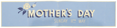 Federation University Historical Collection
Artwork, Signwriting by Keith Rash
Keith Rash was a Ballarat signwriter who studied at the Ballarat School of Mines. .1) Blue paper 'Mother's Day' label, probably for use in a shop window. .2) Pencil rough design featuring an eagle, crown, the number '37' an Australian Flag and and English Flag. The design in on letterhead associated with the Initial Training School.keith rash, signwriting, mother's day, initial training school -
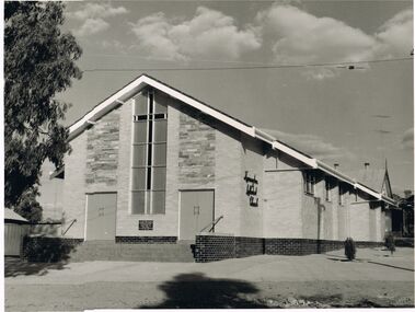 Bendigo Historical Society Inc.
Photograph - KENNINGTON METHODIST CHURCH
black and white photo: Kennington Methodist Church. Brick veneer church, slate inserts alongside of stained glass cross window. Two sets of double doors either side of cross. Written on side of church, 'Kennington Methodist Church'bendigo, church, kennington methodist church, kennington, methodist, church, uniting church -
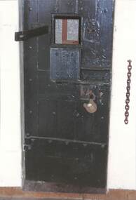 Port Melbourne Historical & Preservation Society
Photograph - Port Melbourne Police Station and lock-up, Jim Hillis, 1996
Taken by Jim HILLIS as a record of the buildingsPhoto of cell door with open window. One of a set of photographs of Port Melbourne police station and lock up taken by Jim HILLIS in 1996 when PMH&PS representatives were given a tour after station was vacated by police:built environment - civic, police, law, police station -
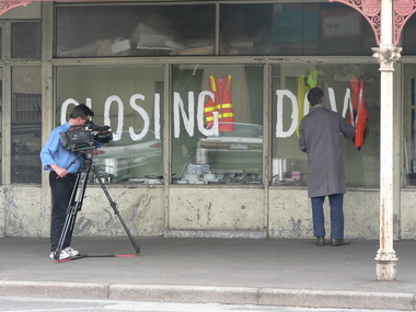 Port Melbourne Historical & Preservation Society
Photograph - Faram Bros Hardware closing, Doug FARAM, 18 Nov 2006
Faram Bros had occupied this site since 1919.Thirteen (13) colour photographs (digital) taken on 18 November 2006. Photos show Doug FARAM painting windows in preparation for closing down sale of this long-running hardware shop. A cameraman (Kevin ANDERSON) is shown recording the preparations.business and traders - hardware, faram brothers hardware, doug faram, kevin anderson -
 Port Melbourne Historical & Preservation Society
Photograph - West and rear wall balcony, first floor, Administration Building, J Kitchen & Sons, Port Melbourne, Lionel Layfield, 2014 - 2015
Photographs taken by ex-employee of Kitchen's, Lionel Hayfield (refer catalogue numbers 3411 and 3412) just before the building sold to "The Block" - a Channel 9 TV program. See also cat nos 3846, 3847 and 3848First floor series of colour photographs taken inside and from the J Kitchen & Sons Administration Building, Ingles St, Port Melbourne. Details where possible are on the back of the photographs. .12 -.16 West and rear wall balcony and windowsindustry - manufacturing, built environment - commercial, built environment - industrial, demolitions, j kitchen & sons pty ltd -
Tatura Irrigation & Wartime Camps Museum
Photograph, Williams Cycle Shop
Williams Cycle Shop was in Walsh Street Tatura.Black and white photo of Williams Cycle Shop, Walshe Street, Tatura. Horse rail in front. Two large and one small bikes leaning on front windows. Verandah has iron decoration. In black plastic glassed frame with L1067williams cycle shop, tatura bicycle shop, walsh street tatura, joyce bell -
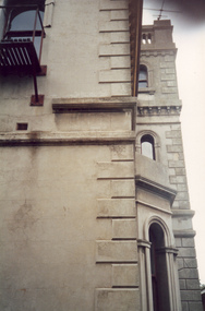 Villa Alba Museum
Photograph - Profile of bay window and tower, c.1987
Built for William and Anna-Maria Greenlaw in the early 1880s, and with interiors decorated by the Paterson Bros, Villa Alba remained in private ownership until 1949. From 1950, the house was owned by a number of institutions. By 1984, the Villa Alba Preservation Society had been formed, and three years later, the Mount Royal Hospital granted a 25-year lease to Kew Council. In 2004, the title to Villa Alba was passed by the Victorian Government to The Villa Alba Museum Incorporated. The Museum, at 44 Walmer Street, Kew, is now a cultural institution committed to the collection, study and display of 19th century interior decorative finishes, and the components of 19th and 20th century interior decoration.This is one of a number of historically and aesthetically significant photos of the interiors and exterior of Villa Alba when it was still owned by the Mount Royal Hospital, showing twentieth century accretions and deterioration of the historic fabric of the building. This was a benchmark survey against which future conservation and restoration activities can be measured.In December 1987, Mockridge Stahle & Mitchell Pty Ltd Architects prepared ‘Villa Alba Survey: A Report on the fabric for Mount Royal Hospital’ of which this photograph is a part. Photo of exterior of Villa Alba showing profile of bay window and tower.villa alba museum, conservation photographs, victorian architecture, cement render, quoins, bay windows, towers -
 Hume City Civic Collection
Photograph, Late 1980's
'Dunhelen' is situated on the Mickleham Road at Greenvale. The rear of the homestead was constructed in the 1850's and the original owners were Richard and George Sinclair Brodie who emigrated from Scotland.A coloured photograph of part of a porchway of a house. The verandah roof is constructed from wooden beams and corrugated iron. The walls are bluestone with granite stone quions around the corners and window frames. The verandah was paved with stone pavers done in a diamond pattern.dunhelen, brodie, george sinclair, richard sinclair, george evans collection -
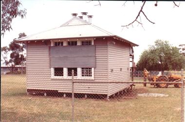 Hume City Civic Collection
Photograph, early 1990s
The small one roomed school is closed at the site along the Calder Highway and was relocated to the new school building in Plumpton Road at Diggers Rest. The former school building became the club rooms for the Diggers Rest Bowling Club when the new school opened in the late 1980s.A coloured photograph of the former Diggers Rest Primary School. The small one roomed weatherboard building with a corrugated iron roof has sheets of iron across the windows. The building is being prepared for relocation. A post hole digger is behind the building.diggers rest primary school, education department, diggers rest bowling club, george evans collection -
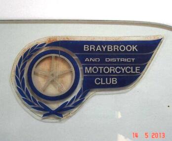 Sunshine and District Historical Society Incorporated
Club Sticker, BRAYBROOK & DISTRICT MOTORCYCLE CLUB
A meeting was held on 18th August 1947 at the East Sunshine Community Hall with the aim of forming a motor cycle club. The name BRAYBROOK MOTOR CYCLE CLUB was decided upon "as it would cater for riders and non-riding members in all surrounding districts". The first President was Don Minahan with Bert Watson as Secretary. They had been members of the Auto Cycle Union whose members became dissatisfied with the prize money awarded, so the Victorian Motorcycle Association (VMCA) was formed. The President of the VMCA (Mr. A. Clarke) attended the meeting on 3rd September 1947 which was held in the Hall behind the Sunshine Theatre. This became the regular meeting place. The new Braybrook Club affiliated with the VMCA joining clubs from Altona, Coburg, Essendon, Newport and Preston. Membership mostly came from recreational motor bike riders looking for more structured competitive riding experience and enjoyment. The club conducted its events on Sunday afternoons and as sport at that time was not permitted on Sundays, they overcame that obstacle by seeking a silver coin donation (pointing out that "two bob" was expected). The events were mainly dirt scrambles over open land which today is known as "off road". The favourite sites were Sunshine's ample open spaces such as Glengala Road and McIntyre Road, as well as Arundell Road (Keilor) and Laverton. For track racing experience the club formed a very basic dirt track on the open land in Glengala Road west of the original Sunshine Golf Club, which was very popular on Sunday afternoons for both riders and spectators. In the early 1950's Motorbike and Sidecar races were also witnessed on some Sundays, on a track near the corner of McIntyre and Furlong Roads, North Sunshine. During 1950 the Braybrook members voted in favour of allowing the Sunshine Club to amalgamate with them and form the BRAYBROOK AND DISTRICT MOTORCYCLE CLUB. The merger took place at the meeting on 10th July 1950 when office bearers were elected. The club disbanded in the mid 1960's due to the massive residential development occurring in the Sunshine district, and so activities were merged with the Newport Club. The above information is mainly compiled from Sunshine Advocate articles published on 29/8/47, 12/9/47, and 30/6/50, and from written details supplied by Mr. J. N. Willaton. Further details or corrections from interested readers are welcome.The Braybrook and District Motorcycle Club has not existed in its own right for several decades. The sticker depicting the club crest serves as a historical reminder that the club was once part of the local recreational scene.Dark blue, silver, and clear plastic sticker on right hand top corner of glass plate that previously was a side window of a car. Sticker has been left on the glass in case removal may damage it. BRAYBROOK AND DISTRICT MOTORCYCLE CLUB.Braybrook and District Motorcycle Clubmotorcycle club, sticker, club sticker, braybrook and district motorcycle club, braybrook