Showing 173758 items
matching street
-
 Kew Historical Society Inc
Plan - Subdivision Plan, Thornton Estate, 1918
The ‘Thornton Estate’ was the final subdivision of ‘Thornton’ in Studley Park Road. Thomas Cubitt Balmain originally owned Thornton, next to John Carson’s ‘Clutha’. Before its final subdivision, the Thomson family owned it. The Estate was a subdivision of 15 residential allotments running between Studley Park Road and Stevenson Street. The allotments faced these streets as well as Thornton Street, which the vendor undertook to make. Contemporary newspaper advertisements advised that ‘The estate possesses many advantages, notably its private and secluded, though convenient, position, splendid frontages and depths, and being close to the electric tram and Kew train, also within easy walking distance of the Victoria-street cable tram’. The terms offered purchasers were ten per cent deposit, with the balance to be paid in ten equal half-yearly payments at a rate of 5 per cent.The ‘Thornton Estate’ was the final subdivision of ‘Thornton’ in Studley Park Road. Thomas Cubitt Balmain originally owned Thornton, next to John Carson’s ‘Clutha’. Before its final subdivision, the Thomson family owned it. The Estate was a subdivision of 15 residential allotments running between Studley Park Road and Stevenson Street. The allotments faced these streets as well as Thornton Street, which the vendor undertook to make. Contemporary newspaper advertisements advised that ‘The estate possesses many advantages, notably its private and secluded, though convenient, position, splendid frontages and depths, and being close to the electric tram and Kew train, also within easy walking distance of the Victoria-street cable tram’. The terms offered purchasers were ten per cent deposit, with the balance to be paid in ten equal half-yearly payments at a rate of 5 per cent.subdivision plans - kew, thornton estate, studley park road -- kew (vic.), thornton avenue -- kew (vic.), stevenson street -- kew (vic.) -
 Port Melbourne Historical & Preservation Society
Photograph - Various streets in Port Melbourne, Ron Laing, 1990 - 1999
Part of Ron LAING's collection of photographs recording Port Melbourne over a thirteen year period. Donated to the PMH&PS by the photographer.A set of 49 colour photographs of varous streets in Port Melbourne, including Graham Street, Swallow Street (before and after wrecking), Bain Street, Graham overpass, Williamstown Road, Normanby Road, Ross Street and Bay Street, Princes Street March 1999 (Number 48 missing August 2015)built environment, ron laing -
 Port Melbourne Historical & Preservation Society
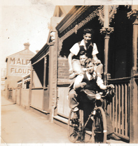
Photograph - Boys on bike Graham Street, Port Melbourne, c.1950
Ahe boy at the top of three on the bike pyramid is Jim SINCLAIR. Under him is Li CLEARIHAN, and seated on the bike itself, Ted McMILLAN (?). The photo taken in front of a brick cottage in Graham Street, Port Melbourne. Part of a sign for McAlpine flour can be seen on a building in the background.Sepia photograph of' three boys apparently on one bike in front of a cottage in Graham Street,Port Melbourne.On reverse: Jim Sinclair, Li Clearihan, Ted McMillan Graham St Port Melbgraham street, jim sinclair, ted mcmillan, mcalpine flour, li clearihan -
 Federation University Historical Collection
Plan, Ballarat Railway Plan, 1888, 27/02/1888
.1) Copy of a Ballarat Railway Plan, running along Belford Street, from the Engineer in Chief's Office, Railway Department. It shows bridges, diversions, culverts and the following streets: Joseph Street, Lal Lal Street, Clayton Street, Belford Street, Rodier Street, trench Street, Stawell Street, Rodier Street, Belford Street, George Street, Eureka Street, Queen Street, Otway Street, Scott Parade, Ross Street, Chamberlain Street, Victoria Street, Water Street. Allotments owned by Tulloch and McLaren, J. Wilson, J. McCarthy, Mrs P. Glynn, E. Ratcliffe, soap works, Orphan Asylum .2) Copy of a plan relating to the construction of the Ballarat Railway Line. It includes shafts for the following companies: South Extended Co, Black Hill; Parade Co.; Black Hill Co.; Spanhake Co. Shaft; Black Hill South Co.; Wellingtonia Gigantiea Co., and the old workings of the Welllingtonia Gigantea Co,ballarat railway plan, belford street, lal lal street, clayton street, rodier street, trench street, south extended co., black hill, parade co., spanhake co. shaft, black hill south co., wellingtonia gigantiea co, railway -
 Orbost & District Historical Society
black and white photographs, 1960s - 1970s
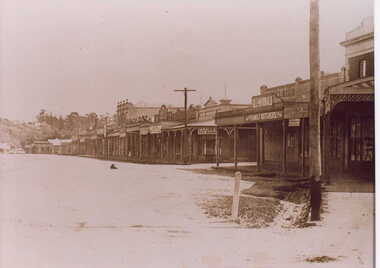
3289.1 has been taken in the main street of Orbost - Nicholson Street. 3289.2 has been taken on the outskirts of Orbost and indicates that the town population at the time was 2800.These photographs are pictorial record of Orbost C1960s - 1970s.3289.1 is a black / white photograph of a main street with cars parked on both sides of the road and buildings on the left hand side. 3289.2 is a black / white photograph of town entry sign - "ORBOST POP. 2800".orbost-nicholson-street main-street-orbost entry-sign-orbost orbost-1960s-1970s -
 Lakes Entrance Historical Society
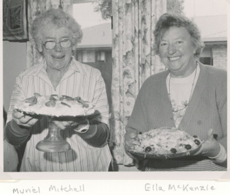
Photograph, Lakes Post Newspaper, International Food Banquet held in the CWA Hall Lakes Entrance Victoria, 1/07/1995 12:00:00 AM
CWA members Muriel Mitchell and Ella McKenzie at International Food Banquet held in the CWA Hall Carpenter Street Lakes Entrance Victoria 1995. These ladies were the best of friends .Black and white photograph of CWA members at International Food Banquet held in the CWA Hall Carpenter Street Lakes Entrance Victoriaclubs, social history -
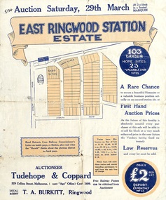 Ringwood and District Historical Society
Flyer, Land Sale Auction Brochure, East Ringwood Station Estate - 1924
Bi-folded double sided sheet with yellow and blue print advertising auction of retail and residential allotments on Saturday, 29 March (1924), including details of subdivision features and local facilities. Subdivision includes Station Street, Wenwood Street, Lois Street, Victoria Street. Auctioneer - Tudehope & Coppard, 229 Collins Street, Melbourne, Tel. Central 2409, in conjunction with local agent, T.A. Burkeitt, Ringwood, Tel. Ringwood 157. -
Clunes Museum
Photograph - PHOTOGRAPHS
.1 The netball court in the photo was where "Collins Place", Fraser Street, Clunes is now located .3 the warehouse/Clunes Museum building at 36 Fraser Street, Clunes, was a former freezing worksPhotocopies of photographs .1 2 copies of girls playing netball .2 A streetscape of Fraser Street, Clunes .3 Del Mayberry (nee Campbell) and friend. The building that is now the warehouse/Clunes Museum is in the background of this photo, the building was a former freezing works .4 Jean Harling (nee Campbell) and male friend, outside The Club Hotel, Fraser Street, Clunes .5 Landscape of Clunes looking towards Station Flat Road. Port Phillip Mine is in the backgroundcampbell, netball, mayberry, harling -
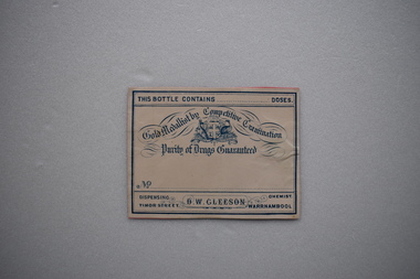 Warrnambool and District Historical Society Inc.
Label, Late 19th century, D.W.Gleeson Chemist
This label comes from the pharmacy of D.W.Gleeson. He had a chemist shop in Timor Street, Warrnambool in the late 19th century. This label is of interest as a memento of a late 19th century chemist in Warrnambool – D.W. GleesonThis is a piece of cream-coloured paper with blue edging, an Australian logo and blue printing. The paper has been pasted on to a piece of pink card. This bottle contains…. doses Gold Medallist by Competitive Examination Purity of Drugs Guaranteed Dispensing Chemist D.W.Gleeson Timor Street Warrnambool d.w.gleeson, chemist, history of warrnambool -
 City of Whittlesea
Photograph - Thomastown Wesleyan Cemetery, Thomastown Methodist / Wesleyan Cemetery photographs
The cemetery was at the rear of the Wesleyan Church in High Street Thomastown. The church, schoolhouse and cemetery were established in 1854. In 1988 the Uniting Church donated the cemetery to the City of Whittlesea as a permanent reminder and tribute to Thomastown's early British pioneersCemetery is located off High Street Thomastown. Official address is 1w Stewart Street Thomastown. The Wesleyan Church and schoolhouse were built in 1854. The cemetery was laid at out at the rear. The cemetery runs along the grounds of the Thomastown Primary School.The last burial was 1955. The Cemetery is maintained by Whittlesea Council.Bicentennial Plaque donated by Mrs Murial Wuchatsch 1988 -
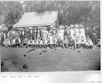 Clunes Museum
Photograph, PURCELL, ROGER, CIRCA 1900
ORIGINAL PHOTOGRAPH PROPERTY OF MR. WILLIAM HARRIS OF SUTHERLAND STREET CLUNES.BLACK & WHITE COPY OF ORIGINAL PHOTOGRAPH - GROUP OF MEN AND WOMEN ASSEMBLED AT EDGE OF BOWLING GREEN AT CLUNES BOWLING CLUB WITH BUILDING BEHIND. ORIGINAL PHOTO MADE BY HORNBY PHOTOGRAPHERS OF CLUNES.ON ORIGINAL "CLUNES BOWLING CLUB MID 1920? "HORNBY CLUNES" ON BACK "H. BARKELL CLUNES" "V. B. OWENS FRASER STREET CLUNES"local history, photography, photographs, sport, bowling club clunes -
Clunes Museum
Document - RECEIPTED INVOICE
DOCKET [INVOICE] AND RECEIPT VEGETABLE PURCHASED FROM T. STANTON CLUNES. BY A. LEVY & CO. PEEL STREET, BALLARAT.RECEIPTED INVOICE. A. LEVY & CO. WHOLESALE FRUIT AND POTATO MERCHANTS PEEL STREET, BALLARAT. T. STANTON OF CLUNES TO SUPPLY VEGETABLES MARCH 25st,1924.local history, commerce, book keeping, a levy & co -
Federation University Historical Collection
Card - Coffee label, South American Coffee, e 16.98 coffee blend, 1998
Full colour printed card front, single colour black print reverse, promoting South American Coffee, 106 Chapel Street, Windsor (supplier of enclosed beans) as part of invitation to third year graduating show of graphic design students, 1998. The coffee beans were specially blended for the exhibition. Opening held Thursday 12 November 1998, 6.00pm at Chapel Off Chapel, 12 Little Chapel Street, Prahran (Melbourne). Exhibition was then open daily until 23 November 1998. 50mm square card featuring "e 16.98" coffee beans blended by South American Coffee, 106 Chapel Street, Windsor university of ballarat, federation university, graphic design, helmut stenzel -
 Clunes Museum
Photograph
FRASER STREET, CLUNES.1 BLACK AND WHITE PHOTOGRAPH OF SHOPS IN FRASER STREET CLUNES-GILL & McDONALD FAMILY BUTCHERS, CLUNES TEA ROOMS AND NEWSAGENCY. .2 BLACK AND WHITE COPY OF PHOTOGRAPH PRINTED ON GLOSS PHOTOGRAPHIC PAPERlocal history, photography, photographs, shops, gill & mcdonald family butchers, clunes tea rooms, newsagent., clunes township -
 Greensborough Historical Society
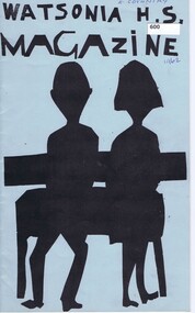
School Magazine, Watsonia High School Magazine 1962, 1962_
Depicts events and attitudes, primarily of students as they go through their adolescent years in the early 1960's. Watsonia High School has now moved to their own buildings in Nepean Street. Annual record of teaching staff, students and events that took place over the year by using both photos and reports. Includes Roll Call section with names of all students.Note: This was the 1st Year of Watsonia's solo publication.20 Pages, Blue cover, Title in black with Illustration of students. Headmaster / Principal - Mr. L.G.MillerOwner's name on coverwatsonia high school -
 Greensborough Historical Society
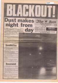
Newspaper clipping, The Melbourne Sun, Blackout! Dust makes night from day, 09/02/1983
Worst dust storm on record for Melbourne occurred at 2.55 pm on 8 February 1983. Visibility was 100m or less in city streets and the temperature was a record high for February of 43.2 degrees.Newsprint, 2p.The Sun News-Pictorialdust storm, melbourne -
 Greensborough Historical Society
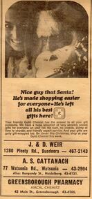
Advertisement - Digital image, Diamond Valley News, Greensborough Pharmacy, 1967, 28/11/1967
Advertisement in the local paper for Greensborough Pharmacy, Main Street Greensborough 1967. Also associated with J & D Weir of Plenty Road Bundoora and A.S. Cattanach of Watsonia Road Watsonia.Part of a collection of historic advertisements from local newspapers, showing local businesses from the mid 20th century.Digital copy of newspaper advertisement.watsonia road, pharmacies, greensborough pharmacy, weir pharmacy, cattanach pharmacy -
 Sunbury Family History and Heritage Society Inc.
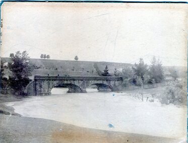
Photograph, 1916 - 1917
The Jacksons Creek is prone to flooding when rainfall is very heavy. The flood pictured in the photograph occurred either in 1916 or 1917 and reached at a level close to the arches on the Macedon Street bridge.A sepia photograph backed on cardboard of a two arched bridge with a river in flood.floods, jacksons creek, macedon street bridge -
 Sunbury Family History and Heritage Society Inc.
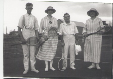
Photograph, c 1920s
The four people had gathered to play a tennis match of the courts which were sited in Evans Street, which is now occupied by then Sunbury Shopping Centre adjacent to the railway line.A black and white photograph of two ladies and two men standing in front of a net on a tennis court.tennis, tennis courts -
 Sunbury Family History and Heritage Society Inc.
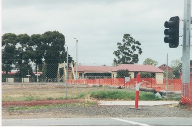
Photograph, c1999
The open are in the foreground was part of railway land on the west side of Sunbury Station along Horne Street. The initial preparations to develop the area into a commercial and entertainment precinct were just commencing. The development that took place on this site was indicative of the growth that was taking place in Sunbury in the early 2000sA coloured photograph of an open area feed off with temporary netting in preparation for construction work. A set of traffic lights are on the RHS of the photograph and a station is in the middle distance.sunbury railway station -
 Brighton Historical Society
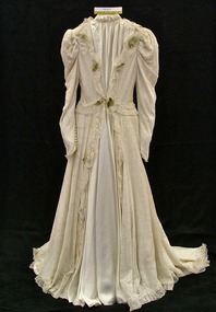
Dress, Wedding dress, 1947
Worn by Edna Emily Seehusen (1916-2005) when she married William Alexander McQuilten (1911-2010) in September 1947 at Brighton Congregational Church, Black Street, Brighton.Ivory satin dress with train overlaid with machine made lace. High, gathered neckline, leg-of-mutton sleeves, In-built padded hip rolls. Front of dress is decorated with wax flowers. Label, woven pink on cream silk, centre back neck: A / Dorothy Draper / Original / EXCLUSIVE TO / BALL & WELCH LTD. / MELBOURNEwedding dress, lace, ball and welch, edna emily seehusen, william alexander mcquilten, brighton congregational church, brighton -
 Surrey Hills Historical Society Collection
Photograph, Subdivision sale of Black's Mont Albert farm in 1924, 1924
Photo was taken in 1924 when the land was subdivided. Black's dairy farm occupied the area just east of Hamilton Street to near Elgar Road. It was subdivided into 88 house allotments along Churchill Street, Bruce Street, Black Street, Proudfoot Street and View Street. The solicitors were Proudfoot & Horton, 360 Collins Street; estate agents were Duncan & Weller, 29 Queen Street. The real estate subdivision notice on the SLV website states that Neil Black had been the owner for 50 years. To date no trace of a Neil Black has been found. Box Hill rate books simply give BLACK as the owner in 1877 (no first name); the entry for 1878-1884 states Robert Black. The 1909 electoral roll has entries for Mont Albert Road for Robert Black (farmer), Thomas Black (carter) & Elizabeth Black (HD). The 1912 electoral roll has entries for Mont Albert Road for Robert Black (farmer), Thomas Black (labourer), John Arthur Black (carter) & Elizabeth Black (HD). Robert Black died in 1920 (b. 1836) and is buried in Box Hill Cemetery (CE-*-0057). His parents were John and Margaret Black. He married Lizzie Foley in 1878. She was the daughter of Margaret & John Foley, born in 1859. She died in 1902 aged 43 years and is buried in the same grave, although the cemetery records record her age as 0 years (presumably as no age or date of birth were given at the time of burial). Children: 1. James Hughbert (1880-1954) 2. John Arthur (1881-1959) 3. Alice (1882-1883) - died aged 6 months 4. Laura Elizabeth (1883-1951) 5. Thomas (1885-1965) 6. Isabella (1887-1963) 7. Eleanor (1889-1963) 8. Ada Maud (1890-1968) 9. Robert (1892-1930). BDM Victoria states places of birth as Box Hill, Surrey Hills or Mont Albert. Many of the family are buried in Box Hill Cemetery. None of the girls appear to have married. Communication from a descendant of John Arthur Black gives the following: "John Arthur Black, son of Robert & Lizzie Foley, married Gladys Anne Layton had 4 children, Robert, Elenore, Marion (Follett) & Annie; they had farm on Stud Road, Dandenong where they milked 30 cows that he retired to after being a earth-moving contractor with draft horses and dug irrigation ditches around Shepparton." This is important as documentation of the area's transformation from farming land to residential land use.Black and white photo of a large 3-poled tent in an area of flat land with eucalypts in the background. There is a large crowd of people, mainly men but also women and children. There are also 3 cars to the RHS.black's dairy farm, dairying, farms, churchill street, black street, proudfoot street, bruce street, view street, neil black, proudfoot & horton, duncan & weller, robert black, lizzie black, lizzie foley, james hubert black, john arthur black, alice black, laura elizabeth black, thomas black, isabella black, eleanor black, ada maud black, robert black jnr, box hill cemetery, land sales -
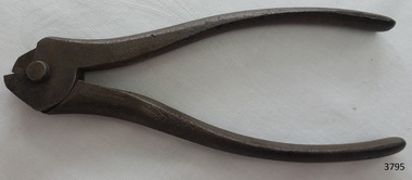 Flagstaff Hill Maritime Museum and Village
Tool - Pliers, Early 20th Century
In 1887 the long established steel toy business of Richard Timmins and Sons of Pershore Street Birmingham was sold to W C Wynn & sons, of Commercial Street Birmingham. They proceeded to extend their works and eventually concentrated on the amalgamation of both businesses under the name of Wynn and Timmins at the one address in Commercial Street. In 1892 they were incorporated as a Limited Company and by 1914 were known as the manufacturers of hand tools for all trades, iron and steel stampers, die sinker, and in the process of press working in sheet and metal for various items. The company around this time employed 200 people and the directors of the company in 1914 were W. H. Wynn, H. S. Wynn, W. L. Wynn. In 1929 they were producing tools under the heart brand until in 1969 the company was taken over by Balfour and Darwins of Sheffield, and the manufacturing facility in Birmingham was closed.An early manufacture of tradesman's tools, from 1900 into the late 1960s the company was a major suppler of tools to various industries and pioneered a number of improvements for individual hand tools for specific industries.Steel snub nosed pliers designed for a specific use unidentified at this time."WYNN & TIMMINS" stamped into the steel handle tools, pliers, metal pliers, wynn & timmins, birmingham manufacturer, tool manufacturer, richard timmins, sheet metal manufactures -
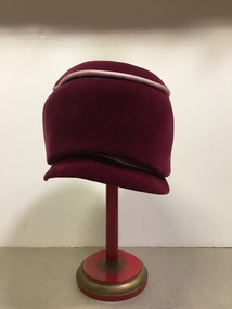 Kew Historical Society Inc
Headwear - Maroon Velvet Hat, Anne Harrison of Kew, 1960s
Marion “Annie” (Cooper) Harrison, a milliner by trade, designed and made women’s hats, initially in the 1940s in High Street, and later in the 1950s and 60s at 5 Princess Street. The hats were constructed upstairs in her shop in Princes Street while the ground floor was reserved for sales and display. She employed other milliners to assist but always ran the showroom herself. Hectic periods were in the weeks before the big racing carnivals when the many wealthy race-goers of Kew kept her busy. She typically walked to her business as she and her husband, Fred Harrison, lived locally. Annie died in April 2016, at the great age of 107 years. Her hats are held in local and national collections. This hat was worn by Kathleen Gervasoni, long term resident and former Mayoress of Kew, who purchased it from Anne Harrison.The Kew Historical Society’s fashion and design collection is comprised of costumes, hats, shoes and personal accessories. Many of these items were purchased or handmade in Victoria; some locally in Kew. The extensive hat collection comprises items dating from the 1860s to the 1970s. While most of the hats in the collection were created by milliners for women, there are a number of early and important men’s hats in the collection. The headwear collection is particularly significant in that it includes the work of notable Australian and international milliners.High crowned, taffeta lined, maroon velvet hat, designed and made by Anne Harrison of Kew. The hat features a narrow stiffened peak of the same fabric at the front and highlighting at the rear of the peak and on the crown in pale pink grosgrain braid. The back of the hat features grosgrain pink braid. Label, inside centre crown, woven in black on white polyester: *WM 9906 /Anne linHarrison OF KEW"anne harrison of kew, kathleen gervasoni, milliners - kew (vic), women's clothing, costume accessories - hats, cloche hats -
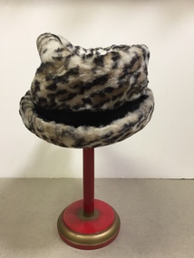 Kew Historical Society Inc
Headwear - Faux Leopard Skin Hat, Anne Harrison of Kew, 1960s
Marion “Annie” (Cooper) Harrison, a milliner by trade, designed and made women’s hats, initially in the 1940s in High Street, and later in the 1950s and 60s at 5 Princess Street. The hats were constructed upstairs in her shop in Princes Street while the ground floor was reserved for sales and display. She employed other milliners to assist but always ran the showroom herself. Hectic periods were in the weeks before the big racing carnivals when the many wealthy race-goers of Kew kept her busy. She typically walked to her business as she and her husband, Fred Harrison, lived locally. Annie died in April 2016, at the great age of 107 years. Her hats are held in local and national collections. This hat was purchased and worn by Kathleen Gervasoni, a long-term resident and former Mayoress of Kew.The Kew Historical Society’s fashion and design collection is comprised of costumes, hats, shoes and personal accessories. Many of these items were purchased or handmade in Victoria; some locally in Kew. The extensive hat collection comprises items dating from the 1860s to the 1970s. While most of the hats in the collection were created by milliners for women, there are a number of early and important men’s hats in the collection. The headwear collection is particularly significant in that it includes the work of notable Australian and international milliners.Faux leopard skin brimmed hat, lined in black, trimmed with two pom poms at back. Designed and made by milliner Anne Harrison of Kew. Anne Harrison designed hats to order for clients, or you could choose a style and have it trimmed to taste.Label, inside centre crown, woven in black on white polyester: "WM 9906 / Anne Harrison OF KEW"anne harrison of kew, kathleen gervasoni, milliners - kew (vic), women's clothing, costume accessories - hats -
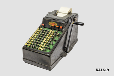 Whitehorse Historical Society Inc.
Equipment - Adding Machine
Built on a cast iron base the machine is designed for Sterling currency with a full-keyboard that has five decimal columns for pounds, three columns for shilling and pence, one column for the 10 and 11 pence keys and three farthing (1/4 penny) keys. The machine was imported and distributed by Chartres Pty. Ltd, Capel Court, 375-377 Collins Street MelbourneHand operated comptometer or adding machine with side handle. Sterling currency with full-keyboard with columns for Pounds Shillings and Pence'Chartres Pty Ltd/Capel Court/375-377 Collins Street Melbourne/23359'commerce, office equipment / stationery, bookkeeping -
 Kew Historical Society Inc
Photograph - 'Fernhurst', 13 Fernhurst Grove, 1978
George Wharton arrived in Melbourne in 1844. An architect and surveyor, he was appointed to lay out the 'Village of Kew' by N.A. Fenwick following the land sales of 1851. A protagonist for Kew's separation from the Boroondara District Road Board, he was elected chairman when Kew achieved municipal status in December 1860. His home, 'Fernhurst', was built in 1866 on eight acres in Studley Park, with a four-storey tower and pyramidal roof. The Italianate home was a prominent Kew landmark. It was demolished in 1979 and replaced by St Paul's College in 1980.Rare colour photograph of what was once a significant mansion in Kew.Original colour positive photograph (Kodak print) of 'Fernhurst' in 1978. Photographed by Stewart West in May 1978, one year before it was demolished, the photograph gives little idea of the large landholding once surrounding the house. Originally accessed from near the corner of Princess Street and Studley Park Road, its gardens had been subdivided in the 1900s and its footprint restricted to 13 Fernhurst Grove. Like many other grand houses, by the 1970s it had been converted into apartments. From the photograph, one can see that the house had retained many of its original features such as the distinctive tower and the wide bow-fronted verandah. The slates on the roof (apart from those on the tower) had been replaced by tiles and the cement render of the exterior painted white. Annotated reverse: "View of Fernhurst Home Taken from Street / 10"fernhurst, 13 fernhurst grove -- kew (vic.), george wharton, italianate architecture, vila maria society, st paul's school for the blind -
Port Melbourne Historical & Preservation Society
Card - Advertising for 'throat weakness' remedy, 1900s
In a box dug up during renovations at 78 Station StreetFrom a box of objects dug up at 78 Station Street: cigarette box, matchbox, greeting card "Remembrance" and advertising card for "throat weakness", dating early to mid 1900sdomestic life -
Whitehorse Historical Society Inc.
Document, Excerpts from Sands & McDougall Directories, 1900, 1920, 1925, 1930, 1949
Photocopied pages from Sands & McDougall Directories covering Mitcham.Photocopied pages from Sands & McDougall Directories covering Mitcham. 1900 and 1949 give details of residents along streets. - others only list of residents in Mitcham.Photocopied pages from Sands & McDougall Directories covering Mitcham.mitcham, directories -
Port Melbourne Historical & Preservation Society
Photograph - CD-ROM, various Port Melbourne images, Charles Nettleton, 1875 - 1911
Gives us a visual description of Bay Street and other highlights in the late 1800s to early 1900sCD of digitised images from late 1800s to early 1900s. Images are of Bay St, from the North East; the Freemasons Hotel; Corner Beach and Stokes Streetsnatural environment - beaches and foreshore, built environment - commercial, bay street, beach street, stokes street, charles nettleton, carlton ale, fosters lager beer, whittle, business and traders - hotels, freemason's tavern