Showing 3911 items
matching creek street
-
 Hume City Civic Collection
Photograph
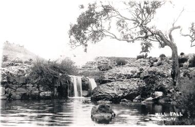
Eadie's Mill on Jacksons Creek was one of the earliest mills to be established in the area. Sunbury Waterworks now occupies the site.A black and white photograph of a small waterfall cascading over rocks into a waterhole in Jacksons Creek. It is near the ruins of Eadies Flour Mill, Sunbury, just up from the sewerage treatment plant.eadies flour mill, jackson creek, eadie, peter, waterfalls, george evans collection -
 Hume City Civic Collection
Photograph, c1900s
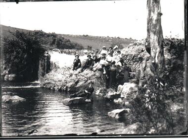
The photograph has been printed from a glass negative which is part of the collection held by the Sunbury and District Heritage Association Inc. It is a view of Jackson's Creek near Eadies Mill.A black and white photo of a group of people sitting on an embankment and one man sitting on a large rock by Jackson's Creek. The men and women are dressed in suits and/or dresses. There is a waterfall behind and to the left of the party and a tree trunk in the foreground. Black and white with broad black margin on either side of the photograph.jackson's creek, sunbury, sunbury and district heritage association inc., clothing and dress, george evans collection -
 Hume City Civic Collection
Photograph, C 1908
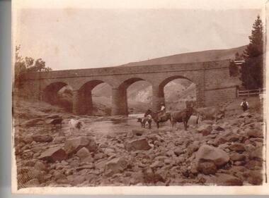
This photo came from an album of photos associated with the Grant Family of Bulla. The album was in poor condition and so the photos were removed from it for archival storage. They were numbered in the order they appeareed in the album. Most of the photos were of the creek area in Bulla; a few contained figures. Only one was inscribed as follows: " HB Grant/Craigellackie/Bulla".(0713). Inscriptions is in lead pencil on the back.Unmounted sepia photograph. A photo of Bulla Bridge over Deep Creek with the Kaolin Quarry in the background. Riders and horses and cattle are in the foreground.grant, eric, e.l, h.b, craigellackie, bulla, margaret, george evans collection -
 Hume City Civic Collection
Photograph, 1990-1999
Two viaduct bridges were constructed across the Jacksons Creek valley at Rupertswood on the Bendigo rail line to bring the trains down the steep incline into Sunbury station.A photograph of the railway viaduct bridge showing one end of the span and 4 of the pylons. This bridge crosses the Jackson's Creek near one of the waterfalls which have been constructed in the creek. A large tree trunk is in the foreground of the photograph.rupertswood, clarke, william (sir), rupert (sir), michael (sir), victorian railways, salesian college, railways, bridges, jacksons creek, sunbury railway station, sunbury, george evans collection -
 Hume City Civic Collection
Photograph
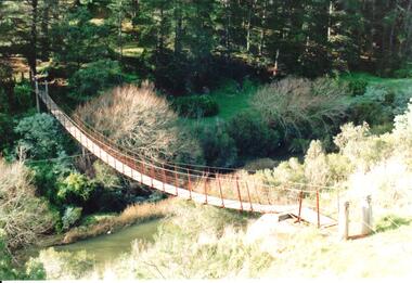
The original swing bridge was built across the Deep Creek in 1854 to allow the Daniel family to visit the Dickens sisters. It was renewed in later years and was used by Bulla children until the school closed in 1995.A coloured photograph of the swing bridge which straddles the Deep Creek at Bulla. The photograph shows the full length of the wooden and wire bridge from bank to bank. There is a thick row of conifers growing along the opposite river bank.bulla swing bridge, deep creek, daniel family, bulla state school, george evans collection -
 Hume City Civic Collection
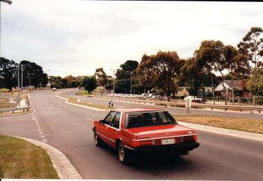
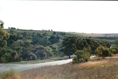
Photograph, Late 1990's
Riddell Road is the continuation of Macedon Street and is on the west side of the town centre. It is the main road to Riddells Creek, the Sunbury airstrip, Sunbury tip and water towers.A coloured photograph of Riddell Road looking west. A red car is in the foreground travelling north and is at the T intersection of Riddell Road and Ligar Street. There are houses along the north side of Riddell Road and the football ground is on the south side of the road.sunbury football club, riddell road, ligar street, george evans collection -
 Hume City Civic Collection
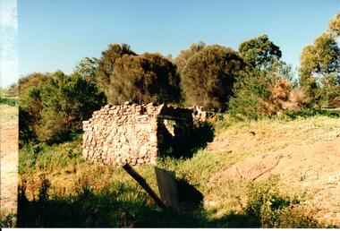
Photograph, Late 1980's
The Millbrook ruins are on a property which was created by John Pascoe Fawkner's Victoria Co-operative Freehold Land Investment Society. The aims of the company were to provide smallholdings to poorer settlers who wanted to farm. The ruins are now part of the Organ Pipes Park.A coloured photograph of stone ruins built on a hillside with sheoaks and other vegetation behind it. There is a doorway at the end of the small building.fawkner, john pascoe, millbrook ruin, jacksons creek, organ pipes park, victorian co-operative freehold land investment society, george evans collection -
 Hume City Civic Collection
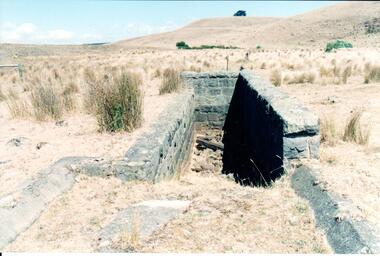
Photograph, Early 1990's
This is a photograph of one of the many stone ruins which can be seen in the Sunbury area and surrounding districts. These ruins are found in varying degrees of structural damage caused by erosion, vegetation growth and vandalism. The bluestone structure was a sheep dip on the 'Karoora Park' property near Jacksons Creek.A coloured photograph of the stone remains of a sheep dip constructed from basalt rock. The ground at the entrance slopes down into a narrow walled channel. The surrounding paddocks are covered with tussocks of grass and there are bare hills in the background. The grass is brown.stone structures, sheep dips, basalt rock, 'karoora park', george evans collection -
 Hume City Civic Collection
Photograph, Early 1990's
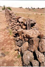
This is a photograph of one of the many stone ruins which can be seen in the Sunbury area and surrounding districts. These ruins are found in varying degrees of structural damage caused by erosion, vegetation growth and vandalism. The remains of the post and stone fence can be seen near Emu Creek at Bulla.A coloured photograph of the remains of a low post and stone fence in a sunburnt paddock. There are a few low growing bushes dotted across the paddocks.stone structures, dry stone walls, post and stone fences, george evans collection -
 Hume City Civic Collection
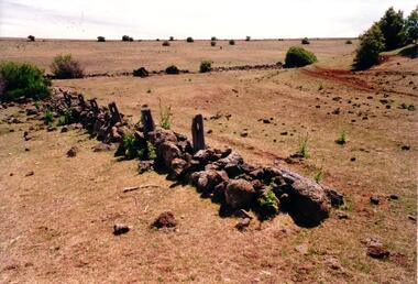
Photograph, Early 1990's
This is a photograph of one of the many stone ruins which can be seen in the Sunbury area and surrounding districts. These ruins are found in varying degrees of structural damage caused by erosion, vegetation growth and vandalism. The post and stone fence at Emu Creek at Bulla is more intact in this photograph.A coloured photograph of a post and stone fence surrounded by sun drenched paddocks.stone structures, post and stone fences, emu creek, george evans collection -
 Hume City Civic Collection
Photograph, c Early 1990's
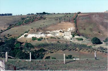
The Kaolin quarries at Bulla were an important industry in the district and supplied clay products to the Cornwell and Hoffman companies in Brunswick. The Kaolin deposits were found in the 1850's and were considered to be some of the largest in the colony.A landscape photograph of a valley with a post and wire fence and a partial view of a farm gate in the immediate foreground. A clump of native trees are on the LHS and a small grove of almond trees has been planted on the river flat. Kaolin quarry is on the hillside and two buildings can be seen on the hill top. High tension pylons are in the distance near the skyline.kaolin quarries, almond groves, bulla township, deep creek, hoffmans kaolin mine, hoffmans potteries, cornwell potteries, george evans collection -
 Hume City Civic Collection
Photograph, c 1980s
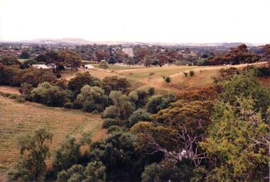
The photograph although recently taken shows the original settled area in Sunbury, which included Goonawarra Vineyard and Macedon Street which was once the business centre of Sunbury township before the railway was established.A coloured photograph of Sunbury Township looking west from above Jacksons Creek and Goonawarra Winery. Macedon Street can be seen in the middle distance and Mt. Holden and Burke Hill are across the skyline.sunbury township, mt. holden, burke hill, francis, james goodall, barnier, john, jacksons creek, goonawarra winery, george evans collection -
 Hume City Civic Collection
Photograph
Lochton was owned by William Morris Hunter who built and established the three storey flour mill on the horseshoe bend near Deep Creek in Bulla in the mid 1850s. The mill was steam driven. Since the 1960s when the Boral Company acquired Lochton, the property was leased out until January 1994.A coloured photograph of a former bluestone flour mill on a horseshoe bend of the Deep Creek. Trees are growing along the banks of the creek and sparsely covered hills are along the skyline.flour mills, hunter, william morris, lochton flour mill, deep creek, boral company, george evans collection -
 Hume City Civic Collection
Photograph, c late 1980s
The photograph shows a section of the original settlement of the Bulla township. The cutting on the hillside is significant as it is the remains of one of the original stream crossings in Victoria.A coloured photograph of the Bulla Hill along Sunbury Road with a view of the cutting on the distant hillside. The photograph is a view of the old Bulla township looking to the NW. There is a wide grassy verge in the foreground.bulla township, deep creek, wright, william 'tulip', sunbury road, george evans collection -
 Hume City Civic Collection
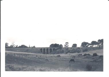
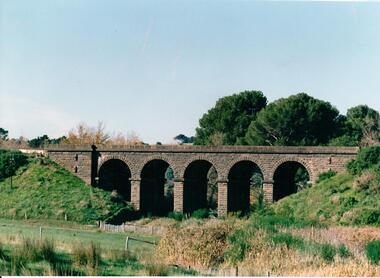
Photograph, pre 1970
The five arch bridge spans Blind Creek in Sunbury. The bridge is at the start of one of the longest and steepest inclines on a railway track in Australia.A black and white photograph of the 5 arch railway bridge and surrounding open area near Rupertswood. The tower of Ruppertswood can be seen in the distance.railway bridges, rupertswood, bridges, george evans collection -
 Hume City Civic Collection
Photograph, c late 1980s
The series of photographs show a number of sites included in the Rupertswood Estate. By 1851 William Clarke had acquired 31,375 acres of land in the Sunbury district. The foundation stone for Rupertswood Mansion was laid on 29th August 1874 by Mrs. W. J. Clarke, daughter-in-law of 'Big Bull'. The Salesian Fathers bought the Rupertswood property in June 1927 and established Salesian College.A coloured photograph of the bluestone and iron rail bridge over the Jacksons Creek on the Rupertswood Estate. One stone pylon at the top of the embankment and an iron pylon are visible along with the stone wall at the base of the embankment and part of the iron span. A post and wire fence is in the foreground.rupertswood estate, clarke, william j. t. 'big bull', salesian brothers, george evans collection -
 Hume City Civic Collection
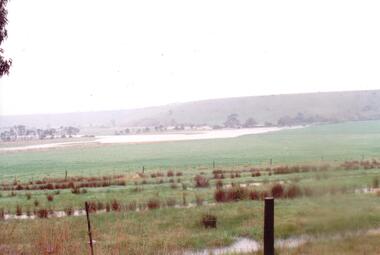
Photograph
The series of photographs were taken after exceptional heavy rain had fallen in Sunbury in the early 1990s. The Jackson Creek overflowed its banks and the surrounding flood plain area was under water.A coloured photograph of the Jackson Creek in flood along a river flat within the Rupertswood Estate. There are bare hills in the background and a fenced off run in the foreground.floods, weather patterns, jacksons creek, george evans collection -
 Hume City Civic Collection
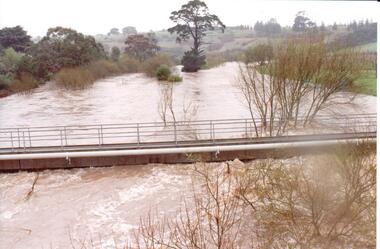
Photograph
The series of photographs were taken after exceptional heavy rain had fallen in Sunbury in the early 1990s. Jackson's Creek overflowed its banks and the surrounding flood plain area was under water.A coloured photograph of Jackson's Creek in flood taken near the footbridge in Macedon Street. The Nook area and Goonawarra Vineyard are in the background.floods, weather patterns, jacksons creek, george evans collection -
 Hume City Civic Collection
Photograph
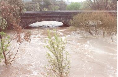
The series of photographs were taken after exceptional heavy rain had fallen in Sunbury in the early 1990s. Jackson's Creek overflowed its banks and the surrounding flood plain area was under water.A coloured photograph of Jackson's Creek in flood. The floodwaters have almost reached the top of the arch of the Macedon Street stone bridge.floods, weather patterns, jacksons creek, george evans collection -
 Hume City Civic Collection
Photograph, late 1980s
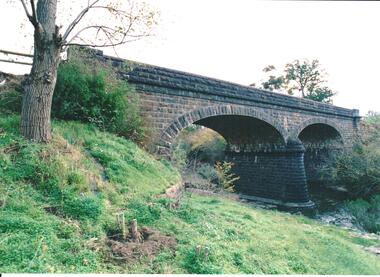
The road bridge over Jackson's Creek in Sunbury was built in 1870 and was in use until a wider bridge was built when Sunbury Road was rebuilt in the early 1970s.A coloured photograph taken from the NE side of the river bank of a complete view of the bluestone bridge at Macedon Street. The two eliptical arches and the protruding pylon as well as the underside of the bluestone span are clearly visible.transport, roads and bridges, jacksons creek, harris, thomas lascelles, george evans collection -
 Hume City Civic Collection
Photograph, 1980s
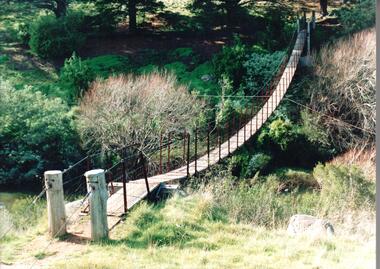
The timber and cable swing bridge straddled the Deep Creek at Bulla behind the Bulla school. It enabled children who lived across the river to travel directly to school instead of going the long way around the road, a possible distance of 2-3 kms.A coloured photograph of the timber and cable swing bridge which was constructed across the Deep Creek at Bulla. Trees are growing along the river bank and there is a row of conifers growing along the opposite bank.swing bridges, deep creek, george evans collection -
 Hume City Civic Collection
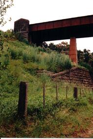
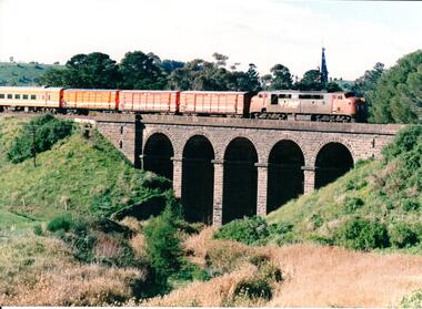
Photograph, late 1980s
The five span masonry arch bridge over Blind Creek was one of the major constructions on the Melbourne to Echuca Railway. It was one of the first masonry rail bridges built in Victoria. Construction began in 1859 when the railway was extended from Sunbury and was designed by G C Darbyshire.A coloured photograph of the 5 arched bluestone rail bridge showing the grassy embankments on each side of the bridge and the creek flat at the base of the bridge. Some tree tops are visible on the other side of the bridge.bridges, transport, rail transport, darbyshire, g. c., blind creek, v line, george evans collection -
 Hume City Civic Collection
Photograph, late 1980s
The five span masonry arch bridge over Blind Creek was one of the major constructions on the Melbourne to Echuca Railway. It was one of the first masonry rail bridges built in Victoria. Construction began in 1859 when the railway was extended from Sunbury and was designed by G C Darbyshire.A coloured photograph of the 5 arched bluestone rail bridge over Blind Creek with the embankments on either side and the tower of Rupertswood Mansion in the distance. A VLine diesel engine along with 3 goods carriages and a passenger carriage is on the bridge.bridges, transport, rail transport, darbyshire, g. c., blind creek, v line, george evans collection -
 Hume City Civic Collection
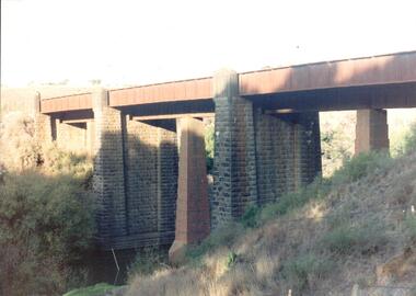
Photograph, late 1990s
The bridge constructed from bluestone, brick and iron over the Jacksons Creek at Sunbury is an important structure on the Melbourne-Echuca rail line. The foundation stone for the bridge was laid on 13 January 1859 and the bridge opened in July 1861. It is of state significance.A coloured photograph of the bluestone and iron railway bridge which is ove the Jacksons Creek. The bridge has 3 bluestone pylons and three iron pylons with 3 sections of the iron spans visible across the top.transport, bridges, rail transport, darbyshire, g. c., jacksons creek, george evans collection -
 Hume City Civic Collection
Photograph, late 1980s
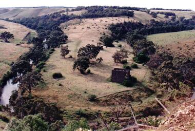
This is a photograph of the site and the remains of the Lochton flour mill which was situated on a horse shoe bend along Deep Creek at Bulla. Captain William Morrison Hunter took up land along Deep Creek and built his home in 1850.He opened the flour mill in 1856, which was worked by a number of millers until it ceased operations in 1961.Flour milling was one of the early industries carried out in the Sunbury and Bulla district. The mills were established along Jacksons Creek in Sunbury and Deep Creek in Bulla.A coloured photograph of a tree lined horseshoe bend in a river with the remains of a bluestone building in the bottom RH corner.lochton flour mill, bulla, flour mills, captain william morrison hunter -
 Hume City Civic Collection
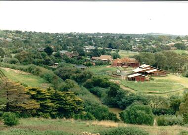
Photograph
Housing development spread to the banks of the Jacksons Creek at the east end of the town in the late 1970s.A coloured landscape photograph overlooking the Jacksons Creek and Sunbury township and showing housing development which is taking place on the horse shore bend also known as blueberry island on the opposite creek bank.jacksons creek, blueberry island, george evans collection -
 Hume City Civic Collection
Photograph, c 1990s
Canon Gully is situated about 2 km upstream from the railway bridge at Rupertswood. In 1864 it was the site for the military encampment of the Victorian Volunteer Forces. William Clarke allowed the military to stage the annual event on his property. Further encampments were held on this site in 1874 and 1877.A coloured photograph of a wide valley with cleared hills in the background. The tree lined creek or watercourse is across the middle distance of the image.canon gully, rupertswood estate, encampments, clarke, william j. t. 'big bull', victorian volunteer forces, george evans collection -
 Hume City Civic Collection
Photograph, early 1980s
The photograph shows the extent of Sunbury's development to the west of the town in the early 1980s. The settlement at this stage extended along either side of Gap Road for about 0.5 km beyond Elizabeth Drive.A coloured landscape photograph with rounded corners taken from Mt. Holden and looking towards the expanding town of Sunbury. The Melba Avenue drain which flows into Blind Creek is in the foreground. Sheoak Hill, the site of the former Sunbury Asylum is in the middle of the skyline.sunbury township, reservoir road, mt. holden, sunbury asylum, george evans collection -
 Hume City Civic Collection
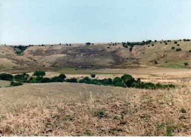
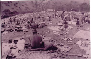
Photograph, 1/01/1972
Three pop festivals were staged in Sunbury. One in 1972 and a further ones in 1974 and 1975 . The 1972 festival was the most famous and followed on in the Woodstock tradition. The festivals were staged on a property on the banks of the Jacksons Creek, owned by the Duncan family. A crowd of partly clad people sitting or lying on the ground in a wide valley listening to a performance can be seen in the image. The area is litterred with cans, eskies, blankets, sleeping bags and tents. A stage is in the background.A photograph of the 1972 Sunbury Pop Festival.sunbury pop festival, jacksons creek, duncan, george, george evans collection -
 Hume City Civic Collection
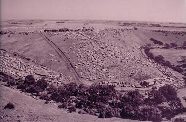
Photograph, 1972
The photograph was taken during the 1972 Sunbury Pop Festival which was staged on a property owned by George Duncan. The site is on the banks of the Jacksons Creek between Sunbury and Diggers Rest.An aerial photograph of a crowd of people on a hillside and along a creek valley with a stage set up. On the LHS there is a large marquee surrounded by cars and pitched tents. There are trees around the creek and vast open paddocks in the distance.sunbury pop festival, jacksons creek, duncan, george, george evans collection