Showing 2061 items matching "crossings"
-
 Ballarat Tramway Museum
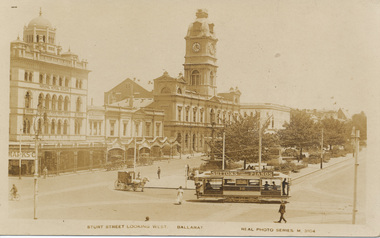
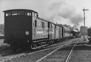
Photograph - Digital image, c1921
Yields information the buildings, buildings and scene at the intersection of Sturt and Lydiard St with a tram crossing the road.Digital image from the Wal Jack Ballarat Album of a postcard - titled ""Sturt Street, Looking West, Ballarat" with ESCo tram No. 16 crossing from Sturt St south side (from Grenville St) into Lydiard St North. Has conductor on rear footstep. Appears to be taken on a hot day. Real Photo Series M 3104. Has a number of horse carts in the photograph. Tram has an advertisement for Suttons Pianos on the roof. Card produced by Valentines & Sons Publishing Co. Ltd. See rear of card for company location details. In the photo are advertisements or buildings for: National Mutual Building, Town Hall, and Marks & Co. Wal has dated the photo about 1921 in his album notes. For rear of postcard - see image i2.trams, tramways, esco, sturt st, lydiard st, town hall, tram 16 -
 Ballarat Tramway Museum
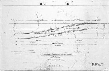
Drawing - Brisbane City Council Tramway Trackwork drawings
Prepared by the City of Brisbane for the design of trackworkYields information on the design of trackwork.Set of nine City of Brisbane Tram Track drawings .1 - PPW91 - Standard Crossover left hand - 4'6" between tracks .2 - PPW2450 - Data for British Standard Crossings .3 - PPW 241 - Data for British Standard Lateral Switches .4 - PPW 463 - Concrete Track Construction is 102.73lb rail. .5 - PPW 501 - ditto for AS 82lb rail and other rails .6 - Not numbered - Concrete roads when using T rail sleepers .7 - PPW 575 - 150' radius RH crossover - 5' between tracks .8 - PPW 576 - 150' radius RH Crossover - 4'6" between tracks .9 - PPW 577 - 150' radius LH Crossover - 5' between tracks - 14/12/1948trackwork, points, switches, bcc transport, tramways -
 Charlton Golden Grains Museum Inc
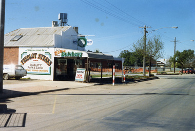
Photograph, Charlton Shire, Turner's Butcher Shop, Hight St Charlton, c.1987
Part of a Shire streetscape series of photos c. 1987Colour photograph of Turner's Butcher Shop on the corner of Learmonth and High Streets. Sign above the verandah reads Turners Butchery and has a picture of a ram's head between the two words. The signage on side of building reads Specialising in FEEDLOT STEAKS, QUALITY Pork & Lamb, Friendly Service. Deliveries. The sign on the side of the bullnose verandah reads TURNERS Butchery Phone 911506. A sandwich board in front of the shop on the edge of the footpath reads Butcher NOW OPEN. A white station wagon is parked in the yard beside the shop. There are two red and white school crossing posts on the rod in front of the shop. A building is under construction in the block across the road and there is orange safety fencing around the front of the block. The mill silos are visible behind the butcher shop.turner's butcher shop, high st charlton, learmonth st charlton, business -
 Ballarat Tramway Museum
Slide - 35mm slide/s set of 16, John Theodore, Dec 74/Jan 75
Yields information about the early operations in Wendouree Parade prior to the official opening.Set of 16 AGFA blue and white plastic mount 35mm slides of early running on Wendouree Parade - late December 1974, January 1975. .1 - 26? at Gardens Loop with Peter Winspur and Barry McCandlish walking in front of the tram. .2 - 26 at Gardens Loop .3 - 26 and 40 at Gardens Loop .4 - ditto .5 - 26 at Carlton St .6 - 26, side on view, Wendouree Parade .7 - 40 at Wendouree Parade .8 - ditto near Depot Junction .9 - ditto .10 - 40 at Depot Junction .11 - 26 at Depot Junction .12 - 40 at Depot Junction .13 - 26 crossing Wendouree Parade at Depot Junction .14 - ditto .15 - 26 on the access track .16 - 26 and 40 at Gardens Loop Various notations by John as to the slide number and the trams in pencil and ink.tramways, trams, btps, commissioning, wendouree parade, st aidans drive, gardens loop, depot junction, carlton st, tram 40, tram 26 -
 Melbourne Tram Museum
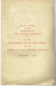
Document - Report, Metropolitan Town Planning Commission, "Metropolitan Town Planning Commission - Darling to Glen Waverley Railway - 1927", May. 1927
Report - 20 pages + 5 Maps stapled and then glued bound within a light green grey light card folder titled "Metropolitan Town Planning Commission - Special Report on the Development of the area serviced by the Darling to Glen Waverley Railway - 1927". Report looks the development that could be undertaken along the proposed Glen Waverley rail line, its town planning, Garden City type layouts, rail level crossings, new arterial roads, open spaces, financial arrangements, sewerage and water supply, zoning, legislation and conclusion. Dated 6/5/1927. Plans show possible garden city type layouts, arterial roads, possibilities within existing sub-divisions. Note that Mr. Strickland was a member of the Commission undertaking this work.Has in ink on the bottom edge "17th June 1919"trams, tramways, mmtb, tramways, development, town planning, glen waverley, darling -
 Melbourne Tram Museum
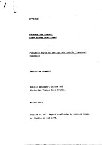
Document - Report, Public Transport Unions and Victorian Trades Hall Council, "Upgrade the Trains, Keep Sydney Road Trams - Position Paper on the Upfield Public Transport Corridor", Mar. 1989
1586 - Photocopy - report - 9 A4 sheets stapled in the top left hand corner, titled "Upgrade the Trains, Keep Sydney Road Trams - Position Paper on the Upfield Public Transport Corridor - Executive Summary", setting out the Union view of the conversion of the Upfield line to light rail. Notes the issues with the project, experience on the conversion of the St Kilda and Port Melbourne lines, level crossings and staffing. 1586.1 - as above but the full report - 66 pages, stapled along the side with clear plastic front, white card rear cover with a table of contents, including notes on the North-South rail (St Kilda and Port Melbourne) - experience to date, critique on The Met's Upfield line study, the Union's preferred option, Benefits of preferred option and the role of light rail, appendices and recommendations.trams, tramways, upfield light rail, sydney rd, unions, light rail -
 Melbourne Tram Museum
Slide, Keith Caldwell, 12/03/1960 12:00:00 AM
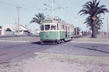
Agfa Colour slide, cardboard mount, by Keith Caldwell dated 12 March 1960, of W5 818 running in Mount Alexander Road, North Essendon, crossing the street access for Marco Polo Street. The tram showing route 59, Essendon Aerodrome, has trolley wheels and has a second person in the cab, possibly a trainer. Unusually the tram number is placed above the headlight, In the background are the palm trees in the centre median plantation. The house with the red guttering is one that dates back to the gold mining era. See http://www.esshissoc.org.au/1070%20Mount%20Alexander%20Road.pdf It was relocated to Woodland Park during 2017? Note the Centre poles, overhead construction and street light. Also in the background is a Mobil Service station that later became a garden centre. Now a block of apartments.hand stamped "12 Mar '60"trams, tramways, mount alexander rd, north essendon, essendon airport, essendon aerodrome, route 59, w5 class, tram 818 -
 Melbourne Tram Museum
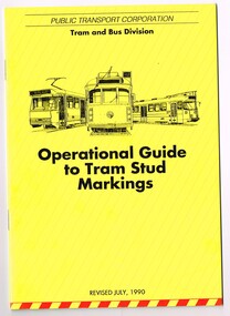
Document - Instruction, Public Transport Corporation (PTC), "Operational Guide to Tram Stud Markings", Jul. 1990
Set of two documents involved with stud markings in the roadways for Melbourne tramway operations. .1 - A5 size centre stapled document, 16 pages on white paper plus colour, printed yellow with sketches of a B, W and Z class trams, titled "Operational Guide to Tram Stud Markings". Published by the PTC July 1990. Gives information to drivers on types of studs at facing points, cross overs, shunts, clearance markings, section insulations, H crossings, T light, depot yards, compulsory stops. Has diagrams, and provides details for various classes of trams. 2nd copy added 6-1-2018. .2 - folded A4 sheet printed on gloss white paper, with the same sketch of trams on the top, titled "Summary of Changes and additions to stud markings", published by the PTC.trams, tramways, ptc, tramways, stud marking, drivers, instructions -
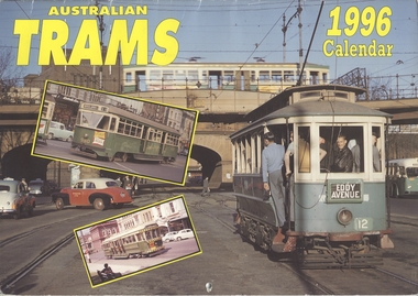 Melbourne Tram Museum
Ephemera - Calendar, Topmill Pty Ltd, "Australian Trams - 1996 Calendar", 1995
Wall Calendar - heavy card covers, 12 gloss art pages inside, titled "Australian Trams - 1996 Calendar" containing cull colour photographs of Sydney, Adelaide, Bendigo, Ballarat, Melbourne, Fremantle 29 and Victor Harbor. Has a punched hole along the top edge to enable wall use. Provides dates for holidays, school holidays and Pension payment days and phases of the moon. Produced by Topmill Pty Ltd and distributed by Gordon & Gotch Pty Ltd. All Photos by Dr D. Ellerton. Features large format photos of 672 crossing the wooden Maribyrnong River Bridge, 672, 671, 980, X2 676, X 217, VR 52, S164 Second copy from AETA collection added 17/1/1014.trams, tramways, ballarat, bendigo, melbourne, adelaide, sydney, tram 672, tram 671, tram 980, tram 217, tram 52, tram 164 -
 Orbost & District Historical Society
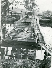
black and white photograph, 1971
This photograph shows the second major bridge across the Snowy River at Orbost. The current Snowy River bridge is the fourth to provide a crossing to the township of Orbost. The first, in 1891, lasted just two years before it succumbed to flood waters. The bridge in this photograph was built in the 1920s as a road and rail bridge, and was again partly washed away by flood waters in 1934. After the end of the first World War the Victorian Railways considered an extension of the railhead across the river at Orbost, and in 1922 a new timber and steel girder structure, a joint Country Roads Board — Victorian Railways venture, was built and completed at a cost of £41,000 (the steel girders came from the Flinders Street viaduct reconstruction). Subsequently it was decided not to take the railway across the river, and the bridge was only used by road traffic. It was severely battered by floods during its life. and after the devastating 1971 floods was eventually replaced by the current bridge in 1975. (info from Newletter 54N by John Phillips)This is a pictorial record of the flood damage in 1971 when part of the Snowy River Bridge was washed away.A black / white photograph of a bridge which has been damaged by floodwaters. It shows one end has been washed away.orbost-snowy-river-bridge-1971 floods-orbost-1971 -
 Eltham District Historical Society Inc
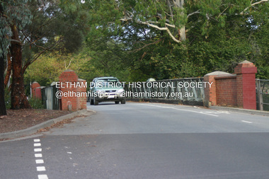
Photograph - Digital Photograph, Alan King, The Diamond Creek Bridge, 30 March 2008
Old Bridge on Main Hurstbridge road in Diamond Creek township crossing the Diamond Creek. The bridge opened in April 1898. Evelyn Observer, and South and East Bourke Record (Vic. : 1882 - 1902), Friday 22 April 1898, page 2 "Diamond Creek Bridge. The official opening of this bridge took place yesterday (Thursday) in the presence of a large gathering of people. The bridge-a substantial iron structure, costing .~r 2oo-was profusely decorated with "flags of all nations" for the occasion. In the absence of the Minister' of Public Works-who was unavoidably prevented from attending-the opening ceremony was neatly performed by President Lugton, of the Heidelberg Shire, in a few wellchosen words, after which an adjournment was made to the Literary Institute, where some sixty gentlemen were entertained at luncheon, followed by speeches, songs, and recitations. It was a red letter day for the Creek, and everything passed off with becoming eclat." Published: Nillumbik Now and Then / Marguerite Marshall 2008; photographs Alan King with Marguerite Marshall.; p7This collection of almost 130 photos about places and people within the Shire of Nillumbik, an urban and rural municipality in Melbourne's north, contributes to an understanding of the history of the Shire. Published in 2008 immediately prior to the Black Saturday bushfires of February 7, 2009, it documents sites that were impacted, and in some cases destroyed by the fires. It includes photographs taken especially for the publication, creating a unique time capsule representing the Shire in the early 21st century. It remains the most recent comprehenesive publication devoted to the Shire's history connecting local residents to the past. nillumbik now and then (marshall-king) collection, diamond creek, diamond creek bridge, main hurstbridge road -
 Eltham District Historical Society Inc
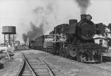
Photograph, George Coop, Steam locomotive J-502 hauling a specialist plant track repair and goods recovery train departing Echuca, Aug. 1963
A special plant track repair and goods recovery train proceeding to a cattle train derailment on the Balranald (NSW) line from which sheep had also escaped. The train composition was made up of J-Class steam locomtive J-502, a water gin carrying extra water for the train given doubtful supplies en-route, a wagon to reload the surviving sheep, a wagon containing track tools and equipment, a carriage for the work crew, a bogie wagon containing all the specialist tools for re-railing the train, followed lastly by the Guard's van. The specialist wagons and their equipment were based at the Bendigo Depot (see painted markings on van side) in a state of readiness for immediate use as the need arose The train is viewed approaching the Iron Bridge grade out of the Echuca rail yard. The Gatekeepers hut is visible on the right. The gatekeeper would be notified of the approaching train at which time he would open the gate to allow the train to pass through the Packenham Street level crossing.Digital TIFF file Scan of black and white print Enlargement prints on textured paper (15.5 x 20.5 cm)george coop collection, echuca, j-502, j-class steam locomotive (vulcan foundry) -
 Eltham District Historical Society Inc
Photograph, George Coop, Steam locomotive J-502 hauling a specialist plant track repair and goods recovery train departing Echuca, Aug. 1963
A special plant track repair and goods recovery train proceeding to a cattle train derailment on the Balranald (NSW) line from which sheep had also escaped. The train composition was made up of J-Class steam locomtive J-502, a water gin carrying extra water for the train given doubtful supplies en-route, a wagon to reload the surviving sheep, a wagon containing track tools and equipment, a carriage for the work crew, a bogie wagon containing all the specialist tools for re-railing the train, followed lastly by the Guard's van. The specialist wagons and their equipment were based at the Bendigo Depot (see painted markings on van side) in a state of readiness for immediate use as the need arose The train is viewed approaching the Iron Bridge grade out of the Echuca rail yard. The Gatekeepers hut is visible on the right. The gatekeeper would be notified of the approaching train at which time he would open the gate to allow the train to pass through the Packenham Street level crossing.Digital TIFF file Scan of black and white print Enlargement prints on textured paper (15.5 x 20.5 cm)george coop collection, echuca, j-502, j-class steam locomotive (vulcan foundry) -
 City of Ballarat
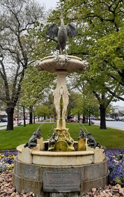
Artwork, other - Public Artwork, Petersen Fountain, 1922
This fountain was created as the result of a bequest from Ballarat businessman Carsten Heinrich Petersen who was killed at the age of eighty-five years when crossing Sturt Street opposite the Base Hospital. On the other side of the street were three brick shops which he owned. The fountain has four bronze frog water spouts beneath four marble stork spouts. Above the top bowl is another stork in bronze with its wings spread and water issues from its outstretched beak. The Petersen Fountain has been restored many times, first in 1977 with funds provided by the Rotary Club of Ballarat South. In 1989 further restoration works were completed to replace bronze frogs and a brass and copper stork made by Ballarat craftsman Lloyd Lusk to replace the original bird which was stolen and never recovered. The second stork was also stolen on the 3rd of August 1983 and further repairs of the fountain were carried out in 1993. The artwork is of historical and aesthetic significance to the people of Ballarat. The Petersen Fountain is carved marble, features storks carved into its base and the faces of cherubs in the bowl. It has a copper crane perched at the top and bronze frogs surrounding that spray water. The fountain stands on a granite base. PRESENTED/ BY/ C.H. PETERSEN/ BORN IN DENMARK 2nd MARCH 1836/ DIED BALLAARAT 9 FEBRUARY 1922petersen fountain -
 Glen Eira City Council History and Heritage Collection
Document (Item) - Newspaper (digital), Caulfield Contact
The Caulfield Contact was the official newspaper of the City of Caulfield from 1976-1994. The City of Caulfield was the Municipal Council for an area of the South Eastern suburbs of Melbourne, including Brighton East, Carnegie, Caulfield, Elsternwick, Gardenvale, Glen Huntly, McKinnon, Murrumbeena, Ormond and St Kilda East. Following Amalgamation of City of Caulfield and parts of the City of Moorabbin in 1994, the Caulfield Contact was followed by the Glen Eira News. Includes references to the following: Children's Neighbourhood Centre Caulfield; Fire destroyed Caulfield Park Bowling Club; Naming of Harleston Park; Home Handyman Service; Profiles Councillors Peter Baitz, Ron Walters; Carnegie-Glenhuntly Football Club formed Council drops approval of rail crossings over Neerim and Glenhuntly Roads; Profiles Councillor Alwyn Samuel, Glen Richards; First stage of Nepean Highway widening; Minister approved re-subdivision; Council spills; Exciting development of Caulfield Park; Profiles Councillor Max Blair, Councillor Brian Rudzki; Tram shelter classified by National Trustcity of caulfield, caulfield, glen eira, city of glen eira, caulfield contact, children's neighbourhood centre caulfield, fire destroyed caulfield park bowling club, naming of harleston park, home handyman service, profiles councillors peter baitz, ron walters, carnegie-glenhuntly football club formed, council drops approval of rail crossings over neerim and glenhuntly roads, profiles councillor alwyn samuel, glen richards, first stage of nepean highway widening, minister approved re-subdivision, council spills, exciting development of caulfield park, profiles councillor max blair, councillor brian rudzki, tram shelter classified by national trust -
 Vision Australia
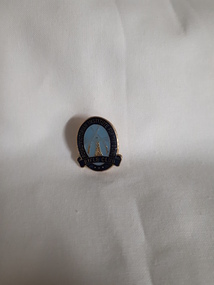
Badge - Object, RVIB Rifle Club badge
This badge has 'Royal Victorian Institute for the Blind' written in gold against a dark blue background around an oval shape, with the words 'Rifle Club' in the same lettering at the base. Inside the oval, on a light blue background, is a lighthouse and a rifle either side of it, the butts crossing at the apex. In the 1960's, the RVIB approached engineer George Glover to produce equipment to allow blind people to shoot, based upon that made available at St Dunstan's Hospital in the UK. The rifle range opened in February 1966 at the rear of St Kilda Road with 30 members, and soon became involved in matches with sighted rifle clubs in the area. The club had many successful years, competing against teams from Canada and New Zealand in 1968, and had the support of ICIANZ which provided them with free munitions as well as teams to compete against. In 1977, George Glover passed away and some of the skills required for maintenance of the equipment was lost, however the club continued until the late 1980's/early 1990s.Lighthouse with two rifles either side and crossed at top on blue backgroundRoyal Victorian Institute for the Blind Rifle Clubroyal victorian institute for the blind, badges, rvib rifle club -
 Ballarat Tramway Museum
Photograph - Colour Photograph/s, 23/11/1962 12:00:00 AM
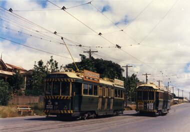
967.1 - Colour postcard size print of SEC Bendigo trams 4 and 17 at a crossing Loop on the Eaglehawk line. Photo dated 21.11.1962. Printed on AGFA paper. Both trams fitted with dash canopy lighting, but no large white strip under the driver's windows. 17 showing destination of "Eaglehawk", has two SEC ads on the side re Electric Cook and a White Horse whiskey ad on front panel. Tram 4 showing destination of "Quarry Hill", has two ad panels on roof and two ads on front panel including one Cohn's' Drinks. 967.2 - Colour postcard size print of SEC Bendigo tram 26 in Mitchell St. crossing Hargreaves St. heading for Charing Cross. Photo dated 21.11.1962. Printed on AGFA paper. Trams fitted with dash canopy lighting, but no large white strip under the driver's windows. Has two roof ads and one ad on rear drivers panel. In background of photo are the buildings along Mitchell St. looking down along Mitchell St and into View St. Has Plaza theatre sign in photo above tram. On right hand side, is a van marked "Carrier M. Slattery". Tram has destination of "Quarry Hill" in rear box. 967.3 - Colour postcard size print of SEC Bendigo tram 19 on the North Bendigo line. Photo dated 21.11.1962. Printed on AGFA paper. Trams fitted with dash canopy lighting, but no large white strip under the driver's windows. Has destination "Nth Bendigo" and SEC roof ads and drivers panel ad for Briquettes.On rear top left hand corner "21.11.62" in very wavy handwriting typical of an aged person.bendigo, eaglehawk, mitchell st., north bendigo, tram 4, tram 17, tram 26, tram 19 -
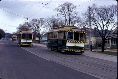 Ballarat Tramway Museum
Photograph - Digital image Set of 8, 21/08/1971 12:00:00 AM
Yields information about the SEC Ballarat trams in the months before the closure of the SEC Tramway system. Yields information about the streetscape. Set of 8 Digital images, scanned from slides by Graeme Cleak, scanning by Peter Winspur 9/2011. .1 - Slide FS14 - No. 31 and 32 crossing at the High St Loop in Macarthur St. Tram 31 has the destination of Victoria St. Geoff Dean and his mini on the right hand side of the photograph. Another depot bound single trucker in the photograph, .2 - Slide FS3 - 31 outbound in Victoria St, with St Alipius church in the background. .3 - Slide FS5 - No. 31, and four other trams, some running special at Sturt and Lydiard Sts during the ARHS tour of that day. Has the ANZ Bank and SEC offices in the background. .4 - Slide FS9 - Nos. 39, 26 and two other trams in Lydiard St for the ARHS tour with Reid's Palace, Macleod & Co and J.J. Collier buildings in the background along with other buildings in Lydiard St North. Taken from the Provincial Hotel. .5 - Slide FS11 - No. 26 northbound showing Special running through the level crossing at Ballarat with the Kennedy Murray General Carrier in the background. Taken from the Provincial Hotel. .6 - Slide FS13 - No. 32 turning from Sturt St into Drummond Street North showing Depot via Drummond North, with the Southern Cross Hotel, Rimmington Bros and J.A, Malpass(?) buildings in the background. .7 - Slide FR35 - night shot of No. 17 (with Twin Lakes sign) and No. 32 in Nos 3 and 4 roads at the depot. .8 - Slide FR34 - night shot of the front of the depot - as above and No. 43 on "0" road. All photos 21-8-1971 trams, tramways, railway station, macarthur st, victoria st, sturt st, lydiard st north, level crossings, depot, tram 31, tram 32, tram 39, tram 26, tram 17, tram 43 -
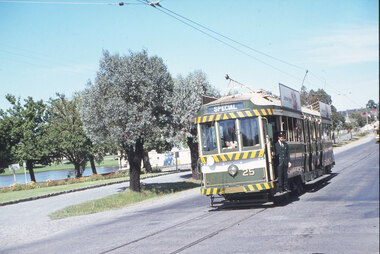 Ballarat Tramway Museum
Slide - 35mm slide/s - set of 20, Eldon Hogan, 22/05/1971 12:00:00 AM
Set of 20 35mm Agfa colour blue and white plastic mount slide - featuring photos taken during an Association of Railway Enthusiasts Tour by Eldon Hogan. Folder had the date "22/5/1971" on it. Scanned on the Canon scanner at the depot 15/12/2005 at the time of the installation of the scanner. .1 - No. 25 in Nolan St with Lake Weeroona in the background. .2 - Three Birneys at the Depot junction, 30 and 29 with Conoles Hotel, McCrae St in the background. .3 - No. 5 in front of the Shamrock Hotel, Pall Mall .4 - No. 29 in front of the Shamrock Hotel with Stonemasons sign in the background. .5 - No. 18 ditto .6 - No. 30 and another Birney at the Quarry Hill terminus .7 - No. 24 southbound High St at the Violet St intersection with a "Mine Open" sign in the foreground and the Cathedral in the background. .8 - No. 19 at the Golden Square terminus, with the Golden Square Hotel in the background. .9 - No. 29 - side on view, North Bendigo line? Thunder St? .10 - No. 30 crossing the railway overbridge, inbound from Eaglehawk with a number of photographers in the foreground. .11 - No. 29? ditto .12 - No. 5 outbound - side on view, Thunder St, North Bendigo line? .13 - No. 29 and 30 at the intersection of High St and Brazier St with Church or School hall in the background. .14 - ditto .15 - ditto .16 - No. 25 and the two Birneys at the Eaglehawk terminus. .17 - No. 29 and two other trams at ditto .18 - No. 30 and 19 adjacent to the Lake View Hotel, McCrae St .19 - No. 5 and 25 crossing on the Eaglehawk Line, Ironbark? .20 - No. 29 at Quarry Hilltramways, trams, bendigo, lake weeroona, pall mall, golden square, eaglehawk, quarry hill, tram 25, tram 30, tram 29, tram 5, tram 18, tram 19, tram 24, tram 25 -
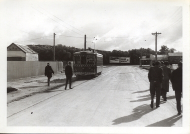 Ballarat Tramway Museum
Photograph - Black & White Photograph/s - set of 32, Eldon Hogan, 4/06/1965 12:00:00 AM
Yields information about a 1924 Jelbart Engine manufacturing display in Sturt St and the street scene and peoples clothing at the time.Set of 32 black and white photographs of an Association of Railway Enthusiasts tour to Bendigo and trams 4/7/1965. The photos are not necessarily in photographic order. .1 - 30 on the Eaglehawk terminal track, beyond the normal terminus. .2 - 30 & 29 High St Eaglehawk. .3 - ditto with a poppet head in the background. .4 - 30 at one of the crossing loops .5 - 30 at Eaglehawk terminus extension .6 - ditto. .7 - ditto .8 - cleaning out the track .9 - showing the location of the track at Eaglehawk terminus and its extension .10 - cleaning out track .11 - a portable shed adjacent to the track .12 - A view of the two Birneys travelling in the empty country. .13 - ditto .14 - 19 and 18 at Golden Square .15 - Bendigo tram depot - creek crossing .16 - Scrubber at the depot .17 - 28 and 19 at the North Bendigo terminus .18 - 18 and 30 on the Golden Sq line .19 - 28 and 19 at the North Bendigo terminus .20 - ditto. .21 - 28 and 19 near the depot entry. .22 - 28 and 30 Pall Mall .23 - 28 at North Bendigo .24 - 17 and 19 and 6 at Quarry Hill .25 - 28 and 30 Mitchell St .26 - 19, 6 and 21 Quarry Hill .27 - 19 and 6 Quarry Hill .28 - 28 and 6 at the depot entry .29 - ditto .30 - 18 and 30, Golden Sq line .31 - 25 at depot .32 - 6 and 19 Charing Cross. Photographer Eldon Hogan. Printed on Kodak Paper .33 - roll of negatives of some of the above photos - stored in box 83 as well. trams, tramways, are, bendigo, eaglehawk, quarry hill, golden square, north bendigo, tram 30, tram 29, tram 28, tram 6, tram 19, tram 25, tram 17, tram 18 -
 Eltham District Historical Society Inc
Photograph, Upper Yarra Dam, Spring Tour, 22 Oct 1995, 22/10/1995
EXPLORING THE UPPER YARRA (Newsletter No. 105, November 1995, by Bettina Woodburn) We enjoyed the Spring Excursion, this year "Exploring the Upper Yarra" - in spite of the constant rain and the countryside under the cloud cover, especially in the valleys, being mainly shiny shades of green. The occasional fields of buttercups, clumps of arum lilies and splendid rhododendron and other flowering bushes became very special. The Cobb and Co coach was warm and a cosy retreat as we zig-zagged on the highways and byways to glimpse the Yarra River, upstream and down, its secret places, and particularly the many bridges. Russell excelled as 'Poet Laureate', reading from Dacre Smyth's book. This 1979 publication includes paintings of all the bridges along the river with poems and brief descriptions of each one. Some of the bridges are in out of the way places and are not very well known. We looked forward to hearing the poetry as much as seeing the ' constructions'…Big Pat (was he short or tall, lean or fat? He did win the two hundred pound reward for discovering gold and had the creek named after him), about the 'Eddies'?, and the disliked 'meccano' bridge in Warburton, etc. etc. The hot roast lunch in the old Reefton Hotel was also most welcome. It was easy to imagine it peopled by miners and early settlers. Starting by crossing the new (1974) concrete bridge at Warrandyte we headed through Wonga Park with views to the Christmas Hills and to the escarpment of the Yering Gorge, which causes flood waters to back up through the Yarra Glen plain, so avoiding disasters downstream. At the end of a long driveway we found the wooden, privately owned Henley Bridge (1935 after the 1934 floods). This facilitates access to different parts of Henley Farm and to Lilydale. Everard Park, named after Blanche Shallard's father, a State Member for 17 years, below the Highway Yarra crossing was in need of care. It is 10 miles from Yarra Glen by road but, as "Yarra Marra” canoeists well know, 32 winding miles down by water. After more delightful countryside scenes we joined the Warburton Highway at Woori Yallock. From the old Railway Station at Launching Place the Centennial Trail for walkers, cyclists and ' horse riders has replaced the rails. The line from Lilydale was opened in 1901, and the last diesel freight train ran to Warburton in 1965. It continued to rain as we had morning tea in Warburton in a shelter between footbridges. From here we continued upstream past the Bridge to O'Shannasy Lodge and Reservoir, Starvation Creek, and the Peninsular tunnel (miners dug it as at Pound Bend) which we visited (scrambling down those steps!) on our return after lunch. Our furthermost point was the Upper Yarra Dam Reserve (and vast catchment area). Finished in 1957 after ten years work and 100 years after Yan Yean, it supplies much of Melbourne's water. After crossing the 30m Launching Place Bridge to the Eltham side of the Yarra and Healesville, we saw in the distance the Yarra Glen Timber Trestle Bridge over the river flats "the longest for years in the land it was said!" Harry's dream of "better weather over the Divide" unfortunately didn't come true, but I'm sure we 36 members will retain happy memories of a day that was wet and green and filled with Bridges. Bettina Woodburn - October 1995 Record of the Society's history of activities - Spring 1995 excursionColour photographshire of eltham historical society, activities, upper yarra dam, henley bridge -
 Eltham District Historical Society Inc
Photograph, Upper Yarra Dam, Spring Tour, 22 Oct 1995, 22/10/1995
EXPLORING THE UPPER YARRA (Newsletter No. 105, November 1995, by Bettina Woodburn) We enjoyed the Spring Excursion, this year "Exploring the Upper Yarra" - in spite of the constant rain and the countryside under the cloud cover, especially in the valleys, being mainly shiny shades of green. The occasional fields of buttercups, clumps of arum lilies and splendid rhododendron and other flowering bushes became very special. The Cobb and Co coach was warm and a cosy retreat as we zig-zagged on the highways and byways to glimpse the Yarra River, upstream and down, its secret places, and particularly the many bridges. Russell excelled as 'Poet Laureate', reading from Dacre Smyth's book. This 1979 publication includes paintings of all the bridges along the river with poems and brief descriptions of each one. Some of the bridges are in out of the way places and are not very well known. We looked forward to hearing the poetry as much as seeing the ' constructions'…Big Pat (was he short or tall, lean or fat? He did win the two hundred pound reward for discovering gold and had the creek named after him), about the 'Eddies'?, and the disliked 'meccano' bridge in Warburton, etc. etc. The hot roast lunch in the old Reefton Hotel was also most welcome. It was easy to imagine it peopled by miners and early settlers. Starting by crossing the new (1974) concrete bridge at Warrandyte we headed through Wonga Park with views to the Christmas Hills and to the escarpment of the Yering Gorge, which causes flood waters to back up through the Yarra Glen plain, so avoiding disasters downstream. At the end of a long driveway we found the wooden, privately owned Henley Bridge (1935 after the 1934 floods). This facilitates access to different parts of Henley Farm and to Lilydale. Everard Park, named after Blanche Shallard's father, a State Member for 17 years, below the Highway Yarra crossing was in need of care. It is 10 miles from Yarra Glen by road but, as "Yarra Marra” canoeists well know, 32 winding miles down by water. After more delightful countryside scenes we joined the Warburton Highway at Woori Yallock. From the old Railway Station at Launching Place the Centennial Trail for walkers, cyclists and ' horse riders has replaced the rails. The line from Lilydale was opened in 1901, and the last diesel freight train ran to Warburton in 1965. It continued to rain as we had morning tea in Warburton in a shelter between footbridges. From here we continued upstream past the Bridge to O'Shannasy Lodge and Reservoir, Starvation Creek, and the Peninsular tunnel (miners dug it as at Pound Bend) which we visited (scrambling down those steps!) on our return after lunch. Our furthermost point was the Upper Yarra Dam Reserve (and vast catchment area). Finished in 1957 after ten years work and 100 years after Yan Yean, it supplies much of Melbourne's water. After crossing the 30m Launching Place Bridge to the Eltham side of the Yarra and Healesville, we saw in the distance the Yarra Glen Timber Trestle Bridge over the river flats "the longest for years in the land it was said!" Harry's dream of "better weather over the Divide" unfortunately didn't come true, but I'm sure we 36 members will retain happy memories of a day that was wet and green and filled with Bridges. Bettina Woodburn - October 1995 Record of the Society's history of activities - Spring 1995 excursionRoll of 35mm colour negative film, 3 stripsKodak Gold 200-4shire of eltham historical society, activities, upper yarra dam, henley bridge -
 Eltham District Historical Society Inc
Photograph, Upper Yarra Dam, Spring Tour, 22 Oct 1995, 22/10/1995
EXPLORING THE UPPER YARRA (Newsletter No. 105, November 1995, by Bettina Woodburn) We enjoyed the Spring Excursion, this year "Exploring the Upper Yarra" - in spite of the constant rain and the countryside under the cloud cover, especially in the valleys, being mainly shiny shades of green. The occasional fields of buttercups, clumps of arum lilies and splendid rhododendron and other flowering bushes became very special. The Cobb and Co coach was warm and a cosy retreat as we zig-zagged on the highways and byways to glimpse the Yarra River, upstream and down, its secret places, and particularly the many bridges. Russell excelled as 'Poet Laureate', reading from Dacre Smyth's book. This 1979 publication includes paintings of all the bridges along the river with poems and brief descriptions of each one. Some of the bridges are in out of the way places and are not very well known. We looked forward to hearing the poetry as much as seeing the ' constructions'…Big Pat (was he short or tall, lean or fat? He did win the two hundred pound reward for discovering gold and had the creek named after him), about the 'Eddies'?, and the disliked 'meccano' bridge in Warburton, etc. etc. The hot roast lunch in the old Reefton Hotel was also most welcome. It was easy to imagine it peopled by miners and early settlers. Starting by crossing the new (1974) concrete bridge at Warrandyte we headed through Wonga Park with views to the Christmas Hills and to the escarpment of the Yering Gorge, which causes flood waters to back up through the Yarra Glen plain, so avoiding disasters downstream. At the end of a long driveway we found the wooden, privately owned Henley Bridge (1935 after the 1934 floods). This facilitates access to different parts of Henley Farm and to Lilydale. Everard Park, named after Blanche Shallard's father, a State Member for 17 years, below the Highway Yarra crossing was in need of care. It is 10 miles from Yarra Glen by road but, as "Yarra Marra” canoeists well know, 32 winding miles down by water. After more delightful countryside scenes we joined the Warburton Highway at Woori Yallock. From the old Railway Station at Launching Place the Centennial Trail for walkers, cyclists and ' horse riders has replaced the rails. The line from Lilydale was opened in 1901, and the last diesel freight train ran to Warburton in 1965. It continued to rain as we had morning tea in Warburton in a shelter between footbridges. From here we continued upstream past the Bridge to O'Shannasy Lodge and Reservoir, Starvation Creek, and the Peninsular tunnel (miners dug it as at Pound Bend) which we visited (scrambling down those steps!) on our return after lunch. Our furthermost point was the Upper Yarra Dam Reserve (and vast catchment area). Finished in 1957 after ten years work and 100 years after Yan Yean, it supplies much of Melbourne's water. After crossing the 30m Launching Place Bridge to the Eltham side of the Yarra and Healesville, we saw in the distance the Yarra Glen Timber Trestle Bridge over the river flats "the longest for years in the land it was said!" Harry's dream of "better weather over the Divide" unfortunately didn't come true, but I'm sure we 36 members will retain happy memories of a day that was wet and green and filled with Bridges. Bettina Woodburn - October 1995 Record of the Society's history of activities - Spring 1995 excursionRoll of 35mm colour negative film, 2 stripsKodak Gold 100-4shire of eltham historical society, activities, upper yarra dam, henley bridge -
 Eltham District Historical Society Inc
Photograph, Upper Yarra Dam, Spring Tour, 22 Oct 1995, 22/10/1995
EXPLORING THE UPPER YARRA (Newsletter No. 105, November 1995, by Bettina Woodburn) We enjoyed the Spring Excursion, this year "Exploring the Upper Yarra" - in spite of the constant rain and the countryside under the cloud cover, especially in the valleys, being mainly shiny shades of green. The occasional fields of buttercups, clumps of arum lilies and splendid rhododendron and other flowering bushes became very special. The Cobb and Co coach was warm and a cosy retreat as we zig-zagged on the highways and byways to glimpse the Yarra River, upstream and down, its secret places, and particularly the many bridges. Russell excelled as 'Poet Laureate', reading from Dacre Smyth's book. This 1979 publication includes paintings of all the bridges along the river with poems and brief descriptions of each one. Some of the bridges are in out of the way places and are not very well known. We looked forward to hearing the poetry as much as seeing the ' constructions'…Big Pat (was he short or tall, lean or fat? He did win the two hundred pound reward for discovering gold and had the creek named after him), about the 'Eddies'?, and the disliked 'meccano' bridge in Warburton, etc. etc. The hot roast lunch in the old Reefton Hotel was also most welcome. It was easy to imagine it peopled by miners and early settlers. Starting by crossing the new (1974) concrete bridge at Warrandyte we headed through Wonga Park with views to the Christmas Hills and to the escarpment of the Yering Gorge, which causes flood waters to back up through the Yarra Glen plain, so avoiding disasters downstream. At the end of a long driveway we found the wooden, privately owned Henley Bridge (1935 after the 1934 floods). This facilitates access to different parts of Henley Farm and to Lilydale. Everard Park, named after Blanche Shallard's father, a State Member for 17 years, below the Highway Yarra crossing was in need of care. It is 10 miles from Yarra Glen by road but, as "Yarra Marra” canoeists well know, 32 winding miles down by water. After more delightful countryside scenes we joined the Warburton Highway at Woori Yallock. From the old Railway Station at Launching Place the Centennial Trail for walkers, cyclists and ' horse riders has replaced the rails. The line from Lilydale was opened in 1901, and the last diesel freight train ran to Warburton in 1965. It continued to rain as we had morning tea in Warburton in a shelter between footbridges. From here we continued upstream past the Bridge to O'Shannasy Lodge and Reservoir, Starvation Creek, and the Peninsular tunnel (miners dug it as at Pound Bend) which we visited (scrambling down those steps!) on our return after lunch. Our furthermost point was the Upper Yarra Dam Reserve (and vast catchment area). Finished in 1957 after ten years work and 100 years after Yan Yean, it supplies much of Melbourne's water. After crossing the 30m Launching Place Bridge to the Eltham side of the Yarra and Healesville, we saw in the distance the Yarra Glen Timber Trestle Bridge over the river flats "the longest for years in the land it was said!" Harry's dream of "better weather over the Divide" unfortunately didn't come true, but I'm sure we 36 members will retain happy memories of a day that was wet and green and filled with Bridges. Bettina Woodburn - October 1995 Record of the Society's history of activities - Spring 1995 excursionRoll of 35mm colour negative film, 2 stripsKodak Gold 100-4shire of eltham historical society, activities, upper yarra dam, henley bridge