Showing 2832 items
matching settlers
-
 4th/19th Prince of Wales's Light Horse Regiment Unit History Room
Medal, General Service Medal (British)
General Service Medal (1918) Ribbon: 32 mm, purple with a central green stripe. Awarded by United Kingdom Type Campaign medal Eligibility British army and Royal Air Force. Awarded for Campaign service. Campaign Minor campaigns 1918–62. Description Silver disk, 36 mm diameter. Clasps 17 Statistics Established 19 January 1923 Related Naval General Service Medal (1915), General Service Medal (1962) General Service Medal 1918 Clasp - Palestine 1945–48 Part of the resolution of the 1936-9 revolt was the imposition of an immigration quota for Jews wishing to enter Palestine. This was opposed by the Jewish settlers in Palestine and in 1944, a guerrilla war was launched against the British forces there, principally by the Irgun and Lehi. While service in this conflict prior to 1945 is counted as World War Two service, service between 27 September 1945 (the date a "state of emergency" was declared) and 30 June 1948 (when the last British troops departed) is acknowledged by this clasp to the GSM.Full size medal with ribbon. Clasp Palestine 1945-482628702 LCPL H CHEATLE GREN GDSgeneral service medal palestine -
 Eltham District Historical Society Inc
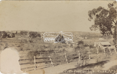
Postcard - Photograph, Eltham from Greensborough Road, No. 1, c.1910
The view is looking southeast from near Eltham Road (present-day Sherbourne Road) across Bolton and Bridge streets towards the village of Little Eltham running down the main road (Maria Street) . On the immediate right is Mrs Mary Jane Smart's family home located on the north side of Bridge Street at the intersection with Bolton Street, facing Bolton Street (now part of present day Brisbane Street and occupied by the Kitchen Design Centre). An original early settler's cottage, it was built by Mary Jane Smart's parents, Edwin Bailey and Jane (nee Matthews). Mary Jane Smart was born in the cottage. She married an Englishman, Alexander Wilson Smart who disappeared to Western Australia in the early 1900s in search of gold. He ultimately married again in W.A., committing bigamy and then committed murder and was hung in 1911. Visible at the top left are Watson's (two-storey) Eltham Hotel at the corner of Pitt Street and Maria Street and the Evelyn Hotel directly opposite.Sepia postcardNotations in biro 'A. Petrie', rest in pencil as follows St Margarets N end Shows Wesleyan Church Small Bank Double Storey on Hotel's south end Pearsons house Note roof structure Surface damage to lower left corner1910, bridge street, cba bank, church, clark bros. photo, early settlers, eltham, eltham hotel, evelyn hotel, fountain of friendship hotel, greensborough, mary jane smart (nee bailey), pearson house, pre 1900, road no 1, smart family home, smart home, st margarets, watsons hotel, wesleyan church -
 Orbost & District Historical Society
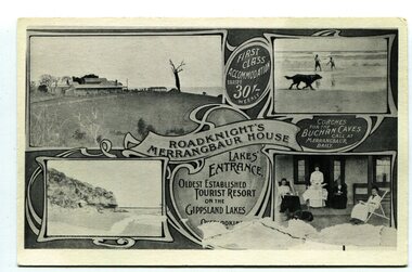
black and white postcard, C1910
This an advertisement / souvenir for Merrangbaur House in Lakes Entrance. Merrangbaur was in , Lakes Entrance and stood on the on the Prince's Highway, about a kilometre from Lakes Entrance. It was destroyed by fire on the early morning of December 15, 1935. The original residence of the Roadknight family, the first white settlers in the Lakes Entrance district, Merrangbaur House had been conducted as a guest house for many years. Much of the furniture was lost, although a portion of the building, consisting of the ballroom and several bedrooms, was saved Mrs. Anne McInnes, aged more than 80 years, the mother of the proprietress, Miss McInnes, was the only guest sleeping in the house when the fire began and had to be assisted from her blazing bedroom on the ground floor. She was carried through a window by members of the fire brigade and spent the remainder of the night at the house of a friend. Miss McInnes was in Melbourne on a business visit arranging for Christmas bookings, when she was informed of her loss. (info. from The Argus Melbourne Monday December 16 1935)This item is associated with tourism in East Gippsland in the early 20th century.A black / white photograph / postcard.There is a photograph of a Lakes Entrance scene in each corner with a banner for "ROADKNIGHT'S MERRANGBAUR HOUSE' in the middle.In a circle is "FIRST CLASS ACCOMMODATION TARIFF 30/- WEEKLY". It has a note that "Coaches for Buchan Caves call at Merrangbaur daily".merrangbaur-lakes-entrance roadknight-lakes-entrance postcard-lakes-entrance -
 Orbost & District Historical Society
black and white photographs, first half 20th century
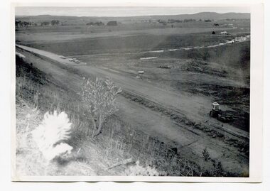
3255.1 is a photograph of the Princes Freeway construction of the roadway embankment at the foot of Newmerella Hill. 3255.2 is of the construction of the roadway, the Princes Freeway looking down from Newmerella toward Orbost. 3255.3 shows the Princes Freeway from Grandview , Newmerella, and shows the southern end of Ashby's Gulch with its bridge. 3255.4 is of the Princes Freeway showing the bridge across Ashby's Gulch and a train on the railway viaduct. Ashby's Gulch is named for the Ashby family. The Ashby family was one of the early settlers in Orbost at Newmerella. Roy Ashby, son of James Rowland Ashby and Edith Annie Hall, was born on 21 Nov 1892 in Orbost. Victoria. Australia and died in 1942 in Orbost. Victoria. Australia at age 50. Roy married Elsie May Stephens, daughter of James Stephens and Sarah Taylor, in 1920 in Victoria.Australia. Elsie was born on 15 Sep 1898 in Beaconsfield Tasmania.Australia and died in 1974 in Orbost Australia at age 76. Their children were: Roy Ashby, William Henry Ashby, Cordelia Valma Ashby and Edith Ashby. This photograph is associated with the construction of the main roads into Orbost. It is also connected to the Orbost to Bairnsdale Railway.Four black / white photographs of road construction and rail bridges.road-construction-newmerella princes-freeway-newmerella ashby's-gulch-newmerella orbost-railway -
 Orbost & District Historical Society
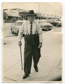
Photograph - Photograph off Albert Trewin
Albert (Abby) Trewin (b.21.03.1876 d. 01.07.1970) was part of the Trewin family who were early settlers at Jarrahmond near Orbost. Albert was born at Kingston near Ballarat, shifted to Jarrahmond where the house was called "Hillview", located 3 miles from Orbost on the B Road. The Trewin selection at Jarrahmond had many big trees on it and because these looked a bit like Jarrah trees from Western Australia, they names their property Jarrahmond (which became the district location and the name of Jarrahmond School). He cleared the land with bullocks, horses, crosscut saws, burned the stumps, burying some logs which were too big to burn. Then they milked cows, planted maize, had pigs, drove the pigs to Bairnsdale or to Waygara (c. 1915 when the train reached Waygara) on a buggy track through the bush. Pigs went to Dandenong Bacon Factory where they were processed into Dandy Ham. This photograph appears to be c.1950s - 1960s.A photograph of one of Jarrahmond's earliest settlers.B/W photograph of a man walking along a footpath. He is wearing a hat and has a walking stick in his right hand. He is wearing braces, white long-sleeved shirt, striped tie, glasses, polished black shoes. Behind him are vehicles and buildings (shops). jarrahmond, farming -
 City of Moorabbin Historical Society (Operating the Box Cottage Museum)
Photograph, Black & White Gulliver's House, Marian Lodge, Methodist Childrens Home Cheltemham, c1935
The Methodist Children's Home was originally the home of Mr Gulliver a chemist. It became the centre of a farm at the Home. When the Home was sold to the Catholic Church 1953 it was renamed 'Marian Lodge'. The Methodist Children's Home in Cheltenham was founded c1880 to provide housing for neglected children from the inner city. The Founders aimed to provide regular nourishment, a stable environment and integrate the children into the local community thereby improving their education and lives. However new settlers to Cheltenham area who were seeking a healthier and more respectable lifestyle for their families were not happy to share Church and School with the Home's Children. ( see 00561) 1950's saw a new direction for the support of children and families in poor and difficult situations . The new Methodist Burwood Homes Facility opened in 1951 and children were transferred from Cheltenham in 1952. The land was sold to the St John of God, Catholic Order in1953 who maintained an orphanage until Myer Pty Ltd bought the site in 1967 and constructed the Southland Shopping Centre c1892-1953 The Methodist Children's Home Cheltenham was founded to provide safe accommodation and education for neglected children from the inner city slums. The St John of God Order purchased the Home 1953 and the land was sold to Myer Pty Ltd. who built Southland Shopping Centre 1967 Black & White photograph showing a farm house that was originally owned by Mr Gulliver, a chemist and then the Methodist Children's Home was established 1892. Named Marian Lodge after the St John of God Catholic Order purchased the property in 1953 Back Hand written information st john of god home cheltenham 1953-1967, marian lodge, mr gulliver, pharmacy, methodist childrens home cheltenham 1892-1953, myer southland 1967, city of moorabbin, county of bourke, moorabbin roads board, parish of moorabbin, shire of moorabbin, henry dendy's special survey 1841, were j.b.; bent thomas, o'shannassy john, king richard, charman stephen, highett william, ormond francis, maynard dennis, cheltenham state school no.84, methodist chapel cheltenham, methodist school cheltenham, beaumaris west state school, meeres frederick, meeres walter, education, early settlers, -
 Wodonga & District Historical Society Inc
Negative - Haeusler Glass Negatives Collection - McKoy's horse, c1910
The Wodonga Historical Society Haeusler Collection provides invaluable insight into life in late nineteenth and early twentieth century north east Victoria. The collection comprises manuscripts, personal artefacts used by the Haeusler family on their farm in Wodonga, and a set of glass negatives which offer a unique visual snapshot of the domestic and social lives of the Haeusler family and local Wodonga community. The Haeusler family migrated from Prussia (Germany) to South Australia in the 1840s and 1850s, before purchasing 100 acres of Crown Land made available under the Victorian Lands Act 1862 (also known as ‘Duffy’s Land Act’) in 1866 in what is now Wodonga West. The Haeusler family were one of several German families to migrate from South Australia to Wodonga in the 1860s. This digital image was produced from one of the glass negatives that form part of the collection, probably taken by Louis Haeusler (b.1887) with the photographic equipment in the Wodonga Historical Society Haeusler Collection. The McKoy family were also early settlers of Wodonga.This item is unique and has well documented provenance and a known owner. It forms part of a significant and representative historical collection which reflects the local history of Wodonga. It contributes to our understanding of domestic and family life in early twentieth century Wodonga, as well as providing interpretative capacity for themes including local history and social history.Digital image created from the Haeusler Glass negative collection. An image of a man standing on the right of the image holding onto reins of a horse owned by the McKoy family of Wodonga. C. 1910wodonga pioneers, haeusler family, glass negatives, dry plate photography, mckoy family -
 Bendigo Historical Society Inc.
Document - MANUSCRIPT: THE ''HISTORY OF OLD INGLEWOOD'' (NO ACTUAL TITLE)
Thirty paged manuscript re the ''History of old Inglewood'' (No actual title or stated author. The 'Preface' (last page) states that in 1961 the town would celebrate its centenary and, also, that it lost its official identity (amalgamation with the Shire of Korong). Comprises:Introduction; Aboriginal life and early history of interaction with settlers; Major Mitchell exploration in area (''Yarrayne'' as name given for the Loddon; Mt Korong - aboriginal ''Barrabungale''); Pioneers on the Loddon - land tenure (Order of Council 1847), ref to Simson (Donald Campbell; Hector Norman); Charlotte Plains (run); John Catto (of Loddon) and John Catto (of Berlin); William Allen; Alexander Moffat Allen; Mr Sellars; 1852 gold rush to Mt Korong (surface); 1859 discovery of gold at Inglewood ( A J Thompson, T Thompson, T Harvey); detail of gold mining in Inglewood; Borough of Inglewood (1863); growth of the town - hotels, banks, newspapers; 1863 fire in township; fire brigade at Inglewood; selection of land; the ''Land Convention''; the ''Duffy Act''; land selection; 'modern' developments in Inglewood(rail, gas); Jack Donaldson - runner 100 yds sprint title; armed services involvement of Inglewood (WW1 & WW2); government departments.inglewood, history, early history, lodden, mt korong, donald campbell, hector norman, inglewood fire brigade, duffy act, jack donaldson, alexander moffat, john catto, major mitchell, ww1, ww2. aboriginal life, order of council 1947. -
 Eltham District Historical Society Inc
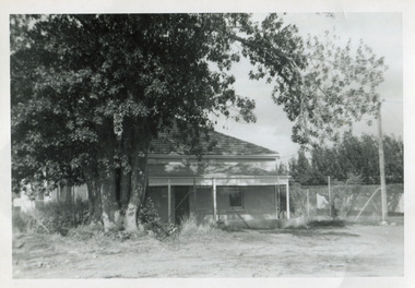
Photograph, Edendale Farm, Eltham Heritage Tour, 24 May 1992, 24/05/1992
ELTHAM HERITAGE TOUR The Society excursion on 24th May 1992 was arranged by David Bick, leader of the team carrying out the Shire's heritage study. David selected a number of sites or buildings identified in the study, some of them lesser known components of the Shire's heritage. The tour commenced at the Eltham Shire Office at 10.00 am. Travel was by private car and mini-bus with stops at about twelve locations for commentary by David.It included a short walk in Hurstbridge and lunch at Kinglake. Highlights of the tour included: - 10 am Leave from Shire Offices - 3 Important Trees - A Physical Link to Eltham's First Settlers - Toorak Mansion Gates - A Surviving Farm House - An Intact Circa 1900 Main Street - First Settlers - Gold Miners, and Timber-getters - An Early Hotel - A Pioneering Homestead - Changing Eltham Shire - 20th Century - 4 pm Afternoon Tea and Finish Tour Extract from ELTHAM CULTURAL HERITAGE TOUR (Newsletter No. 85, July 1992, by Bettina Woodburn) "The land was unprofitable for intensive farming, but there was always water in the Diamond Creek. The railway, a technological advance, followed the valley, and was provided to transport produce. At North Eltham we were privileged to tour a surviving farmhouse of the 1860-70 era at the Shire’s Edendale Farm, with the as yet unfinished Sculpture for a front fence - bulbous tree-trunks decorated with salt pots, with cross members from the old trestle bridge. As was usual these six veranda posted houses faced South (or East, away from the sun!) with the scullery, kitchen and pantry "out the back". The veranda, which must have been very narrow, no longer exists. It probably wrapped around three sides. The drive took us past the Dutch Windmill, only twenty years old and in the Shire of Diamond Valley, then the Diamond Creek Cemetery with impressive gateway, to a detour to see another old farmhouse, isolated on a hill off Murray Road Wattle Glen. Here was a particularly thick patch of exotic planting of pines and cypresses. Subsistence farming no longer pays. Following the rail-line we noticed on the left near Silvan Road an Edwardian cottage and on the right near Yates Road the old school residence for this Upper Diamond Creek area."Record of the Society's history and activities and highlighting various aspects of the Heritage Study undertaken by David Bick used to create the future heritage overlay for the Shire of Eltham and later Nillumbik Shire.Roll of 35mm colour negative film, 4 stripsKodak Gold 100 5095eltham, shire of eltham historical society, activities, heritage tour -
 Eltham District Historical Society Inc
Photograph, Edendale Farm, Eltham Heritage Tour, 24 May 1992, 24/05/1992
ELTHAM HERITAGE TOUR The Society excursion on 24th May 1992 was arranged by David Bick, leader of the team carrying out the Shire's heritage study. David selected a number of sites or buildings identified in the study, some of them lesser known components of the Shire's heritage. The tour commenced at the Eltham Shire Office at 10.00 am. Travel was by private car and mini-bus with stops at about twelve locations for commentary by David. It included a short walk in Hurstbridge and lunch at Kinglake. Highlights of the tour included: - 10 am Leave from Shire Offices - 3 Important Trees - A Physical Link to Eltham's First Settlers - Toorak Mansion Gates - A Surviving Farm House - An Intact Circa 1900 Main Street - First Settlers - Gold Miners, and Timber-getters - An Early Hotel - A Pioneering Homestead - Changing Eltham Shire - 20th Century - 4 pm Afternoon Tea and Finish Tour. Extract from ELTHAM CULTURAL HERITAGE TOUR (Newsletter No. 85, July 1992, by Bettina Woodburn) "The land was unprofitable for intensive farming, but there was always water in the Diamond Creek. The railway, a technological advance, followed the valley, and was provided to transport produce. At North Eltham we were privileged to tour a surviving farmhouse of the 1860-70 era at the Shire’s Edendale Farm, with the as yet unfinished Sculpture for a front fence - bulbous tree-trunks decorated with salt pots, with cross members from the old trestle bridge. As was usual these six veranda posted houses faced South (or East, away from the sun!) with the scullery, kitchen and pantry "out the back". The veranda, which must have been very narrow, no longer exists. It probably wrapped around three sides. The drive took us past the Dutch Windmill, only twenty years old and in the Shire of Diamond Valley, then the Diamond Creek Cemetery with impressive gateway, to a detour to see another old farmhouse, isolated on a hill off Murray Road Wattle Glen. Here was a particularly thick patch of exotic planting of pines and cypresses. Subsistence farming no longer pays. Following the rail-line we noticed on the left near Silvan Road an Edwardian cottage and on the right near Yates Road the old school residence for this Upper Diamond Creek area."Colour photograph1992, culture, edendale, edendale community farm, events -
 Orbost & District Historical Society
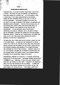
black and white photograph, Warren, Mrs H, 1934
This is a photograph of the twin daughters of Mrs Trixie Mason - Marion and May,. They had a brother Alec Mason. The Mason Twins are the granddaughters of George and Agnes Thomas from Newmerella . The photographer was Warren, Helena (1871-1962) who was a self-taught photographer who became both the local press correspondent and a producer of humorous trompe l'oeil postcard images. Helena Warren was a thirty-two year old settler living on a small mixed farm with her husband, William, at Newmerella, near Orbost in Gippsland, Victoria, when she bought her first camera, an Austral Box quarter-plate. Her family says she was entirely self-taught, like many women photographers who started out with nothing but the instructions on the packets of film and chemicals. In over fifty years practice she graduated from the total novice, who opened all her first mail order plates in bright sunlight and ruined them, to a competent photographer who became both the local press correspondent and an inveterate producer of humorous trompe l’oeil postcard images.This photograph has significance in its association with Helen Frances Warren, a popular Orbost identity who was well known as an accomplished photographer and needleworker.A black / white photograph of two small twin Aboriginal girls in a large pumpkin floating on water. There is a Union Jack at each end with "HMAS CENTENARY 1934" on the side.pumpkins-orbost warren-helena-photographer mason-marion mason-may aboriginal-children -
 Eltham District Historical Society Inc
Photograph - Digital Photograph, Alan King, Memorial Arch Gateway, Nillumbik Cemetery, Diamond Creek, 23 January 2008
The Nillumbik Cemetery is of historical, architectural, aesthetic and social significance at a Regional level (North-east Melbourne). The memorial arch is of State significance. Nillumbik Cemetery, which was established in 1867, is of historical and social significance for its association with the early history of Diamond Creek and as a record of the pioneering families of the district. Significant graves include those of the famous writer Alan Marshall, author of 'I Can Jump Puddles', footballer Gordon Coventry, and William Ellis, notable early settler and benefactor. The 1897 Tudor/Gothic revival memorial arch, bequeathed by William Ellis, is a rare design in ornamental gateways and is relatively large for the size of the cemetery. It is unique in Victoria as a cemetery gateway arch. The burial ground has associated structures, such as the hexagonal timber sexton's office, post and wire fence and picket hand gate along Main Street, all probably built in the early twentieth century. Covered under Heritage Overlay, Nillumbik Planning Scheme. National Trust of Australia (Victoria) - Regional significance Published: Nillumbik Now and Then / Marguerite Marshall 2008; photographs Alan King with Marguerite Marshall.; p83This collection of almost 130 photos about places and people within the Shire of Nillumbik, an urban and rural municipality in Melbourne's north, contributes to an understanding of the history of the Shire. Published in 2008 immediately prior to the Black Saturday bushfires of February 7, 2009, it documents sites that were impacted, and in some cases destroyed by the fires. It includes photographs taken especially for the publication, creating a unique time capsule representing the Shire in the early 21st century. It remains the most recent comprehenesive publication devoted to the Shire's history connecting local residents to the past. nillumbik now and then (marshall-king) collection, diamond creek, memorial arch, gateway, nillumbik cemetery, william ellis -
Glenelg Shire Council Cultural Collection
Souvenir - Tea Towel - Maretimo, Portland, n.d
From the National Trust register: Statement of Significance Maretimo, a 22 room single storey Australian Colonial Georgian style mansion set on a prominent bluff overlooking Portland harbour, was erected c. 1854 for John Norman McLeod. The design of Maretimo, which is constructed of basalt ashlar with fine-axed parapet entablature, delicate open timber work verandah and Regency interior, has been tenuously attributed to Adelaide architect James Barrow. Maretimo is rivalled only by the stylistically similar Henty residence, Burwsood of 1853 by James Barrow, as perhaps the finest Australian Colonial Georgian style residence erected within the first twenty years of settlement in Victoria. The residence, which was occupied for twenty years by distinguished English-born gentleman parliamentarian, pastoralist and former Van Deimen's Land settler, J H McLeod, is now notable for the disciplined facade and elegantly crafted interiors. Maretimo has been meticulously maintained and is presented in near perfect original condition. The interiors have been sensitively enhanced and redecorated.Linen souvenir tea towel 'Maretimo'. Green and black on cream. 'MARETIMO' at top, front view of Maretimo beneath, then map of locaion, then view from air. 'HISTORIC HOME PORTLAND, VICTORIA' beneath 'Pure Linen', bottom right.historic building, historic homestead, maretimo, henty, souvenir -
 Eltham District Historical Society Inc
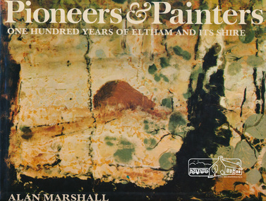
Book, Alan Marshall (1902-1984), Pioneers & painters : one hundred years of Eltham and its shire, 1971
Jacket painting by Clifton Pugh. "Eltham Shire is a well known as a district in which a large number of painters, sculptors, potters, writers and other creative people, The early settlers were, for the most part, resourceful and far-sighted ; the present residents are no less so. Mention the name Eltham and many things spring to mind ; conservation ; the integration of architecture with the environment ; mud-brick buildings; Montsalvat - the list is endless. In 1971, the centenary of the Shire's birth, the Council felt that the publication of a history would fittingly mark more than a century of achievement.." - Dust jacket. Contents: The Beginning Kangaroo Ground Education at Kangaroo Ground The Days of Gold Queenstown Panton Hill The Pioneer Women Christmas Hills and Yarra Glen Eltham Education at Eltham and Research Kinglake Hurstbridge by Sheila Ferguson Montmorency and Lower Plenty The New Way of Life Old Identities Eltham in modern times Educationalists and Writers Earth building in Eltham Early Painters by Peter Glass Painters Today by Peter Glass Warrandyte painters and Potters by Peter Glass Wildlife Present day This book provides a comprehensive history of the former Shire of Eltham and its first one hundred years. Hardback Book with Dust Jacket - 144 p. : illus. (part col.) ; ISBN 0170019489 eltham, alan marshall, shire of eltham, clifton pugh -
 Orbost & District Historical Society
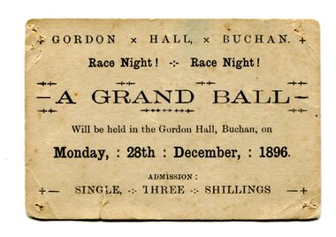
Document - ticket, 1896
Gordon Hall was the first public building in Buchan. European settlement first entered the area in October 1838 and Buchan station was established in January 1839. Free selection after 1868, and a township was proclaimed in 1873 taking its name from the station. The Grand ball was held on race night, Monday 28th December 1896 in the Gordon Hall at Buchan. From the estate of Elsie Cooke. Elsie Cooke was a librarian in Orbost for many years. She was the daughter of John Cooke early Brodribb settler. Elsie Cooke lived all her life in Gippsland,. She was born at Brodribb in 1895 and died in 1970, Elsie Cooke lived at Bruthen for a short time and, in 1937, moved to live with her aunt, Miss Jean Munro. Miss Cooke was Librarian at the Mechanics Institute for many years. Kindness and consideration for other were Miss Cooke’s attributes and she endeared herself to all who knew her. She was a loyal member of the Presbyterian Church and a stalwart of the Ladies’ Guild, an energetic worker for the Municipal Auxiliary and a member of the Red Cross. (ref. Mary Gilbert)This item reflects the recreational / social activities of a remote rural community. A public event such as a grand ball would have been a significant event on the calendar.Small, cream-coloured rectangular card with rounded edges and blank ink. Evidence of pin holes in each four corners and folds/signs of wear. Card is foxing and has small vertical tear in lower left quadrant.+ GORDON x HALL, x BUCHAN. + / Race Night! - Race Night! / A GRAND BALL / Will be held in the Gordon Hall, Buchan, on / Monday, : 28th : December, : 1896. / ADMISSION : / +- SINGLE, THREE SHILLINGS -+grand ball, 1896, gordon hall, buchan, elsie cooke -
 Orbost & District Historical Society
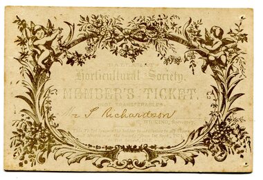
membership ticket, September 1 1874
The Richardson family was one of the very early settler families to establish themselves in the Orbost district. Samuel Richardson was a sawmiller and farmer in Orbost. He built The Curlip, a wooden paddle-steamer of 9 tons gross and dimensions of 43 feet long, 10 feet wide and a depth of 3 feet, on the slipway at their Tabarra sawmill in 1890. The Ballarat Horticultural Society was established in 1859 by a group of thirteen men with the aim of establishing an association for all lovers of horticulture. There were many such societies throughout the colonies making a contribution to their communities. In May 1852 Richard Wicking and his younger brother Frederick followed their father’s footsteps, leaving England to pursue a new life in the distant colony of Port Phillip. Sailing on the maiden voyage of the 'Roxburgh Castle' a new purpose built ship for the long voyages from London to Australia. Arriving on August 28th 1852, having paid their own fares they were "Unassisted Passengers". The brothers spent two years in Melbourne. He spent some tome in Ballarat and became a prominent community member involved in many areas.The Richardson family was one of the very early settler families to establish themselves in the Orbost district. Samuel Richardson was builder of the Paddle Steamer Curlip. This is a useful research tool. An ornately designed card with an oval frame of flowers and cherubs. It is a Ballarat Agricultural Society membership ticket made out to Mr S. Richardson (hand written) and endorsed by R. Wicking , the secretary.on back - hand-written - "J E Richardson"ballarat-horticultural-society richardson-samuel -
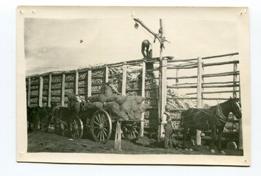
 Orbost & District Historical Society
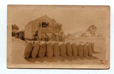
Photograph, 1930s
Maize has been grown on the Orbost flats for at least 70 years. When early settlers began to arrive on the Snowy River somewhere in the 1880s, the land was mostly swamps and heavily timbered jungle on the river frontages. The swamps were drained, bit by bit, with short handled shovels working in mud and water. The frontages were cleared by axe and shovel and fire. Several kinds of crops were experimented with such as hops, hemp and maize which grew particularly well and became the main crop of district. The problem then was to thresh and deliver the product to the market. A small single cob machine was brought here and one man turned the handle, while the boy or Mum fed the cobs singly into the machine. A good day’s work would thresh about 50 bushels or about 12 bags (4 bushels). The task then was to cart the maize to market. For a few years this was done by horses and dray carrying about 60 bushels to Mossiface, where it was loaded onto river boats to Lakes Entrance, and then by ocean boats to Melbourne. (information from NEWSLETTER OCTOBER, 2006)The growing of maize in the Orbost district contributed significantly to the economy of the township for many years, The many maize cribs once seen on the surrounding farms have now disappeared and this photograph is a pictorial record of that significance.A small sepia photograph with six men in front of a wooden barn. They are bagging maize. In the foreground are two rows of filled bags. On the right is a lifting machine to take the bags to the top storey. On the far right is a water tank on a stand"on back - "Thrashing Maize"maize-orbost agriculture-maize industry -
 Wodonga & District Historical Society Inc
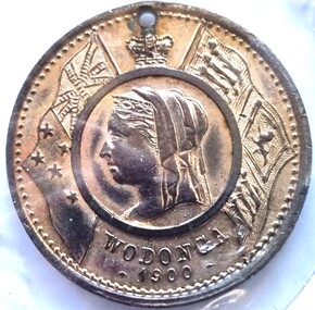
Memorabilia - Boer War Peace Medallion
In 1899 the Boers, descendants of Dutch settlers, declared war on the British forces. Enthusiastic civilians throughout the Australian colonies volunteered for service, supported by their respective colonial governments. After Federation Commonwealth units were also mobilised. Others who were unable to join Colonial or Commonwealth units enlisted in forces raised by other nations including Britain and South Africa. The first joint colonial regiment, the Australian Regiment, was formed from companies representing Victoria, South Australia, Western Australia and Tasmania. The British gradually wore down Boer resistance, and peace was declared on 31 May 1902. Over 15,000 Australians served in the Boer War. Australian casualties totalled about 1400, with 518 killed. Six Australians were awarded the Victoria Cross for their bravery. Children in schools around the different colonies of Australia (this was prior to Federation) raised money to hold Peace picnics. Wodonga's Peace picnic was held at the racecourse. Only about 70 of these medallions were struck. They were presented to the children who raised the most money for the Peace picnic in each area.This artefact has local, national and international significance as it recognises the first major international conflict in which Australian colonial soldiers were involved,A small medallion issued in commemoration of peace at the end of the Boer War. There is a hole through the top so that it can be attached to a chain or clip.OBVERSE SIDE: At centre within line circle veiled head of Queen Victoria facing left, at top of circle, crown, at sides Australian and Royal flags; below, WODONGA 1900 REVERSE SIDE: Within wreath, IN / COMMEMORATION / OF / PEACE / BRITISH BOER / WAR / "LEST WE FORGET"australian commemorative medals, boer war 1899 - 1902, boer war peace medallion -
 Orbost & District Historical Society
black and white photograph
Maize,has been grown on the Orbost flats for at least 70 years. When early settlers began to arrive on the Snowy River somewhere in the 1880s, the land was mostly swamps and heavily timbered jungle on the river frontages. The swamps were drained, bit by bit, by men with short handled shovels and working in mud and water. The frontages were cleared by axe and shovel and fire. Several kinds of crops were experimented with such as hops, hemp and maize, the latter grew particularly well and became the main crop of district. The problem then was to thresh and deliver the product to the market. A small single cob machine was brought here and one man turned the handle, while the boy or Mum fed the cobs singly into the machine. A good day’s work would thresh about 50 bushels or about 12 bags (4 bushels). The task then was to cart the maize to market. For a few years this was done by horses and dray carrying about 60 bushels to Mossiface, where it was loaded onto river boats to Lakes Entrance, and then by ocean boats to Melbourne. Later it was taken to Bairnsdale by foot and loaded onto the trains to Melbourne. (more information in Newsletter October 2006)The growing of maize in the Orbost district contributed significantly to the economy of the township for many years, The many maize cribs once seen on the surrounding farms have now disappeared and this photograph is a pictorial record of that significance.A black / white photograph of a man unloading maize from a horse-drawn wagon into a maize crib. Another man is standing by the horse.maize-crib-orbost agriculture maize-corn-orbost -
 Orbost & District Historical Society
black and white photograph, Warren. Mrs H, first half 20th century
Many farmers on the flats at Orbost used to grow a lot of maize and harvest the maize by putting the pigs in to eat the maize.. Maize and pumpkins fed in conjunction were largely used for fattening pigs. The photographer was Warren, Helena (1871-1962) who was a self-taught photographer who became both the local press correspondent and a producer of humorous trompe l'oeil postcard images. Helena Warren was a thirty-two year old settler living on a small mixed farm with her husband, William, at Newmerella, near Orbost in Gippsland, Victoria, when she bought her first camera, an Austral Box quarter-plate. Her family says she was entirely self-taught, like many women photographers who started out with nothing but the instructions on the packets of film and chemicals. In over fifty years practice she graduated from the total novice, who opened all her first mail order plates in bright sunlight and ruined them, to a competent photographer who became both the local press correspondent and an inveterate producer of humorous trompe l’oeil postcard images.This item is a pictorial record of farming in Orbost in the early 20th century. It is also associated with Helena Warren. a well-known photographer born in Orbost.a black / white photographagriculture farming-orbost pumpkins maize pigs warren-helena -
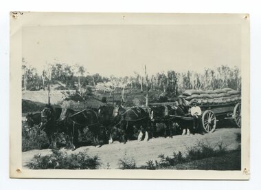 Orbost & District Historical Society
black and white photograph, late 19th century - early 20th century
Maize, or corn as it is called in America and New South Wales, has been grown on the Orbost flats for at least 70 years. When early settlers began to arrive on the Snowy River somewhere in the 1880s, the land was mostly swamps and heavily timbered jungle on the river frontages. The swamps were drained, bit by bit, by stout hearted men with short handled shovels and working in mud and water. The frontages were cleared by axe and shovel and fire. Several kinds of crops were experimented with such as hops, hemp and maize, the latter grew particularly well and became the main crop of district. The problem then was to thresh and deliver the product to the market. A small single cob machine was brought here and one man turned the handle, while the boy or Mum fed the cobs singly into the machine. A good day’s work would thresh about 50 bushels or about 12 bags (4 bushels). The task then was to cart the maize to market. For a few years this was done by horses and dray carrying about 60 bushels to Mossiface, where it was loaded onto river boats to Lakes Entrance, and then by ocean boats to Melbourne. ( from NEWSLETTER OCTOBER, 2006) This is a pictorial record of farming practices in Orbost in the early 20th century.A black / white photograph of a horse team hauling a wagon loaded with bags of maize.A man is sitting on the edge of the wagon.farming-orbost agriculture maize corn transport -
 Warrnambool and District Historical Society Inc.
Article, Henry Pulteney Dana and his Native Police, 1970s
This item is a copy of an article on Henry Dana and the Native Police of the 1840s and 50s in Victoria. Henry Dana’s police corps is regarded as the forerunner of today’s Victorian Police Force. The article was written by Stan Baulch when he was a member of the Warrnambool and District Historical Society, probably in the 1970s. The paternal grandparents of Stanley Samuel Baulch (1897-1980) were Francis and Ann Baulch, pioneer settlers in the Kirkstall area in the 1840s. Stan’s father, Samuel Baulch, established a property in the Macarthur/Hawkesdale area in the 1870s (Rose Park) and in 1893 bought the nearby property of Dunmore which had been established in the 1840s by Charles Hamilton MacKnight and partners. (It was when Stan Baulch was reading the 19th century diary of Charles MacKnight that he first came across the story of Henry Dana and the native police). Stan Baulch inherited part of the Dunmore estate on his father’s death and this he named Rose Park, using his father’s property’s name. Stan Baulch had a great interest in local history and as well as the article on Henry Dana he also produced a booklet on early bullocking and bullock-drivers in the Western District. This article is a copy so does not have any strong historical significance but another copy of it will be a useful file item in the collection of the Warrnambool and District Historical Society.This is an article of 8 foolscap pages, with the material in it being a typed copy. The first page has two photocopied illustrations. stanley baulch, rose park, western district,, victoria, history of warrnambool -
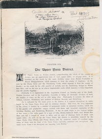 Eltham District Historical Society Inc
Folder, The Upper Yarra District, 1888
Photocopies from "Victoria and its Metropolis: Past and Present". Chapter 19, "The Upper Yarra District" pages [402] - 415. Includes descriptions of some townships and short biographies of local residents. Victoria and Its Metropolis' is a large two volume history of Victoria, written in 1888 by Alexander Sutherland. It contains a huge amount of information on the people of the colony and its early history. The first volume covers information from the discovery of Australia, through to the exploration of Victoria and the first settlers to the pioneers. It then continues on to discuss immigration, the era of gold, the development of government, agriculture, music and art, literature and the metropolis of Melbourne. A large portion of the second volume examines the colony by district, which covers many districts throughout the state as well as the metropolitan area. Hundreds of biographical entries are scattered throughout and a comprehensive biographical index is included at the end. The British Library has scanned Volume 2 and it can be downloaded at http://access.bl.uk/item/pdf/lsidyv30336ba8 Images from the book are on Flickr Commons via the British Library https://www.flickr.com/photos/britishlibrary/ Keywords in this record highlight those residents connected to Eltham and district7 A3 Pages HG Booklet 45harry gilham collection, james andrew, w. b. andrew, alfred armstrong, simon armstrong, thomas armstrong, john bell, mary ann bell, thomas m bell, ewen hugh cameron, mary cameron, james charlton, j.m conolly, andrew harkness, william hubbard, james johnston, james mcpherson, robert parry, george stebbing, joseph stevenson, j.b. thomas, james thomson, mary weller, isidore t. wilmot, john b. wilson, walter wippell -
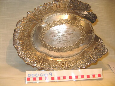 Warrnambool and District Historical Society Inc.
Domestic object - Serving dish, Late 19th century
This plate was presented in 1900 to a Warrnambool lawyer, William Ardlie, on the occasion of his marriage to Maud Taylor. It was recovered from the fire which destroyed the Hotel Mansions building in Warrnambool in 1929. This building was opened in 1890 as the Grand Ozone Coffee Palace (a temperance hotel). It was at the corner of Koroit and Kepler Streets. In 1891 the Coffee Palace was granted a wine licence and in 1895 it was re-named the Ozone Hotel. The building was closed in 1915 and re-opened in 1920 as the Hotel Mansions. In 1923 the Hotel Mansions became a fully-licensed hotel and in 1929 it was destroyed by fire. The present-day Hotel Warrnambool was built on the site. William Ardlie, the son of a pioneer Warrnambool settler, John Ardlie, began practising as a lawyer in Warrnambool in the mid 1860s and dominated the legal scene in Warrnambool, continuing on his practice until he was over 80. He and his second wife, Maud, were occupying an apartment in the Hotel Mansions when it was destroyed by fire and this plate is a relic of the fire. The Warrnambool Bowling Club which presented the plate to William Ardlie, was established early in the 1890s and William Ardlie was an enthusiastic supporter and one-time office bearer.This plate is of great significance as it was one of the few items that still exist that was recovered from the 1929 Hotel Mansions fire and its story contains so much of Warrnambool’s history with its connections to:- 1. The story of the Hotel Mansions, the grandest building ever erected in Warrnambool 2. The story of William Ardlie, a dominant figure in the legal world in Warrnambool for over 60 years 3. The story of the Warrnambool Bowls Club, still existing today. This is a silver plate with an oval base with an inside ring and a rim of scroll patterning. The recessed edges of the plate are highly ornamented with scrolls and flower patterning. Parts of the edge of the plate are missing and jagged as this plate has been in a major fire. On the base of the plate are three silver studs for the plate to rest on a surface. The fourth stud is missing. On the rim of the plate are two small projections, suggesting the plate originally had a handle. On the base of the plate is an inscription.‘Presented by the members of the Warrnambool Bowling Club to William Ardlie Esq.re (ex President) on the occasion of his WEDDING, 10th January 1900.’ grand ozone coffee palace/ozone hotel/ hotel mansions, warrnambool, william ardlie, warrnambool bowls club, history of warrnambool -
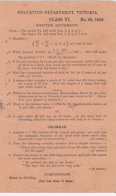 Cheese World Museum
Document, School test -arithemetic Grade VI
The Uebergang family came from Silesia to Australia in 1848 and were early settlers in the Allansford area. The sons and other descendants also purchased farms in the area. The Percy Uebergang family lived at Tooram Park, Allansford from 1912 until 1992. Percy and Myrtle Uebergang's children were twins, Ray and Joyce born in 1926 who lived at Tooram Park until their deaths, Ray in 1986 and Joyce in 1992 after which the property was sold. Neither Ray nor Joyce married and following the death of her brother Joyce set up the Ray and Joyce Uebergang Foundation which supports the local community. The collection of items from their property was put into store for a number of years before being given into the care of the Cheese World Museum. The family often re-used, recycled and repaired items and examples can be seen in the museum. This item is part of the collection of items given into the care of the Cheese World Museum. The Victorian Education Department compiled set tests for schools. This test aimed at Year 6 students dates from 1904 and includes some complex written arithmetic problems, grammar analysis and an essay on 'Clothing'. This test sheet is significant as an example of the level expected of Class VI students in 1904.A single page printed in black ink on dull orange coloured paper with tests arithmetic, grammar and composition for Class VI, No.65, 1904 composed by the Education Department, Victoria.EDUCATION DEPARTMENT, VICTORIA/CLASS VI/No.65, 1904/WRITTEN ARITHMETIC/ … /GRAMMAR/…/COMPOSITIONallansford, grammar, school tests, arithmetic, composition, education department victoria, education, schools -
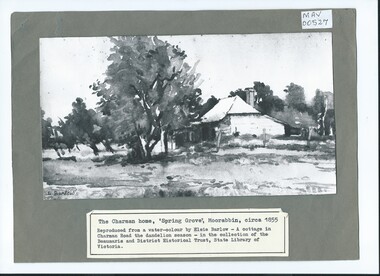 City of Moorabbin Historical Society (Operating the Box Cottage Museum)
Photograph, B/W Watercolour,'Spring Grove' Charman Cottage built c1855 E Barlow c 1900, Elsie Barlow, c1900
This is a B/W photograph of a Water colour by Elsie Barlow c 1900. The original water-colour is in the collection of the Beaumaris and District Historical Trust in the State Library of Victoria. 'Spring Grove' was the home of the Charman family in the Parish of Moorabbin. Stephen Charman, aged 21years, arrived in Melbourne in 1842 as one of Henry Dendy's Emigrants. 1852 he purchased 160 acres for £328 bounded by Charman Rd and Balcome Rd. 'The Spring' was an important water source for the local Aboriginal people and then for the early settlers. Charman's first wife Harriet and their infant child died and in 1850 he married a widow with 5 children, Mary Gettens. Their first home was made of wattle and daub and they had 7 more children. Later a weatherboard cottage was built c 1855 Together they developed a market garden and specialized in marigolds which were sold for medicinal purposes to the Melbourne Chemists - Martin & Pleasance . The first Methodist Church Services were held at Spring Grove and the Charmans donated land in 1857 for the first Chapel, Cemetery and Primary School . Mary died 1870 and Stephen married again and moved to Gippsland where he died aged 85 in 1906Stephen and Mary Charman were pioneer market gardeners in Moorabbin Shire 1842 and were involved in the development of Church, school and community in the area now called Cheltenham. Charman Road Cheltenham was a boundary of their land. Black & White photograph of a Watercolour of Charman family cottage built 1885 Cheltenham Signed E Barlow on back ; A Cottage in Charman Road - the Dandelion Season / by Elsie Barlow / In the Collection of the State Library Victoria / Reproduction requires the permission of the Library Moorabbin Standard Newspaper moorabbin, cheltenham, dendy henry, dendy's special survey 1841, assisted emigrants early settlers, pioneers, market gardeners, marigold flowers, pharmacy, charman stephen, gettens mary, charman harriet, methodist church, primitive methodists, box william, box elizabeth, state schools, education, moorabbin shire, moorabbin roads board, city of moorabbin, kingston city council