Showing 2104 items
matching structures
-
 Falls Creek Historical Society
Document - Indenture Between State Electricity Commission & Herman Hymans, 28.11.1956
Bob Hymans Collection Bob (Herman) Hymans (a former member of the Royal Netherlands Navy was born in Bloemendaal, Holland on 30th September 1922. During World War II he fought against the Japanese in the Dutch East Indies (now Indonesia) and was imprisoned in Changi and on the Burma Railway. After gaining qualifications as a Ski Instructor, Bob arrived in Falls Creek in May 1950. Working as an Instructor and Supervisor at Bogong Lodge, Bob decided his future was in accommodation. He was successful in negotiating an indenture for land from the State Electricity Commission (SEC). It took Bob two years to build his Grande Coeur Chalet but, tragically, it was burned down in August 1961. Bob also built the first Chairlift in Australia. This was a single chairlift and the structure was built from wooden electricity poles. He was constantly full of new ideas and proposals for the village. Bob Hymans died on 7th July 2007. This Collection of documents and letters tells the story of Bob’s endeavours to develop Falls Creek into the ski village it is today.This document is significant because it documents the story of an important pioneer of Falls Creek.A 5 page indenture or contract typed on paper. This document sets out the terms and conditions set down for the lease of land in Falls Creek at the cost of £1 per week.legal contract, bob hymans -
 Falls Creek Historical Society
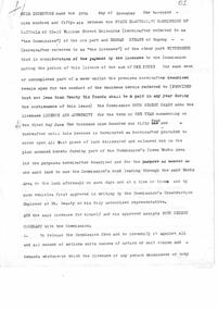
Letter - S.E.C. Preparing New Licences Of Sites, 18.12.1959
Bob Hymans Collection Bob (Herman) Hymans (a former member of the Royal Netherlands Navy was born in Bloemendaal, Holland on 30th September 1922. During World War II he fought against the Japanese in the Dutch East Indies (now Indonesia) and was imprisoned in Changi and on the Burma Railway. After gaining qualifications as a Ski Instructor, Bob arrived in Falls Creek in May 1950. Working as an Instructor and Supervisor at Bogong Lodge, Bob decided his future was in accommodation. He was successful in negotiating an indenture for land from the State Electricity Commission (SEC). It took Bob two years to build his Grande Coeur Chalet but, tragically, it was burned down in August 1961. Bob also built the first Chairlift in Australia. This was a single chairlift and the structure was built from wooden electricity poles. He was constantly full of new ideas and proposals for the village. Bob Hymans died on 7th July 2007. This Collection of documents and letters tells the story of Bob’s endeavours to develop Falls Creek into the ski village it is today.This document is significant because it documents the Rules of Falls Creek Tourist Area Regulations 1959.A letter from the Falls Creek Tourist Area Management Committee discussing the renewal of licenses at Falls Creek in December 1929. In respect of the four sites occupied by Bob Hymans, Grand Coeur Chalet, a transport terminal, the chairlift and a workshop, the licence fee in respect of each sites was to be set at £26 per annum.chairlift falls creek, bob hymans, grand coeur chalet, sec licenses -
 Falls Creek Historical Society
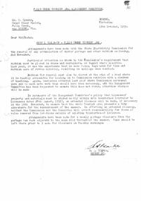
Letter - Requesting Permission To Construct New Access Road, 18.12.1959
Bob Hymans Collection Bob (Herman) Hymans (a former member of the Royal Netherlands Navy was born in Bloemendaal, Holland on 30th September 1922. During World War II he fought against the Japanese in the Dutch East Indies (now Indonesia) and was imprisoned in Changi and on the Burma Railway. After gaining qualifications as a Ski Instructor, Bob arrived in Falls Creek in May 1950. Working as an Instructor and Supervisor at Bogong Lodge, Bob decided his future was in accommodation. He was successful in negotiating an indenture for land from the State Electricity Commission (SEC). It took Bob two years to build his Grande Coeur Chalet but, tragically, it was burned down in August 1961. Bob also built the first Chairlift in Australia. This was a single chairlift and the structure was built from wooden electricity poles. He was constantly full of new ideas and proposals for the village. Bob Hymans died on 7th July 2007. This Collection of documents and letters tells the story of Bob’s endeavours to develop Falls Creek into the ski village it is today.This document is significant because it documents the Rules of Falls Creek Tourist Area Regulations 1959.A letter from the Falls Creek Tourist Area Management Committee referring to his request to build a new access road to his Grand Coeur Chalet. It states that the request must be considered in context of the overall plans of the Falls Creek Tourist Area but progress is being made.bob hymans, falls creek tourist area management committee -
 Falls Creek Historical Society
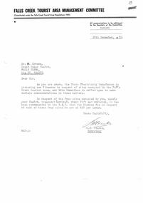
Letter - Annual Clean-Up Falls Creek Tourist Area, 16.10.1959
Bob Hymans Collection Bob (Herman) Hymans (a former member of the Royal Netherlands Navy was born in Bloemendaal, Holland on 30th September 1922. During World War II he fought against the Japanese in the Dutch East Indies (now Indonesia) and was imprisoned in Changi and on the Burma Railway. After gaining qualifications as a Ski Instructor, Bob arrived in Falls Creek in May 1950. Working as an Instructor and Supervisor at Bogong Lodge, Bob decided his future was in accommodation. He was successful in negotiating an indenture for land from the State Electricity Commission (SEC). It took Bob two years to build his Grande Coeur Chalet but, tragically, it was burned down in August 1961. Bob also built the first Chairlift in Australia. This was a single chairlift and the structure was built from wooden electricity poles. He was constantly full of new ideas and proposals for the village. Bob Hymans died on 7th July 2007. This Collection of documents and letters tells the story of Bob’s endeavours to develop Falls Creek into the ski village it is today.This document is significant because it documents the Rules of Falls Creek Tourist Area Regulations 1959.A letter from the Falls Creek Tourist Area Management Committee detailing arrangements made with the State Electricity Commission for the clean up of the Falls Creek area prior to the summer season. This was to ensure the removal of garbage and other rubbish which had accumulated during the winter.bob hymans, state electricity commission, sec falls creek -
 Falls Creek Historical Society
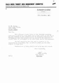
Letter - Re Letter To Tourist Development Authority, 15.10.1959
Bob Hymans Collection Bob (Herman) Hymans (a former member of the Royal Netherlands Navy was born in Bloemendaal, Holland on 30th September 1922. During World War II he fought against the Japanese in the Dutch East Indies (now Indonesia) and was imprisoned in Changi and on the Burma Railway. After gaining qualifications as a Ski Instructor, Bob arrived in Falls Creek in May 1950. Working as an Instructor and Supervisor at Bogong Lodge, Bob decided his future was in accommodation. He was successful in negotiating an indenture for land from the State Electricity Commission (SEC). It took Bob two years to build his Grande Coeur Chalet but, tragically, it was burned down in August 1961. Bob also built the first Chairlift in Australia. This was a single chairlift and the structure was built from wooden electricity poles. He was constantly full of new ideas and proposals for the village. Bob Hymans died on 7th July 2007. This Collection of documents and letters tells the story of Bob’s endeavours to develop Falls Creek into the ski village it is today.This document is significant because it documents the Rules of Falls Creek Tourist Area Regulations 1959.A letter from the Falls Creek Tourist Area Management Committee in response to Bob Hymans having written directly to the Tourist Development Authority. This was viewed as Bob Hymans not following correct communication protocols.bob hymans, falls creek tourist development authority protocols -
 Falls Creek Historical Society
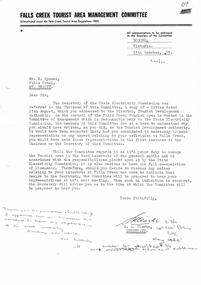
Letter - Meeting With Management Committee 24th Instant, 02.11.1959
Bob Hymans Collection Bob (Herman) Hymans (a former member of the Royal Netherlands Navy was born in Bloemendaal, Holland on 30th September 1922. During World War II he fought against the Japanese in the Dutch East Indies (now Indonesia) and was imprisoned in Changi and on the Burma Railway. After gaining qualifications as a Ski Instructor, Bob arrived in Falls Creek in May 1950. Working as an Instructor and Supervisor at Bogong Lodge, Bob decided his future was in accommodation. He was successful in negotiating an indenture for land from the State Electricity Commission (SEC). It took Bob two years to build his Grande Coeur Chalet but, tragically, it was burned down in August 1961. Bob also built the first Chairlift in Australia. This was a single chairlift and the structure was built from wooden electricity poles. He was constantly full of new ideas and proposals for the village. Bob Hymans died on 7th July 2007. This Collection of documents and letters tells the story of Bob’s endeavours to develop Falls Creek into the ski village it is today.This document is significant because it documents the Rules of Falls Creek Tourist Area Regulations 1959.A letter from the Falls Creek Tourist Area Management Committee notifying Bob Hymans of the date and location of a meeting at which his proposal for changes at Falls creek can be discussed.bob hymans, falls creek tourist area management committee -
 Falls Creek Historical Society
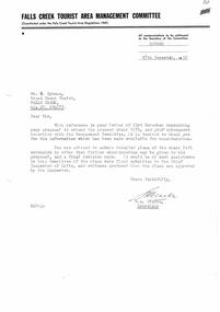
Letter - Proposal To Extend Present Chair Lift, 18.12.1959
Bob Hymans Collection Bob (Herman) Hymans (a former member of the Royal Netherlands Navy was born in Bloemendaal, Holland on 30th September 1922. During World War II he fought against the Japanese in the Dutch East Indies (now Indonesia) and was imprisoned in Changi and on the Burma Railway. After gaining qualifications as a Ski Instructor, Bob arrived in Falls Creek in May 1950. Working as an Instructor and Supervisor at Bogong Lodge, Bob decided his future was in accommodation. He was successful in negotiating an indenture for land from the State Electricity Commission (SEC). It took Bob two years to build his Grande Coeur Chalet but, tragically, it was burned down in August 1961. Bob also built the first Chairlift in Australia. This was a single chairlift and the structure was built from wooden electricity poles. He was constantly full of new ideas and proposals for the village. Bob Hymans died on 7th July 2007. This Collection of documents and letters tells the story of Bob’s endeavours to develop Falls Creek into the ski village it is today.This document is significant because it documents the Bob Hymans' proposals for Falls Creek..A letter from the Falls Creek Tourist Area Management Committee requesting detailed plans for the proposed extension of Bob Hymans' chairlift.chairlift falls creek, bob hymans, falls creek tourist area -
 Falls Creek Historical Society
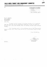
Letter - Re Interview With Management Committee, 18.12.1959
Bob Hymans Collection Bob (Herman) Hymans (a former member of the Royal Netherlands Navy was born in Bloemendaal, Holland on 30th September 1922. During World War II he fought against the Japanese in the Dutch East Indies (now Indonesia) and was imprisoned in Changi and on the Burma Railway. After gaining qualifications as a Ski Instructor, Bob arrived in Falls Creek in May 1950. Working as an Instructor and Supervisor at Bogong Lodge, Bob decided his future was in accommodation. He was successful in negotiating an indenture for land from the State Electricity Commission (SEC). It took Bob two years to build his Grande Coeur Chalet but, tragically, it was burned down in August 1961. Bob also built the first Chairlift in Australia. This was a single chairlift and the structure was built from wooden electricity poles. He was constantly full of new ideas and proposals for the village. Bob Hymans died on 7th July 2007. This Collection of documents and letters tells the story of Bob’s endeavours to develop Falls Creek into the ski village it is today.This document is significant because it documents the Bob Hymans' proposals for Falls Creek..A letter from the Falls Creek Tourist Area Management Committee in relation to a request to operating a portable ski tow.bob hymans, falls creek tourist area, portable ski tow -
 Falls Creek Historical Society
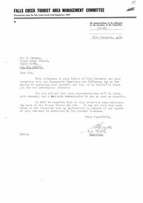
Letter - Request Permission To Use Crawler Tractor Fitted With Blade, 18.12.1959
Bob (Herman) Hymans (a former member of the Royal Netherlands Navy was born in Bloemendaal, Holland on 30th September 1922. During World War II he fought against the Japanese in the Dutch East Indies (now Indonesia) and was imprisoned in Changi and on the Burma Railway. After gaining qualifications as a Ski Instructor, Bob arrived in Falls Creek in May 1950. Working as an Instructor and Supervisor at Bogong Lodge, Bob decided his future was in accommodation. He was successful in negotiating an indenture for land from the State Electricity Commission (SEC). It took Bob two years to build his Grande Coeur Chalet but, tragically, it was burned down in August 1961. Bob also built the first Chairlift in Australia. This was a single chairlift and the structure was built from wooden electricity poles. He was constantly full of new ideas and proposals for the village. Bob Hymans died on 7th July 2007. This Collection of documents and letters tells the story of Bob’s endeavours to develop Falls Creek into the ski village it is today.This document is significant because it documents the Bob Hymans' proposals for Falls Creek..A letter from the Falls Creek Tourist Area Management Committee in relation to a request to operating a crawler tractor fitted with a blade.bob hymans, falls creek tourist area, crawler tractor with blade -
 Falls Creek Historical Society
Letter - Australasian Ropeways Letter Re Magazine & Letter, 05.02.1960
Bob Hymans Collection Bob (Herman) Hymans (a former member of the Royal Netherlands Navy) was born in Bloemendaal, Holland on 30th September 1922. During World War II he fought against the Japanese in the Dutch East Indies (now Indonesia) and was imprisoned in Changi and on the Burma Railway. After gaining qualifications as a Ski Instructor, Bob arrived in Falls Creek in July 1950. Working as an Instructor and Supervisor at Bogong Lodge, Bob decided his future was in accommodation. He was successful in negotiating an indenture for land from the State Electricity Commission (SEC). It took Bob two years to build his Grand Coeur Chalet but, tragically, it was burned down in August 1961. Bob also built the first Chairlift in Australia. This was a single chairlift and the structure was built from wooden electricity poles. He was constantly full of new ideas and proposals for the village. Bob Hymans die on 7th July 2007. This Collection of documents and letters tells the story of Bob's endeavours to develop Falls Creek into the ski village it is today.This letter is significant because it documents plans made by Bob Hymans to develop Falls Creek Tourist Area.This letter was written to Bob Hymans by Vladimir Hájek from Australasian Ropeways 05.02.1960. It discusses plans for a chairlift at Arthurs Seat on the Mornington Peninsula, Victoria. The chairlift was built by Vladimir Hájek, a Czech engineer and opened on 21 December 1960. australasian ropeways, chairlift falls creek, vladimir hájek -
 Forests Commission Retired Personnel Association (FCRPA)
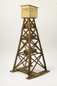
Wooden Model Fire Tower, Tom Coish, Model of Reef Hills fire tower, (5 km south of Benalla), 1957
Victoria once had well over one hundred fire lookouts and firetowers. Fire lookouts, or observation posts, were often just a clearing on a hill or a vantage point, whereas firetowers were definite structures. There are at least three categories of firetowers… (1) tree perches, (2) four-legged towers made of either wood or steel, as well as (3) hilltop cabins and observatories. Many were established by the Forests Commission Victoria (FCV) in the 1920s, but the network was expanded rapidly in response to recommendations of the Stretton Royal Commission after the 1939 Black Friday bushfires. The wooden towers were often built by bush craftsmen like legendary FCV overseer Clem Heather from Orbost. But advances in aerial reconnaissance and radio technology led to the gradual reduction in the number of fixed towers. FFMV now operates 72 firetowers. The CFA, Melbourne Water, Hancock Victorian Plantations (HVP) also operate some, the Army has one at Puckapunyal overlooking the live-firing range. Only two remaining fire towers of this design remain in Victoria (Mt Little Dick and Big Tower in the Mullungdung State Forest). Mt Nowa Nowa and Stringers Knob burnt down in the 2019/20 bushfiresLarge model of an Reef Hills fire tower. Presumably used for instructional purposes. Traditional FCV four legged design with three landings and closed cabin.bushfire, forests commission victoria (fcv) -
 Federation University Historical Collection
Book, Ballarat College of Advanced Education Annual Report, 1983, 1984
The Council President in 1984 was Ian Gordon.Yellow soft covered book. Contents include: Review of College objectives and organizational structure, Nursing, Mining Engineering Education, Physical Education, Ultra Violet Visible Spectrophotometer, Microbee computers, Scanning Electron Microscope, Peter Colville, Thelma Rungkat, Ray Cotsell, Samantha Taylor, Don Fairhall, George Wasyluk, staff resignation of Alan Roberts, Lynette Snibson, Margaret Bowman, John Burrell, Malcolm Mackinlay,Fazal Rizvi, Irene Wasyluk, Wendy Batchelor, Peter Coman, Micro-teaching area, Staff retirement of Geoff Biddington and Mr Rofe, Staff appointment of Richard Dutton, Peter McCarthy, Richard Croggon and Jim Nugent, building of external kiln, Studio Production Ceramics, Nellie Skolnikova, John Hopkins, Sonny Dalimore, Judi Hill, Academic Registry, Staff resignation of Josephine Ryan, Staff appointment of Diane Costello, building of Metallurgy workshop/shed, Beaufort House, new road entrance to campus, ballarat college of advanced education, bcae, mt helen, mount helen, gordon, tippett, dobell, parkin, tippett, crouch, kiln, ceramics, skolnikova, hopkins -
 Bendigo Historical Society Inc.
Photograph - PALL MALL LOOKING SOUTH
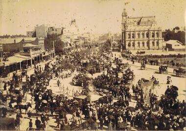
Photo album, cover has blue cover, maroon spine, spine disconnected from pages. 'Album' on front. Sepia photograph stuck inside front cover of album. Image shows large procession heading north up Pall Mall. On RH side of image: Law Courts, Union Jack flag flying overhead. Conservatory Gardens just visible, palm trees not evident, picket fence along footpath. In centre of image: procession with horse drawn floats; float in front of image has large gold coloured ball above an ornate supporting structure. Written on side of ball ' Gold .tained…' (gold contained?) On LH side of image, 'Harry Davey’ and 'F. Davey' written on shop fronts. All shops along Pall Mall have verandahs. Many people are sitting on balconies and rooftops watching the parade. Appears to be approx. 1890’s?bendigo, streetscape, pall mall, bendigo, sandhurst, procession, gold, post office, pall mall -
 Bendigo Historical Society Inc.
Photograph - GOLDEN SQUARE LAUREL STREET P.S. COLLECTION: GOLDEN SQUARE PRIMARY SCHOOL GRADE 2/3 W 1996
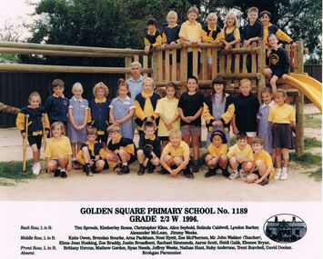
Laminated colour photograph of the Golden Square Primary School No. 1189 Grade 4/5 1996 classes. The photo is taken at a playground. Some of the children are in front of the timber structure and some are standing on it. The children are wearing school uniform. The names are:- Back Row, L to R: Tim Sproule, Kimberley Rosos, Christopher Kline, Alice Seybold, Belinda Caldwell, Lyndon Barker, Alexander McLean, Jimmy Weeks. Middle Row, L to R:- Katie Owen, Brendan Bourke, Arna Packham, Noni Hyett, Zoe McPherosn, Mr John Wakker (Teacher), Elma-Jean Hosking, Zoe Braddy, Justin Broadbent, Rachael Simmonds, Aaron Scott, Heidi Galik, Ebonee Bryan. Front Row, L to R:- Brittany Hercus, Mathew Gordon, Ryan Needs, Jeffrey Weeks, Nathan Hunt, Ruby Anderson, Trent Burchell, David Doolan. Absent:- Brohgan Parmenter. On the right beside the names is an oval picture of the school.education, primary, golden square laurel st p.s., golden square laurel street p.s. collection - photograph golden square primary school no. 1189 grade 2/3 w 1996, tim sproule, kimberley rosos, christopher kline, alice seybold, belinda caldwell, lyndon barker, alexander mclean, jimmy weeks, katie owen, brendan bourke, arna packham, noni hyett, zoe mcpherosn, mr john wakker (teacher), elma-jean hosking, zoe braddy, justin broadbent, rachael simmonds, aaron scott, heidi galik, ebonee bryan, brittany hercus, mathew gordon, ryan needs, jeffrey weeks, nathan hunt, ruby anderson, trent burchell, david doolan, brohgan parmenter -
 Bendigo Historical Society Inc.
Photograph - VIEWS OF BENDIGO: BOTANICAL GARDENS, WHITE HILLS, 1875
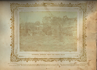
Sepia photograph. View of the Botanical Gardens, White Hills. A path cuts horizontally across the foreground where a young fir tree is growing. Beyond the path there is a small building on the far left, a shed structure with surrounding picket fence, followed by a small cottage and a stand of eucalyptus trees extending to the right. A variety of exotic trees and shrubs both exotic and native border the path. Inscriptions: Printed mount in gold ink 'Views of Bendigo No. 51' on top. 'Botanical Gardens Near The White Hills', 'NJ Caire, Photo, Sandhurst', 'Casey & Wenborn's print', Forbes & Holmes, agents'. These public gardens were first promoted by the Sandhurst Corporation in the year 1965. They cover an area of about 30 acres, and contain many choice and rare plant. The public are admitted everyday in the week from the hours of sunrise to sunset. Mr Gadd is the curator and resides in the gardens. Nicholas Caire (Two copies)Nicholas, J Caireplace, public gardens, botanical gardens, white hills -
 Moorabbin Air Museum
Document (item) - Wamira NIA E37 Documents and drawings
-
 National Wool Museum
Book, Wool Sample, 1936-8
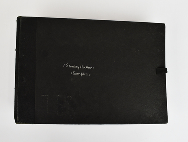
The story of 90 years of wool classing between father & son begins in 1936, when a young boy by the name of Stanley James Hucker walked through the doors of the Gordon Technical School in Geelong. Born in 1921, Stanley was 15 years of age when he began his 3-year course in Wool Classing. 30 years later, Stanley’s second son Denis completed the same 3-year wool classing course. Beginning in 1966, Denis attended the same Gordon Technical School and walked the same halls as his father before him. Stanley finished his course in 1938. He went back to the family farm in Lake Bolac for a brief period before enrolling in the Second World War. At the completion of the war, Stanley returned home and married before gaining a soldier settler allotment, north of Willaura. This enabled Stan to use his wool classing knowledge. He ran between 1,500 and 2,000 sheep for many years, while his wool classer stencil also allowed him to go out and class at various sheds around the area. He held his stencil from 1938 until he retired at the age of 60 in 1981. On retirement, his second son Denis was working in the district, managing a local property while also leasing land himself. Upon his father’s retirement, Denis had the opportunity to lease his father’s farm, an opportunity he could not refuse. Denis had finished his wool classing course at the Gordon Technical School in 1968, graduating dux of his class. He began working with a local contractor and started classing wool in his team. Denis gained a great deal of experience working as part of this team in big sheds of up to 8 stands servicing between 10 & 20,000 sheep. It was not all smooth sailing for Denis however, and he soon learnt an important lesson. Class wool the way you’re taught, don’t listen to the owner standing over your shoulder. At a clip of Corriedales near Casterton, Denis was pushing too many fleeces into the line of fine wool. This resulted in a notice from the Australian Wool Exchange (AWEX) “mixing counts too much, submit three clips for inspection”. Denis was able to submit 3 clips with no further complaints, however, this proved a valuable lesson he would never forget over his long career classing wool. In the early 1980s, when Denis was leasing two properties including his father’s, things were going well until drought struck. February 1983 was the date of the Ash Wednesday bushfires, and saw Melbourne have three days over 40 °C for only the second time on record. This period saw Denis give away farming, turning towards contracting work instead. After the difficult times of the early 1980s, the next two decades were a good time for the sheep industry. 15 micron wool was selling for prices between 4 to 5,000 cents per kilo, double what you’d expect for the same wool in 2022. In 1995 a single bale of wool sold for a million dollars. This was a good time for Denis too. His contracting work saw him employing local shearers and shed staff. His team was involved with the shearing and classing of more than 130,000 sheep. After 20 years of contracting, it was time for Denis to transition into the next phase of his life. He gave up independent contracting, preferring instead to return to being a member of someone else’s team. In 2018, having completed 50 years of wool classing, it was time to call it a day and retire completely. At the annual Gordon Wool School Old Students Association dinner held in 2018, Denis was presented with his 50 years as a registered wool classer stencil awarded by the Australian Wool Exchange (AWEX). This is a rare honour achieved by few. As of February 2020, a total of 430 wool classers had achieved this 50-year milestone. For Denis however, his proudest achievement is achieving 90 years of wool classing with his father. The National Wool Museum is proud to share the collection of objects gained from 90 years in the wool classing industry by Stanley and Denis. This ranges from Stanley’s first stencil and Wool Sample book, started when he first attended the Gordon in 1936. The collection concludes 90 years later with Denis’ 50 years of wool classing Stencil. The collection contains many more objects, all telling the story of these 90 years, and the hard work invested by this dedicated father and son duo.Large black bound book with ribbon for fastening containing 12 double-sided blue pages. Pages have several samples of shorn wool mounted and annotated to include information such as specific breeding, shearing faults, and geographical area. The book concludes with four pages without wool samples. Two of these pages relate to plans for a shearing shed and other industry related structures. The final two-pages relate to the anatomy of a sheep. Wool sample books were constructed by Wool Classing students at the Gordon Technical School as examples of what to look for when classing wool. The students were tasked with constructing these books with samples they retrieved themselves from several different farms and animals. The book would serve as a reference point for the wool classers throughout their years in the field, it was always on hand to refresh knowledge. This book was constructed by Stanley Hucker over his schooling at the Gordon between 1936 and 1938Front Cover. Handwritten, White Ink "Stanley Hucker / Samples"90 years wool classing between father & son, wool classing, gordon technical school -
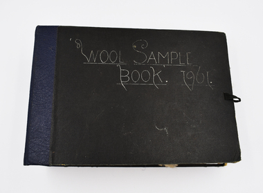 National Wool Museum
Book - Wool Sample, 1961
The donor, Brian Licence, assembled this Wool Sample Book while studying at the Gordon Institute from 1960-62. Brian studied Wool Classing and worked for a decade in this profession before moving to Melbourne which required him to change careers. The National Wool Museum accepted a donation from Brian in 2022 of several mementoes relating to his career in the wool industry. This wool sample book joins a collection of 8 others within the museum’s collection, with the oldest dating to 1870 at the time of writing in 2022. Large black bound book with ribbon for fastening containing 12 double-sided blue pages. Pages have several samples of shorn wool mounted and annotated to include information such as specific breeding, shearing faults, and geographical area. The book concludes with four pages without wool samples. Two of these pages relate to plans for a shearing shed and other industry related structures. The final two-pages relate to the anatomy of a sheep. Wool sample books were constructed by Wool Classing students at the Gordon Technical School as examples of what to look for when classing wool. The students were tasked with constructing these books with samples they retrieved themselves from several different farms and animals. The book would serve as a reference point for the wool classers throughout their years in the field, it was always on hand to refresh knowledge. This book was constructed by Brian Licence over his schooling at the Gordon between 1960 and 1962. Front Cover. Handwritten, White Ink "Wool Sample / Book. 1961”wool classing, gordon technical college, brian licence -
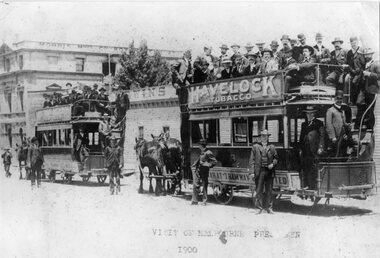 Ballarat Tramway Museum
Photograph - Black & White Photograph/s - set of 2, 1900
Yields information about the nature of a visit to Ballarat by Melbourne pressmen and the buildings in the background at the time. Also shows the dress of the visitors at the time. Various sources - ex photo held by the Ballarat Historical Society. Also shows the condition of the trams at the time.Black and white print of a photograph of two crowded horse trams in Lydiard St North. Ballarat, titled "Visit of Melbourne Pressmen 1900". Has Morris Manufacturing Company building in the background. Both horse trams, No.9 nearest to camera, have "Havelock" Tobacco roof advertisements. Behind the trams is Irwin's Provincial Hotel, when it was a timber structure. Print made from a copy negative held in the Ballarat Historical Society collection???? 2nd copy added 8/11/2005 from BTM collection of photos in mess room. 2785.1 - as above, but photographed from an album - shows the full length of horse tram No. 9 and has number TR4 in bottom right hand corner. 2785.2 - as above but cropped on sides - cropped out rear of horse tram 9. 2785.1 & .2 added 12/7/2009, ex William F Scott. See Email from Max Harris 12/8/042785.1 - top on rear in ink - "Ballarat Visit of Press men , 1900 Sydney Harvey photo". 2785.2 - in ink on rear "18a)", "Visit from Melbourne Press 1900, opposite Ballarat Railway Station". In bottom right hand corner "Sydney Harvey" and "William F Scott" address label.tramways, trams, horse trams, melbourne pressmen, ballarat, tram 9 -
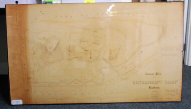 Bendigo Historical Society Inc.
Map - CONTOUR PLAN OF THE GOVERNMENT CAMP SANDHURST 1854, 1994
Contour map (copy) of the Government Camp Sandhurst, 1854. Map is mounted on coreflute and laminated. Written in bottom righthand corner 'Contour Plan of the Government Camp, Sandhurst. Dec 1854. Signed by Richard Larritt, Assistant Surveyor, 11th December 1854.' Shown on map: Pall Mall, Bendigo Creek, Commissioner's Gully, View Place (now View Street), Post Office, Bank of Victoria, District Surgeon, Sandhurst Fire Brigade, Police Hospital, Flagstaff, Gold Office, License Shed, Military Barracks, Stables, Commissioner's Buildings, Police Office. Old Cemetery, Garden. Reference on righthand side: 'Stone or brick buildings are tinted in crimson. Wooden buildings tinted in Indian Ink. Tents and other temporary structures tinted in Burnt Sienna.' Scale of Chains, on bottom of map. Sticker on bottom left hand corner and back of map ' Presented by Survey and Mapping, Victoria, 7th Octber, 1994'.map, bendigo, government camp, pall mall, bendigo creek, commissioner's gully, view place (now view street), post office, bank of victoria, district surgeon, sandhurst fire brigade, police hospital, flagstaff, gold office, license shed, military barracks, stables, commissioner's buildings, police office. old cemetery, garden. , survey and mapping victoria. sandhurst, bendigo. -
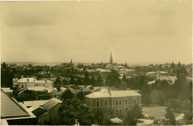 Kew Historical Society Inc
Photograph, J F C Farquhar, Bird's Eye View Looking North, 1891
At the beginning of the 1890s, the Kew businessman and Town Councillor, Henry Kellett, commissioned J.F.C. Farquhar to photograph scenes of Kew. These scenes included panoramas as well as pastoral scenes. The resulting set of twelve photographs was assembled in an album, Kew Where We Live, from which customers could select images for purchase.The preamble to the album describes that the photographs used the ‘argentic bromide’ process, now more commonly known as the gelatine silver process. This form of dry plate photography allowed for the negatives to be kept for weeks before processing, hence its value in landscape photography. The resulting images were considered to be finely grained and everlasting. Evidence of the success of Henry Kellett’s venture can be seen today, in that some of the photographs are held in national collections.It is believed that the Kew Historical Society’s copy of the Kellett album is unique and that the photographs in the book were the first copies taken from the original plates. It is the first and most important series of images produced about Kew. The individual images have proved essential in identifying buildings and places of heritage value in the district.This panoramic view was probably taken from the roof of Xavier College. It invites the viewer to look down on the buildings and streets of Kew, and across to the distant horizon. Mansions and solid bourgeois villas dominate the view of Charles and Wellington Streets. The imposing spires of the Presbyterian and Methodist Churches, built in one of the highest areas of Kew, can be seen in the distance. In the foreground, the photographer includes three significant mansions: Molina, Roxeth and Elsinore. Molina, in the foreground, and the group of weatherboard buildings in its yard was used at this stage for the privately operated ‘Kew High School’ (founded 1872). Roxeth, the home of Herbert Henty can be identified by its distinctive four-sided tower. All three buildings are now part of Trinity Grammar. Other built structures observable in the photograph include Wilton (now the Kew RSL), designed by Guyon Purchas for Dr William Walsh in 1886, and the only known image of the Prospect Hill Hotel prior to the renovation of 1935. Bird's Eye View Looking Northkew illustrated, kew where we live, photographic books, henry kellett -
 Kew Historical Society Inc
Photograph - Campsite near Bogong, c.1926
Henry Beater Christian (1886-1962) , was a descendant of one of the earliest settler families in Kew. Employed at the Kew Asylum as a 'public servant', he was a skilled amateur photographer, photographing numerous scenes in Kew and on his travels around Victoria. The majority of his photographs date from 1916 to 1929. His finest photographs are housed in two photograph albums. Digital copy of a photograph from page 34 of the 47-page photograph album containing 261 gelatinous silver images, loaned by Diane Washfold with permission given to digitise and hold a copy in our collection. John Chapman has written in 'Bushwalking Clubs - A Brief History', about the establishment in Victoria of the first bushwalking club in 1888, and the popularisation of bushwalking during the interwar period. Henry Christian's 'walks' appear to have been undertaken solely or with a companion/s. This black and white photo is part of a group of photos taken in the Victorian High Country. The page is labelled 'Bogong ****' and includes photos of landscapes, individuals, and built structures. This evocative, small black and white photo is of a campsite near Bogong in Victoria in the mid-1920s. Enclosed in an oval shape, which the photographer clearly used for what he considered his best images, the photograph includes pack and saddled horses and travellers."BOGONG [illegible]"henry beater christian (1886-1962), landscape photography, christian-washfold collection, photograph albums, bushwalking, northeast victoria, victorian high country, bogong -
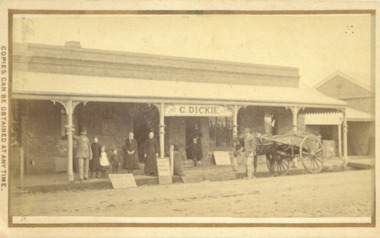 Bacchus Marsh & District Historical Society
Photograph, George Dickie Bakery Main Street Bacchus Marsh 1883
George Dickie arrived in the Bacchus Marsh area around 1857. In 1863, he married Ellen Ross Anderson, and after five years of farming in Coimadai, they moved into Bacchus Marsh and established a business. In 1866 he bought the bakery business which had been established by James Boatwood and later conducted by William Watson. This business was in Main Street and is shown in this image during the time it was owned and operated by George Dickie. Ellen and George Dickie had seven children, two sons and five daughters. In his later years he changed the business into a general store and also engaged in grain dealing. He died in 1904 but the business was carried on by his sons until sold in March 1916 to a Charles Medling from Numurkah. The building was later demolished in 1927 to make way for four new shops.Small sepia 'carte de viste' style unframed photograph on card with gold border framing photograph. Housed in the Jeremeas Family Album which contains photographs of Bacchus Marsh and District in 1883 by the photographers Stevenson and McNicoll. The picture shows the business of George Dickie which was located in Main Street Bacchus Marsh. The building is a brick or stone structure with a verandah along the entire frontage of the building. Standing in front of the building is a group of adults and children. On the far left is a man wearing a dress coat and hat. He is possibly Mr. George Dickie the owner of this business. To his left are some younger and older children, and a woman, possibly Mrs DIckie. In the background in the doorway is a young boy with woman behind him. On the right of the picture on the street is a man standing alongside a horse and cart. Some advertising signs are leaning against the shop, footpath and verandah pillar. One of them says 'Chaff, Oats, Bran'. Printed On the front: Stevenson & McNicoll. Photo. 108 Elizabeth St. Melbourne. COPIES CAN BE OBTAINED AT ANY TIME. On the back: LIGHT & TRUTH inscribed on a banner surmounted by a representation of the rising sun. Copies of this Portrait can be had at any time by sending the Name and Post Office Money Order or Stamps for the amount of order to STEVENSON & McNICOLL LATE BENSON & STEVENSON, Photographers. 108 Elizabeth Street, MELBOURNE. stevenson and mcnicoll 1883 photographs of bacchus marsh and district, bakeries, shops bacchus marsh, george dickie 1831-1904, dickie family bacchus marsh -
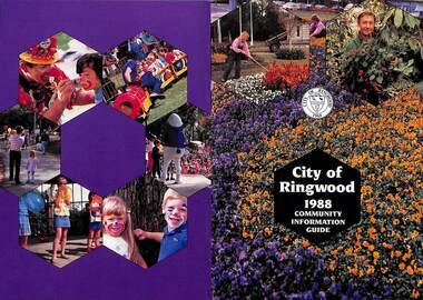 Ringwood and District Historical Society
Booklet, City of Ringwood 1988 Community Information Guide, 1988
Community information booklet issued by City of Ringwood for 1988 - covering the facilities and activities of the Ringwood Council and other local organisations and associations. Cover photographs: Front - Floral displays at Clock Tower and a scene at Council nursery; Back - Activities at Ringwood Festival held at Ringwood Lake in April each year.CONTENTS: (page no.) After School Activities Programme 23 Aged Services 21 Bicentennial 15 Building Information 29 By-Laws and Traffic Regulations 31 Caravans/Mobile Homes 31 Chief Executive's Message 10 Children's Services 22 Churches 40 Civic Centre 4 Committees of Council 5 Community Plan 15 Community Services 35 Corporate Management Structure 11 Council Meeting Dates 4 Council Representatives 8 Councillors 6 & 7 Disabled Persons Facilities 42 Dogs 31 Domiciliary Care 24, 25 & 26 Elderly Day Care 44 Elderly Persons Units 29 Emergency Telephone Numbers 53 Employment Opportunities in Ringwood 26 European Wasps 28 Family Day Care 22 Finances 17 Fire Hazards 31 Future Leaders 16 Golf Course 34 Home Handyman Services 25 Home Help 26 Immunisation Programme 27 Incinerators 32 Knaith Road Child Care Centre 22 & 23 Library 30&31 Maternal & Child Health Centre 30 Mayoral Message – Cr. John R. Caffyn 3 Meals on Wheels 24 Members of Parliament 9 Playgroups 33 Pre-Schools 53 Primary Arterial Road Network in Ringwood 13 Rates—New Collection Service 18 & 19 Ringwood Aquatic Centre 14 & 15 Ringwood Bypass Road 12 Ringwood Convention & Performing Arts Centre 33 Ringwood District Centre Structure Plan 12 Rubbish Collection Service 35 & 36 Schools 56 Youth Outreach Worker 20 rinx -
 The Beechworth Burke Museum
Photograph, Unknown c.1930s
This image shows Bethanga Bridge, which was constructed between 1927 and 1930 in Albury, NSW. The bridge was a necessity due to the building of the Hume Dam (Wier), 1919-1936. Bethanga Bridge is a long, nine-span, riveted-steel, variable depth, Pratt Truss road bridge of nine principal spans of 82 metres and a total length of 752 metres over the flooded valley of the Murray River, now part of Hume Reservoir. Because of its unique location, over the waters of a dam with the border running down the centre of the body of water, the Bethanga bridge is the only built structure shared by both New South Wales and Victoria. It was built 1.6 kilometres upstream of the dam and in 1961 was raised 300mm, with a concrete deck replacing the original wooden deck. The State Rivers and Water Supply Commission of Victoria and the New South Wales Department of Public Works were responsible for the construction works for the Hume Weir under the River Murray Waters Agreement. It is apparent that a similar joint arrangement was made for the construction of the Bethanga Bridge as part of the Hume Weir works.This photograph of the Bethanga Bridge is of historical significance as it showcases the architectural skills of Percy Allen and Vincent Packer. Additionally, it reveals the environmental landscape of the 1920s-1930s, is linked to the Hume Dam and both New South Wales and Victorian heritage. Unmounted black and white rectangular photograph. Reverse: 1997.3196 84-20-3bethanga, bethanga bridge, hume dam, pratt truss, murray river, hume weir, transportation -
 The Beechworth Burke Museum
Geological specimen - Amazonite, unknown
Amazonite is classed as a Tectosilicate and is part of the Feldspar group of minerals. Amazonite forms in a triclinic crystal structure and its chemical formula is K(AlSi3O8). In appearance, Amazonite can range from shades of green to green blue to blue, and often with white streaks or veining. The greenish colour is believed to come from the small amount of lead contained in its composition. Amazonite is named after the Amazon River due to its colour and similarities to another rock found along the riverbanks, although Amazonite is not actually found at or near the Amazon. Although less commonly used in jewellery today, Amazonite has been mined and used by humans for thousands of years and Amazonite jewellery from at least 2000BCE have been discovered in North Africa. Amazonite is found in many locations around the world including Brazil, Peru, Ethiopia, Canada, Russia, Mozambique, Myanmar, Pakistan, China, Madagascar, and the United States of America. This specimen most probably comes from the U.S.A., Amazonite is found in several US states particularly in Colorado, Virginia, Pennsylvania. This specimen is of both scientific and historic significance as a striking blue green example of Amazonite mined prior to 1868 in the United States of America, most likely from Colorado, Virginia, or Pennsylvania. These three states are all locations of significant Amazonite deposits. This specimen is part of a larger collection of geological and mineral specimens collected from around Australia (and some parts of the world) and donated to the Burke Museum between 1868-1880. A large percentage of these specimens were collected in Victoria as part of the Geological Survey of Victoria that begun in 1852 (in response to the Gold Rush) to study and map the geology of Victoria. Collecting geological specimens was an important part of mapping and understanding the scientific makeup of the earth. Many of these specimens were sent to research and collecting organisations across Australia, including the Burke Museum, to educate and encourage further study.A palm-sized Feldspar mineral specimen from the Tectosilicate class in shades of blue-green with white veining.Existing label: green/blue Feldspar / "amazonite" / possibly USA geological specimen, geology, geology collection, burke museum, beechworth, tectosilicate, amazonite, feldspar, triclinic crystal structure, amazonite usa, amazonite colorado, amazonite virginia, amazonite pennsylvania -
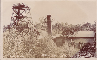 The Beechworth Burke Museum
Postcard, c1900-1912
This object is a photographic postcard showing some of the above-ground structures of the Golden Bar mine in Chiltern, including a building with a smokestack and the poppet head which is used to haul equipment, materials, and men above or below ground. The Golden Bar site, mined by the Golden Bar Mining Company which was formed in 1901, managed to yield approximately 12,453 oz of gold before work stopped in 1912 - it was one of the principal mines in the area, as well as the deepest and one of the richest. The text on the postcard was handwritten by H.Gordon (?) to Issy (?), to show the mine where he presumably worked as he promises to take them 'above and below'. The postcard can be approximately dated to between 1901-1912. It is stated that after 1902 Kodak added the line on the postcard backs to divide into correspondence and address sections as seen on the reverse of this object. In addition, there is also a similar Kodak photographic postcard in the Burke Museum collection that is dated to 1908 and has the same specific font type and manufacturer markings (see references for link). Lastly, the Golden Bar mine ceased operations in 1912 so the photograph was likely taken prior to this. This photographic postcard is a rare and fair conditioned representation of one of the most significant gold mines in the Chiltern area, showing the above ground structures at the time it was being actively mined. This postcard also holds social significance as a snapshot of working life in the gold mining rush of Victoria, and a personal record of one of its miners. A sepia rectangular postcard printed on card.Obverse: Dudley Studio / Golden Bar. Chiltern Reverse: BMM 8034 / Post Card. / Correspondence. / Address Only. / Kodak. Austral. 110 / My Dear Issy (?), / A card only, to show (?) the mine / and when you come down I will / take you above and below, / All (...) love, me to. Has the baby / gone home yet Heini (?) wants to know / give my love to Syd when next you write / Your loving (...), H. Gordon (?)photographic postcard, postcard, chiltern, golden bar mine, golden bar mining company, dudley studio, kodak -
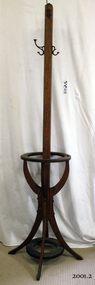 Flagstaff Hill Maritime Museum and Village
Coat rack
A hat coat and umbrella stand is a device used to store hats and often coats on, and umbrellas within. Some catalogues in Europe marketed this furniture as a portmanteau from the French words Porter (carry) and Manteau (cloak). The front hall was the introduction to the house, and as such was an important part of the Victorian home. Furnishings were selected not only to make it a useful place to hang a hat and coat, store an umbrella and leave a calling card but also to show family wealth, social position and knowledge of current styles. A hall stand or a hat rack was the most important piece of furniture in homes at this time. New and more elaborate designs began to appear about 1840, as homes became larger and social visits became more structured. Usually made of wood and standing at least 1.5 meters tall, they have a single-pole making up most of the height, with a sturdy base to prevent toppling, and an array of lengthy pegs or hooks at the top for placement of hats. Smaller houses had smaller front halls, so a single-pole type as by the 1920s houses had become smaller. A household furniture item possibly from the 1920s that was common in houses from the early 1840s, it's significance is social, demonstrating how furniture trends change over time with the more elaborate the item the more social standing was attributed to the owners' position in society. even today persons association and ownership with inanimate objects tend to represent their social standing along with their financial and community acceptability. Coat rack with four curved legs, circular holder for umbrellas and walking sticks. Four metal hooks, screwed onto main column of stand. Condition: one curved leg broken. 2 hooks broken.Noneflagstaff hill, warrnambool, shipwrecked-coast, flagstaff-hill, flagstaff-hill-maritime-museum, maritime-museum, shipwreck-coast, flagstaff-hill-maritime-village -
Glenelg Shire Council Cultural Collection
Certificate - Certificate - Historic Buildings, Portland Town Hall, 1974
From the Victorian Heritage Register: The foundation stone of the original Portland Town Hall was laid by William Learmonth on 21st September, 1863 following a competition and subsequent public controversy over the permitted entry of architect John Barrow. The conservative classical design of municipal surveyor Alexander Ross was preferred and this axially planned design with central council chamber and side offices fronted by a fine axed pedimented gable entablature of basalt and Tuscan Doric pilasters was completed by 24th may 1864. The old Town Hall is one of a distinguished group of public buildings in Portland and an interesting example of conservative classical architecture of the first years of settlement in western Victoria. The basalt structure was partially erected of stone from the Portland stockade and has significant historical associations with local Government administration in the district. The Town Hall is the most impressive work of Alexander Ross, a surveyor architect whose career remains largely undocumented. The old Town Hall at Portland has been discreetly extended at the rear to provide additional meeting room accommodation. The premises are no longer used for local government administration.A4 sized certificate demonstrating Portland Town Hall's special significance to the state of Victoria & inclusion on the Historic Building Register. Singed by Robert Maclellan, Minister for planning & Historic Buildings Council Chairperson. Red seal attached, bottom right.portland town hall, history house, heritage register, historic buildings, certificate -
Federation University Historical Collection
Booklet - Booklet - Syllabus, Government Technical School, Hobart, Syllabus, 1892, 1892
The Tasmanian Parliament made provision for 'the teaching of the principles of technical education' in the Education Act (1885). Regulations specifying courses of instruction and establishing a committee of Technical Education followed in 1887. The first government Technical School opened in Hobart in 1888, offering evening classes in technical art and applied mechanics. Two months later a school was established in Launceston. Small classes were also held in regional centres and Schools of Mines were established in Zeehan, Queenstown and Beaconsfield. Curricula quickly expanded to include subjects ranging from mineralogy and metallurgy to commercial economy, beginning the long tradition of directly linking the schools with the interests of business and industry. The Technical Schools largely worked independently, with varying degrees of success, until 1916 when a Commission of Inquiry recommended the integration of technical education into the state education system. The outcome was a new Technical Education Branch, formed to administer Technical Schools and Schools of Mines and to provide a structured technical education system, comprising distinct trade certificates and applied sciences, engineering and arts diploma courses. Pale orange soft covered booklet.hobart, technical school, syllabus, malcolm kennedy, a. mault, r.s. pemberton, a. morton, a.j. taylor, henry lamb, j. mcmeekin, j.h. hunt, j.r. trantham-fryer, f.g. howell, w. middleton, trevor russell, j.f. echlin, w.f. ward, archibald park, a paton miller, committee members of technical education, department of art, department of mathematics, department of engineering, department of commercial economy, department of geology mineralogy mining, department of chemistry, department of pharmacy, department of veterinary science