Showing 173680 items
matching street
-
 Eltham District Historical Society Inc
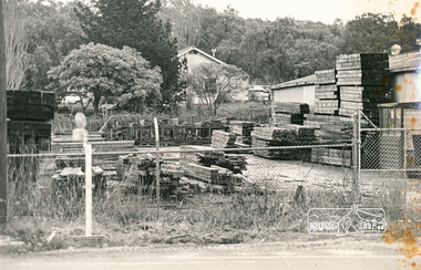
Photograph, N. J. Tillings Timber Factory, 15 June, 1975, 15/06/1975
Fence yard with piles of timber. Weatherboard building in background. This is one of 7 B/W 8x10 inch photos with notes on obverse by Dick Crichton. Accompanying letter from Florence Chrichton 2013 : "Originally sent to Shire of Eltham Engineer, Mr. McDonald. [These photographs were part of their campaign to the Shire of Eltham in 1975] claiming that the zoning regulations were being breached by the occupants of various factories in the nearby light industrial zone [Brougham Street, Eltham] - to the detriment of those living in adjoining residential zones, and that, despite .. earlier objections and complaints, nothing was done about it." 1 black and white photograph printed with white borderInscribed on back: "Ryans Yard, Susan Street, (part owned by Tillings) showing Tillings surplus baulk timber (at extreme right and left) before milling. This timber is often also stored in Peel Street. Majority of baulks are stored at rear or side of Tillings main premises. Eltham High School object to transportation of this timber along Bell and Susan Streets in large semi-trailers. Trucks backing in and out of Tillings cause frequent traffic jams in Bridge Street (often around 8am)." industrial estate, brougham street, eltham, 1975, bolton street, dick crichton, n.j. tillings, timber factory, shire of eltham, susan street, bell street, eltham high school -
 Port Melbourne Historical & Preservation Society
Photograph - Graham Street Rockery
The rockery and buildings in this area of Graham Street were demolished in the 1970s when the Graham Street overpass was constructed.View of ornamental reserve (rockery) in Graham Street with many people, men, women and children standing in front of the rockery and a number of two-storey buildings in the background. The decorative lights of the Maskell & McNab Memorial are visible within the rockery. There is a bicycle leaning against the wall of the rockery at the centre of the image.graham street, parks and gardens, frederick william maskell, james mcnab, maskell & mcnab memorial -
 Whitehorse Historical Society Inc.
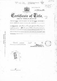
Document, Certificate of Title, 1/06/1951
Certificate of Title Vol 7583 Fol 060, being Lot 72 on Plan of Subdivision No 6626, 50 Burnett Street, Mitcham, with Plan of Subdivision No 6626 including Burnett Street, Thomas Street, bordered by Cook Street and Cook Street and Whitehorse Road, Mitchamburnett street, mitcham, no 50, thomas street, cook road, whitehorse road -
 Bendigo Historical Society Inc.
Postcard - Alice McGregor Postcard Collection, 1900 - 1920
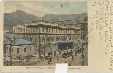
Alice McGREGOR Born: 1908; unknown parents. Possibly adopted by the Salter family? Electoral Roll 1936: Highland Terrace Kangaroo Flat. Alice Mary Salter and William Robert Salter living together; presumed to be sister and brother. William Robert Salter was killed in a MVA in Bendigo in 1937 aged 26. In Victoria in 1938, Alice Mary Salter married James Thomas McGregor (born Victoria 1917, died Victoria 1983, buried Fawkner Cemetery) Lived: 1968; 22 Wade Street Golden Square Alice McGregor Died: 1999 aged 91 at Anne Caudle Centre, Bendigo Buried: Kangaroo Flat Cemetery See additional research. Postcard Album of Alice McGregor contained 86 post cards.Postcard Album of Alice McGregor containing 86 post cards. See 1400 Colour photo of the Railway Station, Alderley Street, Cape Town, South Africa. Horse drawn vehicles and pedestrians on the street. kground Addressed to Miss A. Stapleton, Arcade, Bendigo, Victoria, Australia Sender - Mrs. E.R. De Low, Hex River, Cape Colony, S. Africa Not dated postcard, collector, alice mcgregor -
 Old Colonists' Association of Ballarat Inc.
Photograph - Photograph - Colour, Ballarat Old Colonists' Association Homes, Charles Anderson Grove, Ballarat
HISTORY OF THE BALLARAT OLD COLONISTS' ASSOCIATION HOMES AT CHARLES ANDERSON GROVE, LAKE GARDENS One of the original objectives of the Association was “to provide the shelter of a house for those Pioneers of the Goldfields whom the reverses of fortune have deprived of the means of procuring the comforts of life in their declining years.” While the first home at Charles Anderson Grove was built in 1925 the Association had previously provided relief for needy pioneers from the time it was formed in 1883. Relief included monthly monetary payments, loads of firewood, medical assistance and distribution of Christmas boxes of groceries to deserving pensioners and in some cases payment of burial costs. Records indicate that in September 1922 three of the pensioners being assisted by the Association were accepted as residents in the newly erected Hassell Homes in Gillies Street (now demolished-opposite the High School). The first site for an Asylum for Indigent Members of the Old Colonists' Association was temporarily reserved from sale in October 1891. The site was approximately 28 acres in area in Mt Clear nearly opposite Midvale Shopping Centre in Main Road. The site was heavily timbered and when cleared over 260 tons of wood was sold to the Woah Hawp Gold Mining Company. A set of gates were erected but no homes built, although a plan for this reserve was drawn which showed twenty buildings ranging from one to four unit per building. The reserve was revoked in November 1909. The second site temporarily reserved in November 1909 as an Asylum was in Alfredton and consisted of some 7 acres and was adjacent to land reserved for an Abattoirs for the Ballarat Council. The reserve was revoked in February 1912 as it was deemed more appropriate to be added to the Abattoir site. Council suggested four (4) other sites in exchange for this land and they were inspected by the President, Vice President and Secretary on 22 December 1912. The first site inspected was land on the west side of Creswick Road opposite the brick kilns (now occupied by the showgrounds and oval). The land was described as being good quality, well fenced, no trees, good drainage and ample acreage but some distance from trams. The second site was Perry Park which was described as being good land, well fenced, having frontage to Gillies Street, good drainage and about 26 acres (but subsequently reduced to 10 acres). It was closely planted with Pinus Insignias and Wattle and had easy access from the Botanic Gardens tram. The third site was the North West portion of Victoria Park (corner of Sturt and Gillies Street) and was described as good land, well fenced and drained and well located. The fourth site was the South West corner of Victoria Park and known as Pound Paddock (corner of Winter Street and Gillies Street). It was considered to be low lying and too close to the Abattoir, and was also a considerable distance from trams. While the third site was recommended as the most suitable for the erection of homes it was considered unwise from the point of view as citizens to reduce the acreage of the park and therefore it was recommended that the Perry Park site be asked for as the most acceptable to the Association for the building of homes. The site was eventually temporarily reserved for an Asylum for Indigent Members of the Association in April 1914 with the gates from Mt Clear having been removed to the site a year earlier and eventually erected in 1917 for £12.10.0. In the same year the first 290 pine trees were advertised for removal in July and sold for £16. A sign indicating that the site was reserved for the erection of cottages was erected in September 1917. Stripping of the wattle bark (for tanning) and the cutting of the wood occurred in November 1918 with the land then being leased until it was required for the construction of the first homes in 1924. While the site was the third to be reserved it was the only one which was used for its intended purpose. It was named as Charles Anderson Grove in honour of Charles Anderson who joined the Association in 1918 and was President of the Association from 1942 to 1944. A number of cottages in the Ballarat Old Colonists' Association Retirement Village of Gillies Street, Ballarat.charles anderson grove, old colonists' club, ballarat, old colonists' association, old colonists' homes, retirement village -
Glen Eira Historical Society
Document - Elizabeth Street, 22, Elsternwick
A two page black and white copy of a Caulfield Conservation Study by Andrew Ward, dated 09/1994, on the house at 22 Elizabeth Street. The study includes an architectural description of the building, a brief history of ownership, a statement of significance and a black and white photograph (101mm x 154mm) of the exterior of the house.elizabeth street, elsternwick, historical buildings, victorian style, edwardian style, rippon lea, sargood frederick sir, bent thomas, elsternwick urban conservation area, stephens nettie, dickson william, architectural features, ward andrew -
Glen Eira Historical Society
Document - Elizabeth Street, 56, Elsternwick
A one page typed research report on 56 Elizabeth Street, Elsternwick, dated 01/01/1989 and produced by the Brighton Historical Society. The report includes a brief history of the owners and occupancy of the house and of the area. The file also includes one page of undated, unattributed, handwritten working notes.elizabeth street, elsternwick, davis peter, davis street, sargood mr, ripponlea, bent thomas sir, bent street, gordon street, barlow george f s, brown george h c, collis-brown george, collis-brown mr, weickhardt e c, collis-brown l g, collis-brown laurie, burke v j, bullock hilary, landells rosalind, brighton historical society -
 Greensborough Historical Society
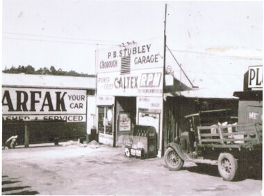
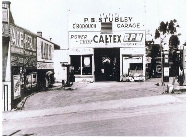
Photograph - Digital Image, Stubley Garage - external view, 1946_
Stubley Garage 1946. The Stubley Group began in 1946 when Purcell Stubley purchased a site with petrol bowsers in Main Street from 'Snowy' Jessop. In 1948 Purcell began building the new Stubley Motors, working round the old site to keep the business operating. It was completed in 1951.Digital copy of black and white photographpurcell stubley, stubley motors, stubley group greensborough -
 Greensborough Historical Society
Photograph - Digital Image, Stubley Garage, 1946_
Stubley Garage 1946. The Stubley Group began in 1946 when Purcell Stubley purchased a site with petrol bowsers in Main Street from 'Snowy' Jessop. In 1948 Purcell began building the new Stubley Motors, working round the old site to keep the business operating. It was completed in 1951.Digital copy of black and white photographpurcell stubley, stubley motors, stubley group greensborough -
Glen Eira Historical Society
Document - Wimbledon Tennis Courts
This file contains one item. Typed notes on Wimbledon Tennis Courts Alexandra Street St. Kilda East. Included is extra research by Margaret Dunbar about tennis courts and Wimbledon Court flats. Further research included about Holmbush Independent Primary School by Claire Barton.dunbar margaret, barton claire, alexandra street, st. kilda east, katos spero, bickham mr., mairs mrs., wimbledon court, masada hospital, holmbush school, balaclava road, tennis courts, tennis -
 Port Fairy Historical Society Museum and Archives
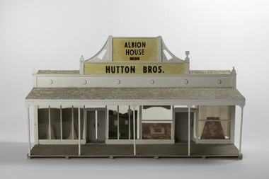
Mixed media - Model, Albion House, early 1970`s
This model was part of a panorama of 11 pieces designed from drawings in an 1892 almanac Printed by Port Fairy Gazette. The panorama was used in the History Society rooms in Bank St Port Fairy on an extended mantel piece, before the Museum and Archives were relocated to Gipps Street Port FairyThis model was made as a part of an eleven piece panorama of the streetscape of Port Fairy in 1892. By a local resident of the town.Small hand made 3D model of a shop front from the 1892 AlmanacAlbion House 1854 Hutton Bros.sackville street, model, mewkill, almanac, albion house, bank street -
 Sunbury Family History and Heritage Society Inc.
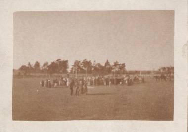
Photograph, 8th August 1917
The people were attending a memorial service which took place on the local Sunbury sports ground in Evans Street during World War 1. The local sportsmen's band entertained the crowd at the event, which commemorated the servicemen who had lost their lives during World War 1. Many young men from Sunbury enlisted and fought on battlefields during World War 1.A non-digital sepia photograph with a cream frame of a crowd of people standing in the centre of a sports ground.sportsmen's band, memorial services -
 Port Melbourne Historical & Preservation Society
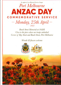
Programme, Port Melbourne Anzac Day Commemorative Service 2022, 25 Apr 2022
Distributed during the Beach Street, Port Melbourne service Monday 25 Feb 2022.The four page program has a white cover with the image of a field of poppies across the lower section. It was produced in support of our Returned Services League for the Port Melbourne Anzac Day Commemorative Service held on Monday 25 April 2022 at 10.00 am at the Beach Street Memorial.the information "Close to the piers where our troops embarked Corner of Bay & Beach Street, Port Melbourne. Wreath & flowers welcome" is inscribed on the cover while inside has the Order of Service.anzac day, rsl, returned services league -
![Toast 25-5-1986 [Hallatrow]](/media/collectors/550653872162f11fb04854aa/items/5e3037ba21ea6717786eae87/item-media/5e3038b121ea6717786f92e1/item-fit-380x285.jpg) Kew Historical Society Inc
Kew Historical Society IncDocument, Toast 25-5-1986 [Hallatrow], 1986
Hallatrow is located at 6 Holroyd Street Kew. It was the home of Thomas Brodribb. The notes were written by his descendant and recall his family's occupation of the house.A manuscript, written by Jim Brodribb, the grandson of Thomas Brodribb, the original owner of Hallatrow, recalling his family's years at Hallatrow (now 6 Holroyd Street in Studley Park.) hallatrow - 6 holroyd street - kew )vic), historic buidlings - studley park - kew (vic) -
Federation University Historical Collection
Photograph, Ballarat State Offices, 1980s
This building is known locally as the glass houseBallarat State Offices on the corner of Mair Street and Doveton Street North.ballarat state offices, glass house -
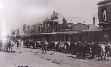 Glenelg Shire Council Cultural Collection
Photograph - Photograph - street scene, Portland, n.d
Street scene with a man herding a bullock train down a street in Portland.portland, street scene, bullock train, farming -
Port Melbourne Historical & Preservation Society
Plan - Raglan Street from Williamstown Street to Ross Street, 14 Mar 1893
Plan of Raglan Street from Williamstown Road to Ross Street, 1893engineering - roads streets lanes and footpaths, town planning, town clerks, mayors, arthur victor heath, james john bartlett -
Port Melbourne Historical & Preservation Society
Plan - Williamstown Road from Farrell Street to Derham Street, 1893 - 1919
Plan of Williamstown Road from Farrell Street to Derham Street 1893.engineering - roads streets lanes and footpaths -
Port Melbourne Historical & Preservation Society
Plan - Proposed crossing, Rouse Street at Nott Street, George Kelly, Borough Surveyor, 27 Oct 1864
Place of Proposed Crossing in Rouse Street (Corner Nott Street) PlanGeo. Kelly, Cr.(?), Borough Surveyor, Sandridge, 27-10-1864engineering - roads streets lanes and footpaths, george kelly -
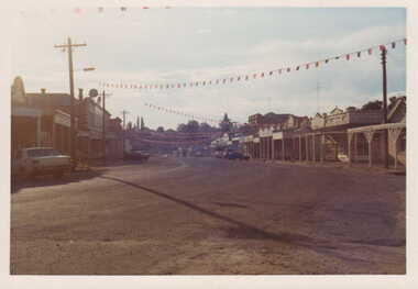 Clunes Museum
Photograph
CELEBRATIONS IN CLUNESCOLOURED PHOTOGRAPH OF CLUNES MAIN STREET WITH FLAGS ACROSS FRASER STREET.local history, photography, photographs, clunes township -
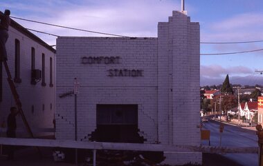 Stawell Historical Society Inc
Slide, Ian McCann, Comfort Station
Comfort Station now demolished Wimmera & main Street Street Stawellbuildings, comfort station -
 Bendigo Historical Society Inc.
Photograph - CASTLEMAINE GAS COMPANY COLLECTION: PHOTO HIGH STREET
High Street looking toward little View Street - Date UnknownPolaroidorganisation, industry, gas and fuel -
 Stawell Historical Society Inc
Memorabilia - Realia, c1870
Kerosene Street Lamp from Patrick Street. Used c1870 to 1900stawell -
Canterbury History Group
Photograph - Street view of 3 shops in Bryson Street, Canterbury, Stuart Warmington, 1995
Coloured photograph of street view of 3 shops in Bryson Street, Canterburycanterbury, maling road, shops, bryson street -
Canterbury History Group
Photograph - Street view of 3 shops in Bryson Street, Canterbury, Stuart Warmington, 1995
Coloured photograph of street view of 3 shops in Bryson Street, Canterburycanterbury, maling road, shops, bryson street -
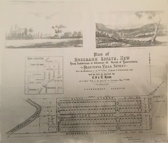 Kew Historical Society Inc
Print - Subdivision Plan, Rosebank Estate, Kew, Nineteenth Century
This work forms part of the collection assembled by the historian Dorothy Rogers, that was donated to the Kew Historical Society by her son John Rogers in 2015. The manuscripts, photographs, maps, and documents were sourced by her from both family and local collections or produced as references for her print publications. Many were directly used by Rogers in writing ‘Lovely Old Homes of Kew’ (1961) and 'A History of Kew' (1973), or the numerous articles on local history that she produced for suburban newspapers. Most of the photographs in the collection include detailed annotations in her hand. The Rogers Collection provides a comprehensive insight into the working habits of a historian in the 1960s and 1970s. Together it forms the largest privately-donated collection within the archives of the Kew Historical Society.A photographic reproduction of a plan in the Vale Collection of the State Library of Victoria. The plan shows the Rosebank Estate in Kew which was offered for sale in 1881. The subdivision was located in Studley Park and included lots in Redmond Street; Fellows Street; Wills Street; Molesworth Street; Barry Street and Princess Street. The surveyor of the subdivision was the local architect George Wharton.rosebank estate (kew), subdivisions -- studley park -- kew (vic.), thomas wills, wills family -
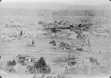 Stawell Historical Society Inc
Photograph, Panorama of Stawell from Big Hill 1878, North Scotchmans No6 and No7 and South Cross Mine whims and Poppet Heads
Scene from Big Hill. Shows Stawell looking to West c 1878 Patrick Streets and Sloane Street intersection. Back of Royal Exchange Hotel Kays Foundry in Wimmera Street. Coffee Palace formerly Castlemaine Hotel at right of photo. Mining poppet heads in foreground Three Whims in the foreground are North Scotchmans No 6 & 7 and South Cross in CentreSepia toned print & also a Black & White print (these photos are similar to 29.9). Photos show Western view of mining activity in Stawell c 1878. Kays Foundry on upper left and Upper Main Street on very right of photo.Stawell 1878 in Victoria.stawell, mining, panorama, streatscape -
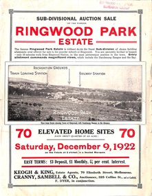 Ringwood and District Historical Society
Flyer, Sub-divisional auction sale advertisement - Ringwood Park Estate, Ringwood, Vic. - 1922
Folded double-sided page with black and white photographs of local views with black and red print advertising auction sale on Saturday 9th December, 1922, - 70 residential home sites, including terms of sale, locality map, and description of local facilities and services. Subdivision includes Wonga Road (later Loughnan Road), William Street, Andrew Street, and Harrison Street. Vendors Solicitors - Rigby & Fielding, 60 Market Street, Melbourne. Estate Agents - Keogh & King, 70 Elizabeth Street, Melbourne, Telephone 6938. Auctioneer - Cranny, Sambell & Co., 325 Collins Street, Melbourne, Telephone Central 5067 and 5077. -
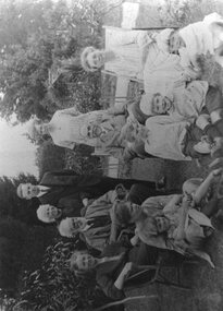 Surrey Hills Historical Society Collection
Photograph, John Inglis Lothian and family
John Inglis Lothian and family at 'Tantallon', c1925. John Inglis Lothian was born in Dunbar Scotland in 1851. He married Lillias Charlotte Smith (b 1847) in 1876. They had 6 children, all but the last born in Scotland before they migrated to Australia in 1888. Children were: 1. Margaret Morrison (1879 - ) 2. Thomas Carlyle (1880 - 1974) 3. Elizabeth Inglis (1882 - 1973) 4. Lillias Smith (1883 - 1971) 5. Isabella Margaret (1885 - 1946) 6. John George (1892 - 1983). Lillias Smith Lothian (Father's name: Morrison Smith; Mother's name Margaret Inglis) died in Ringwood and is buried in Box Hill Cemetery (C-*-0138). Most of the other members of the family were cremated and their ashes scattered. The family were in York Street, Surrey Hills in 1903 but moved to Ringwood where they were orchardists, returning to 59 York Street by 1927, by which time John Inglis Lothian had retired. Thomas Carlyle Lothian lived at 33 York Street (St Abbs) and established Lothian Publishing Co Pty Ltd. He died on 19 Apr 1974 in Mont Albert. A black and white photograph of a family group of 8 adults and four children in a garden setting; some being seated in chairs and deck chairs, some seated on the grass and some standing.lothian publishing company, 1900, 'tantallon', 'st abbs', house names, york street, surrey hills, john inglis lothian -
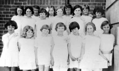 Surrey Hills Historical Society Collection
Photograph, Chatham State School Grade 2 1928, 1931
Chatham School, located in Weybridge Street Surrey Hills, was opened on 1 August 1927 following pressure from local residents as nearby schools (Balwyn, Mont Albert & Surrey Hills) were all over-crowded. This followed a surge in development following WW1. Land in surrounding streets was sub-divided. This included part of John Butler Maling (Jnr)'s small farm bounded by Banool Road, Wharton Road, Weybridge Street and Whitehorse Road. An area surrounding his home, 'The Willows' was retained and not sold until after he died in 1931. leased by Mr John Butler Maling in 1861. Three acres of his land were purchased by the Education Department. Some of the early students have referred to Chatham’s land as Mr Maling’s bull paddock. Some of the original yellow box trees remain on the property. The most significant of these is now called the Friendship Tree. On 1 August 1927 212 students were enrolled; Ralph Rae was one of these. The school was official opened on 15th February 1928. The school number is 4314. Front row centre is Jocelyn Cerini who married Ken Hall, another Chatham student. A black and white photograph of a group of Grade 2 female students from Chatham State School. They are dressed in white.schools, chatham state school, clothing and dress, primary schools, john butler maling (jnr), ralph rae (mr), jocelyn cerini (miss), jocelyn hall (mrs)