Showing 12766 items
matching reserves
-
 Greensborough Historical Society
Photograph - Digital Image, Pioneer Reserve 2014 -6, 23/09/2014
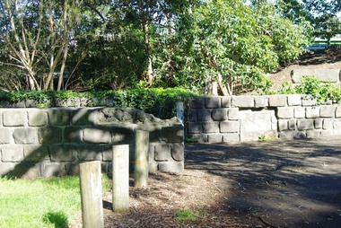
Pioneer Reserve, Greensborough is a small park on the corner of St Helena and Diamond Creek Roads. It is adjacent to the site of Greensborough's first bridge across the Plenty River, c. 1864 - 1960s. The shelter, viewing platform, retaining wall and entrance are built from the bridge's massive bluestone arched abutments dismantled between 1974 and 1983. Photograph by Marilyn Smith 2014.Digital copy of colour photograph.pioneer reserve greensborough -
 Greensborough Historical Society
Photograph - Digital Image, Pioneer Reserve 2014, 23/09/2014
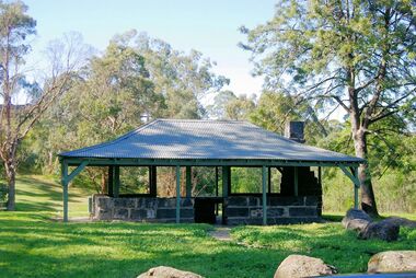
Pioneer Reserve, Greensborough is a small park on the corner of St Helena and Diamond Creek Roads. It is adjacent to the site of Greensborough's first bridge across the Plenty River, c. 1864 - 1960s. The shelter, viewing platform, retaining wall and entrance are built from the bridge's massive bluestone arched abutments dismantled between 1974 and 1983. Photograph by Marilyn Smith 2014.Digital copy of colour photograph.pioneer reserve greensborough -
 Greensborough Historical Society
Photograph - Digital Image, Pioneer Reserve 2014 -8, 23/09/2014
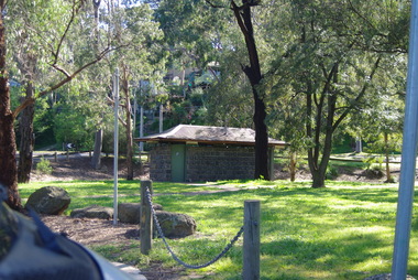
Pioneer Reserve, Greensborough is a small park on the corner of St Helena and Diamond Creek Roads. It is adjacent to the site of Greensborough's first bridge across the Plenty River, c. 1864 - 1960s. The shelter, viewing platform, retaining wall and entrance are built from the bridge's massive bluestone arched abutments dismantled between 1974 and 1983. Photograph by Marilyn Smith 2014.Digital copy of colour photograph.pioneer reserve greensborough -
 Uniting Church Archives - Synod of Victoria
Commemorartive Key, c1937
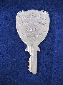
This new church built on 6 Clarkmount Road Sassafras was opened on 30th January, 1937 by Moderator Right-Rev. A Irving Davidson, M.A. It replaced the Log Cabin Presbyterian Church which erected in 1925 as a memorial to G H Derry, the first Chairman of the Recreation Reserve. The new church was built with donations from Mr and Mrs Thomas Kennon.Silver commemorative key with dedication engraved on both sides."THOMAS KENNON MEMORIAL CHURCH OPENED 30th January 1937" "Presented by Scarborough, Robertson & Love to MRS KENNON"thomas kennon memorial church, sassafras -
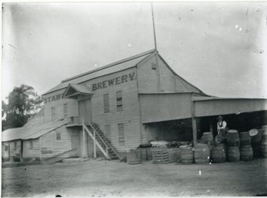 Stawell Historical Society Inc
Photograph, Brewery Building of the Stawell Brewery originally owned by Thomas Powell and later Bryant and Co in Stawell West near the Botanical Reserve
Wooden Brewery Building Stawell Brewery originally owned by Thomas Powell and later Bryant and Co. Located Stawell West near the Botanical Reserve. Closed about 1918. where there are scores of Hotels common sense says "Build a Brewery" and share the takings. Stawell Brewery was situated in part of the present Caravan Park. Almost opposite the entrance to the RacecourseTwo Story wooden Building with additions to left. A Man sitting on Barrels to the right.Stawell Breweerystawell, stawell brewery -
 Ballarat Heritage Services
Film - Video, Clare Gervasoni, Lal Lal Waterfall, 15/10/2022
Lal Lal Waterfall is situated in the Lal Lal Reserve. It has an impressive drop into a rocky gorge. Culturally, the Falls are believed to be the earthly home of Bunjil, the All Father or Creator to most Victorian Aboriginal tribes. The name Lal Lal is thought to be Aboriginal for "dashing of waters". The Lal Lal Falls is listed on the Site Registry of Aboriginal Affairs Victoria as a spiritual place.Video of the Lal Lal Waterfall after heavy rain.lal lal, lal lal waterfall -
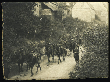 Magnet Galleries Melbourne Inc
British Lancers in France, dargo-098.tif
A group of British lancers moving through a village in France in 1917. For much of the war the British High Command kept immense reserves of cavalry behind the front line in the belief they could exploit successful thrusts by infantry into enemy lines. Pitted against the heavy artillery and the elaborately fortified trenches that typified the First World War, horses proved next to useless. On the back of the photograph its says "British Lancers in France"british, lancers, france, 1917, ww1, world war 1, war, horse, soldiers -
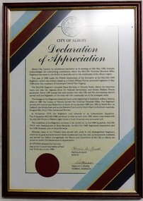 8th/13th Victorian Mounted Rifles Regimental Collection
Document - Freedom of City, 1998
Presented to the 8th/13th Victorian Mounted Rifles Regimental Association at a Reserve Forces Day parade in Civic Square Albury by the mayor, Councillor Patricia Gould, July 1998. The parade was followed by a march along Dean Street. Albury had proposed to confer Freedom of the City on the regiment, but Army protocol would not allow this, to the great disappointment of both parties.Framed City of Albury Declaration of Appreciation Certificate coloured white & cream with City seal and 8/13th Victorian Mounted Rifles Regiment Stable belt colours.freedom, appreciation, albury, council, vmr -
 Beechworth RSL Sub-Branch
Lanyard, Battle Dress, Australian Government Clothing Factory, 1981
This lanyard attaches under the right shoulder epoulette of a jacket issued as a Royal Australian Engineers uniform item post WWII until the late 1980s. It was also used parade dress until its replacement of a newly designed uniform made of polyester. This particular sample belonged to CPL K. Howe 3144504 whist in the Army Reserves 1982 to 2005The khaki battledress was a standard uniform issued post world war two and used until the introduction of the polyester uniform in the late 1980s. This lanyard is a component of a uniform belonging to CPL K. Howe, the donor provided good provenance, in conjunction with other items of militaria donated by the Howe family. The Uniform can tell a story of multi generations of military service of the Howe familyA length of thick, navy blue, cylindrically shaped fabric. Knotted in two locations to create two loops at either end. One loop is 270mm long when outstretched and the other is 82mm long when outstretched.royal engineers, battledress jacket, battledress jacket khaki, lanyard, royal australian engineers -
 The Beechworth Burke Museum Research Collection
Card (Series) - Index Card, George Tibbits, Ford Street, Beechworth, 1976
George Tibbits, University of Melbourne. Faculty of Architecture, Building and Town & Regional PlanningIndex system that support the research for Beechworth : historical reconstruction / [by] George Tibbits ... [et al]Arranged by street names of BeechworthEach index card includes: street name and number of property, image of property, allotment and section number, property owners and dates of ownership, description of the property according to rate records, property floor plan with dimensions.beechworth, george tibbitsbeechworth, george tibbits -
 Orbost & District Historical Society
Book - front cover, The Corringle Creek to Sydenham Inlet Coastal Reserve A RESOURCES STUDY, 1977
This 1977 Resources Study was a joint project of the Shire of Orbost & the Dept. of Crown Lands & Survey with the purpose of collating information on natural resources, pattern of public use, and constraints on future use so that management can be formulated.This report gives and understanding of the resources and management directions of coastal land in East Gippsland in 1977. A buff coloured cover with black printing and blue tape binding. 71 pages + maps/charts. THE CORRINGLE CREEK TO SYDENHAM INLET COASTAL RESERVE. A resources study with comment on the implications for management by IAN R. BROWN Research officer and PETER B. LAVERY Land Management Oficer. Coastal management Committee Victoria 1977. Published under the authority of the Coastal Management Committee by the Department of Crown Lands and Survey, Victoria 1977. Printed by James Yeates Printing, Bairnsdale 3875.corringle creek, sydenham inlet, natural resources survey -
 Ringwood and District Historical Society
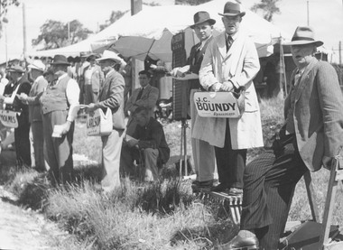
Photograph, Jamboree Athletic Meeting held at Ringwood, 8th January 1949
Catalogue card reads, "Jamboree Athletic Meeting held at Ringwood, 8th January 1949. The carnival was historic in that for the first time in the annals of Ringwood, a liquor booth operated at the grounds and bookmakers laid the odds". An addition note on the back of the photograph reads, "The Bookies and the Booth. The bookmakers are apparently a law unto themselves. The Council had refused permission for the bookmakers to operate on the reserve, but here they are." -
 Ringwood and District Historical Society
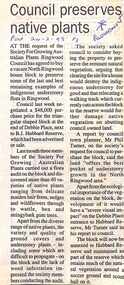
Newspaper, Scrapbook Clipping, Library Collection, Ringwood, Victoria, `
``Newspaper clipping from "The Post", 24-2-93, P 3. Council preserves native plants At the request of the Society For Growing Australian Plants, Ringwood Council has agreed to buy a vacant house block to preserve some of the last and best remaining examples of indigenous understorey flora in Ringwood. Council last week negotiated a $48,000 purchase price for the triangular shaped block at the end of Debbie Place, next to B.J. Hubbard Reserve, which had been advertised for sale. ` -
 Ringwood and District Historical Society
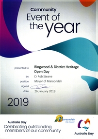
Certificates and Booklet, Maroondah City Council Award to Ringwood Historical Society 26 January 2019 - Community Event of the Year - 60th Birthday Open Day
This award is in recognition for the Society's 60th Birthday Open Day ExhibitionRDHS was nominated for an award for our Ringwood and District Heritage Open Day, held on 27 October 2018. The Society was announced as the winner at the Maroondah City Council Australia Day Awards Ceremony held at Ringwood Lake Reserve on 26th January 2019. It was accepted by RDHS President Russ Haines. This catalogue item consists of - Maroondah City Council Australia Day Awards & Australian Citizenship Ceremony Booklet - Nomination Certificate - Winning award Certificate - Maroondah Council Official Photograph of Russ Haines with Certificate (See Item 11001 for photographs of the presentation ceremony) -
Frankston RSL Sub Branch
Souvenir Tablecloth, 1915 (estimated)
Gold coloured silk tablecloth with green braid edging and mauve silk fringing. It is heavily embroidered with various flags, crowns and flowers relating to the Gallipoli campaign. Possibly made in Eygpt. The flags featured are Australia, France, United Kingdom, Egypt, Japan, Italy, Belgium and Russia. Some fraying along folds. The RAN Bridging Train (RANBT) was a naval reserves unit trained to provided engineering support such as assembling pontoons, temporary jetties and unloading stores. The 1st RANBT supported the British landing at Suvla Bay (north of ANZAC Cove) on the 7th of August 1915.In the centre of the tablecloth, embroidered in blue silk thread, are the following words "Suvla Bay 1915 6th October 1st RANBT" (Royal Australian Navy Bridging Train)gallipoli, trench, art, souvenir, embroidered, silk, flags, tablecloth, campaign, cloth -
 Ringwood and District Historical Society
Photographs, 1979-80 MMBW pipe line project at Hubbard Reserve, North Ringwood � Back-hoe at pit
E560 N6 Dec 1979 A43 The back-hoe works on the beginnings of pit in 39 Burlock Avenue backyard Part of a 43-photo record of the MMBW�s engineering feat in drilling a 12 inch pipe line up to 40 feet deep through rock hardened by volcanic action associated with geological fault that occurs along the line. The work took place from October 1979 to May 1980 on the southern boundary of Hubbard Reserve, North Ringwood. The collection was presented to the Ringwood Historical Research Group by J Clarke on 9th June 1980. -
 Federation University Historical Collection
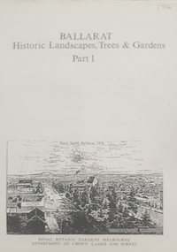
Book, Peter Lumley et al, Ballarat: Historic Landscapes, Trees & Gardens, 1983
Lisa Green and Lisa Morcom of Ballarat College of Advanced Educatiion contributed to this report.275 page landscape study of Ballarat including Trees in the Victorian Landscape; Plant sources early Ballarat nurseries, Botanical Gardens, Lake Wendouree, Fairy Gardens, Victoria Park, Ballaarat Old Cemetery, Eastern Oval, City Oval, Ballarat East Town Hall Gardens, Eureka Stockade, Observatory, Yarrowee, Black Hill, Sovereign Hill, Cheek Channels, Canadian Creek, Poverty Point Reserve, Goldmining Relics, Woah Hawp, Buninyong, street plantings, Russell, Victoria, Bridge Mall, Sturt Street Gardens, Avenue of Honour, Webster, Elms, ballarat, trees, nursery, r.u. nicholls, francis moss, ballarat botanical gardens, victoria park, lake wendouree, ballaarat old cemetery, eastern oval, ballarat east town hall gardens, ballarat school of mines botanical gardens, eureka stckade recreation reserve, ballarat observatory, yarrowee creek, black hill reserve, sovereign hill, ballarat avenue of honour, victoria street plantings, bridge mall plantings, george longley -
 Federation University Historical Collection
Plan, Underground Survey of Mines, Ballarat East, 1885, 09/1889
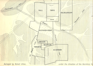
Surveyed by Robert Allan under the direction of the Secretary of Mines.Rectangular plan showing placement of mines in 1889. Mines include Hick's and Gilpin's lease, Comstock, Melbourne Company, Victoria United, Speedwell Company, New Normanby, Pasha Surprise, Central Sulieman, West Llanberris, Britannia United, Victoria Unites, Clinton's, Orient Company, North Sulieman, Sulieman Extended, Pasha Surprise, Golden Fountain, Prince regent, Clark and Company, Tinworth, North Woah Hawp, Detering, R.A. Thompson, Dazelles and buchanan, Barnett, Braybrook, Ladt Cornwall, Hanthorne, Dalzelles and gay, Southern Cross, M. Acheson, Cricket Reserveballarat east, mines, mining, underground survey, robert allan, chinese, ah chong, ah young, bakery hill, black hill, black hill lead, bakery hill lead, cricket, pennyweight hill, gravel pitts lead, golden point lead, navy jack's lead, mopoke lead, eureka lead, association lead, warrenheip lead, cgt, plans -
 Bendigo Historical Society Inc.
Document - HANDWRITTEN PAPER ''THE WESLEYANS'': AUTHOR: BEV O'SHEA
Handwritten 11 paged Paper on ''The Wesleyans'' - author: Bev O'Shea submitted for 'Australian History' (where??); date? With specific reference to the Bendigo area including ref to - James Jeffrey; Sir John Quick; Laurel Street church history; schooling and education; School No 279 Golden Square; Wesleyan Chapel Reserve; School No 1189 Golden Square; Table of various church denominations with their number of churches, buildings, accommodation and number usually attending (no date provided); post-1873 Education Act; 'rules' of living for Methodists; current situation. Bibliography.Bev O'Sheachurch, history, golden square wesleyan, methodist. laurel street. sir john quick. james jeffrey. bev o'shea. golden square wesleyan church. -
 Bendigo Historical Society Inc.
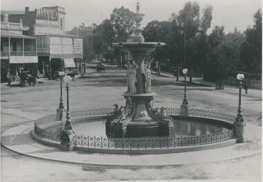
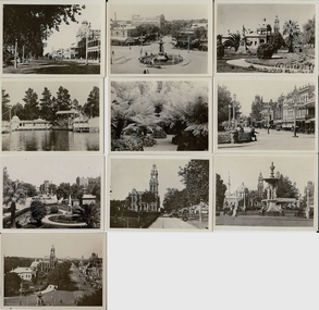
Photograph - ALEXANDRA FOUNTAIN AT CHARING CROSS, 1888
Black and white photograph showing view of fountain at Charing Cross. Shopfronts (Bissets, Mannings), two hansoms at View Point. Cart proceeding north on View Street. Two pedestrians on footpath by the Camp Reserve. On back - stamped in circle - 'Royal Historical Society of Victoria, Bendigo Branch'. In black ink - 'MP260'. In image on buildings 'Geo. S. Bissett, Importer of Drapery, Clothing and Millinery', 'Manning & .. , Drapers & Tailors'. History of object: previous Acc. No. 'MP 260'. Ian Wild, June 2000 'Bendigo Fountain before tramline went to Eaglehawk - prior to 1888'.place, streetscape, alexandra fountain -
 Bendigo Historical Society Inc.
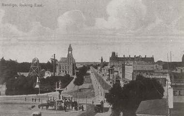
Photograph - BENDIGO LOOKING EAST ALONG PALL MALL, c1915
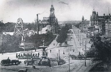
Black and white photograph taken from the City Family Hotel Tower, looking along Pall Mall towards White Hills, Showing Alexandra fountain, toast rack tram, 1903 tram, Hustler's Royal Reserve Mine, Post Office, Law Courts behind, tram track, School of Mines tower, Shamrock Hotel and other businesses, The Beehive, Pikes Building and verandah of building in foreground. Inscriptions: 'Bendigo, looking East' in TLH corner. History: photographic copy in black and white of a colour tinted postcard, printed c1915. Copied c1970place, streetscape, pall mall, photograph, photography, bendigo, alexandra fountain, toast rack tram, bendigo law courts, bendigo post office, bendigo school of mines, beehive building, hustler's royal reserve mine -
 Bendigo Historical Society Inc.
Photograph - BEAUTY SPOTS VICTORIA
black and white photos: small grey envelope containing black and white photographs of beauty spots in Victoria. Envelope contains photos of Bendigo. Produced in Australia by 'The Rose' Stereograph Co. Printers and Photographic publishers, Armadale, Victoria. (a) Pall Mall and the PO. Bendigo, (b) Queens Gardens, Bendigo ©Pall Mall and the P.O. Bendigo. (d) Alexandra Fountain, Bendigo. (e) The Upper Reserve, Bendigo (f) The Fernery, Bendigo (g) Pall Mall, Bendigo (h) Pall, Mall Bendigo (I) Alexandra Fountain, Bendigo (j) Queens Gardens, Bendigo.place, bendigo -
 Bendigo Historical Society Inc.
Postcard - CHARING CROSS, VALENTINE POSTCARD, ~1910
B+W photo of Charing cross from a 'Valentine' postcard photograph c1910 (details J. Lerk) streetscape from elevated position looking from Charing Cross down Pall Mall towards White Hills. Depicts: Alexandra fountain; electric tram; horse drawn wagon, dray, vehicles; Hustlers Royal reserve No2 mine, poppet heads, chimney; post office; tram power poles; buildings fronting Pall Mall; Pedestrians; trees; Queen Victoria statue; Colonial bank. Inscription: Lower right '53464 JV'.place, bendigo, view over alexandra fountain -
Bendigo Historical Society Inc.
Map - HUSTLER'S ROYAL RESERVE NO 2 CO - TRANSVERSE SECTION OF THE HUSTLER'S ROYAL RESERVE NO 2 CO
Transverse Section of the Hustler's Royal Reserve No 2 Co Mine on the Hustler's Line of Reef Bendigo, Bulletin No 33, Plate No VII. Section shows the poppet legs and the sill of Shaft at 707.65 ft above sea level, depth of levels, stone encountered and geological features. Geological Survey of Victoria emblem. H. Herman Director, W. Dickson Secretary of Mines and The Hon. J. Drysdale Brown MLC, Minister of Mines. Signed by H S Whitelaw, Underground Survey Office Bendigo, September 1913. This item has not been scanned or photographed.mining, parish map, hustler's royal reserve no 2 co, transverse section of the hustler's royal reserve no 2 co, h s whitelaw, undergrou;nd survey office bendigo, geological survey of victoria, h herman, w dickson, the hon. j drysdale brown mlc -
Bendigo Historical Society Inc.
Map - HUSTLER'S ROYAL RESERVE NO 2 (PARK SHAFT.) - TRANSVERSE SECTION OF THE HUSTLER'S ROYAL RESERVE NO 2
Transverse section of the Hustler's Royal Reserve, No 2 (Park Shaft.) on the Hustler's Line of Reef. Bulletin No 33, Plate No IX. Section shows poppet legs and sill of shaft at 755.70 ft above sea level, depth of levels, type of stone encountered including lava and geological features. Geological Survey of Victoria emblem and beneath it H. Herman, Director, W. Dickson, Secretary of Mines and The Hon. J. Drysdale Brown MLC Minister of Mines and signed by H S Whitelaw, Underground Survey Office, Bendigo September, 1913.mining, parish map, hustler's royal reserve no 2 (park shaft.), transverse section of the hustler's royal reserve no 2 (park shaft.), h s whitelaw, underground survey office bendigo, geological survey of victoria, h herman, w dickson, the hon j drysdale brown mlc, hustler's line of reef -
 Bendigo Historical Society Inc.
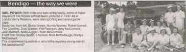
Newspaper - JENNY FOLEY COLLECTION: GIRL POWER
Bendigo Advertiser "The way we were" from Tuesday, May 11, 2004. Girl power: with mitts and bats at the ready, some of these players of the Royals softball team, pictured in 1947-1948 at Londonderry Reserve, were also sporting very avant garde caps. Back row from left: Biddy Brown, Normie Warner, Robin Burnett, Fay Cowling, Dosi Warner, Pat Paterson, Amy McCormick, Jean Burnett, Addi Duggan, Ruth McCormick. Front row: Shirley Smith, Effie Bell, Nola McCullaugh, Gladys McCormick.newspaper, bendigo advertiser, the way we were -
 Bendigo Historical Society Inc.
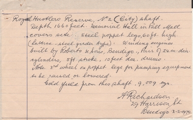
Document - ALBERT RICHARDSON COLLECTION: HANDWRITTEN LETTER ROYAL HUSTLERS RESERVE
Hand written letter signed by A. Richardson, 29 harrison street, Bendigo - 03/02/1970. Royal Hustler Reserve No. 2 (lift) shaft. Depth 1660 feet. Memorial Hall in Pall Mall covers site. Steel poppet legs, 60 ft high (lattice-steel garden type). Winding engines built by Roberts and Sons, Bendigo. Pair of 24 in. clear cylinders, 5ft stroke, 10ft ? drums. Note 3rd wheel on poppet legs for pumping equipment to be raised or lowered. Gold yield from this shaft 9,009 ounces.person, mining, albert richardson -
 Ballarat Tramway Museum
Photograph - Colour Print/s - set of 5, Carolyn Dean, 1/10/1995 12:00:00 AM
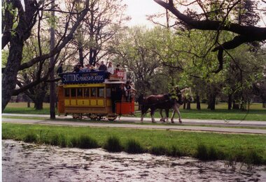
Yields information about the operation of the horse tram in Wendouree Parade and some of the people involved and the way it was operated.Set of five colour photographs taken by Carolyn Dean on 1 October 1995 during operations of the Horse Tram No. 1 in Wendouree Parade Printed on Fujicolor paper. .1 - Horse tram, northbound, North Gardens Reserve from the lake side .2 - approaching loop .3 - Richard Gilbert, Merv Mitchell, Mrs Mitchell, George Netherway and ? at the Gardens loop with the tram stop in the background. .4 - Leaving loop with 27 in far background .5 - as for .1, but southbound. Carol See also Reg Item 2126.1 > 2126.8 for other photos of the same event. On rear of each photo in blue ink "1.10.95"horse trams, wendouree parade, gardens loop, tram 1 -
 Ballarat Tramway Museum
Photograph - Black & White Photograph/s, c1900
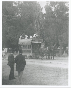
Yields information about the seven window horse tram - copy photographic print of Reg Item 257.Black and white photograph of a 7 window horse tram in Gardens Reserve, reproduced from stereo pair, Reg. No. 257, from a copy negative. Copy made Oct. 2001 for the "gold, Gold GOLD" temporary exhibition - colour laser print onto card, with Velcro dots on rear. Stored in box D1 (Display Box) 02/2003. 2nd copy of print added 29/7/2007 from Alan Bradley collection of photographs to depot 5/2007. High Res Images added 5/3/2011.trams, tramways, ballaarat tramway company, 7 window horse tram, gardens, horse trams -
 Kew Historical Society Inc
Plan - Subdivision Plan, Kew Golf Links Estate, 1936
The Kew Golf Links Estate was a major subdivision in North Kew. It derived its title due to the land being previously occupied by the Kew Golf Club, which transferred its course to a number of locations before occupying its current site. The Plan advertises 180 choice home sites. The street names are somewhat different today as those on the map are named after the proposed Kodak Factory to be built on the site. The subdivision of the Kew Golf Links Estate was a major subdivision of farmland in Kew. The site was at one stage designated for industrial development and the building of a new Kodak factory. The decision by Council to oppose the redevelopment makes the beginning of the period when all industrial development was banned in Kew.Monochrome printed, folded subdivision plan for the Kew Golf Links Estate, to be auctioned on 7 November 1936. Streets named include: Carnegie Avenue, Willsmere Road, Kilby Boulevarde, Kodak Avenue, Coleman Avenue, Beresford Avenue, McConchie Avenue, Cole Avenue, White Avenue, Baker Avenue, Spruzen Avenue, Tanner Avenue, Ratten Avenue, Mathers Avenue, Railway Avenue, Sutherland Avenue, and Belford Road. The position of the Yarra River and a large Drainage Reserve are marked on the plan. Lots for sale are numbered. Existing buildings are designated with a square.subdivision plans - kew (vic), kodak factory - kew (vic)