Showing 2343 items
matching flying
-
 Rutherglen Historical Society
Image, Kingsway Real Photos, c1910
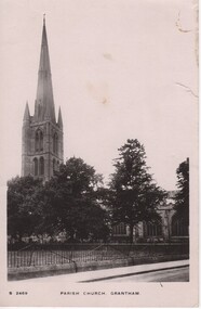
Found at the rubbish tip. Postcard written by Percy Fullerton during WWI to his future wife Fern Aitken.Black and white photograph on postcard, showing church with tall steeple.At bottom of photo: "S 2469 Parish Church, Grantham" On back of postcard: "22/10/17 | Darling Fern, Doing A.1. and hope to be out of Hospital by the end of the week. I had the pleasure of looking down on this church last week, think I told you in my last that I had been up flying. Trusting this finds my bonnie little girl well as it leaves yours lovingly. Percy xxxx"percy fullerton, fern aitken, world war 1, world war i, ww1, wwi -
 Eltham District Historical Society Inc
Photograph - Aerial Photograph, Landata, Research, Vic, Apr. 1963
Centred on present day Marconi Court, Research bounded by Maroondah Aqueduct to north, Thompson Crescent to south, Joselyn Drive to east and Eltham Research Oval to west. Historic Aerial Imagery Source: Landata.vic.gov.au Aerial Photo Details: Project No :486 Project : MELBOURNE (1963) PROJECT Run : 5 Frame : 62 Date : 04/1963 Film Type : B/W Camera : RC8 Flying Height : 5100 Scale : 9600 Film Number : 1805 GDA2020 : 37°42'24"S, 145°10'43"E MGA2020 : 339434, 5825157 (55) Melways : 22 F3 (ed. 42)aerial photo, neil webster collection, 1963-04, joselyn drive, marconi court, melway 22f3, research (vic.), research oval, thompson crescent -
 Eltham District Historical Society Inc
Photograph - Aerial Photograph, Landata, Research, Vic, Apr. 1972
Centred on present day Maroong Drive, Research bounded by Allendale Road to north, Thompson Crescent to south, Eltham College to east and Parsons Road to west. Historic Aerial Imagery Source: Landata.vic.gov.au Aerial Photo Details: Project No :985 Project : MELBOURNE 1972 Run : 26 Frame : 193 Date : 04/1972 Film Type : B/W Camera : RC10 Flying Height : 5700 Scale : 9600 Film Number : 2636 GDA2020 : 37°42'04"S, 145°10'33"E MGA2020 : 339187, 5825794 (55) Melways : 22 F1 (ed. 42)aerial photo, neil webster collection, 1972-04, allendale road, eltham, eltham barrel, eltham college, maroong drive, melway 22f1, parsons road, research (vic.), thompson crescent -
 Eltham District Historical Society Inc
Photograph - Aerial Photograph, Landata, Eltham, Vic, Apr. 1972
Centred on present day Ryans Road at Sandra Avenue, Eltham bounded by Progress Road to north, Brougham Street to south, Bible Street to east and Outlook Crescent to west. Historic Aerial Imagery Source: Landata.vic.gov.au Aerial Photo Details: Project No :985 Project : MELBOURNE 1972 Run : 27 Frame : 48 Date : 04/1972 Film Type : B/W Camera : RC10 Flying Height : 5700 Scale : 9600 Film Number : 2636 GDA2020 : 37°42'41"S, 145°08'38"E MGA2020 : 336392, 5824574 (55) Melways : 21 H4 (ed. 42)aerial photo, neil webster collection, 1972-04, eltham, bible street, brougham steet, melway 21h4, outlook crescent, progress road, ryans road, sandra avenue, montmorency -
 Eltham District Historical Society Inc
Photograph - Aerial Photograph, Landata, Montmorency, Vic, Apr. 1972
Centred on present day Olympic Avenue at Grand Boulevard, Montmorency bounded by Meruka Drive to north, Main Road to south, Main Road to east and Alban Street to west. Historic Aerial Imagery Source: Landata.vic.gov.au Aerial Photo Details: Project No :985 Project : MELBOURNE 1972 Run : 28 Frame : 206 Date : 04/1972 Film Type : B/W Camera : RC10 Flying Height : 5700 Scale : 9600 Film Number : 2635 GDA2020 : 37°43'21"S, 145°07'46"E MGA2020 : 335154, 5823329 (55) Melways : 21 E7 (ed. 42)aerial photo, neil webster collection, 1972-04, eltham, alban street, grand boulevard, lower plenty, main road, melway 21e7, meruka drive, montmorency, olympic avenue -
 Eltham District Historical Society Inc
Photograph - Aerial Photograph, Landata, Eltham, Vic, Apr. 1972
Centred on present day Mays Road at Stringybark Road, Eltham bounded by Nyora Road to north, Yarra River to south, Reynolds Road to east and Bible Street to west. Historic Aerial Imagery Source: Landata.vic.gov.au Aerial Photo Details: Project No :985 Project : MELBOURNE 1972 Run : 28 Frame : 209 Date : 04/1972 Film Type : B/W Camera : RC10 Flying Height : 5700 Scale : 9600 Film Number : 2635 GDA2020 : 37°43'33"S, 145°09'28"E MGA2020 : 337647, 5823013 (55) Melways : 22 B8 (ed. 42)aerial photo, neil webster collection, 1972-04, eltham, bible street, mays road, melway 22b8, nyora road, reynolds road, stringybark road, yarra river -
 Eltham District Historical Society Inc
Photograph - Aerial Photograph, Landata, Eltham, Main Road; Henry St to Bellevue Rd, Dec. 1945
Eltham, Main Road; Henry St to Bellevue Rd, and east along Luck St to present day Eltham East School Historic Aerial Imagery Source: Landata.vic.gov.au Aerial Photo Details: Project No :5 Project : MELBOURNE AND METROPOLITAN AREA PROJECT Run : 36 Frame : 60549 Date : 12/1945 Film Type : B/W Camera : EAG4 Flying Height : 10200 Scale : 6000 Film Number : 228 GDA2020 : 37°42'45"S, 145°08'59"E MGA2020 : 336903, 5824465 (55) Melways : 21 K4 (ed. 42)aerial photo, arthur street, bellevue road, bible street, diamond street, dudley street, elsa court, eltham, eltham east primary school, gahan house, henry street, livingstone road, luck street, main road, pryor street, neil webster collection -
 Eltham District Historical Society Inc
Document - Folder, Oyston, Peter
Peter Oyston died in 2011. His career included being Founding Dean of drama at the Victorian College the Arts and director of Playbox Theatre. He was a champion of theatre companies including The Murray River Performing Group, The Flying Fruit Fly Circus, West Theatre and Theatreworks. He taught at the Royal Academy of Dramatic Art in London and directed more than 200 productions in Australia and other countries. He had one daughter. Contents Newspaper article: "Director takes his curtain call", Diamond Valley Leader, 19 October 2011, Obituary of Peter Oyston.Newspaper clippings, A4 photocopies, etcpeter oyston, victorian college of the arts, bend of islands, playbox theatre, the fying fruit fly circus, theatreworks, royal academy of dramatic arts london, dominque oyston, ray mooney, west theatre, the murray river performing group -
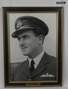
 Bendigo Military Museum
Photograph - PHOTOGRAPH WW1, FRAMED, Post 2000
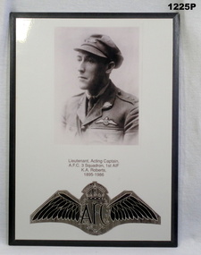
Kenneth Arthur ROBERTS No 4582 enlisted in the AIF in 14th reinforcements 5th Battalion on 6.7.1915 age 21 years 8 months. Embarked for Egypt 28.1.1916, transfers to 57th Bn 20.3.1916, embark for France 18.6.1916, transfers to Aust Flying Corps (AFC) 30.11.1916, promoted 2nd Lt 25.3.1917, hospital with Scabies 27.8.1917, rejoin unit 27.8.1917, to be Lt from 23.8.1917, embark for France 10.9.1917, hospital 25.11.1917 with Nasal obstruction, rejoin unit 29.12.1917, hospital 13.1.1918 Sprained right knee and ankle severe, classed as WIA, rejoin unit 3.7.1918, discharged from the AIF 5.10.1919. B&W photo showing LT KA Roberts in uniform. Under the photo are his details, under that is the AFC emblem. Photo is on a white paper sheet on particle board with black frame.military history, photography-photographs, frame accessories, afc -
 Mission to Seafarers Victoria
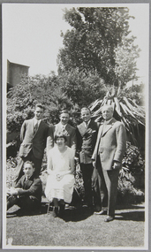
Photograph - Photograph, Black and white, Mrs Weller, A Sunday lunch group in the Chaplaincy garden, Dec. 1925, December 1925
Dora Walker (married 1928 taking the name Simpson) had a long association with the Mission as a member of the Ladies Harbour light guild. This image is similar to another image in the collection which depicts the garden of the Walker family where many fund-raising events and hosting of seafarers took place. Rev Weller dates the image to around mid to late 1920s. In the 1960s and 70s Dora was president of the LHLG which later merged with the Flying Angels. She was awarded the MBE for her services to the community in the 1970s. Dora's son David Simpson is a volunteer still iat MTS n the 21stC. The Walker and Simpson families are examples of long association and commitment supporting the Mission to Seafarers. As they are researched it is clear the stories of these families document not only support for the Mission but are also shown to have been significant contributors, leaders and donors to the broader Melbourne and Victorian community from the 19th Century and up to the present day. The photograph shows the garden in its early years.Group portrait depicting 4 men in suits standing (reverend Weller on the right), a man sitting on the grass, next to a woman in white summer dress (Dora Walker), sitting on a chair in front of the men. They are photographed outdoor probably in the mission's garden (in the background we can see the letters E-EX on a building wall, thought to be from the Extension Bond and Free Stores located next to the mission at the time)dora walker, reverend reginald weller, picnic, cadets, officers, lhlg, amy dora walker, dora simpson, mission's garden, flinders street, mission to seafarers, seamen's mission, mission to seamen, ladies harbour lights guild, melbourne, lawn, grass, trees, plants, peppercorn tree, weller album, dora simpson nee walker -
 Warrnambool and District Historical Society Inc.
Clothing, Warrnambool Urban Fire Brigade Belt, Mid 20th century
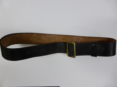
This belt was worn with the jacket issued to members of the Warrnambool Fire Brigade in the mid 20th century. The jacket was part of the uniform that served both as a dress uniform and a work uniform. The Warrnambool Fire Brigade was formed in 1863 following unsuccessful attempts to establish a permanent fire service in the town. It was prompted by a fire at the Flying Buck Hotel in Liebig Street. The Warrnambool Fire Brigade, now located on the Mortlake Road, has been successful in Victorian Fire Brigade competitions and demonstrations, particularly in the 19th century. The owner of the belt and uniform was John (Jack) Sizeland, a member of the Warrnambool Fire Brigade for over 37 years. This belt is of interest as it was part of a Warrnambool Fire Brigade uniform during the second half of the 20th century. It also has individual local provenance as it belonged to Jack Sizeland, a member of the Warrnambool Fire Brigade who retired in 1977 after 37 years of service. This is a brown leather belt with a gold metal buckle and nine punched holes on the buckle, two of them hand-punched. It has a leather attachment to keep the belt end in place. It has the name of the owner, John Sizeland, written in biro on the inside of the belt. This belt is meant to be worn with the Warrnambool Fire Brigade jacket with the brass buttons. ‘J. Sizeland, W’bool’warrnambool fire brigade, jack sizeland, history of warrnambool -
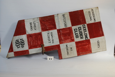 Australian Gliding Museum
Functional object - Rudder from Geelong Gliding Club Primary Glider, 1929
The Geelong Glider Club was formed in June 1929 at a meeting held at the Belmont Common hangar of Percy Pratt. The club built a Zogling (Primary Glider) based on plans obtained from Germany and flew it off nearby hills at Lovely Banks and other places in the Geelong region. The checked rudder design (without logo and markings) is evident in a picture of a Geelong Glider Club Zogling flying at Tower Hill near Warrambool, Victoria, at Easter 1931 and this lends support to the conclusion that the rudder was part of the Club’s first glider. The logo and markings appear to be a more recent elaboration to the design. Exhibit is a historical link to the earliest gliding activities of the Geelong Glider Club.Fabric covered wooden framed primary glider rudder with metal levers decorated with silver and dark red checkered design. The item has a cat logo on one side and markings on the other of places where the Geelong Gliding Club flew in its early years.On port side – Cat logo. On starboard side – Geelong Glider Club; and place names including Geelong Aerodrome, Batesford, Ceres, Lovely Banks, Tower Hill, Koroit, Mount Moriac; and years, 1929-1933 australian gliding, glider, zogling, primary glider, rudder, geelong gliding club, lovely banks, tower hill. koroit -
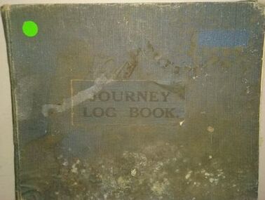 Moorabbin Air Museum
Journal (item) - Journey Log Book, DH Fox Moth VH-UQM Holyman Airways Pty Ltd
VH-UQM (Miss Currie) was the second commercial plane to operate out of Western Junction (after Miss Flinders), the first owned by the Holyman Brothers, which eventually become ANA etc. And we think it was one of the first planes destroyed in WW2, when it was lost in the hangar fire in Broken Hill just after war was declared. It was believed to have been sabotaged by Italian or German workers at Broken Hill at the time. It also was part of the early Flying Doctor service in NSW. Item currently held in Archives Australian National Aviation Museum (ANAM) September 2021 -
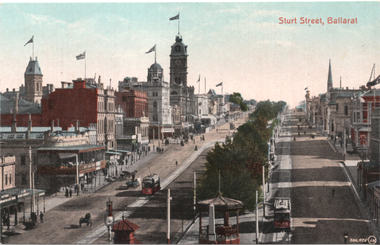 Ballarat Tramway Museum
Postcard, Valentine & Sons Publishing Co, "Sturt Street Ballarat:", c1912
Valentine Series postcard of Postcard, looking from the top of the Nichol and Allen Building in Grenville St looking west. Titled "Sturt St Ballarat" in the top left-hand corner. Has two ESCo trams in the view, with a 3rd outside the town hall. Shows all the buildings on both sides of Sturt St, many flying prominent flags. Postcard by Valentine & Sons, printed in Great Britain. In a note to Ken Magor, Wal Jack has written on the rear: "old type, No. 17 on left and No. 11 on right. Photo taken from Grenville Street looking west about 1912." Yields information about Sturt St looking west from Grenville St about 1912.Postcard, colour, divided back, with a handwritten note on rear.See image 2 for the handwritten note on the rear. tramways, trams, sturt st, postcards, grenville st, tram 17, tram 11, esco -
Moorabbin Air Museum
Machine - BE2A Wings, 1912
Historical Details: The AARG B.E.2a wings are a pair of upper main planes or wing panels without ailerons, of a wing warping design, and are almost certain to be sourced from the Central Flying School at Point Cook, as no other B.E.2a aircraft were ever brought to Australia. Description: The Royal Aircraft Factory in England was formed in 1911 and among its designers was Geoffrey de Havilland who later founded his own company. The B.E.2 was designed by Geoffrey de Havilland and first flew in February 1912 with de Havilland as the test. Level of Importance: National -
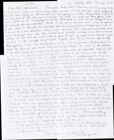 Wangaratta RSL Sub Branch
Letter
Letter dated 16/5/1945 from Pilot Neville Sparks to Mrs Wilkinson informing her of the possible death of her son when his plane was shot down. From collection of photographs and cuttings dedicated to the memory of WILKINSON JOHN HUDSON : Service Number - 400444 : Date of birth - 18 Feb 1914 : Place of birth - RUTHERGLEN VIC : Place of enlistment - MELBOURNE : Next of Kin - WILKINSON HUDSON. Wilkinson was awarded the distinguished flying cross in March 1944 and tragically killed in action over Germany also in 1944. See also 237 and 240. Photocopy of a handwritten letter. Single page.Rear - Mr Neville Sparks (John's pilot when they were shot down) wrote this beautiful letter to John and Hud's parents.pilot, kia, killed in action, dfc, distinguished flying cross, wwii, world war two, air force -
 Bendigo Military Museum
Photograph - PHOTOGRAPH RAAF, FRAMED, C. WW2
William Ellis NEWTON VC enlisted in the RAAF no 250748 on 5.2.1940 age 20 years 8 months. Serving with No 22Sqd RAAF flying Boston Bombers he arrived in New Guinea in May 1942. Along the way he was promoted to Pilot Officer, Flying Officer and then Flight Lieutenant. On the 18.3 1943 during a low level attack on Japanese positions around Salamaua he hit his target but his plane was hit several times by flack and burst into flames but he landed it in the sea. Sgt B.G Eastwood No 13055 a crew member went down with the aircraft. Newton and Flt Sgt J Lyon No 401706 swam to shore but were captured by the Japanese. Newton was taken to Lae for interrogation and then returned to Salamaua and was executed by decapitation and his body thrown in bomb crater on 29.3.1943. His body was later recovered in late 1943 when Australian troops captured Salamaua. Lyons was executed at Lae by bayoneting in the back. The award to Newton of the Victoria Cross was for low level attacks in the Salamaua area which inflicted heavy losses on Japanese installations one of which his plane was hit by flak heavily and he successfully flew it back some 180 miles and landed. The award also included the attack for which he was executed. Newtons and war crimes records are some 800 plus pages with photos, statements etc. Refer also Cat No 3456.Black & white photo, head & shoulders portrait of F/LT W. E. NEWTON V.C. He is wearing a peaked cap, collar & tie with RAAF wings badge on L side of jacket. In a green / gold wooden frame with glass front. Fawn paper backing. Gold plaque in middle beneath photo.Engraved on plaque: “F/LT W. E. NEWTON V.C. 22 Squadron RAAF”photograph, raaf, vc, newton -
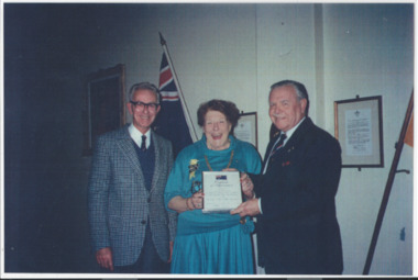 Melbourne Legacy
Photograph, The Australian National Flag Association, c1988
A photo of Mrs Billie Sims receiving a certificate. The blue paper label says: "Legacy Helping to keep the Aussie Flag Flying" President of the Australian National Flag Association of Victoria, Mr Ross Watson, O.A.M. (right) together with the Secretary of the Association, Mr Henry Farrell, thanked the ladies of Melbourne Legacy for their contribution to help keep the Aussie Flag Flying. Through the President of Melbourne Legacy Widows' Club, Mrs Billie Simms, Ross Watson presented a framed certificate to mark the splendid work of Melbourne Legacy Widows in attaching miniature Australian flags to thousands of sprigs of rosemary prepared for Anzac Day marchers and for the 2,000 plus school children who attend Legacy's annual Anzac Commemoration Ceremony at the Shrine of Remembrance." Similar to another certificate from the Australian National Flag Association given to the Melbourne Legacy Club in June 1984. It was with a group of photos from 1988 to 1990 in a folio with paper labels (see items 01042 to 01049). The explanation of the source of the rosemary was in the same folio but the described photo is missing. It says the rosemary donated to Legacy each year for the sprigs of rosemary handed out to the public comes from nurseryman, Peter Hannah, who sourced a cutting from a bush in Frankston which was said to come from a cutting brought home by a wounded soldier.A record of widows preparing rosemary as gifts for the public and the story behind the source of the rosemary. Rosemary is sign of remembrance.Colour photo of a widow receiving a certificate, a blue paper label and a yellow document explaining the source of the rosemary.Blue paper label explains the certificate in black type.widows, rosemary -
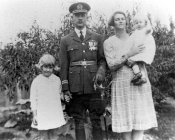 Surrey Hills Historical Society Collection
Photograph, William and May Palstra with Margaret and Jocelyn at 60 Guildford Road, Surrey Hills, 1920s, 1926
Date is approximate. William and May Palstra were married in 1920; 60 Guildford Road was their first and only home. William was with the university when he joined the Australian Flying Corps in WW1. He went back to university on his return from the war but in 1926 when the RAAF was formed he joined it as he had enjoyed flying. He took his family to England while he did 2 years training at the Imperial College in London under Air Vice-Marshall Jones. He was chosen as the Australian representative on a special flight of an experimental airship designed to fly over long distances. The test flight was destined for India, then on to Australia. Its passengers were high level British officials including the UK Secretary of State. It struck bad weather after crossing the Channel, clipped a hill and crashed in France. Some of the crew survived but William Palstra was killed. Mrs Palstra did not receive any compensation; only a small allowance, then cut during the Depression. She was given some support from the Returned Soldiers, Sailors and Airmen's association. Donor, Margaret Thornton was a daughter of William and May Palstra; one of her daughters, Julia Thornton still lives in the house in 2009. Donation form signed by Julia Thornton. Margaret and Jocelyn had a brother, also William. The house remains in 2009 with extensions to the rear and side.Black and white photo of William and May Palstra and 2 of their children in the garden of their home. William is in the uniform of the RAAF. He is holding Margaret's hand; Jocelyn is in her mother's arms.guildford road, raaf, australian flying corps, uniforms, william palstra, may palstra, margaret palstra, margaret thornton, jocelyn palstra, julia thornton -
 Eltham District Historical Society Inc
Photograph - Aerial Photograph, Landata, Eltham / Research, Vic, Jan. 1951
Centred on Brinkkotter Road opposite Yarramie Reserve, Eltham bounded by Maroondah Aqueduct to north, Nyora Road to south, Eltham College to east and Leane Drive to west. Historic Aerial Imagery Source: Landata.vic.gov.au Aerial Photo Details: Project No :65 Project : MELBOURNE AND METROPOLITAN PROJECT NO. 2 Run : 7 Frame : 8 Date : 01/1951 Film Type : B/W Camera : EAG9 Flying Height : 12200 Scale : 12000 Film Number : 1419 GDA2020 : 37°42'32"S, 145°10'41"E MGA2020 : 339408, 5824924 (55) Melways : 22 F3 (ed. 42)Historical aerial photos and photo maps provide viusal evidence of the chronology of changes to the built landscape of the district and assist in dating other imagesaerial photo, 1951-01, eltham, neil webster collection, brinkkotter road, eltham college, leane drive, maroondah aqueduct, melways 22f3, nyora road, yarramie reserve -
 Eltham District Historical Society Inc
Photograph - Aerial Photograph, Landata, Eltham, Vic, Jan. 1951
Centred on Beard Street between Main Road and Frank Street, Eltham bounded by Maroondah Aqueduct to north, Arthur Street to south, Maroong Drive to east and Catholic Ladies College to west. Historic Aerial Imagery Source: Landata.vic.gov.au Aerial Photo Details: Project No :65 Project : MELBOURNE AND METROPOLITAN PROJECT NO. 2 Run : 7 Frame : 9 Date : 01/1951 Film Type : B/W Camera : EAG9 Flying Height : 12200 Scale : 12000 Film Number : 1419 GDA2020 : 37°42'23"S, 145°09'39"E MGA2020 : 337874, 5825170 (55) Melways : 22 B3 (ed. 42)Historical aerial photos and photo maps provide viusal evidence of the chronology of changes to the built landscape of the district and assist in dating other imagesaerial photo, 1951-01, eltham, neil webster collection, arthur street, beard street, catholic ladies college, frank street, main road, maroondah aqueduct, maroong drive, melway 22b3, research (vic.) -
 Eltham District Historical Society Inc
Photograph - Aerial Photograph, Landata, Eltham North, Feb. 1956
Centred on present day 54 Kelway Crescent, Eltham North bounded by Glen Gully Road to north, Meruka Drive to south, Eltham College to east and Leach Street to west. Historic Aerial Imagery Source: Landata.vic.gov.au Aerial Photo Details: Project No :250 Project : MELBOURNE OUTER SUBURBS PROJECT Run : 17 Frame : 113 Date : 02/1956 Film Type : B/W Camera : EAG9 Flying Height : 10000 Scale : 12000 Film Number : 1176 GDA2020 : 37°42'16"S, 145°08'08"E MGA2020 : 335650, 5825336 (55) Melways : 21 G2 (ed. 42)aerial photo, 1956-02, eltham, eltham north, glen gully road, leach street, main road, melway 21g2, meruka drive, montmorency, neil webster collection -
 Eltham District Historical Society Inc
Photograph - Aerial Photograph, Landata, Montmorency, Feb. 1956
Centred on present day Tahlee Place Reserve and Sherbourne Preschool, Montmorency bounded by Progress Road to north, Withers Way to south, Main Road to east and Leach Street to west. Historic Aerial Imagery Source: Landata.vic.gov.au Aerial Photo Details: Project No :250 Project : MELBOURNE OUTER SUBURBS PROJECT Run : 17 Frame : 114 Date : 02/1956 Film Type : B/W Camera : EAG9 Flying Height : 10000 Scale : 12000 Film Number : 1176 GDA2020 : 37°42'50"S, 145°08'02"E MGA2020 : 335512, 5824286 (55) Melways : 21 F5 (ed. 42)aerial photo, 1956-02, neil webster collection, central park, eltham, leach street, main road, melway 21f5, montmorency, progress road, withers way, sherbourne preschool, tahlee place reserve -
 Eltham District Historical Society Inc
Photograph - Aerial Photograph, Landata, Lower Plenty, Feb. 1956
Centred on present day 217 Old Eltham Road, Lower Plenty bounded by Pitt Street to north, Yarra River to south, Main Road to east and Bonds Road to west. Historic Aerial Imagery Source: Landata.vic.gov.au Aerial Photo Details: Project No :250 Project : MELBOURNE OUTER SUBURBS PROJECT Run : 17 Frame : 116 Date : 02/1956 Film Type : B/W Camera : EAG9 Flying Height : 10000 Scale : 12000 Film Number : 1176 GDA2020 : 37°43'58"S, 145°07'49"E MGA2020 : 335237, 5822186 (55) Melways : 21 E10 (ed. 42)aerial photo, 1956-02, neil webster collection, eltham, main road, bonds road, elham, lower plenty, melway 21e10, pitt street, yarra river -
 Eltham District Historical Society Inc
Photograph - Aerial Photograph, Landata, Eltham, Feb. 1956
Centred on present day Shalbury Avenue, Eltham bounded by Leane Drive and Parsons Road to north, Nyora Road to south, Reynolds Road to east and the Diamond Creek to west Historic Aerial Imagery Source: Landata.vic.gov.au Aerial Photo Details: Project No :250 Project : MELBOURNE OUTER SUBURBS PROJECT Run : 18 Frame : 95 Date : 02/1956 Film Type : B/W Camera : EAG9 Flying Height : 10000 Scale : 12000 Film Number : 1176 GDA2020 : 37°41'57"S, 145°09'51"E MGA2020 : 338145, 5825965 (55) Melways : 22 C1 (ed. 42)aerial photo, 1956-02, neil webster collection, eltham, diamond creek (creek), melway 22c1, nyora road, parsons road, reynolds road, shalbury avenue -
 Eltham District Historical Society Inc
Photograph - Aerial Photograph, Landata, Research, Vic, Feb. 1956
Centred on present day Thompson Crescent, Research bounded by Maroondah Aqueduct to north, Thompson Crescent and Nyora Road to south, Bells Hill Road to east and Eucalyptus Road to west Historic Aerial Imagery Source: Landata.vic.gov.au Aerial Photo Details: Project No :250 Project : MELBOURNE OUTER SUBURBS PROJECT Run : 19 Frame : 6 Date : 02/1956 Film Type : B/W Camera : EAG9 Flying Height : 10000 Scale : 12000 Film Number : 1176 GDA2020 : 37°42'38"S, 145°11'02"E MGA2020 : 339927, 5824736 (55) Melways : 22 H4 (ed. 42)aerial photo, 1956-02, neil webster collection, bells hill road, eltham, eucalyptus road, maroondah aqueduct, melway 22h4, nyora road, research (vic.), thompson crescent -
 Eltham District Historical Society Inc
Photograph - Aerial Photograph, Landata, Research, Vic, Apr. 1963
Centred on present day Thompson Crescent and Nicholson Close, Research bounded by Maroondah Aqueduct to north, Nyora Road to south, Eltham College to east and Eltham Gateway Hotel to west. Historic Aerial Imagery Source: Landata.vic.gov.au Aerial Photo Details: Project No :486 Project : MELBOURNE (1963) PROJECT Run : 5 Frame : 61 Date : 04/1963 Film Type : B/W Camera : RC8 Flying Height : 5100 Scale : 9600 Film Number : 1805 GDA2020 : 37°42'24"S, 145°10'06"E MGA2020 : 338528, 5825143 (55) Melways : 22 D3 (ed. 42)aerial photo, neil webster collection, eltham, 1963-04, eltham college, eltham gateway hotel and conference centre, maroondah aqueduct, melway 22d3, nicholson close, nyora road, research (vic.), thompson crescent -
 Eltham District Historical Society Inc
Photograph - Aerial Photograph, Landata, Eltham, Vic, Apr. 1963
Centred on present day John Street, Eltham between Main and Bible streets bounded by Elsa Court to north, Main Road Bridge to south, Wattle Grove to east and Bolton Street to west. Historic Aerial Imagery Source: Landata.vic.gov.au Aerial Photo Details: Project No :486 Project : MELBOURNE (1963) PROJECT Run : 6 Frame : 123 Date : 04/1963 Film Type : B/W Camera : RC8 Flying Height : 5100 Scale : 9600 Film Number : 1805 GDA2020 : 37°43'12"S, 145°08'54"E MGA2020 : 336800, 5823623 (55) Melways : 21 J6 (ed. 42)aerial photo, neil webster collection, 1963-04, bolton steet, elsa court, eltham, john street, main road, main road bridge, melway 21j6, wattle grove -
 Eltham District Historical Society Inc
Photograph - Aerial Photograph, Landata, Eltham, Vic, Apr. 1963
Centred on present day Eltham Ridge, Bolton Street, Eltham bounded by Elsa Court to north, Main Road to south, Bible Street to east and Reichelt Avenue and Rattray Road to west. Historic Aerial Imagery Source: Landata.vic.gov.au Aerial Photo Details: Project No :486 Project : MELBOURNE (1963) PROJECT Run : 6 Frame : 124 Date : 04/1963 Film Type : B/W Camera : RC8 Flying Height : 5100 Scale : 9600 Film Number : 1805 GDA2020 : 37°43'12"S, 145°08'16"E MGA2020 : 335876, 5823604 (55) Melways : 21 G6 (ed. 42)aerial photo, neil webster collection, 1963-04, bible street, bolton street, eltham, eltham ridge, main road, montmorency, rattray road, reichelt avenue -
 Eltham District Historical Society Inc
Photograph - Aerial Photograph, Landata, Eltham, Vic, Apr. 1963
Centred on present day Griffith Park Road, Eltham bounded by Mount Pleasant Road to north, Yarra River and Templestowe to south, Main Road at Reynolds Road to east and Falkiner Street to west. Historic Aerial Imagery Source: Landata.vic.gov.au Aerial Photo Details: Project No :486 Project : MELBOURNE (1963) PROJECT Run : 7 Frame : 233 Date : 04/1963 Film Type : B/W Camera : RC8 Flying Height : 5100 Scale : 9600 Film Number : 1805 GDA2020 : 37°44'04"S, 145°09'10"E MGA2020 : 337237, 5822053 (55) Melways : 22 A10 (ed. 42)aerial photo, neil webster collection, 1963-04, eltham, falkiner street, griffith park road, melway 22a10, mount pleasant road, reynolds road, templestowe, yarra river