Showing 1679 items
matching golf
-
 Melbourne Tram Museum
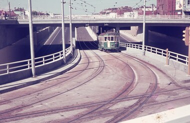
Slide - Set of 7, Keith Caldwell, 22/03/1969 12:00:00 AM
Set of seven Agfa colour slide, blue and white plastic mount, photo by Keith Caldwell on 22/3/1969 of the then new track work in Queensway St Kilda, closing the former track in Wellington St. .1 - W2 363 inbound, route 5 climbing the grade to the St Kilda Road Junction. Has the overpass in the background. .2 - W2 229 ditto .3 - W2 377 ditto waiting for another W2 5?6 crossing in front of the tram. .4 - SW6 941 outbound, route 5, Malvern Burke Road with advertisements for PGF golf clubs and Vodka Wyborowa. .5 - W2 421 outbound route 5. .6 - W2 347, East Brighton route 64 outbound in Queensway with the Windsor Fire Station and the former cable tram winding house (the big red building) in the background. .7 - A W2 inbound..1 and .6 has in pencil "22/3/1969".trams, tramways, st kilda rd, queensway, new tramway, route 5, east malvern, route 64, east brighton, w2 class, sw6 class, tram 363, tram 229, tram 377, tram 347, tram 421, tram 347, tram 941 -
 Melbourne Tram Museum
Slide - Set of 5, Ron Scholten, May. 1973
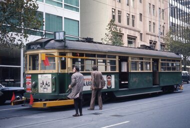
Set of five colour slides, white/red cardboard, Duplicates by Pacific Film Laboratories of tram 912 in the City area testing clearances around safety zones, as part of the development of the Z class tram. Done on a Sunday morning. .1 - Bourke St showing the various equipment or protrusions attached to the tram in order to test clearances to safety zones at crossings. .2 - about to travel through a crossover. .3 - using the Queen or William St crossover. Tram has adverts for Tolleys Brandy and PGF Golf clubs. .4 - ditto - with tram 1021 running a route 97 to North Fitzroy Park St. .5 - ditto- with adverts for Williamson Real Estate and All Saints winery. See also Reg Item 3795 for Black and White and Reg Item 4611 for photos of the event and the use of car 1018.All have a running number "1204" to "1208" and "912" written on the slide.trams, tramways, sw6 class, testing, safety zone, bourke st, safety, z class, north fitzroy, route 97, tram 912 -
 Federation University Historical Collection
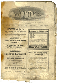
Magazine, Nature, 1910, 22/12/1910
This magazine was taken to Antarctica by Richard W. Richards, a member of Shackleton's expedition. Richards was a member of the Ross Sea Party. The item was returned to Dick Richards after L. Quartermain found it above Richards' bunk in Cape Evans in 1961 when a party were sent down by the New Zealand Government to clear the hut of ice. Richards later gave it to the donor because of the article on the swerve of cricket balls.This copy of Nature was used by Dick Richards when he was marooned at Cape Evans during the Shackleton Antarctic Expedition. The hut used by Richards and his party was also used by Captain Scott. The magazine dates before the use of the hut by Captain Scott so it may be assumed that it belonged to Scott or one of his party. In 1960, during ice being cleared from the hut, the magazine was found above Dick Richards' bunk and returned to him in 1961. It is therefore a remnant of the Shackleton Antarctic Expedition..1) A magazine called 'Nature', a weekly magazine of science, featuring beautiful advertisements and illustrations. .2) A note on a piece of cardboard written on by Dick Richards .3 An envelope addressed to Leslie B. Quartermain of the New Zealand antarctic Society, with the hand written note 'This copy of "Nature" was found embedded in ice in my bunk at C. Evans in Dec 1960..2) This copy of Nture was brought back from above my bunk in Cape Evans by L Quartermain in 1961. his party were sent down by NZ Govt to clear the hut of ice (250 tons removed) and restore to the condition when Scott and ourselves lived in it in 1911 - 12 and 1914 - 17. It contains an article by J.J. Johnson on swerve in cricket tennis and golf balls etc & settles an argument I often had re lat dip in of a ball [pist?]. The black is due to oily blubber smoke which permeated everything at Cape Evans. antarctica, ross sea, cape evans, nature, richards, dick richards, richard w. richards, scott, robert falcon scott, robert scott, scott of the antarctic, holioake, cricket, r.w. richards, microscope -
 Eltham District Historical Society Inc
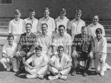
Photograph, Neil Ray, Ivanhoe Cricket Club 2nd Eleven; Premiers Sub-District Cricket Association 1964-1965, 1965
Back Row L-R: J. Vine, R. Pigdon, A. Munn, R. Brentnall, B. Harding, E. Hart Centre L-R: J. Mithen, L. Hutchins (Manager), R. Manuell (Captain), J. Manuell (Vice Captain), J. Rattenbury (President), R. James Front L-R: T. Golder, A. James B. Harding - Montmorency, Former President of Heidelberg Golf Club R. (Bob) Manuell (Capt.) - Former General Manager of Briar Hill Timber and Eltham Shire Councilor J. Manuell (Vice Capt.) - Deceased Robert (Alfie) James - Former Senior Umpire, Diamond Valley Cricket Association Tommy Golder - Austrealia Hockey player Anthony James - DeceasedPrinted on front face Ivanhoe Cricket Club 2nd Eleven; Premiers Sub-District Cricket Association 1964-1965 Names of players and photographerjoan castledine collection, j. vine, r. pigdon, a. munn, r. brentnall, b. harding, e. hart, j. mithen, l. hutchins, r. manuell, j. manuell, j. rattenbury, r. james, t. golder, a. james, robert (alfie) james, tommy golder, anthony james, ivanhoe cricket club, premiers sub-district cricket association 1964-1965, ivanhoe cricket club 2nd eleve, bob manuell -
 Orbost & District Historical Society
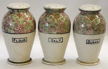
shakers, after WW11 (?)
These items were owned and used by Alice Pow (nee McWilliam), known as Maccie. Maccie was a nurse who came to Orbost in 1936. She was highly respected in Orbost for her nursing skills particularly during the 1938 outbreak of polio, Most patients were cared for in their homes and Miss McWilliam was sent out to care for them. Over 14 months she travelled 9560 miles supervising their treatments. She eventually married Mr Hec Pow who had been left to bring up his three daughters after his wife died.. The Pows lived in Orbost where Hec Pow was worked with his father Fred at the saw mill in Cabbage Tree. Maccie Pow was a member of the Orbost Bowling Club, Red Cross and Orbost Golf Club.Three vase shaped pottery shakers. Each has a cork stopper i n the base and sprinkle holes on the top. They are pale green coloured to half way and the rest is pale green with pink flowers. The surface is dimpled. On the base : ANDOVER Made in Japanchina tableware shakers pow-maccie mcwilliam-alice -
 Orbost & District Historical Society
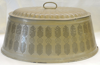
food cover, 1940's (?)
This item was owned and used by Alice Pow (nee McWilliam), known as Maccie. Maccie was a nurse who came to Orbost in 1936. She was highly respected in Orbost for her nursing skills particularly during the 1938 outbreak of polio, Most patients were cared for in their homes and Miss McWilliam was sent out to care for them. Over 14 months she travelled 9560 miles supervising their treatments. She eventually married Mr Hec Pow who had been left to bring up his three daughters after his wife died.. The Pows lived in Orbost where Hec Pow was worked with his father Fred at the saw mill in Cabbage Tree. Maccie Pow was a member of the Orbost Bowling Club, Red Cross and Orbost Golf Club.An oval shaped metal food cover made of pressed tin painted tan. It has a loop handle on the top. The sides slope outwards and it is seamed on both sides. The bottom edge is rolled. The sides have a perforated design for air flow.food food-protection kitchen-ware pow-maccie mcwilliam-alice -
 Warrnambool and District Historical Society Inc.
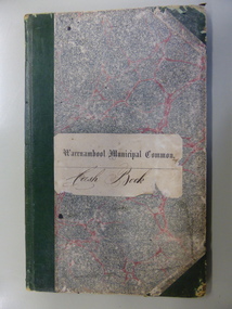
Ledger, Warrnambool Municipal Common, Circa 1865
This cash book contains entries which relate to the everyday operation of the Borough Common which predates the establishment of Warrnambool as a town. All ratepayers had the right to graze their cows on the common, with the cows being collected every morning by the herdsman and walked to the common. Entries relate to items such as eradication of thistles, repairs and erection of stock yards, burying of dead stock, purchase of bulls and clearing of waterholes. Salaries were paid to E. Margetts, D Allan, T Raingill, and M T Read. Auditors were James Dickson. After WW1 parts of the common were allocated to soldiers’ settlement blocks ranging from 18 to 30 acres. Other parts remained with the Crown for Municipal uses and part became the Warrnambool Golf Course. In 1925 the common was abolished.The entries in this book record the operations and earliest residents who were involved in the Common in the early days of WarrnamboolGrey and red mottled card cover with dark green points and spine. Paper label on front cover. Dark blue and tan mottled paper inside front and back covers. Warrnambool Municipal Common Cash Book.warrnambool borough, warrnambool common, e margetts, raingill, d allan, m t read, warrnambool common cash book -
 Warrnambool and District Historical Society Inc.
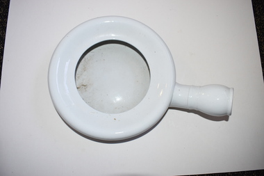
Bed pan, early 20th century
This antique bed pan, an object still in use in a more modern form in hospitals and other institutions, is from the collection of Dr Horace Iles Holmes (1877-1959). He was born and educated in Tasmania and completed a medical degree at the University of Melbourne. He commenced a medical practice in Warrnambool in 1906 and was the Honorary Medical Officer at the Warrnambool Hospital and Warrnambool’s Health Officer. His practice was at ‘Ierne’, at the corner of Spence and Kepler Streets. He was an early member of the Royal Australian College of Surgeons and he was prominent in community affairs in Warrnambool (foundation President of the Warrnambool Rotary Club, a member of the local Masonic Lodge for over 50 years, a long-term Trustee of the Warrnambool Methodist Church, a Warrnambool Hospital Committee member and president of the Lyndoch Hostel for the Aged committee). Dr Holmes enjoyed fishing, bowls and golf. This is an interesting medical item from the collection of Horace Iles Holmes, a doctor who was prominently associated with the professional and community life of Warrnambool for over 50 years. This is a white china bed pan in a circular shape with a smaller round spout attached. It has some staining. warrnambool, medical aids, dr horace holmes, history of warrnambool -
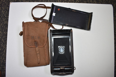 Warrnambool and District Historical Society Inc.
Camera and case, Early 20th Century
This is a camera that belonged to Dr Horace Iles Holmes (1877-1959). Born and educated in Tasmania, Dr Holmes completed his medical degree at Melbourne University. He commenced a medical practice in Warrnambool in 1906 and was the Honorary Medical Officer at the Warrnambool Hospital and Warrnambool’s Health Officer. His practice was at ‘Ierne’, at the corner of Spence and Kepler Streets. He was an early member of the Royal Australian College of Surgeons and was prominent in community affairs in Warrnambool (foundation President of Warrnambool Rotary Club, a member of the local Masonic Lodge for over 50 years, the Warrnanbool Hospital Committee member, long-term Trustee of the Warrnambool Methodist Church and President of the Lyndoch Hostel for the Aged Committee. Dr Holmes also had agricultural interests and enjoyed bowls, golf and fishing. This is an interesting item as it comes from the Horace Holmes collection and he was a doctor who was prominently associated with the professional and community life of Warrnambool for well over 50 years. .1 This is a camera with an inside concertina mechanism and an outer covering of brown leather and silver-coloured metal. The camera has a leather handle and is scuffed and rusted in parts. .2 The cover is made of brown cloth and has leather tabs on the sides and on the tab fastener. The fastener has a metal buckle. There is a leather strap for carrying the camera and cover over the shoulder. The initials of the owner have been printed in ink on the front of the cover which is worn in places and torn at the bottom corner. H.I.H.dr horace iles holmes, warrnambool, history of warrnambool, cameras, photographic equipment -
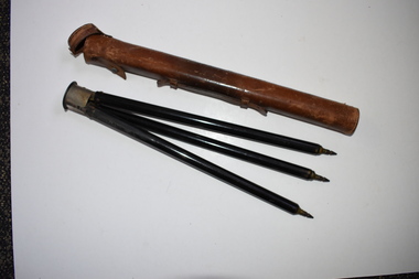 Warrnambool and District Historical Society Inc.
Camera tripod and case, Early 20th century
This item belonged to Dr Horace Iles Holmes (1877-1959). He was born and educated in Tasmania and completed a medical degree at Melbourne University. He commenced a medical practice in Warrnambool in 1906 and was the Honorary Medical Officer at the Warrnambool Hospital and Warrnambool’s Health Officer. His practice was at ‘Ierne’ at the corner of Spence and Kepler Streets. Dr Holmes was an early member of the Royal Australian College of Surgeons and was prominent in Warrnambool community affairs (foundation President of the Warrnambool Rotary Club, a member of the local Masonic Lodge for over 50 years, a Warrnambool Hospital Committee member, a long-term Trustee of the Warrnambool Methodist Church and President of the Lyndoch Hostel for the Aged Committee). Dr Holmes also had many recreational interests, including fishing, bowls and golf. This item is of considerable interest as one coming from the collection of Horace Iles Holmes, a doctor who was prominently associated with the professional and community life of Warrnambool for well over 50 years..1 This is a cylindrical-shaped brown leather case with white stitching along the sides and at the ends. The top end has a leather lid attached to the body of the case with a metal pin. The leather attachment here is broken away. On the side of the case is a leather handle. The case is much scuffed. .2 This is a metal tripod with three legs and pointed ends for embedding into the ground area. The three legs sit on a rounded metal top with a screw for attachment to a camera. The metal top has white printing. The top part of the tripod is slightly rusted. ‘Normal Marque Deposee’warrnambool, dr horace holmes, photographic accessories, history of warrnambool -
 Kew Historical Society Inc
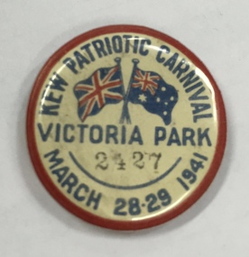
Badge, Kew Patriotic Carnival, Victoria Park, March 28-29 1941, 1941
A Kew Patriotic Carnival was held in Victoria Park in 1941. The event was promoted in the Argus newspaper as: "KEW CARNIVAL - A carnival, at which more than 25 local organisations will co-operate in raising funds for Kew Patriotic Society, will be opened at Victoria Park. Kew this afternoon. The carnival will begin at 2 p.m. to-day and will continue to-morrow. There will be afternoon and evening sessions each day. Arrangements have been made for open-air dances, bicycle races, athletic events, tennis tournaments, folk dancing, miniature golf, and a shooting gallery. Flowers, sweets, cakes, and re-freshments will be sold at stalls conducted by auxiliaries, and lucky envelopes, darts competitions, spinning-wheels, and games will be among the attractions." The Argus (Melbourne) Friday 28 March 1941, Page 6.Rare example of Second World War local Kew memorabiliaPatriotic button. Kew Patriotic Carnival March 28-29 1941. Victoria Park. Numbered 2427. The design incorporates the British and Australian flags.Title: "Kew Patriotic Carnival, Victoria Park, March 28-29 1941". Number "2427"kew patriotic carnival, patriotic buttons, ww2 -
 Kew Historical Society Inc
Photograph - Flooding of the Yarra Valley at Kew East, 1974
Flooding of the Yarra Valley, including that section of the Yarra bordering Kew and Kew East in the north and west of the municipality, was a regular occurrence. Extreme flood events of the Yarra River are recorded to have occurred in 1891, 1901, 1916, 1923 and 1934. The Municipality of Kew's response to these floods was to enact planning decisions restricting residential development in flood prone areas following the floods of 1916, 1921 and 1934. While floods continued after the development of the Upper Yarra Reservoir (construction 1948-57), the regularity and extent of these inundations diminished. During the nineteenth century, the land abutting the south side of the Yarra in Kew was devoted to dairy farming. In the twentieth century, before and after the construction of the Eastern Freeway, much of this low-lying area was used as golf courses and public parks.Late example of the capacity of the Yarra Valley at Kew to flood, even though drainage works and the Upper Yarra Reservoir had reduced their regularity.Original black and white print photograph of the low-lying land at East Kew under floodwater on 16 May 1974. The vantage point of the photographer is Lister Street. In the photo, the fences of the Kilby Farm can be seen. Flooding was caused by overflowing water in Glass' Creek and the River Yarra. Annotation verso: "Hay's Paddock op No.30 Lister Street / 16 May 1974 11.50am / R.L. 46.04"hays paddock, floods, yarra river, glass' creek, lister street -
 Kew Historical Society Inc
Photograph - Flooding of the Yarra Valley at Kew East, 1974
Flooding of the Yarra Valley, including that section of the Yarra bordering Kew and Kew East in the north and west of the municipality, was a regular occurrence. Extreme flood events of the Yarra River are recorded to have occurred in 1891, 1901, 1916, 1923 and 1934. The Municipality of Kew's response to these floods was to enact planning decisions restricting residential development in flood prone areas following the floods of 1916, 1921 and 1934. While floods continued after the development of the Upper Yarra Reservoir (construction 1948-57), the regularity and extent of these inundations diminished. During the nineteenth century, the land abutting the south side of the Yarra in Kew was devoted to dairy farming. In the twentieth century, before and after the construction of the Eastern Freeway, much of this low-lying area was used as golf courses and public parks.Late example of the capacity of the Yarra Valley at Kew to flood, even though drainage works and the Upper Yarra Reservoir had reduced their regularity.Original black and white print photograph of the low-lying land at East Kew under floodwater on 16 May 1974. The vantage point of the photographer is Lister Street. Flooding was caused by overflowing water in Glass' Creek and the River Yarra. Annotation verso: "Lister Street looking north / Flood level / 16 May 1974 11.30am / R.L. 46.04"hays paddock, floods, yarra river, glass' creek, lister street -
 Kew Historical Society Inc
Photograph - Flooding of the Yarra Valley at Kew East, 1974
Flooding of the Yarra Valley, including that section of the Yarra bordering Kew and Kew East in the north and west of the municipality, was a regular occurrence. Extreme flood events of the Yarra River are recorded to have occurred in 1891, 1901, 1916, 1923 and 1934. The Municipality of Kew's response to these floods was to enact planning decisions restricting residential development in flood prone areas following the floods of 1916, 1921 and 1934. While floods continued after the development of the Upper Yarra Reservoir (construction 1948-57), the regularity and extent of these inundations diminished. During the nineteenth century, the land abutting the south side of the Yarra in Kew was devoted to dairy farming. In the twentieth century, before and after the construction of the Eastern Freeway, much of this low-lying area was used as golf courses and public parks.Late example of the capacity of the Yarra Valley at Kew to flood, even though drainage works and the Upper Yarra Reservoir had reduced their regularity.Original black and white print photograph of Hay's Paddock under floodwater on 16 May 1974. The vantage point of the photographer is Keystone Crescent looking east. Flooding was caused by overflowing water in Glass' Creek and the River Yarra. Annotation verso: "Keystone Cr looking east / 16 May 1974 11.50am"hays paddock, floods, yarra river, glass' creek -
 Kew Historical Society Inc
Photograph - Flooding of the Yarra Valley at Kew East, 1974
Flooding of the Yarra Valley, including that section of the Yarra bordering Kew and Kew East in the north and west of the municipality, was a regular occurrence. Extreme flood events of the Yarra River are recorded to have occurred in 1891, 1901, 1916, 1923 and 1934. The Municipality of Kew's response to these floods was to enact planning decisions restricting residential development in flood prone areas following the floods of 1916, 1921 and 1934. While floods continued after the development of the Upper Yarra Reservoir (construction 1948-57), the regularity and extent of these inundations diminished. During the nineteenth century, the land abutting the south side of the Yarra in Kew was devoted to dairy farming. In the twentieth century, before and after the construction of the Eastern Freeway, much of this low-lying area was used as golf courses and public parks.Late example of the capacity of the Yarra Valley at Kew to flood, even though drainage works and the Upper Yarra Reservoir had reduced their regularity.Original black and white print photograph of the low-lying land at East Kew under floodwater on 16 May 1974. The vantage point of the photographer is Lister Street. Flooding was caused by overflowing water in Glass' Creek and the River Yarra. Annotation verso: "Lister St looking same as No.3 / 16 May 1974 11.30"floods, yarra river, glass' creek, lister street -
 Kew Historical Society Inc
Photograph - Flooding of the Yarra Valley at Kew East, 1974
Flooding of the Yarra Valley, including that section of the Yarra bordering Kew and Kew East in the north and west of the municipality, was a regular occurrence. Extreme flood events of the Yarra River are recorded to have occurred in 1891, 1901, 1916, 1923 and 1934. The Municipality of Kew's response to these floods was to enact planning decisions restricting residential development in flood prone areas following the floods of 1916, 1921 and 1934. While floods continued after the development of the Upper Yarra Reservoir (construction 1948-57), the regularity and extent of these inundations diminished. During the nineteenth century, the land abutting the south side of the Yarra in Kew was devoted to dairy farming. In the twentieth century, before and after the construction of the Eastern Freeway, much of this low-lying area was used as golf courses and public parks.Late example of the capacity of the Yarra Valley at Kew to flood, even though drainage works and the Upper Yarra Reservoir had reduced their regularity.Original black and white print photograph of the low-lying land at East Kew under floodwater on 16 May 1974. The vantage point of the photographer is at Willsmere Road. The road itself is underwater.Annotation verso: "Willsmere Rd / Same as No.7 / 16 May 1974 11.15am"floods, yarra river, willsmere road -
 Kew Historical Society Inc
Photograph - Flooding of the Yarra Valley at Kew East, 1974
Flooding of the Yarra Valley, including that section of the Yarra bordering Kew and Kew East in the north and west of the municipality, was a regular occurrence. Extreme flood events of the Yarra River are recorded to have occurred in 1891, 1901, 1916, 1923 and 1934. The Municipality of Kew's response to these floods was to enact planning decisions restricting residential development in flood prone areas following the floods of 1916, 1921 and 1934. While floods continued after the development of the Upper Yarra Reservoir (construction 1948-57), the regularity and extent of these inundations diminished. During the nineteenth century, the land abutting the south side of the Yarra in Kew was devoted to dairy farming. In the twentieth century, before and after the construction of the Eastern Freeway, much of this low-lying area was used as golf courses and public parks.Late example of the capacity of the Yarra Valley at Kew to flood, even though drainage works and the Upper Yarra Reservoir had reduced their regularity.Original black and white print photograph of the low-lying land at East Kew under floodwater on 16 May 1974. The photograph is of Hyde Park looking north-east.Annotation verso: "Hyde Park looking nth-east / Flood Level / 16 May 1974 11.15am / R.L. 46.61"floods, yarra river, hyde park -
 Kew Historical Society Inc
Photograph - Flooding of the Yarra Valley at Kew, 1974
Flooding of the Yarra Valley, including that section of the Yarra bordering Kew and Kew East in the north and west of the municipality, was a regular occurrence. Extreme flood events of the Yarra River are recorded to have occurred in 1891, 1901, 1916, 1923 and 1934. The Municipality of Kew's response to these floods was to enact planning decisions restricting residential development in flood prone areas following the floods of 1916, 1921 and 1934. While floods continued after the development of the Upper Yarra Reservoir (construction 1948-57), the regularity and extent of these inundations diminished. During the nineteenth century, the land abutting the south side of the Yarra in Kew was devoted to dairy farming. In the twentieth century, before and after the construction of the Eastern Freeway, much of this low-lying area was used as golf courses and public parks.Late example of the capacity of the Yarra Valley at Kew to flood, even though drainage works and the Upper Yarra Reservoir had reduced their regularity.Original black and white print photograph of the low-lying land at East Kew under floodwater on 16 May 1974. The photograph is taken from 43 Kellett Grove.Annotation verso: "Kellett Gve No.43 / Flood Level / 16 May 1974 11.40am"floods, yarra river, kellett grove -
 Vision Australia
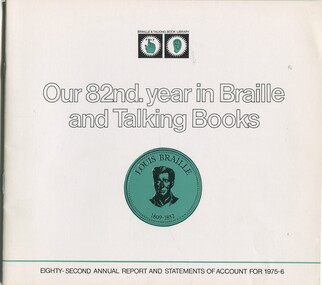
Administrative record - Text, Our 82nd year in Braille and Talking Book: eighty-second annual report and statements of account for 1975-6, 1976
Annual report of the Braille & Talking Book Library including Minutes of the AGM, Board of Director's Report, President's report and financial statements. Items also included are: Colvan Charity Cup Golf Day raffle winner receives car from Bib Stillwell, Frank Moorhouse wins Braille Book of the Year with Barrett Reid, Dr Stephen Murray-Smith and Lloyd O'Neil making up the judging panel, luncheon to celebrate Alice McClelland's 54th year of service to the library, rationalisation of Moon books with RBS NSW, popularity of Fraser Twins Sound magazine, retirement of published Lloyd O'Neil from judging panel and appoint of Joyce Nicholson, death of Joan Armytage, former auxiliary organiser then committee member and renovation of library and construction of talking book room and recording studios (in notes to accounts).1 volume of print and illustrationsbraille and talking book library, annual reports -
 Melbourne Legacy
Document, Australia's Legacy is Worth Defending, 2006
A document summarising the work of Legacy in 2006. It mentions how it was begun by a group of WW1 veterans. At the time there were 126,000 widows and 1,900 children and adults with a disability being helped by Legacy around Australia. There were approximately 6,700 Legatees in 49 Legacy Clubs. In Victoria there were 1,700 Legatees providing support to about 24,000 widows and 300 disabled dependents. There were 13 clubs in Victoria as well as 12 Groups, plus Branches. Some of the activities Legacy was involved with include a National Junior Public Speaking Award, Badge appeal, ALbert Park Lake Defence Attack, a golf classic event and the Torch society Document was from a folder of documents donated to the archive by Legatee Bill Rogers that related to his time as President (March 2006 - March 2008).A summary of the work of Legacy in 2006.Print out x 2 pages about Legacy, its history and challenges.legatees, statistics -
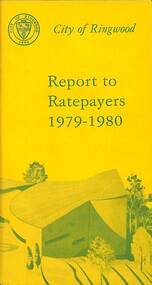 Ringwood and District Historical Society
Booklet, City of Ringwood Report to Ratepayers 1979-1980, 1979
Yellow covered community information booklet for Ringwood residents covering Council and Parliamentary contact details, Council Meeting Dates, Justices of the Peace, Council Finances, Immunizations, Major Works, Planning (Live Theatre/Functions Centre, including Floor Plan), Health and Community Services, Christmas Holiday Play Centres, Lord Mayor's Children's Camp, Rates, Municipal Elections, Dogs, Rubbish Tip, Overhanging Foliage, Vandalism, Building By-laws, Ringwood Library (28 Warrandyte Road), Golf Course, Fred Dwerryhouse Swimming Centre, Netball Complex, Growth of Ringwood Commercial Centre, McAlpin's Reserve Development Plan, Netball Complex, Citizenship Ceremonies, Mini Bikes, School Crossing Supervision, Family Fun Day, Highland Carnival. Includes three City of Ringwood Free Tipping Vouchers valid until the end of 1980 and list of tip charges from October, 1979.Mayor's Message - Cr. P. Gotlib. Inside front cover - Green tinted photograph of Ringwood Memorial Tower captioned: Ringwood - "A Happening Community". Back cover - Green and yellow diagram of Ringwood Civic Centre Development, Stage 2. Floor Plan and description of Theatre and Functions Centre expected to be completed by early 1980.rinx -
 Southern Sherbrooke Historical Society Inc.
Information folder - Belgrave South Timber & Hardware
Information folder containing items pertaining to the Belgrave South Timber & Hardware business. Contents: -receipt, Belgrave South Building Supplies, dated 27 October 1961, to Edelston Brothers. -blotter, Belgrave Sth & Heights District free blotter, with advertisements for local business, inc. Belgrave South Building Supplies. -letter, informing suppliers of change of name from Belgrave South Building Supplies to Belgrave South Timber & Hardware, effective 1 November 1961. Also small photo attached. -advertisement, from Free Press, dated 3 October 1963. Also handwritten note, "We now have an advertising manager" -various advertisements (6 pages). -telegram, 10 March 1966 (?), from Michael's Hardware, Bowen QLD, to Belgrave South Building Supplies. -advertisement./invitation, South Australian Sawmillers Association Golf Day and Radiata Pine Association inspection tour, including photographic highlights from previous tours.belgrave south building supplies -
 Kew Historical Society Inc
Plan - Subdivision Plan, J R Mathers & McMillan, Willsmere Park Estate, c.1940
Pru Sanderson, in her groundbreaking ‘City of Kew Urban Conservation Study : Volume 2 - Development History’ (1988), summarised the periods of urban development and subdivisions of land in Kew. The periods that she identified included 1845-1880, 1880-1893, 1893-1921, 1921-1933, 1933-1943, and Post-War Development. These periods were selected as they represented periods of rapid growth or decline in urban development. An obvious starting point for Sanderson’s groupings involved population growth and the associated economic cycles. These cycles also highlighted urban expansion onto land that was predominantly rural, although in other cases it represented the decline and breakup of large estates. A number of the plans in the Kew Historical Society’s collection can also be found in other collections, such as those of the State Library of Victoria and the Boroondara Library Service. A number are however unique to the collection.The Kew Historical Society collection includes almost 100 subdivision plans pertaining to suburbs of the City of Melbourne. Most of these are of Kew, Kew East or Studley Park, although a smaller number are plans of Camberwell, Deepdene, Balwyn and Hawthorn. It is believed that the majority of the plans were gifted to the Society by persons connected with the real estate firm - J. R. Mathers and McMillan, 136 Cotham Road, Kew. The Plans in the collection are rarely in pristine form, being working plans on which the agent would write notes and record lots sold and the prices of these. The subdivision plans are historically significant examples of the growth of urban Melbourne from the beginning of the 20th Century up until the 1980s. A number of the plans are double-sided and often include a photograph on the reverse. A number of the latter are by noted photographers such as J.E. Barnes. In 1910, the Willsmere Park Estate Dairy was lauded in the Box Hill Reporter as ‘an object lesson in dairying’. Ten years later, in 1923, it was to be sold. The first subdivision of the Estate included 77 grand allotments with frontages to Belford and Kilby Roads, Elm and Willow Groves, and Acacia Avenue. Every lot was claimed to be ‘high and dry’, and with panoramic views of Kew and East Kew. The balance of the Estate, and the largest proportion of allotments was to be subdivided and sold from 1940. This second sale included 109 lots fronting Kilby Road and Elm and Willow Groves. Annotations on the plan indicate that the more expensive lots faced Belford Road opposite the Kew Golf Links. Two of these sold for £310. Lots further to the west in Willow Grove were sold for £60 less. Many of the houses to be built on these 109 allotments after the War faced Government restrictions on building materials and the dimensions of each house due to postwar shortages.subdivision plans - east kew, willsmere park estate -
 Melton City Libraries
Photograph, Denominational Church and School, Unknown
Presbyterian Church Melton Background: A Combined Denominational Church and School was established in Melton by Protestants from the Presbyterian, Episcopalian, Wesleyan and Baptists denominations. A wooden church was built on the flat area east of the Toolam Toolern Creek. A photo of this church shows the buildings with small houses nearby. In the background the bluestone Presbyterian Church built in 1867 can be seen to the north on Yuille and Sherwin street. The flat area beside the road to Ballarat was subject to flooding and the site was eventually abandoned for a settlement. By the latter part of the 1860s the Church of England and Wesleyan bluestone churches were also being erected in the centre of the township of Melton. The commercial centre developed in High Street from Smith to Palmerston Street. Township of Melton Crown Grants Issued Under Common Law refers to the site of the Combined Denominational Church and School on the east side of Sherwin Street on the corner of Pyke Street. Section 4 Allotments 1 and 10 situated on the corner of Pyke, Bryan and Sherwin Street. The early map has the name of Thomas Cridge on this site. The area known Common (flat) remained open level ground with some cottages and buildings and a milk cooler in the 1930s, Granny Watts house “Lynch Cottage was moved in 1964. Sherwin Street was used until the 1960s with the open area being the used for playing golf. Alterations to the flat occurred when the golf course added to the height and removed the Sherwin Street access. The greens were developed and the height of ground altered the vista across Common. The first Presbyterian Minister in the district was the Reverend Alexander McNicol an advanced student and an experienced missionary from Glasgow, arriving in Melbourne in 1850. He was ordained on the 8th of June and was called to the Bacchus Marsh and Mount Macedon district. On the 1st of May 1851 he was called to Geelong and returned to Bacchus Marsh on February 1856 remaining until July 1859. Group of people in front of the church and school.churches, local identities, education -
 Orbost & District Historical Society
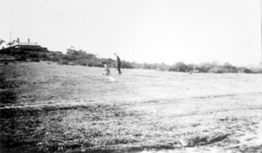
black and white photographs, Snowy River Mail, 1960s
These photographs were taken at the annual Orbost Agricultural Show at the Newmerella Showground. They were probably published in the Snowy River Mail newspaper. Some of the Orbost identities pictured include : Russell Crofts, Kevin McDonald, Brian McDonald, Gail & Lee Winchester, Julie & Lisa Drummond, Marion Russell, Sylvia MurrayRod Kleinitz, Rober Morgan, Trevor Perry, Brian Woodlands, anna light, Louella Brunt, Colin Weir, Wendy Pinnock, Raeleen Reed, Margaret Joiner and Jo-anne Mundy. The first meeting to form an Agricultural society in Orbost was convened by the then Orbost Progress Association and held in the Mechanics Hall on Saturday, 10th October 1891. Its first show was held on 3rd March 1904...on a site alongside the Bonang Road where the present Golf Club stands. It is currently held at the Recreation Reserve at Newmerella. (Ref: In Times Gone By-Deborah Hall)These photographs are associated with the Orbost Agricultural Society 's Annual Show which has been a major event in Orbost for over a century. Agricultural shows are an important part of cultural life in small country towns and the Orbost Show is an integral part of Orbost 's agricultural history. Seventeen black / white phootgraphs which were taken at the Orbost Agricultural Show.orbost-agricultural-show -
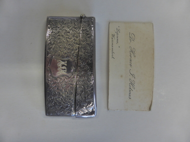 Warrnambool and District Historical Society Inc.
Functional object - Silver Card Case (Holmes), Mid 20th century
The owner of this card case was Dr Horace Holmes who was a doctor in Warrnambool for over 40 years. Dr Holmes (1877-1959) was born in Tasmania and completed a medical course at Melbourne University. He came to Warrnambool in 1905, taking over the practice of Dr Fleetwood at ‘Ierne’, at the corner of Spence and Kepler Streets. In 1906 he built a new home at the corner of Liebig Street and Raglan Parade and moved his practice there in 1912 (today this building is the Warrnambool Medical Clinic). Dr Holmes was an honorary Medical Officer at the Warrnambool Hospital. He retired in 1939 selling his practice to Dr Berryman but came out of retirement and practised as a locum until 1944. His interests included rowing golf, bowls and fishing. In the 1950s he lived at ‘Leprena’ in Canterbury Road. He was a foundation member of the Warrnambool Rotary Club. This is a most significant item as it belonged to a prominent local doctor, Dr Horace Holmes. It also has considerable social significance as it is an example of the practice of past times of carrying calling cards and the silver case is a sign of the affluence of the owner. This is a silver card case, heavily embossed, with a slightly curved shape and a hinged lid. It has the initials ‘HIH’ engraved in a shield on the front of the case. It contains nine calling cards (Dr Horace Holmes, Warrnambool). These are made of light card with printing in black on a white background. The cards are somewhat marked and discoloured. Case: ‘HIH’ Cards: ‘Dr. Horace I. Holmes, Leprena, Warrnambool’card case, dr horace holmes, warrnambool -
 Surrey Hills Historical Society Collection
Photograph, Land in Everton Grove, Surrey Hills in 1927, 1927
The vacant land was the site of Norman Carter's future home at 21 Everton Grove. Norman Broadley Carter (1899-1984) married Mabel Annie Moore in 1927. Norman was an engineer with a passion for photography. Norman took many photos of Surrey Hills and Mont Albert from the 1920s and particularly of events and activities of the Church of England. For many years the house on the left located at 14 Harding Street belonged to the Kenneth Rothwell Culliton and his wife (Fanny) Molly Culliton. The house is located next to the Harding Street Reserve. Ken was an engineer and Molly was an early member of the Surrey Hills Historical Society. Ken was born and died in Surrey Hills. His father Harry Culliton was a well known golfer. His mother Christina Mary Rothwell was the daughter of Thomas Talbot Rothwell, known as a tea merchant and importer; also lived in Surrey Hills. This image is significant for its documentation of pre-urban Surrey Hills.Black and white photo of an area of gently sloping mown grass. On the horizon is a line of trees and on the LHS the outline of a (?) Victorian house can be seen. A man and a young boy are playing in the open space.everton grove, harding street, kenneth rothwell culliton, miss fanny molly arthur, mrs fanny molly culliton, norman broadley carter, mabel annie moore, mabel annie carter -
 Federation University Historical Collection
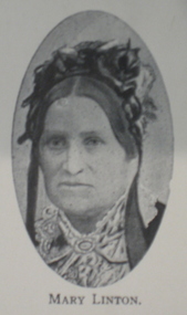
Booklet, H.P. Benett, Looking back over 100 Years. 1839-1939: A Brief Historical Review on the Settlement and Development of Linton and District, 1939
This book was published for the centenary of white settlement at Linton. Wardy Yallock is the Aboriginal name for the district now know as Linton.Soft cream covered booklet of 42 pages. Topics include pioneers; gold; mining; civic development; municipal history, education, churches, racing, athletics, football, rifle shooting;tennis, golf;fire brigade, band, horticultural society, Linton Free Library; friendly ; societies; post office; railway; police; war; old Lintonians' Association. Images include: Ewen Rankin; Robert Rankin; John Linton; R. Ching; Mary Linton; James Nicol; J.H. Roberts; W.G. Bennett; Robert Linton; Digory Roberts; W. Campbell; W. Todd; B. Oulten; W. White; Rev. Campbell; J. Wearne; J.G.Allan; R.S. Nelson; Victory Mine; South Victoria Mine; Samuel Lewers; M.H. Baird; Thomas Younghusband; Joseph Shepherd; Thomas Kennedy; John Clarke; James Dodds; G.H. Smith; Linton State School; Sussex Street Linton Looking north; Sussex Street Linton looking South; Albert Kennedy; N. Wishartlinton, lintons diggings, wardy yallock, george sandow, mt bute station, emu hill, matthew hamilton, samuel lewers, john clarke, joseph shepherd, edward morey, james nicol, wg bennett, edwin ball, thomas bryant, william white, ewen cameron, john cameron, bryson campbell, james woodrow -
 Bendigo Historical Society Inc.
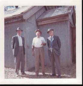
Photograph - MAGAZINE - BETWEEN BOTANICAL GARDENS AND SIMPSON'S ROAD
Photo: Note on back of photo states Öutside the Magazine '- coloured photo of three men standing in front of corrugated iron shed. Description attached reads' all the explosives for the mines in this area were stored here. A formed track runs to the door with earthworks all around to guard against blast. A trolley ran from each building on a wooden track. Wheels were copper. Two buildings formed the magazine, one in front of the other. This was to store caps and other explosives. Inside the magazine are numerous racks. Externally buildings were provided with copper lighting arrestors, later removed by vandals. Still to be seen are tracks in asphalt where woollen ( wooden ? ) rails ran. A good metal road ran right to magazine ( gravel) In front of the magazine building is botanical gardens area ( between it and Simpsons Road ). A cricket pitch also in the area more to the rear of Fitzpatrick's Hotel. Eaglehawk's first golf course is said to be in this area. Magazine keepers house still stands next to McLelland ( water bailiff )eaglehawk, powder magazine, eaglehawk, powder magazine, magazine, simpsons road, botanical gardens. -
 Orbost & District Historical Society
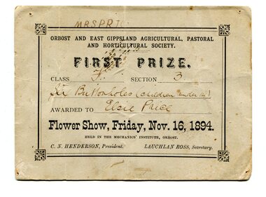
certificate/award, 1894
Orbost and East Gippsland Agricultural, Pastoral & Horticultural Society held their annual show in the Mechanics' Institute hall in Orrbost on November 16, 1894. First Prize in Class F Section C was awarded to Elsie Price for "six buttonholes (children under 14)". At this time C.N. Henderson was President and Lauchlan Ross was Secretary. The first meeting to form an Agricultural society in Orbost was convened by the then Orbost Progress Association and held in the Mechanics Hall on Saturday, 10th October 1891. Its first show was held on 3rd March 1904, on a site alongside the Bonang Road where the present Golf Club stands. It is currently held at the Recreation Reserve at Newmerella. Ref: In Times Gone By-Deborah Hall Prior to the Orbost Agricultural Society 's Annual Show these smaller shows were held in the Mechanics' Institute hall. Elsie Price, 1886-1897, was the daughter of David J and Mary Faithfull.This item is associated with the Orbost Agricultural Society 's Annual Show which has been a major event in Orbost for over a century.A original rectangular white paper certificate. Text is inside a border- all print is black. Details are handwritten.On back - many names. On front -"Mrs Price"award agricultural-show public-event