Showing 25607 items matching "plenty-township-estate"
-
 Greensborough Historical Society
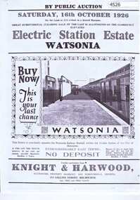
Advertising Leaflet, Electric Station Estate; Watsonia; Saturday 16th October 1926, 16/10/1926
One of two brochures advertising the auction on 16th October 1926 of the last 50 allotments of the Electric Station Estate, with a photograph of the railway station. Refer to item 4503 for other brochure.1p. B & W Photocopy of auction brochure, with photograph of new Watsonia Railway Station.watsonia railway station, watsonia -
 Melbourne Tram Museum
Drawing, Melbourne & Metropolitan Tramways Board (MMTB), Aerial photographs Bundoora Tram Extensions, Plenty Road – MMTB Drawings – 12/1979, Bundoora Extension – Metropolitan Transit Authority – 2/1983, John-Connell – Mott Hay and Anderson – Preliminary drawings for the Latrobe Modal Interchange – August 1984, 1979 to 1984
Set of drawings for the MMTB Plenty Road extension in 1979, MTA extension to Bundoora in 1983 and the Latrobe Uni Modal Interchange - 1984. Large print – Aerial photographs Bundoora Tram Extensions Stage 2 – Albert St to Kingsbury Drive Stage 3 – Kingsbury Drive to Settlement Road Has been rolled, left hand edge damaged, right hand edge torn Compiled by the ROW Division – 2/1981. Has written on rear at right hand end “Bundoora Tram Extension – Official MMTB Plans” 760H x 1190W Plenty Road – MMTB Drawings – 12/1979 P15123 Tyler St to Walsal Avenue P15124 Walsal Ave t McColl St P15125 McColl St to Dorrington Avenue Bundoora Extension – Metropolitan Transit Authority – 2/1983 P15400 Dorrington Avenue to Barwon Avenue P15401 Barwon Avenue to Nicholson Ave P15402 Nicholson St to Barling Park P15403 Barling Park to Darebin Creek P15404 Darebin Creek to Scott Grove P15405 Scott Grove to Clunes Street P15406 Clunes St to Cash St P15408 Cash St to Bundoora Park P15409 Bundoora Park to Larundel Hospital P15410 At Larundel Hospital P15411 Larundel Hospital to Marne Court P15412 Marne Court to Cherrywood Court P15413 Cherrywood Court to Morwell Ave P15414 Morwell Ave to Grimshaw St P15415 Grimshaw St to Nickson Street P15416 Nickson St to McLeans Road John-Connell – Mott Hay and Anderson – Preliminary drawings for the Latrobe Modal Interchange – August 1984. 8094-A-20 Set Out Plan and Paving Details 8094-A-21 Elevations 8094-A-22 Sections 8094-A-23 Roof Plan and Stormwater Layout 8094-A-24 Canopy Details 8094-A-25 Toilet Block and Waiting Room 8094-A-28 Miscellaneous DetailsOn rear of aerial photograph sheet - at right hand end “Bundoora Tram Extension – Official MMTB Plans” in felt pen.trams, tramways, plenty rd, bundoora, latrobe university, mmtb, construction, mta -
 Eltham District Historical Society Inc
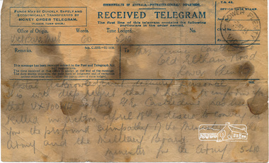
Telegram, Telegram, Victoria Barracks, Melbourne to Mrs Annie Castledine, Old Eltham Road, Lower Plenty, 3 May 1941, 3 May 1941
"Postal acknowledgement delivery personal" "It is with deep regret that I have to inform you that VX10044 Sapper G. E. Castledine has been killed in action April 18th & desire to convey to you the profound sympathy of the Minister for the Army and the Military Board. - Minister for the Army" Sapper George Ernest Castledine (1914-1941), son of Arthur Frederick and Annie Castledine, enlisted 23 January 1940 at Lower Plenty and was assigned to the 2/2 Field Company. He is buried in the Phaleron War Cemetery, Athens, Greece and is remembered on the Roll of Honour at Eltham.George was the first soldier from the Shire of Eltham to be killed in the Second World War. The telegram is oil stained as it was kept by George's brother Sid in his toolbox.Digital image of original held in private collection of Joan Castledine (niece of George Ernest Castledine and daughter of Sid and Polly (nee Arrowsmith) Castledine).Original bears oil stains from being stored in a tool box2/2 field company, aif, annie castledine, arthur frederick castledine, eltham war memorial, george ernest castledine, military, minister for the army, roll of honour, second word war, sid castledine, telegram -
 Eltham District Historical Society Inc
Photograph, Looking Back, Looking Forward: Summer Fun in Yarra Plenty exhibition launch, Nillumbik Shire Community Gallery, Eltham Library, 5 December 2019, 5 Dec 2019
Official opening, Thursday 5 December at 2.30pm of exhibition held 5 December 2019 - 6 January 2020 in the Eltham Community Gallery, Eltham Library Eltham District Historical Society is a member of the Yarra Plenty Heritage Group, which together with the Nillumbik U3A Painting and Drawing Group participated in an exhibition of historical photographs and original artworks side by side in a celebration, at the Eltham Library Community Gallery, of all things summer - picnics, swimming, boating, horsing around and enjoying nature with family and friends during long summer days. 56 Born Digital images2nd eltham sea scouts, andrew ross museum, eltham district historical society, eltham library, exhibition, greensborough historical society, heidelberg historical society, museums australia (victoria), nillumbik historical society, nillumbik reconciliation group, nillumbik shire council, nillumbik u3a drawing and painting group, roving curator, st andrews/queenstown historical society, u3a, yarra plenty heritage network, yarra plenty regional library -
 Melbourne Tram Museum
Document, Victorian Parliament, "The Plenty Road, Preston, Tramway Extension Inquiry", 1967
Report by the Victorian Parliamentary Public Works Committee on "The Plenty Road, Preston, Tramway Extension Inquiry" - 1967. The inquiry examined the MMTB's proposal to extend the East Preston line 0.7miles or 1.3km. The Committee took evidence from the MMTB, bus operators, the Victorian Railways, residents, La Trobe University, Preston City Council and others. The Committee recommended against the proposal. The report lists those members of Parliament involved. The line was subsequently extended by 1.2 kilometres from Tyler Street to Boldrewood Parade during 1983 and subsequently to Bundoora. Demonstrates the method of holding parliamentary inquiries into new tram lines.Document - report - 9 pages stapled in top left-hand corner, printed with a spirit duplicator.tramways, parliament, new lines, east preston, inquiries, bundoora, plenty road -
 Vision Australia
Text, Letter to V.S. Hollow regarding M.A. Aston Estate, 16/2/1951
Letter to Mr V.S. Hollow in response to his requests for information regarding execution of the M.A. Aston Estate. "Dear Sir, M.A. Aston Estate Your letter dated 20th December was hand delivered to me at 12.15 today. In answer thereto, I have to advise: 1. Mr Paterson is William Henry Paterson. Mr Worrall is Albert Victor Worrall. 2. The stock comprises two blocks 300 pounds and 200 pounds totalling 500 pounds. Yours faithfully, General Secretary1 torn half of a carbon copy pageassociation for the advancement of the blind -
 Whitehorse Historical Society Inc.
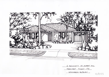
Artwork, other - Ink Line Drawing, Margaret Picken, 2 Bennett St., Forest Hill, 1994
A property illustration by Margaret Picken Commissioned by the real estate agency Woodards Blackburn for the purpose of advertising 2 Bennett St., Forest Hill This property built circa 1960's, is listed as having sold for $144,500 in 1994 Made by using Rotring ‘Rapidigraph’ drafting pens with Rotring ink on Rapidigraph polyester drafting film, double matte. Trained as a cartographic draftsman within the mining industry, Margaret Picken is an artist who worked producing property illustrations for real estate agencies in eastern suburbs of Victoria from 1983-2005. Retiring from the industry as technological changes favored coloured photography over illustrations, and commissioning companies over sole contractors.This artwork is of Historical Significance as a record of local domestic architecture.A black ink line drawing on drafters film by Margaret Picken, of 2 Bennett St., Forest Hill Of a two story house with a double garage in the background. Of a driveway on the left leading to a carport, with a path leading to the entrance of a one story brick house. There are two hole punch holes along the top edge.2 Bennett St., Forest Hill Margaret Picken -94 Woodards B/Burnwhitehorse historical society, schwerkolt cottage, housing, architecture, margaret picken, house, garden, forest hill -
 Whitehorse Historical Society Inc.
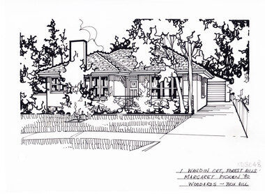
Artwork, other - Ink Line Drawing, Margaret Picken, 1 Wandin Crt., Forest Hill, 1990
A property illustration by Margaret Picken Commissioned by the real estate agency Woodards Boxhill for the purpose of advertising 1 Wandin Crt., Forest Hill built circa 1950. This property has be listed as having sold for $119,950 in 1991. Made by using Rotring ‘Rapidigraph’ drafting pens with Rotring ink on Rapidigraph polyester drafting film, double matte. Trained as a cartographic draftsman within the mining industry, Margaret Picken is an artist who worked producing property illustrations for real estate agencies in eastern suburbs of Victoria from 1983-2005. Retiring from the industry as technological changes favored coloured photography over illustrations, and commissioning companies over sole contractors.This artwork is of Historical Significance as a record of local domestic architecture.A black ink line drawing on drafters film by Margaret Picken, of 1 Wandin Crt., Forest Hill depicting a brick single story house with chimney set back from a front lawn with shrubs and trees. On the Right is a driveway leading to a separate garage. There are two hole punch holes near the centre of the left edge1 Wandin Crt., Forest Hill Margaret Picken '90 Woodards - BoxHillwhitehorse historical society, schwerkolt cottage, housing, architecture, margaret picken, house, garden, forest hill, real estate -
 Whitehorse Historical Society Inc.
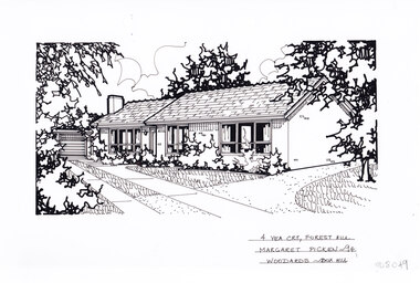
Artwork, other - Ink Line Drawing, Margaret Picken, 4 Yea Crt., Forest Hill, 1994
A property illustration by Margaret Picken Commissioned by the real estate agency Woodards Boxhill for the purpose of advertising 4 Yea Crt., Forest Hill. This property has be listed as having sold for $120,000 in 1994. Made by using Rotring ‘Rapidigraph’ drafting pens with Rotring ink on Rapidigraph polyester drafting film, double matte. Trained as a cartographic draftsman within the mining industry, Margaret Picken is an artist who worked producing property illustrations for real estate agencies in eastern suburbs of Victoria from 1983-2005. Retiring from the industry as technological changes favored coloured photography over illustrations, and commissioning companies over sole contractors.This artwork is of Historical Significance as a record of local domestic architecture.A black ink line drawing on drafters film by Margaret Picken, of 4 Yea Crt., Forest Hill depicting a brick single story house, with a driveway on the left leading to separate garage. off of the driveway are two paths, one past the front of the house and one up to the front door. There are two hole punch holes near the centre of the upper edge4 Yea Crt., Forest Hill Margaret Picken '94 Woodards - BoxHillwhitehorse historical society, schwerkolt cottage, housing, architecture, margaret picken, house, garden, forest hill, real estate -
 Whitehorse Historical Society Inc.
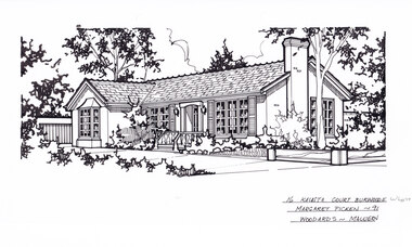
Artwork, other - Ink Line Drawing, Margaret Picken, 16 Kalista Court Burwood E, 1991
A property illustration by Margaret Picken Commissioned by the real estate agency Woodards Malvan for the purpose of advertising 16 Kalista., Burwood in 1991 Made by using Rotring ‘Rapidigraph’ drafting pens with Rotring ink on Rapidigraph polyester drafting film, double matte. This property is listed as having had unit 10 sell for $145,500 in 1991 Trained as a cartographic draftsman within the mining industry, Margaret Picken is an artist who worked producing property illustrations for real estate agencies in eastern suburbs of Victoria from 1983-2005. Retiring from the industry as technological changes favored coloured photography over illustrations, and commissioning companies over sole contractors.This artwork is of Historical Significance as a record of local domestic architecture.A black ink line drawing on drafters film by Margaret Picken, of 16 Kalista Court., Burwood East. A driveway run right to left in the foreground, with a single story L shaped brick house in the background. On the right is a front yard with a gumtree, enclosed by low timber fence. There are two hole punch holes along the top edge.16 Kalista Court., Burwood E. Margaret Picken Woodards - Malvanwhitehorse historical society, schwerkolt cottage, housing, architecture, margaret picken, burwood, house, garden, burwood esat -
 Whitehorse Historical Society Inc.
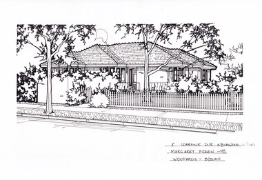
Artwork, other - Ink Line Drawing, Margaret Picken, 8 Lorraine Dve. E.Burwood, 1995
A property illustration by Margaret Picken Commissioned by the real estate agency Woodards Blackburn for the purpose of advertising 8 Lorraine Dve. Burwood East in 1995 Made by using Rotring ‘Rapidigraph’ drafting pens with Rotring ink on Rapidigraph polyester drafting film, double matte. This property is listed as having sold for $150,000 in 1995 Trained as a cartographic draftsman within the mining industry, Margaret Picken is an artist who worked producing property illustrations for real estate agencies in eastern suburbs of Victoria from 1983-2005. Retiring from the industry as technological changes favored coloured photography over illustrations, and commissioning companies over sole contractors.This artwork is of Historical Significance as a record of local domestic architecture.A black ink line drawing on drafters film by Margaret Picken, of 8 Lorraine Dve. Burwood East. One story brick house behind a front yard and picket fence. A footpath in the foreground from left to right, with a gumtree near the middle. Two hole punch holes along the top edge.8 Lorraine Dve. E.Burwood Margaret Picken -95 Woodards - B/Burnwhitehorse historical society, schwerkolt cottage, housing, architecture, margaret picken, burwood, house, garden, burwood esat -
 Whitehorse Historical Society Inc.
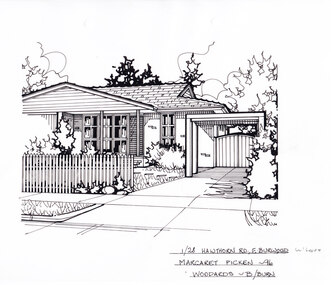
Artwork, other - Ink Line Drawing, Margaret Picken, 1/28 Hawthorn Rd., E.Burwood, 1996
A property illustration by Margaret Picken Commissioned by Woodards Blackburn real estate agency for the purpose of advertising 1/28 Hawthorn Rd., Burwood East in 1996 Made by using Rotring ‘Rapidigraph’ drafting pens with Rotring ink on Rapidigraph polyester drafting film, double matte. This property is listed as sold for $128,000 in 1996 Trained as a cartographic draftsman within the mining industry, Margaret Picken is an artist who worked producing property illustrations for real estate agencies in eastern suburbs of Victoria from 1983-2005. Retiring from the industry as technological changes favored coloured photography over illustrations, and commissioning companies over sole contractors.This artwork is of Historical Significance as a record of local domestic architecture.A black ink line drawing on drafters film by Margaret Picken, of 9 Tainton St., Burwood. A brick house with picket fence in front, and a driveway leading to a carport on the left. Two Hole punches centered near the upper edge.1/28 Hawthorn Rd., E.Burwood Margaret Picken -96 Woodards - B/Burnwhitehorse historical society, schwerkolt cottage, housing, architecture, margaret picken, burwood, house, garden, burwood east -
 Melbourne Tram Museum
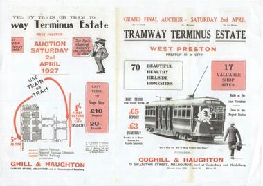
Document - Photocopy, Ron Scholten, "Tram Terminus Estate - West Preston", Original 1927
Photocopy A4 size of a foolscap document, missing left hand edge of an advertisement titled "Tram Terminus Estate - West Preston". Auction dated 2/4/1927. Has an image of tram L 104 with a destination of West Preston, 70 sites, 5 shop sites, Gilbert Road and Regent Street. Sales by Coghill and Haughton of Swanston St Melbourne Gives fares from Regent Station and by tram.trams, tramways, auctions, real estate, advertisements, new tramway, regent, west preston, tram 104 -
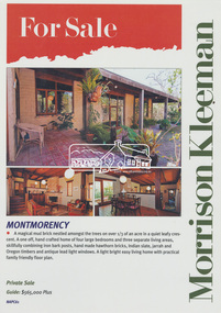 Eltham District Historical Society Inc
Advertising, Real Estate For Sale advertisement, 61 Napier Crescent, Montmorency, March 2007, 2007
Morrison Kleeman Real Estate sales information material Advertised March 2007 for $565,000 plus; Sold April 2007 for $625,000 Home of John Cust, draughtsman who worked with Robert Marshall, etcLaminated; 42.3 x 30.3 cmjohn cust, montmorency, morrison kleeman real estate, napier crescent, real estate advertisement, robert marshall -
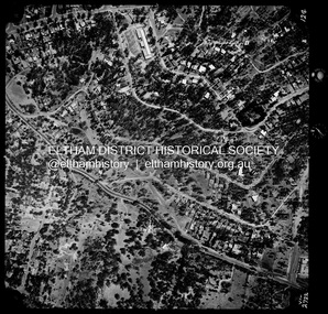 Eltham District Historical Society Inc
Photograph - Aerial Photograph, Landata, Montmorency / Lower Plenty, Jan. 1973
Centred on 385 Main Road, Lower Plenty bounded by Grand Boulevard, Montmorency to north, Old Eltham Road to south, Bolton Street to east and Panorama Avenue to west. Historic Aerial Imagery Source: Landata.vic.gov.au Aerial Photo Details: Project No :1043 Project : MONTMORENCY Run : 2 Frame : 124 Date : 01/1973 Film Type : B/W Camera : RC8 Flying Height : 2200 Scale : 4000 Film Number : 2722 GDA2020 : 37°43'48"S, 145°07'49"E MGA2020 : 335243, 5822507 (55) Melways : 21 E9 (ed. 42)aerial photo, lower plenty, main road, montmorency, phoebe mason collection, bolton steet, grand boulevard, old eltham road, panorama avenue -
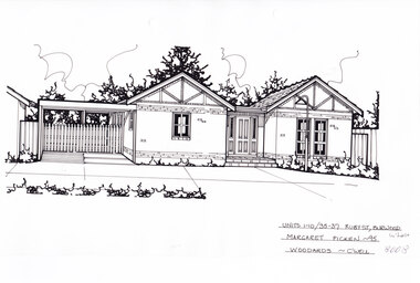 Whitehorse Historical Society Inc.
Artwork, other - Ink Line Drawing, Margaret Picken, Units 1-10/35-37 Ruby St., Burwood, 1995
A property illustration by Margaret Picken Commissioned by the real estate agency Woodards for the purpose of advertising Units 1-10/35-37 Ruby St., Burwood in 1995. Made by using Rotring ‘Rapidigraph’ drafting pens with Rotring ink on Rapidigraph polyester drafting film, double matte. This property is listed as having had unit 10 sell for $149,000 in 1995 Trained as a cartographic draftsman within the mining industry, Margaret Picken is an artist who worked producing property illustrations for real estate agencies in eastern suburbs of Victoria from 1983-2005. Retiring from the industry as technological changes favored coloured photography over illustrations, and commissioning companies over sole contractors.This artwork is of Historical Significance as a record of local domestic architecture.A black ink line drawing on drafters film by Margaret Picken, of Units 1-10/35-37 St., Burwood. a single story brick house with two pitched roofs either side of a central porch and front door. There is a connected carport on the left. There are two hole punches near the upper edge.Units 1-10/35-37 Ruby St., Burwood Margaret Picken - 95 Woodards - c'well whitehorse historical society, schwerkolt cottage, housing, architecture, margaret picken, burwood, house, garden -
Eltham District Historical Society Inc
Folder, Lois and Geoffrey Loftus-Hills
Lois Loftus-Hills (1927-2006) and her husband Geoffrey were founding members of the Australian Democrats. Lois was the editor of the national Journal. Lois was trained in the field of dietetics and when working at the CSIRO met Geoffrey. They lived at Lower Plenty and were instrumental in establishing a local Neighbourhood House. Lois was a member of EDHS. (NL-170)Folder of information on Geoffrey and Lois Loftus-Hills, Lower Plentylois loftus hills, geoffrey loftus hills -
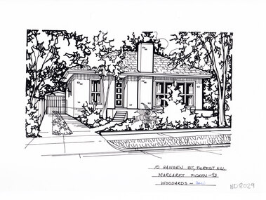 Whitehorse Historical Society Inc.
Artwork, other - Ink Line Drawing, Margaret Picken, 10 Hansen St., Forest Hill, 1993
A property illustration by Margaret Picken Commissioned by the real estate agency Woodards Blackburn for the purpose of advertising 10 Hansen St., Forest Hill This property is listed as having sold for $104,000 in 1996. Since the time of sale in 1993 the house on the property has been either rebuilt or extensively renovated. Made by using Rotring ‘Rapidigraph’ drafting pens with Rotring ink on Rapidigraph polyester drafting film, double matte. Trained as a cartographic draftsman within the mining industry, Margaret Picken is an artist who worked producing property illustrations for real estate agencies in eastern suburbs of Victoria from 1983-2005. Retiring from the industry as technological changes favored coloured photography over illustrations, and commissioning companies over sole contractors.This artwork is of Historical Significance as a record of local domestic architecture.A black ink line drawing on drafters film by Margaret Picken, of 10 Hansen St., Forest Hill, depicting a single story house with a driveway to the left and front garden. There are two hole punches near the upper edge.10 Hansen St., Forest Hill Margaret Picken - 93 Woodards - Hawwhitehorse historical society, schwerkolt cottage, housing, architecture, margaret picken, house, garden, forest hill -
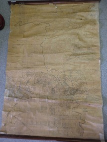 Greensborough Historical Society
Map, Map of Greensborough - Jessop's Real Estate, 1930c
This map of Greensborough hung in the office of Cec Jessop's Real Estate office corner Main and Grimshaw Street. Includes a word document listing street name changes from the original map to today, according to Norm Colvin.This map was saved from the building when the business closed.Canvas roll-up map with timber rails top and bottom.greensborough - maps, cecil jessop, greensborough street names -
 Federation University Historical Collection
Photograph - Colour, Chatham-Holmes Collection: Trawalla Estate, Victoria - Soldier Settlement
In 1917 a large part of the Trawalla estate was acquired and subdivided by the Commonwealth Government for the Soldier Settlement Scheme. Land was subdivided into 93 allotments with sizes from 250 acres to 680 acres. The land was deemed appropriate for grazing and farming.chatham-holmes collection, soldier settlement, langi kal kal, auction, philip chatham, trawalla -
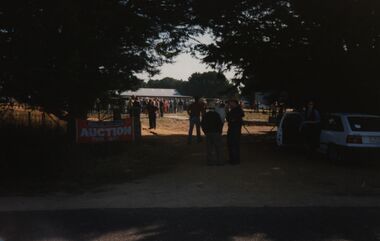
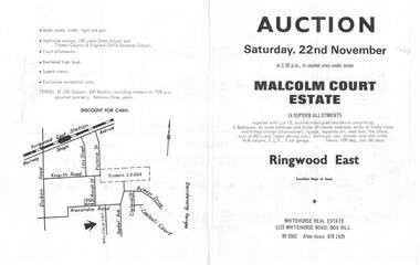 Ringwood and District Historical Society
Flyer, Land Auction Brochure, Malcolm Court Estate, Ringwood East, Vic. - 1969
Bi-folded single sheet with black print both sides advertising Auction on Saturday, 22nd November, 1969. Details include location map, vendor terms, subdivision features and local facilities. Centre page shows allotment numbers and property dimensions. Agent - Whitehorse Real Estate, 1123 Whitehorse Road, Box Hill, (Phone) 890502, After hours 8781429. Separate copy of map with handwritten sale notations for some allotments.LP 859686 -
 Eltham District Historical Society Inc
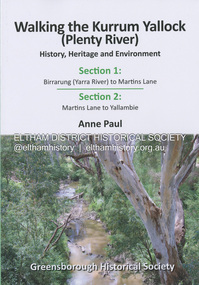
Book, Anne Paul, Walking the Kurrum Yallock (Plenty River), 25 July 2023
Kurrum Yallock - the Plenty River is Melbourne's third river. It is a defining feature of the region weaving its way through local suburbs and parklands. It is often hidden from general view, emerging at bridges and along its extensive trail network. While diminished since European settlement, the River provides an important environmental, wildlife corridor and recreational resource, along with many links to its settlement heritage. The Kurrum Yallock walks aim to guide people along the River Trail, while providing insight into key aspects of our recent history, an opportunity for reflection and an enhanced enjoyment of the River's special environment and landscape.birrarung, greensborough historical society, kurrum yallock, martins lane, plenty river, yallambie, yarra river -
 Eltham District Historical Society Inc
Photograph - Aerial Photograph, Landata, Lower Plenty, Feb. 1956
Centred on present day 217 Old Eltham Road, Lower Plenty bounded by Pitt Street to north, Yarra River to south, Main Road to east and Bonds Road to west. Historic Aerial Imagery Source: Landata.vic.gov.au Aerial Photo Details: Project No :250 Project : MELBOURNE OUTER SUBURBS PROJECT Run : 17 Frame : 116 Date : 02/1956 Film Type : B/W Camera : EAG9 Flying Height : 10000 Scale : 12000 Film Number : 1176 GDA2020 : 37°43'58"S, 145°07'49"E MGA2020 : 335237, 5822186 (55) Melways : 21 E10 (ed. 42)aerial photo, 1956-02, neil webster collection, eltham, main road, bonds road, elham, lower plenty, melway 21e10, pitt street, yarra river -
 Eltham District Historical Society Inc
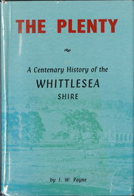
Book, J. W. Payne, The Plenty: A Centenary History of the Whittlesea Shire, 1975
This book traces the one hundered years of the development of the Shire of Whittlesea, from the discovery by Hume and Hovell in 1824 to the time of the centenary in 1975. The intervening years saw the settlement of Vandemonians, Sydney-siders, English, Scots, Irish and Germans, Black Thursday, the building of the Yan Yean Reservoir, the Plenty River flour millls, the timber industry, fruit-growing and export and vineyards. Personalities and pubs, subdivisions, stories of the Findon Hunt Club and various Shires including Epping. History of education and transiton from rural to urban in the south of the Shire. The work is illustrated with maps and photographs. The Shire is now the City of Whittlesea and is an immediate neighbour to the north of the Shire of Nillumbik. shire of whittlesea -
 Eltham District Historical Society Inc
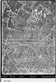
Photograph - Aerial Photograph, Landata, Montmorency / Lower Plenty, 28 Jan. 1946
Centred on 32 Grand Boulevard, Montmorency bounded by Rattray Road to north, Main Road, Lower Plenty to south, Bolton Street to east and Looker Road to west. Historic Aerial Imagery Source: Landata.vic.gov.au Aerial Photo Details: Project No :5 Project : MELBOURNE AND METROPOLITAN AREA PROJECT Run : 34 Frame : 61778 Date : 12/1945 (28.1.46) Film Type : B/W Camera : EAG4 Flying Height : 10200 Scale : 6000 Film Number : 212 GDA2020 : 37°43'30"S, 145°07'37"E MGA2020 : 334934, 5823043 (55) Melways : 21 E8 (ed. 42)aerial photo, bolton steet, looker road, lower plenty, main road, montmorency, phoebe mason collection, rattray road -
 Eltham District Historical Society Inc
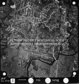
Photograph - Aerial Photograph, Landata, Montmorency / Lower Plenty, Jan. 1962
Centred on 147 Old Eltham Road, Lower Plenty bounded by Hurstbridge Railway Line to north, Yarra River to south, Main Road, Eltham to east and Heidelberg Golf Club to west. Historic Aerial Imagery Source: Landata.vic.gov.au Aerial Photo Details: Project No : 539 Project : MELBOURNE-GEELONG PROJECT Run : 6 Frame : 81 Date : 01/1962 Film Type : B/W Camera : RC5 Flying Height : 6000 Scale : 15840 Film Number : 1524 GDA2020 : 37°43'52"S, 145°07'26"E MGA2020 : 334685, 5822354 (55) Melways : 21 D9 (ed. 42)aerial photo, lower plenty, main road, montmorency, phoebe mason collection, eltham, eltham lower park, heidelberg golf club, hurstbridge railway line, main road eltham, yarra river -
 Eltham District Historical Society Inc
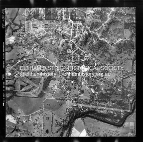
Photograph - Aerial Photograph, Landata, Montmorency / Lower Plenty, Feb. 1956
Centred on 20 Panorama Avenue, Lower Plenty bounded by Rattray Road to north, Yarra River to south, Bolton Street to east and Heidelberg Golf Club to west. Historic Aerial Imagery Source: Landata.vic.gov.au Aerial Photo Details: Project No : 250 Project : MELBOURNE OUTER SUBURBS PROJECT Run : 16A Frame : 53 Date : 02/1956 Film Type : B/W Camera : EAG9 Flying Height : 10000 Scale : 12000 Film Number : 1187 GDA2020 : 37°43'47"S, 145°07'25"E MGA2020 : 334645, 5822519 (55) Melways : 21 D9 (ed. 42)aerial photo, lower plenty, main road, montmorency, phoebe mason collection, bolton steet, heidelberg golf club, rattray road -
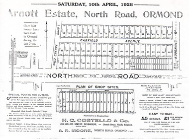 City of Moorabbin Historical Society (Operating the Box Cottage Museum)
Flyer - Arnott Estate, North Road, Ormond
At the end of World War One, there was a renewed interest in residential land and a number of estates opened up in the Municipality of Moorabbin.Example of the progress of the Municipality of MoorabbinPhotocopy of Advertising flyer for auction of real estate sales - plan of building blocks for saleArnott Estate, North Road, Ormond. Auction Satire 10 April 1926 - 42 home sites & 20 shop sitesnorth road, ormond, real estate, auctions, garfield avenue -
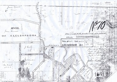 Greensborough Historical Society
Plan, Parish Plan Map of Land North of Grimshaw Street, 11/12/1879
Part of Parish plan of land north of Grimshaw Street bounded by the Plenty River. Includes annotation signed by John Scotland and J. W. Britnell, dated Dec. 11th 1879.Photocopy of part of Parish plan of land north of Grimshaw Street bounded by the Plenty River. Includes annotation signed by John Scotland and J. W. Britnell, dated Dec. 11th 1879greensborough, grimshaw street greensborough, jonah britnell, john scotland -
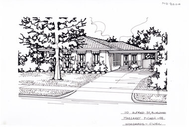 Whitehorse Historical Society Inc.
Artwork, other - Ink Line Drawing, 10 Alfred St., Burwood, 1999
A property illustration by Margaret Picken Commissioned by the real estate agency Woodards, Camberwell for the purpose of advertising 10 Alfred St., Burwood for sale in 1999. Made by using Rotring ‘Rapidigraph’ drafting pens with Rotring ink on Rapidigraph polyester drafting film, double matte. The suburb lines are believed to have been redrawn, making this property no longer in Burwood, but located in Glen iris. This property is listed as having sold for in 1999 for $380,000 Trained as a cartographic draftsman within the mining industry, Margaret Picken is an artist who worked producing property illustrations for real estate agencies in eastern suburbs of Victoria from 1983-2005. Retiring from the industry as technological changes favoured coloured photography over illustrations, and commissioning companies over sole contractors.This artwork is of Historical Significance as a record of local domestic architecture.A Black ink line drawing on drafters film by Maragret Picken, of 10 Alfred St., Burwood. Depicted is a one-story brick house situated back from a front lawn with a large tree, and a driveway on the right, leading to a connected carport. There to two hole punches just below the upper edge, and a approximately 1cmx1cm tape reside mark left of centre near the bottom edge 10 Alfred St., Burwood Maragret Picken - 99 Woodards - c'wellwhitehorse historical society, schwerkolt cottage, housing, architecture, margaret picken, burwood, glen iris, house, garden