Showing 3069 items matching "scales"
-
 Ithacan Historical Society
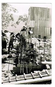
Photograph, Earthquakes: Rebuilding the Church of Taxiarchion, Ithaca, 1953
The Taxiarches church, located on top of Monastery Hill overlooking the village of Platrithia, was being rebuilt followingits total destruction caused by the earthquake across the Ionian Islands in 1953. The earthquake which reached 7.2 on the Richter Scale totally destroyed many towns and villages. A committee was formed to rebuild the church which is now considered to be one of the most beautiful churches on Ithaca.A black and white photograph of workmen rebuilding a damaged structure. Upright steel rods have been placed along the foundations for the outer walls and seven men are pouring concrete into the reenforced trenches.A stamp which has been written in Greek is on the back of the photograph. Translated it reads as follows:REBUILDING COMMITTEE/HOLY CHURCH OF TAXIARCHES/PLATRITHIA - ITHACA -
 Flagstaff Hill Maritime Museum and Village
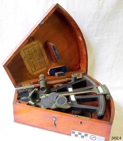
Instrument - Octant, mid 1800's
An Octant is a doubly reflecting navigation instrument used primarily by sailors to measure the angular distance between two visible objects and was a forerunner of the sextant. The name comes from the Latin octo, or "one-eighth of a circle," for the Octan'ts arc which spans 45°, or one-eighth of a circle. The primary use of an Octant is to measure the angle between an astronomical object and the horizon for celestial navigation. The estimation of this angle, is known as sighting or shooting the object, or taking a sight. The angle, and the time when it was measured, can be used to calculate a position line on a nautical chart (latitude), for example, sighting the Sun at noon or Polaris at night (in the Northern Hemisphere) gives an angle by which the latitude can then be estimated. Sighting the height of a landmark on land can also give a measure of distance. This fine octant once belonged to Captain Farquhar Chisholm and was donated by his granddaughter, Margaret Ruth Greer (nee Chisholm, born 1914). The label inside the Octant's box reads “Thomas L. Ainsley, Instrument Maker … etc”. Farquhar Chisholm was born in 1832 in Inverness, Scotland. He regularly sailed on perilous voyages between Quebec, Canada and the Baltic ports of Europe. In 1854 he migrated to Australia during the Gold Rush, to a place called Fiery Creek (near Beaufort Victoria) where he was fairly successful in his quest for gold. In the years of the Great Gold Rush, it was said that there were over 40,000 diggers in the goldfields of the Beaufort area! In 1857 having made sufficient money, he hired another crew and returned to Clachnacuddin, Inverness shire, Scotland and in that same year, he studied and obtained his Master Mariner Certificate (which would have included the use of an octant for navigation). He was appointed to Mr George (or James) Walker, as commander of his sailing ship, the 3-masted ELIZABETH, built 1859 and known as “The Walker barque”. In 1870 he married, then in 1887 returned to Australia with his wife and children (Kenneth Chisholm (1871), Mary Bremner Chisholm (1873), Margaret Hood Chisholm (1874), Farquhar Chisholm (1878)). They arrived in Port Melbourne, Victoria and sadly, only six weeks after landing, his wife Caroline passed away (in Geelong,1888). In 1900 Capt. Chisholm lived in Camperdown (Victoria) and not long after this his daughter Margaret died of consumption. In his later years, he went to live in the manse of St. Paul’s Presbyterian Church, Wangaratta, with his son, Rev. Farquhar Chisholm. He died there on Sat, 23rd March 1912, 80 years old. He was known as “… quiet, unobtrusive and competent, respected by all with whom he came in contact”. Some other members of Captain Chisholm’s family are; his older son Kenneth Chisholm, who was a contractor in Camperdown; a nephew Donald Macintosh (of 23 Douglas Row, Inverness); a grandson Brian Jones (son of Caroline Belle-Jones nee Chisholm, who lived in Camperdown in the earlier part of her life).The octant, the forerunner of the sextant, was a significant step in providing accuracy of a sailors latitude position at sea & his vessels distance from land when taking sightings of land-based landmarks.Octant, once belonging to Captain Farquhar Chisholm. Wedge shape (the size of an eighth of a circle), made of wood, glass and metal. Used in the 1880s. Maker’s name across centre “L. SIMON - - - SHIELDS”. Three (3) light filtering, coloured glass shades. Two (2) eyepieces. Scale attached for measuring angles. Label inside the fitted, wedge-shaped case "Thomas L. Ainsley, Optician"Label inside case "Thomas L. Ainsley, Optician" Maker’s name across centre “L. SIMON - - - SHIELDS”.flagstaff hill, warrnambool, shipwrecked-coast, flagstaff-hill, flagstaff-hill-maritime-museum, maritime-museum, shipwreck-coast, flagstaff-hill-maritime-village, maritime navigation, navigation instrument, migration, captain chisholm, farquhar chisholm, sailing ship, the elizabeths, thomas l. ainsley, l. simons, shields england, octant, john hadley, chisholm -
 Montmorency–Eltham RSL Sub Branch
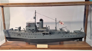
Unknown - Scale model HMAS Maryborough (1)
Model of the ship served on by W Thomson during WWII.Scale model of the HMAS Maryborough that was operated by the Australian Navy during WWII.Grey and black painted plastic and wood scale model of the Bathurst class HMAS Maryborough (1940 to 1946) minesweeper (commonly known as corvettes) mounted in a wooden frame glass sided and top case. It has cotton rigging with metal anchor chains. An inscribed metal plate is located on the front glass side. The upper of the model is painted grey, and the bottom black. J195 is painted in black lettering on the bow of the model.J195 H.M.A.S Maryborough 1940 - 1946 Made by W. Thomsonmodel, hmas maryborough, bathurst class, minesweeper, corvette -
 Warrnambool and District Historical Society Inc.
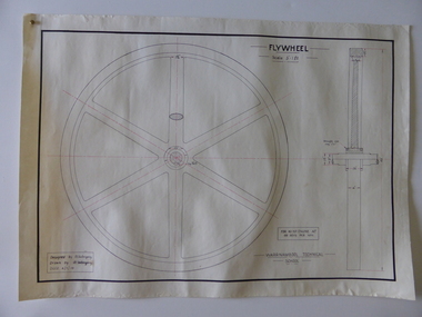
Drawing, Warrnambool Tech .1 Fly Wheel.2 Bevel Wheels R Uebergang, 1919
These drawings have been produced by Ron Uebergang at the Warrnambool Technical School in 1919. Uebergang family members were pioneer settlers in the Warrnambool area in the early 1850s. Ronald John Uebergang (1903-1971) was born in Warrnambool to Ernest Uebergang and Mary Watson. Ron Uebergang lived at the family property, Hopkins Hill at Allansford and went to Allansford State School and Warrnambool Technical School. He was mechanically minded, a good photographer and fond of music and dancing. He married Myra Hall and was a dairy farmer at Hopkins Hill and later grazed beef cattle. Warrnambool Technical School was established in 1913, firstly at a Timor Street site and later at Caramut Road (today it is known as Brauer College). These drawing are of considerable interest as works produced by Ron Uebergang. Uebergang family members have been prominent in the Warrnambool-Allansford area since the pioneering days of the district. The drawings also are good examples of the type of work produced by Warrnambool Technical School students in its early years.These are two designs and drawings by Ron Uebergang produced at the Warrnambool Technical School in 1919. They are drawn on white card using black and red ink. The scale of the Flywheel is three inches to one foot and the Bevel Wheels are one-third full size. The drawings are edged with heavy black lines. The two sheets have the signature of Ron Uebergang. There are also four pages of handwritten notes on the Flywheel and Bevel Wheels.‘Designed by R. Uebergang’ ‘Drawn by R.Uebergang’ ‘Date 4/1/19’ (on Flywheel sheet) ‘Date 27/5/19’ (on Bevel Wheels sheet) warrnambool technical school, ronald uebergang, history of allansford -
 Bendigo Historical Society Inc.
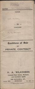
Document - H.A. & S.R. WILKINSON COLLECTION: CONTRACT OF SALE
Conditions of sale by private contract dated 1st February, 1944 between D.B. Julyan (seller) and J.E. Salter (buyer) for that fruit and confectionary business situate 175 View Street, Bendigo, together with the goodwill, stock fittings Salter Spring balance scales, all shelving and ''Westinghouse'' Frigidaire as inspected by the purchaser and everything connected with said business in the shop and which belongs to the vendor. Price 300 pounds.organization, business, h.a. & s.r wilkinson real estate -
 Bendigo Historical Society Inc.
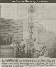
Newspaper - JENNY FOLEY COLLECTION: HOLLAND FOUNDRY
Bendigo Advertiser ''The way we were'' from 2000. Holland foundry: this photo taken in 1900 of the Holland foundry, 205 King Street. From left to right: Ern Holland, Mr. Flourdale, Perce Holland, Herb Holland, Rupert Holland and seated is Walter John Holland. This model of water pump for working in a mine shaft to a depth of 1100 feet. These workings are on a scale of one to eight. The clip is in a folder.newspaper, bendigo advertiser, the way we were -
 Bendigo Historical Society Inc.
Map - STATE RIVERS AND WATER SUPPLY COMMISSION : COLIBAN DISTRICT MAP 1956, 30/11/1956
State Rivers and Water Supply Commission Coliban District map. Titled: S.R. & W.S.C. Coliban District Plan showing Irrigation and Town Supply Channels 1956. Scale: 1 inch = 4 miles. Indicates concrete lining and concrete re-lining channels. Printed in blue ink and information added in red. The map is dated at the bottom - 30/11/'56. There is a number, 25,491, in the bottom right corner.state infrastructure, water supply, coliban system, state rivers and water supply commission. coliban system. -
 Bendigo Historical Society Inc.
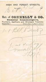
Document - PEARCE COLLECTION: INVOICES FROM CONNELLY & CO
Collection of invoices from Connelly & Co - Wholesale Ironmongers, Plumbers, Gas fitters, Bell Hangers; High and Forest Streets. The invoices are all address to Eldridge & Burnett. Some invoices have a grey scale photo of the Connelly & Co Building on the corner of High and Forest Streets. A green 1d Victoria Stamp Duty Stamp appears on a couple of the invoices. Note the phone is No 7. The invoices are dated for the year 1909.business, retail, bendigo -
 Bendigo Historical Society Inc.
Map - CAMPBELL COLLECTION: BENDIGO AND DISTRICT MAPS
Map. Eppalock, Sedgwick and Strathfieldsaye, scale 20 chains to 1 inch. Road to Bendigo 13 1/2 miles at top right of map, Longlea Railway Station 5 1/2 miles, Bendigo 11 miles, Strathfieldsaye 5 miles on left of map. Total area 3972 acres. Prepared in W.P.B. from Assessment Plan and Parish Plans. H.A. Darby 14-6-29.H.A.Darbymap, bendigo, agricultural lands -
 Bendigo Historical Society Inc.
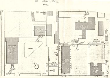
Document - PLAN OF THE AREA SURROUNDING: ST. KILIAN'S CHURCH
Plan of area surrounding St. Kilian's Church showing location of church, Bishop's Palace, and Vault, position of the Bell,. St. Kilians Girls School, St. Kilians Hall and the Catholic Ladies Club building. Plan is over stamped in a number of places with ''H.C. Application No 765'' and appears to have spot heights and indication of slope in two places (''I in 60''). No indication on plan of scale of plan. No date.church, history, st. kilian's catholic church, bendigo, bishops palace, ladies club building, st kilian's hall. -
Clunes Museum
Map - MAPS
MINING IN CLUNES.1 THE PORT PHILLIP & COLONIAL GOLD MINING CO. CLUNES. NORTH CROSS SECTION AND SOUTH CROSS SECTION. SCALE 1:100 .2 NEW NORTH CLUNES SHEET 2. TRANSVERSE SECTIONS AND LONGITUDINAL SECTIONS. 656. LOOKING SOUTH. LOOKING NORTH .3 TRANSVERSE SECTIONS, SOUTH CLUNES UNITED G.M. CO. No.1 SHAFT, No.2 SHAFT, No.3 SHAFT, No.4 SHAFT..1 ON BACK OF MAP: NORTH PORT PHILLIP X-SECTION 22325N .2 HANDWRITTEN NOTES ON MAP .3 HANDWRITTEN NOTES ON MAPport phillip & colonial gold mining, new north clunes, south clunes united -
 Whitehorse Historical Society Inc.
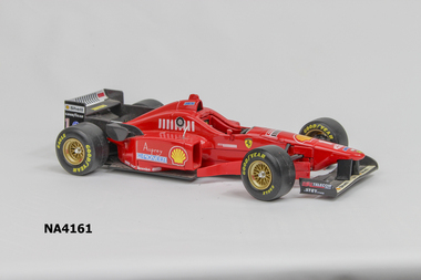
Leisure object - Toy Car, 1996
Car belonged to Michael Smith, grandson of Society member Valda Arrowsmith. Always dreamed of owning a Ferrari, so at about aged 15 he purchased this model (1996)Red model Ferrari racing car. Four rubber tyres with Eagle Good Year stamped on each. Wheels have gold spokes and rims. Each side has 'Asprey Pioneer Arexons SKF brembo BBS & the Shell sign printed on it.The driving seat has seat belt, steering wheel and windscreen. Base Ferra. F310 (1996) Scale 1/20 Maisto ShellAsprey Pioneer Shell / Good Year / Schumachertoys, mechanical, transport, models -
 Bendigo Historical Society Inc.
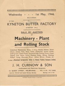
Document - IAN DYETT COLLECTION: KYNETON BRANCH FACTORY AUCTION CATALOGUE
Two J. H. Curnow & Son Auction catalogues for a sale by auction of Machinery - Plant and Rolling Stock by order of Newstead Co-Operative Butter & Cheese Factory Company Limited. Conditions of Sale and J. H. Curnow & Son, Auctioneers is printed inside the front cover. The sixty one items include belting, scales, electric motor, shafting, pumps, tanks, vats, boiler, piping and vehicles.business, retail, j h curnow & son, ian dyett collection - kyneton branch factory auction catalogue 1/5/1946, newstead co-operative butter & cheese factory company limited, j h curnow & son, the prahran telegraph printing co -
 Bacchus Marsh & District Historical Society
Map, Plan of land purchased by the Bacchus Marsh Shire Council from Mr. T. Low for a deviation of the Melbourne to Ballarat main road. 1877
The date of this plan is 1877 and the land indicted on it required for a road deviation is shaded in blue. It adjoins the Korkuperrimul Creek on one side which indicates the land is located just a few kilometers to the west of Bacchus Marsh. Single page map showing a portion of land purchased by the Bacchus Marsh Shire from Mr Thomas Low for the purpose of a road deviation. Land held by David Robertson is also shown on the map. Scale: 2 chains to 1 inch. Part of a set of maps which are pasted into a bound volume containing 76 maps or plans in total. High resolution digital image stored on BMDHS computer network. Surveyed by W. E. Standfield, Shire Engineer, Bacchus Marsh, 12/4/77bacchus marsh roads and streets, melbourne to ballarat road -
 Bendigo Historical Society Inc.
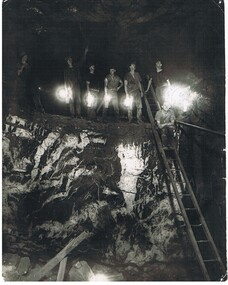
Photograph - HERCULES AND ENERGETIC MINE, 1939
black and white photo of underground mining, showing 8 miners in a stope with their Bendigo bucket carbide lights. A large quartz spur formation is visible in the foreground. A wooden ladder gives a good scale in relation to the stope size. Photograph taken in the Central Nell Gwynne at the 265 m. level C 1939. On back MNc4 ( in indian ink ) ? Hercules and Energetic ( in ball point pen ) RHSV of Vic. Stamp.organization, business, hercules and energetic mine -
 Bendigo Historical Society Inc.
Document - BEEBE, BAPTIST CHURCH DRAWING
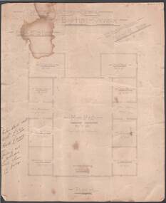
Parchment paper architect drawing by William Beebe. Printed heading, 'Proposed Sunday School, Baptist Church', dated 21/9/ 05. Scale 8 feet to Inch. Eight rooms surrounding 30 feet x 50 feet main hall lighted by clearstory. Handwritten cost estimated if weatherboard £850, brick £1040, fencing not included. Land & house 72-foot frontage. Unknown donorbendigo, churches, baptist, beebe -
University of Melbourne, Burnley Campus Archives
Plan, The Museum of Modern Art at Heide, 1995
(1) Photocopy of Herb and Plant Location Map, Heide Kitchen Garden, plants numbered, no legend. (2) 1 tracing paper, 1 paper and 1 paper reduced size, Sketch Plan. Scale 1:1000. Drawn by JK (Jill Kellow, Staff) 06.06.1995. (3) Photocopy of Heide Park and Art Gallery Grounds and Planting. Numbered Plant List, 1 Trees, 2 Shrubs.heide, museum of modern art, gardens, jill kellow, bulleen, kitchen garden -
 Melbourne Tram Museum
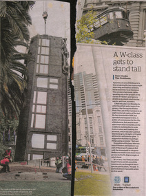
Newspaper, The Age, "A W class gets to stand tall", Nov. 2013
Newspaper clippings from The Age, Nov 2013, titled "A W class gets to stand tall" about the positioning of full scale model of W7 1040, at the corner of Spencer and Flinders St. Item details the Art project, sponsored by the City of Melbourne and undertaken by David Bell and his team. Consists of two pieces of newspaper, not known how they went together. See also Reg Item 499trams, tramways, melbourne, sculpture, art works, flinders st, spencer st -
 Bendigo Historical Society Inc.
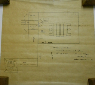
Plan - MARKS COLLECTION: PLAN NEW BOILER LANSELL'S LITTLE 180 MINE
Plan drawn on buff coloured waxed paper. Written on bottom: 'No. 1 Arrangement New Boiler for Lansells Proprietary Little 180 Mine Bendigo. Scale 1/4 inch = 1 foot. Hargraves & Daggar, Consulting Engineers, Victoria Chambers Bendigo' Plan shows entry of tramway, fuel store, boiler room, stack (75 ft), driving platform, winding engine, view to shaft.mining, lansell's little 180 mine, george lansell, gold mining, bendigo -
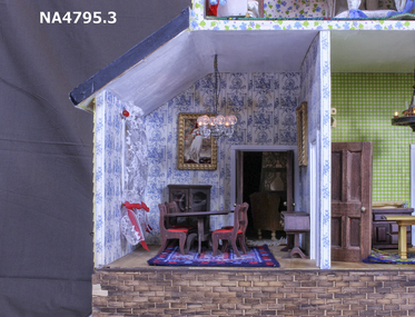
 Whitehorse Historical Society Inc.
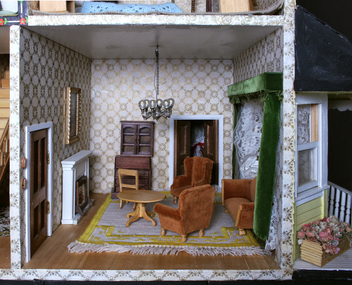
Mixed media - Doll House, Yvonne Fitzmaurice, Doll House Sitting Room - contents, 1976 - 1978
Handmade and imported furniture for doll's house made by Yvonne Fitzmaurice for the daughter, Susan, on her birthday.Hand-made child's doll's house. Built by Mrs Yvonne Fitzmaurice and finished in 1979. This house was built as a 1:12 scale and is a model of a Californian house called Peppercorn farm. House was built by Yvonne and her family and took a period of three years. A lot of the furniture is handmade and the rest is collected from various shops. Catalogued books, manuals, repair kits etc used when building the house.house, dolls, tongue depressors -
 Whitehorse Historical Society Inc.
Mixed media - Doll House, Yvonne Fitzmaurice, Doll House Dining Room - contents, 1976-1978
Hand-made child's doll's house. Built by Mrs Yvonne Fitzmaurice and finished in 1979. This house was built as a 1:12 scale and is a model of a Californian house called Peppercorn farm. House was built by Yvonne and her family and took a period of three years. A lot of the furniture is handmade and the rest is collected from various shops. Catalogued books, manuals, repair kits etc used when building the house. house, dolls -
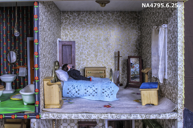 Whitehorse Historical Society Inc.
Mixed media - Doll House, Yvonne Fitzmaurice, Doll House Front Bedroom -contents, 1974
Hand-made child's doll's house. Built by Mrs Yvonne Fitzmaurice and finished in 1979. This house was built as a 1:12 scale and is a model of a Californian house called Peppercorn farm. House was built by Yvonne and her family and took a period of three years. A lot of the furniture is handmade and the rest is collected from various shops. Catalogued books, manuals, repair kits etc used when building the house.house, dolls -
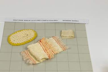 Whitehorse Historical Society Inc.
Mixed media - Doll House, Yvonne Fitzmaurice, Doll House Bathroom - contents, 1974
Hand-made child's doll's house. Built by Mrs Yvonne Fitzmaurice and finished in 1979. This house was built as a 1:12 scale and is a model of a Californian house called Peppercorn farm. House was built by Yvonne and her family and took a period of three years. A lot of the furniture is handmade and the rest is collected from various shops. Catalogued books, manuals, repair kits etc used when building the house.house, dolls -
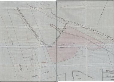 Bendigo Historical Society Inc.
Plan - MCCOLL, RANKIN AND STANISTREET COLLECTION: PLAN OF MONUMENT HILL BATTERY
Pale blue waxed paper plan. Written on back of plan ' Monument Hill Battery site, area desired by Bendigo Mines (Nell Gwynne) for disposal of mullock. Plan shows Ophir Street, Rowan Street, Written on bottom RH corner 'Bendigo Mines Ltd., surface plan, vicinity Nell Gwynne Shaft, Scale 1" = 40' Magnetic north marked, sand dumps and contour lines.bendigo, business, mccoll, rankin & stanistreet -
 Eltham District Historical Society Inc
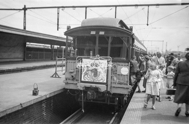
Photograph, George Coop, The Royal Train, on display at Spencer Street Railway Station during the 1954 Victorian Railways Centenary Exhibition, Sep. 1954
"V.R. Cavalcade" Centenary 1854-1954 Exhibition (11-25 Sep 1954) presented a model railway occupying about 1,400 square feet in the Lower Town Hall featuring a number of model railway working scale models. The exhibition also included a display of rolling stock, track, electrical and other railway equipment held at Spencer Street Railway Station.Digital TIFF file Scan of Kopdak 620 black and white negative transparencygeorge coop collection, royal train, display, spencer street railway station, v.r. cavalcade, victorian railways centenary 1854-1954 exhibition -
 Eltham District Historical Society Inc
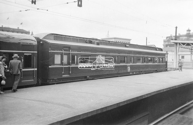
Photograph, George Coop, The Royal Train, on display at Spencer Street Railway Station during the 1954 Victorian Railways Centenary Exhibition, Sep. 1954
"V.R. Cavalcade" Centenary 1854-1954 Exhibition (11-25 Sep 1954) presented a model railway occupying about 1,400 square feet in the Lower Town Hall featuring a number of model railway working scale models. The exhibition also included a display of rolling stock, track, electrical and other railway equipment held at Spencer Street Railway Station.Digital TIFF file Scan of Kopdak 620 black and white negative transparencygeorge coop collection, royal train, display, spencer street railway station, v.r. cavalcade, victorian railways centenary 1854-1954 exhibition -
 Eltham District Historical Society Inc
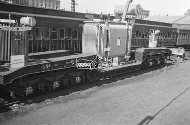
Photograph, George Coop, Power transformer on a QB boiler/flat wagon on display at Spencer Street Railway Station during the 1954 Victorian Railways Centenary Exhibition, Sep. 1954
"V.R. Cavalcade" Centenary 1854-1954 Exhibition (11-25 Sep 1954) presented a model railway occupying about 1,400 square feet in the Lower Town Hall featuring a number of model railway working scale models. The exhibition also included a display of rolling stock, track, electrical and other railway equipment held at Spencer Street Railway Station.Digital TIFF file Scan of Kopdak 620 black and white negative transparencygeorge coop collection, display, spencer street railway station, v.r. cavalcade, victorian railways centenary 1854-1954 exhibition, power transformer, qb boiler/flat wagon, qb-13 -
 Eltham District Historical Society Inc
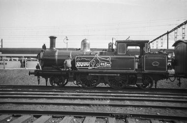
Photograph, George Coop, Steam locomotive E-class 2-4-2 on display at Spencer Street Railway Station during the 1954 Victorian Railways Centenary Exhibition, Sep. 1954
"V.R. Cavalcade" Centenary 1854-1954 Exhibition (11-25 Sep 1954) presented a model railway occupying about 1,400 square feet in the Lower Town Hall featuring a number of model railway working scale models. The exhibition also included a display of rolling stock, track, electrical and other railway equipment held at Spencer Street Railway Station.Digital TIFF file Scan of Kopdak 620 black and white negative transparencygeorge coop collection, display, spencer street railway station, v.r. cavalcade, victorian railways centenary 1854-1954 exhibition, e-class steam locomotive -
 Greensborough Historical Society
Map, Heidelberg: Historic River Landscape Assessment. Historical maps. Map E 1901-1934 "A Time of projects and improvements", 1985c
Geographical area of around 35 sq. kilometres marked with physical features such as major roads, railways (new extension to Eltham), rivers and properties, also housing sub-divisions and community facilities such as hospitals, parks and sporting reserves and indications of new small scale industries such as dairying. Bounded by Shire of Diamond Valley to the North, Darebin Creek to the West and Plenty River to the East. Black and white sketch map on white paperheidelberg, heidelberg - maps -
4th/19th Prince of Wales's Light Horse Regiment Unit History Room
Booklet, Ramsay, Ware Publishing Pty Ltd, Tropical Warfare (Aust) Pamphlet No 1 1944, 1944
The booklet acknowledged that the Army would have to face an enemy capable of being armed and equipped on a scale equal to our own and setting out conditions likely to be met and the methods used to apply the principles of war in a tropical environment. This information, published in 1944, may have been useful for Australian troops and their planners when they had to deal with the Japanese some 2 years earlier. Soft covered booklet Cancels MPT (Aust) No 23 xx Jungle Warfareworld war 2, australian tactics,