Showing 4562 items matching "the avenue"
-
 Chelsea & District Historical Society Inc
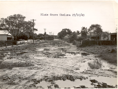
Photograph - Elsie Grove, Chelsea, 1949
This photo is one of a collection of photos taken during Alan Niemann's - Drainage-Road Making Scheme. Elsie Grove runs between Station Street and Randal Avenue, Chelsea.Black and white photo looking east along Elsie Grove, Chelsea. The road is unmade and rutted with large puddles, houses line both sides and electricity poles are on the left side of the road. The photo has been taken from Station Street.unmade street, aspendale, alan niemann, drainage-road making scheme, elsie grove -
 Eltham District Historical Society Inc
Document - Folder, Yarra Glen, 2006
eltham shire council, harry gilham collection, yarra flats, yarra glen, welcome home committee, batt's hotel, brock, charles wingrove, christmas hills, eltham-yarra glen road, kilpatrick, memorial, monument, progress league, victoria hall -
 Kew Historical Society Inc
Plan - Subdivision Plan, Houghton Street & Buchanan Avenue, Balwyn North, ca. 1906
The Kew Historical Society collection includes almost 100 subdivision plans pertaining to suburbs of the City of Melbourne. Most of these are of Kew, Kew East or Studley Park, although a smaller number are plans of Camberwell, Deepdene, Balwyn and Hawthorn. It is believed that the majority of the plans were gifted to the Society by persons connected with the real estate firm - J. R. Mathers and McMillan, 136 Cotham Road, Kew. The Plans in the collection are rarely in pristine form, being working plans on which the agent would write notes and record lots sold and the prices of these. The subdivision plans are historically significant examples of the growth of urban Melbourne from the beginning of the 20th Century up until the 1980s. A number of the plans are double-sided and often include a photograph on the reverse. A number of the latter are by noted photographers such as J.E. Barnes.A hand-drawn subdivision plan listing six blocks bounded by Houghton Street, Doncaster Road, Buchanan Avenue and Maud Street, North Balwyn. Written on the plan of subdivision are the lot numbers, the dimensions of the blocks and the price at which two lots were for sale or had been sold for.subdivision plans - balwyn -
 Bendigo Historical Society Inc.
Photograph - Bendigo Telephone Exchange, three photographs. circa 1912
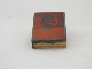
Bendigo telephone and postal exchange staff circa 1912Bendigo Telephone Exchange & Postal Staff, three photographs circa, 1912. Three B&W photographs of the staff of the Bendigo Telephone Exchange. Date stamped on rear of mounts as 2 Dec 1912. Pl return to B M Callinan, 15 Kendari Avenue 3104, 8595199Photographer - W. H. Robinson, Bendigo bendigo telephone and postal exchange staff circa 1912 -
 University of Melbourne, Burnley Campus Archives
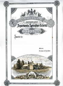
Certificate - Diploma Certificate, Ruth Waters et al, Royal Horticultural School, Burnley Diploma circa 1891- unused and Pavillion Print, c. 1891
1. 18 unused coloured Diploma Certificates of the type used in c. 1891. Royal Horticultural School Burnley Department of Agriculture, Victoria. 2. Includes a drawing, a copy of the coloured areas of the 'Pavillion Print' made by Ruth Waters, 2 Jackson Avenue, Box Hill, in 1991. diploma, certificate, pavillion print, ruth waters, original diploma certificate, drawing -
 Victorian Interpretive Projects Inc.
Photograph - Colour, Clare Gervasoni, Koroit War Memorial, 2015, 25/12/2015
The bulk of World War One soldiers from Koroit were Protestant. It was a traumatic and divisive time for the Koroit Community based on religion, which was put behind them after the conclusion of the war. The Koroit War Memorial was not built until 1928. HONOR AVENUE AT KOROIT. Last year one side of Albert-street, Koroit was planted with plane trees, with strong guards, in honor of the men who had gone to the front from Koroit and district. The trees were planted rather late in the season, but fortunately there were only two failures, and the remainder are now higher than the guards. This year, the committee appointed decided to do the work earlier, and the King's birthday was set apart for it. On Saturday afternoon, states our correspondent; a lot of the preliminary work was done and on Monday some 30 residents assembled and went to work and by tea time the whole of the 52 trees and the guards were finished. There are 52 trees on each side of the street planted at intervals of 15 yards so that the avenue is about 800 yards long, running from the Botanical Gardens to the Lake Bank, and in a few years, when the trees are well grown, there will the a magnificent avenue. The weather was beautiful, and during the afternoon number of ladies were present. The ladies brought baskets of good things, and afternoon tea was provided at Mr. W. J. Stevenson's residence, which is situated about mid-way in the avenue. A suggestion has been made that the name of the street should be changed to "Anzac Avenue."' (Warrnambool Standard, 6 June 1918.) The Koroit War Memorial on the edge of the Koroit Botanical Gardens.world war one, world war two, world war, koroit, koroit war memorial, koroit botanical gardens, cenotaph -
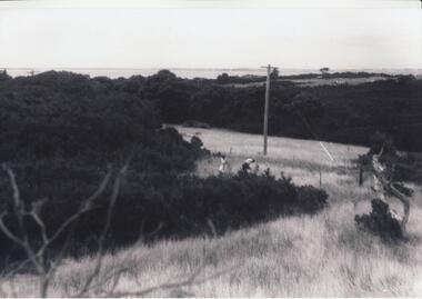 Phillip Island and District Historical Society Inc.
Photographs, Gary Field, 1963
Photographs taken by Gary Field. Lady in photos is Gary's mother. She planted Angophora trees near corner of Daffyd Street and Appley Avenue. (Information supplies by John Eddy).Four black & white photographs of panoramic views from and of Daffyd Street, Red Rocks in 1963, looking north with French Island and the Peninsula on the horizon, view of houses and caravans in Daffyd Street and showing local scrub and housing.daffyd street red rocks, red rocks phillip island, houses 1960's, gary field -
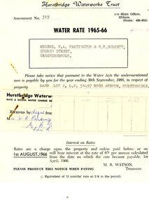 Greensborough Historical Society
Financial record - Account, Hurstbridge Waterworks Trust, Hurstbridge Waterworks Trust water rate assessment 1965-66, 13/05/1965
Hurstbridge Waterworks Trust water rates accounts for land jointly owned by W.A. (Alan) Partington and H.V. (Horrie) Burkett for 2 properties in Hurstbridge (Rose Avenue and Daphne Crescent.Alan Partington and Horrie Burkett had a history of joint property ownership from their early days in Warragul.2 Water rates accounts, black text on white paperHandwritten receipt.alan partington, william alan partington, partington family, horrie burkett, hurstbridge, hurstbridge waterworks trust -
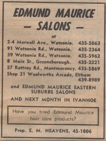 Greensborough Historical Society
Advertisement - Digital image, Diamond Valley News, Edmund Maurice Salons, Watsonia, 1973, 21/08/1973
Advertisement for Edmund Maurice Salons (prop. E. M. Heavens), with salons in Morwell Avenue and Watsonia Road Watsonia, Main Street Greensborough, Rattray Road Montmorency, and Eltham, 1973.Digital copy of newspaper advertisement.watsonia road watsonia, morwell avenue watsonia, main street greensborough, rattray road montmorency, edmund maurice salons -
 Uniting Church Archives - Synod of Victoria
Photographic print block
Glen Iris Presbyterian Church on the corner of High Street and Allison Avenue. The foundation stone was laid by Prime Minister Mr R. G. Menzies and was opened on 21 November 1953. Head and shoulders image of Rev Marsh, Presbyterian minister.On back: "Rev [?] Marsh" "27"glen iris presbyterian church, marsh, rev -
 Friends of Ballarat Botanical Gardens History Group
Work on paper - Scarlet Oak, Ballarat Botanical Gardens 1863 and Ballarat Avenue of Honour (World War1), 5/6/1997 and 2015
By 1863, the Scarlet Oak (Quercus coccinea) was part of the primary exotic tree collection in the Ballarat Botanical Gardens. The Scarlet oak was also found amongst the varieties of trees in the Avenue of Honour.The Scarlet Oak is part of the early planting of exotic trees in the development of the Ballarat Botanical Gardens. A new scarlet oak sapling was planted in 2015 at the northern end of the Gardens.1 page printed on both sides with headings and pictures in colour.Nonescarlet oak, quercus coccinea, john garner, doctor, john garner collection, ballarat botanical gardens, avenue of honour, friends of ballarat botanical gardens, donna thomas, gardens, ballarat -
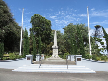
 Eltham District Historical Society Inc
Document - Folder, Avenue of Honour, Eltham, 2007
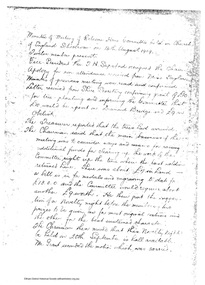
The idea, development and maintenance of an Avenue of Honour followed the suggestion in 1918 to "memoralise the brave deeds of our soldiers" in World War One. It was planted in Main Road, formerly Maria Street, Eltham. Folder contains photocopies of transcribed newspaper articles 1918-1925, photocopy from Eltham Shire Council correspondence, 1921, copy of list of residents from the Shire of Eltham who enlisted in World War One, minutes of "Welcome Home Committee", 1919. Photocopies of photos of Avenue over time. Photocopy: Welcome Home Committee minutes of 14 August, 1919. Fund raising, including a novelty night for medals and engraving to be given to volunteers. From Book 6 - Item 610. The Eltham Council on August 3 1921 to take over the care and maintenance of the Avenue of Honour at Eltham Harry Gilham Collection booklets HG 79, 101 and 10224 pages A4harry gilham collection, avenue of honour, eltham, 1914-1919, homefront, world war 1, ww1, world war 1914-1918, fundraising, welcome home committee -
Whitehorse Historical Society Inc.
Newspaper - Article, Old spacious home key to past Mitcham, 24/01/1968
Article in Nunawading Gazette about 'Windouran', a spacious home unchanged since its picture was used to boost Mitcham's first subdivision sale. It has been divided into 2 flats but still looks stately. In 1915 70 big home sites were sold in an area bounded by Mitcham Road, Halls Parade, Orient Avenue and Vernal Avenue. The estate was known locally as 'Mother Foster's Estate'. Mr James Thatcher brought the brochure to the Gazette - his grandfather, Joseph Lloyd bought land at that sale. David Lloyd (Thatcher's uncle) lived there. James Thatcher had an orchard at that time on a hill above Centre Road, Vermont.houses, windouran, windouran drive, mitcham, mitcham, thatcher, james, mitcham road, mitcham, halls parade, mitcham, orient avenue, mitcham, vernal avenue, mitcham, mother foster's estate, lloyd, joseph, lloyd, david, simon, kingsley -
 Kew Historical Society Inc
Plan - Subdivision Plan, 10 Fine Villa Sites: Ermington Estate, Kew Heights, ca. 1917
Pru Sanderson, in her groundbreaking ‘City of Kew Urban Conservation Study : Volume 2 - Development History’ (1988), summarised the periods of urban development and subdivisions of land in Kew. The periods that she identified included 1845-1880, 1880-1893, 1893-1921, 1921-1933, 1933-1943, and Post-War Development. These periods were selected as they represented periods of rapid growth or decline in urban development. An obvious starting point for Sanderson’s groupings involved population growth and the associated economic cycles. These cycles also highlighted urban expansion onto land that was predominantly rural, although in other cases it represented the decline and breakup of large estates. A number of the plans in the Kew Historical Society’s collection can also be found in other collections, such as those of the State Library of Victoria and the Boroondara Library Service. A number are however unique to the collection.The Kew Historical Society collection includes almost 100 subdivision plans pertaining to suburbs of the City of Melbourne. Most of these are of Kew, Kew East or Studley Park, although a smaller number are plans of Camberwell, Deepdene, Balwyn and Hawthorn. It is believed that the majority of the plans were gifted to the Society by persons connected with the real estate firm - J. R. Mathers and McMillan, 136 Cotham Road, Kew. The Plans in the collection are rarely in pristine form, being working plans on which the agent would write notes and record lots sold and the prices of these. The subdivision plans are historically significant examples of the growth of urban Melbourne from the beginning of the 20th Century up until the 1980s. A number of the plans are double-sided and often include a photograph on the reverse. A number of the latter are by noted photographers such as J.E. Barnes.In November 1917, the Ermington Estate was advertised as an ‘Executor’s Sale’. It included the 10-roomed villa residence, ‘Ermington’, home of the late Mrs. Lorimer, and 10 ‘magnificent allotments’. The plan in the Kew Historical Society Collection is a little more specific. Ermington is described as having 9 Rooms &c. and there are 11 lots shown on the west side of Hillcrest Avenue. In the plan, the latter is named as ‘Hill Crest Avenue’. The plan indicates that the subdivision was based on the surveying work of Johnson & Tait. Opposite Ermington, the existing house ‘Parkhill’ is identified. A faded stamp on two parts of the plan indicates that it was in the possession of Jas. [R.] Mathers, Financial Agent, [136] Cotham Road, Kew.subdivision plans - kew, ermington heights estate - kew heights -
 Kew Historical Society Inc
Plan - Subdivision Plan, Jas R Mathers Son & McMillan, East Kew Tramway Estate, 1915
Pru Sanderson, in her groundbreaking ‘City of Kew Urban Conservation Study : Volume 2 - Development History’ (1988), summarised the periods of urban development and subdivisions of land in Kew. The periods that she identified included 1845-1880, 1880-1893, 1893-1921, 1921-1933, 1933-1943, and Post-War Development. These periods were selected as they represented periods of rapid growth or decline in urban development. An obvious starting point for Sanderson’s groupings involved population growth and the associated economic cycles. These cycles also highlighted urban expansion onto land that was predominantly rural, although in other cases it represented the decline and breakup of large estates. A number of the plans in the Kew Historical Society’s collection can also be found in other collections, such as those of the State Library of Victoria and the Boroondara Library Service. A number are however unique to the collection.The Kew Historical Society collection includes almost 100 subdivision plans pertaining to suburbs of the City of Melbourne. Most of these are of Kew, Kew East or Studley Park, although a smaller number are plans of Camberwell, Deepdene, Balwyn and Hawthorn. It is believed that the majority of the plans were gifted to the Society by persons connected with the real estate firm - J. R. Mathers and McMillan, 136 Cotham Road, Kew. The Plans in the collection are rarely in pristine form, being working plans on which the agent would write notes and record lots sold and the prices of these. The subdivision plans are historically significant examples of the growth of urban Melbourne from the beginning of the 20th Century up until the 1980s. A number of the plans are double-sided and often include a photograph on the reverse. A number of the latter are by noted photographers such as J.E. Barnes.The East Kew Tramway Estate was a subdivision of two separate parcels of land between Adeney Avenue and Normanby Road. The larger section included 54 lots facing Adeney Avenue, Argyle Road, and Campbell, Hunter and Wishart Streets. [Hunter and Wishart Streets were created as part of the subdivision.] A further 17 allotments faced Normanby Road, Hubert and Campbell Streets. [The name of Hubert Street was later to be changed to Cecil Street.] The promotion of the sale referred to the advantages of living between two tram routes, in High Street and Cotham Road. On the plan, quaintly drawn trams mark these routes. Also on the plan is the route of part of the Outer Circle [Railway] Line.east kew tramway estate, subdivision plans - east kew -
Glen Eira Historical Society
Article - Dorothy Avenue, 20, Glen Huntly
This file contains four items about this property: 1/6 pages on history of 20 Dorothy Avenue, 4 pages are photocopied photographs of home exterior and interior. 2/Printout from Museum Victoria website showing model of D C Gallager House Glenhuntly, designed by A V Jennings’ first architect Edgar Gurney. 3/Photocopied article from unknown source about proposals to add another story to their house in 1977/1978. 4/Photocopy of Certificate of Title for 20 Dorothy Avenue, Glenhuntly.d. c. gallager house, glenhuntly, a v jennings, gurney edgar, architects, barnard e. f., dorothy avenue, macgowan avenue, house styles, brick, gallagher dudley chas, glenhuntly road, newsagents, dargie william alexander, artists, martin ernest james, mechanics, marek christine, marek joseph, dargie kathleen, dargie roger, dargie faye, charlestworth ted, quin damien, rooms, architectural features, architectural styles -
 Melbourne Tram Museum
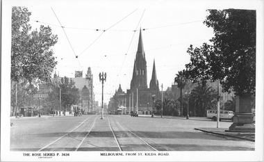
Postcard, Rose Stereograph Co, "Melbourne from St Kilda Road", late 1930s
Rose Series postcard No. P 3636, titled "Melbourne from St Kilda Road", looking north from just south of Alexandra Avenue. Note how the tram tracks are widened to pass around the center of the road light standard which appears to be marked as a tram stop. In front of the photo, a tram crossover can be seen. There is a tour bus parked at the start of Alexandra Avenue. See item 8044 for a similar view. The Edmund Fitz Gibbon Memorial is on the right in its original position in St. Kilda Road.Yields information Swanston Street and St Kilda Road in the late 1930s.Postcard - printed real photograph with Rose Stereograph Co. name on the rear.tramways, trams, st kilda road, alexandra ave -
 Ringwood and District Historical Society
Document - Folder, Byways Estate Residential Subdivision, Ringwood East, Victoria 1965-1970
Collection of Subdivision brochures, plans, maps and sales information for sectional releases of Byways Estate.Subdivision plans include: First and second release (1965-66) - Alexandra Road, Isabel Avenue, Byways Drive and Buronga Avenue. Third release (1967) - Byways Drive, Buronga Avenue, Hender Street, Lester Avenue and Jess Court. Fourth and final release (1970) - Hume Street, Walhalla Drive and Hender Street. (Agent) C.E. Carter & Son R.E.S.I. 126 Whitehorse Road, Ringwood, 3134 (Telephone) 870 2519, 870 6830, 870 6024, A.H. 723 3298, 870 4604, 870 6454. Accompanying handwritten sales notes researched in 2024 by Richard Carter - Carter Real Estate - "Vendors - Jessie May Cleland & Alan Cleland of (what became) 4 Bywats Drive. Vendors retired to Buronga near Mildura. Rex was (I think) their son. Jess Court reflects vendor's name. See also History of Byways & Coolooli by Richard Carter in RDHS archives." (Vic Collections RDHS 18023 refers.) -
 Ringwood and District Historical Society
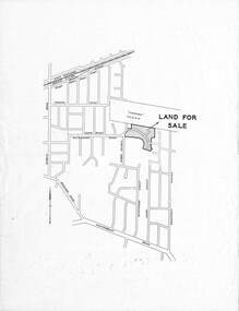
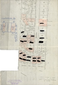
Document, Map showing numbered subdivision allotments with hand-written notations and redactions - 1924
Foolscap size page Map by Arnold Wilson & Associates, Engineers & Surveyors, 399 St.Kilda Road, Melbourne, Tel 26-1840 - 1924/4. Subdivision includes Ilford Road, Karen Court, Washusen Road and Dirkala Avenue, Heathmont. Also includes hand-drawn allotments on Canterbury Road and Balfour Avenue. Page rubber-stamped by building company A & C Jaworski, Office 2, 23 Ringwood Street, Ringwood 3134, Tel 870-0820, A.H. 870-2062. -
 Ringwood and District Historical Society
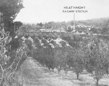
Photograph, View of what was Heathmont township taken from about Royal Avenue looking at Mr. Herman Pump's orchard. Old bridge over Canterbury Road can be seen on left
Typed below photograph, "View of what was Heathmont township taken from about Royal Avenue looking at Mr. Herman Pump's orchard. Old bridge over Canterbury Road can be seen on left." -
 Ringwood and District Historical Society
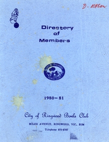
Booklet, Ringwood Bowls Club- Directory of Members, 1980-81
Blue coloured bookletOn front cover Directory of Members, 1980-1981 City of Ringwood Bowls Club Miles Avenue, Ringwood, Vic, 3134. Inside booklet is typed list of Members in alphabetical order with address and phone number. -
 Phillip Island and District Historical Society Inc.
Photograph Folder, approx 1940's - 1950's
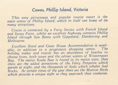
Coloured Souvenir folder of 12 postcards donated by M Arnell.Souvenir Colour Folder of 12 colour postcards of Cowes and Phillip Island. Photographs Include: Cowes Beach, Cowes Pier, Koalas, Cowes Township, The Nobbies, Summerland Surf Beach, Suspension Bridge, Thompson Avenue, Cowes, Penguin Parade, Seal Rocks, The Isle of Wight Hotel and The Blowhole.Front cover: A Souvenir of Picturesque Cowes. A Special selection of Scene in Full Colour.phillip island, cowes phillip isand, the isle of wight hotel cowes phillip island, the blowhole phillip island, penguins, koalas, seals, m arnell -
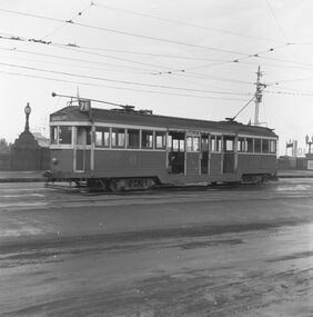 Ballarat Tramway Museum
Negative, Geoff Grant, 7/05/1955 12:00:00 AM
Negative No. 291 and colour print made by colour laser printer (stored in folder ) of W2 440 leaving Batman Avenue terminus on route 76 Camberwell Depot? on 7/5/1955. Photo by Geoff Grant. Hi res scan of negative and image updated 19/5/2020.trams, tramways, melbourne, batman ave, tram w2 440 -
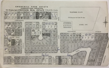 Kew Historical Society Inc
Plan - Subdivision Plan, Churchill Park Estate, Templestowe
Historic subdivision plan of the Churchill Park Estate in Templestowe.Undated subdivision plan advertising the Churchill Park Estate inTemplestowe. Streets identified in the plan include: Corroboree Place, Astley Street, Jeffrey Street, Airds Road, Dove Court, Potter Court, Thompsons Road, Richards Street, and Birchwood Avenue. This record includes a copy of the price list.Annotations in ink on the plan by agentsubdivision plans - templestowe (vic), churchill park estate - templestowe (vic) -
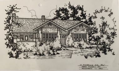 Kew Historical Society Inc
Drawing - Property Illustration, Margaret Picken, 10 Florence Avenue, Kew, 1989
This architectural drawing is one of a series created by Margaret Picken for a number of real estate agents in Melbourne between 1983 and 2005. Each work is signed and dated by the artist.Gift of Margaret Picken, 2020Extant (as of 2020) red brick house in the Federation Bungalow style. Built in 1920, with additions and alterations to the interiors and rear of the property in 1970 and 1989. In 2003 a gazebo was added at the rear. This pen and ink architectural drawing on drafting film of 10 Florence Avenue, Kew was made by Margaret Picken in 1987.10 FLORENCE AVE., KEW / MARG. PICKEN '87 / WOODARDS ~ KEWartist -- margaret picken 1950-, architectural drawings -- houses -- kew (vic.), 10 florence avenue - kew (vic). -
 Melbourne Tram Museum
Photograph - Black & White Photograph/s, Tom Murray?, 1970's?
Black and white photograph of W5 727 in the reserved track section at Mathews Avenue, Niddrie, Essendon Airport line, possibly for an Australian Railway Exploration Association Tour to Tasmania. Possibly during the 1970's. Has the destination of "Tasmania via Essendon Airport" with the crew standing along side.trams, tramways, charters, special trams, tours, essendon airport, tram 727 -
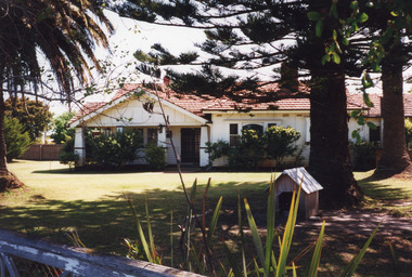 Lakes Entrance Historical Society
Photograph - Historic House, 1999
Originally had corrugated iron roof, additions to house in 1950's, internal alterations, roof tiled.Colour photograph of a Californian Bungalow style dwelling at 15 Barkes Avenue. Outer walls of timber and cement render. Tiled roof has hips and valleys, gables above the veranda. Brick and concrete solid square veranda columns. Upper windows with leaded quarries. Lakes Entrance Victoriahouses, heritage study -
 Phillip Island and District Historical Society Inc.
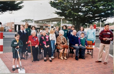
Photograph, Centennial planting of trees in Cowes 1994
Centennial planting of golden cyprus trees in Thompson Avenue, Cowes. 2/9/1994. Megan Fuller was grand daughter of Min Lawrence, Matthew Wright was great grandson of Peter ForrestHistorical Coloured photo of people sitting and standing on path in Cowes. 4 guests seated and 1 official standing. Group of schoolchildren behind them. One girl with spade at front left. Also 4 strips of negatives [ 13 photos] taken at the same function.Centennial planting of trees at Cowes. Seniors - Edna Thompson, Min Lawrence, Isa Niven, Peter Forrest & grandchildrengolden cyprus trees, centennial, edna thompson, min lawrence, isa niven, megan fuller, peter fuller, matthew wright -
 Eltham District Historical Society Inc
Photograph, Barry Philp, Looking north from Main Road to Storey Avenue, Research, c.1969
Taken from Main Road looking north to the houses in Storey Avenue and the Maroondah Aqueduct. From the appearance of the pine trees along the aqueduct it was taken just after the 1968-1969 fire.research (vic.), bushfires, main road, maroondah aqueduct, pine trees, storey avenue, victorian bushfires - 1969 -
Glen Eira Historical Society
Letter - Tucker Road, 197, Bentleigh
Copy of letter dated 03/02/1977 by sworn valuator to Charles Latham regarding land purchase at rear of 197 St. James Avenue. Also includes hand drawn plan.latham charles, st. james avenue, scott w.v., land values, local government, houses, home units, tucker road, bentleigh