Showing 2278 items
matching parish.
-
 Greensborough Historical Society
Map, Melbourne and Metropolitan Board of Works. Survey Division, MMBW, Yarra 2500 / 11.22. Bundoora, 1979_01
Melbourne and Metropolitan Board of Works. Yarra 2500 [base map] 11-22. Bundoora. Parish of Keelbundoora 2856, Municipalities of Diamond Valley 257 and Whittlesea 239. Prominent streets include: Greenhills Road, Cabernet Crescent and Plenty Road. Includes Parade College (Christian Brothers) and "proposed future freeway" (now Metropolitan Ring Road)MMBW Map in 1:2500 [scale] series. Cream parchment with green tape reinforcing on edges and punched holes on left edge.mmbw, melbourne and metropolitan board of works, shire of diamond valley, bundoora - maps -
 Greensborough Historical Society
Map, Melbourne and Metropolitan Board of Works. Survey Division, MMBW, Yarra 2500 / 15.21. Eltham North, 1979_08
Melbourne and Metropolitan Board of Works. Yarra 2500 [base map] 15.21. Eltham North. Parish of Nillumbik 3310. Municipalities of Diamond Valley 257 and Eltham 238. Prominent streets include: Progress Road, Glen Park Road and Zig Zag Road. Features include the Diamond Creek, Eltham Council Pound and Eltham North Reserve.MMBW Map in 1:2500 [scale] series. Cream parchment with green tape reinforcing on edges and punched holes on left edge.mmbw, melbourne and metropolitan board of works, shire of diamond valley, nillumbik, eltham - maps -
 Greensborough Historical Society
Map, Melbourne and Metropolitan Board of Works. Survey Division, MMBW, Yarra 2500 / 14.23. Diamond Creek, Sutherland Homes, 1979_05
Melbourne and Metropolitan Board of Works. Yarra 2500 [base map] 14.23. Diamond Creek, Sutherland Homes. Parish of Morang 3183 and Nillumbik 3310. Municipality of Diamond Valley 257. Prominent streets Aqueduct Road, Diamond Creek Road, Yan Yean Road and McLaughlans Lane. Features include the abandoned Maroondah aqueduct and Sutherland Cottages.MMBW Map in 1:2500 [scale] series. Cream parchment with green tape reinforcing on edges and punched holes on left edge.mmbw, melbourne and metropolitan board of works, shire of diamond valley, plenty - maps, sutherland homes, maroondah aqueduct -
 Greensborough Historical Society
Map, Melbourne and Metropolitan Board of Works. Survey Division, MMBW, Yarra 2500 / 15.24. Diamond Creek, Grassy Flat Road, 1978_02
Melbourne and Metropolitan Board of Works. Yarra 2500 [base map] 15.24. Diamond Creek, Grassy Flat Road. Parish of Nillumbik 3310. Municipality of Diamond Valley 257. Prominent streets include: Everleigh Drive, Broad Gully Road and Clyde Street. Features include the Diamond Creek, Nillumbik Park and Diamond Creek Reservoir.MMBW Map in 1:2500 [scale] series. Cream parchment with green tape reinforcing on edges and punched holes on left edge.mmbw, melbourne and metropolitan board of works, diamond creek - maps, shire of diamond valley -
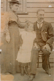 City of Moorabbin Historical Society (Operating the Box Cottage Museum)
Photograph, Black & White, Adelaide Bleazby, Frank Box, Daisy c1900, c1900
Frank Box was descendant of the Box family who migrated from Sussex England c 1850 and established market gardens in the area of Henry Dendy's Special Survey 1841 Brighton', Parish of Moorabbin, County of Bourke. Frank married Adelaide Bleazby in 1873 and they are shown here with their daughter, Daisy , at Kilgour Street Geelong Victoria c1900The Box family were pioneer settlers in the Parish of Moorabbin, County of Bourke c 1850 in the area of Henry Dendy's 'Special Survey Brighton 1841'. They established market gardens and raised their children.Faded Black & White photograph of Adelaide Bleazby, Frank Box and daughter Daisy at Geelong c1900Back handwritten information unsignedbox george, box william, box elizabeth, box francis, box cottage museum ormond, city of moorabbin historical society, bleazby adelaide 1873, box frank smith j l; smith mary ann, stanley helen, smith vic, chaff cutter, horse drawn carts, toll gates brighton, motor cars 1900, steam engines, early settlers, bentleigh, mckinnon, parish of moorabbin, city of moorabbin, county of bourke, moorabbin roads board, shire of moorabbin, henry dendy's special survey 1841, were j.b.; bent thomas, o'shannassy john, king richard, charman stephen, highett william, ormond francis, maynard dennis, market gardeners, vineyards, orchards -
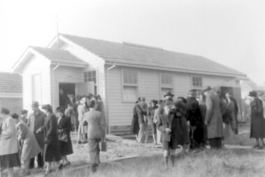 Surrey Hills Historical Society Collection
Photograph, Opening of St Theodore's Church, Wattle Park, 1953
The church was opened in 1947. Andrew Ward wrote a history of it in 1987. Title: " St Theodore's Anglican Church Wattle Park - A History of a Small Parish: 1947-1987." (Not in our collection) Norman Carter took many photos of Surrey Hills and Mont Albert from the 1920s; many were associated with events and activities of the Church of England.Black and white photo of a large group of people gathered around the exterior of a simple, light coloured timber building with a porch with a side door and 3 sash hung windows. The surrounding ground is crudely landscaped.On back in ink: "Opening / St Theodores Wattle Park / prob. 1953"st theodore's church, churches, anglican churches, wattle park, norman carter -
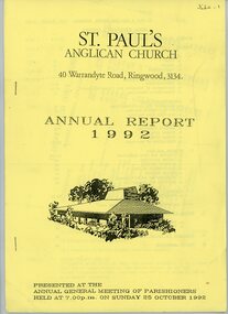 Ringwood and District Historical Society
Annual Reports, St Paul's Anglican Church Ringwood: Annual Reports 1992 and 1995, 1992-1995
St Paul's Anglican Church, 40 Warrandyte Road, Ringwood, 3134. Annual Report 1992 - pale yellow cover, 40 pages - presented at the annual general meeting 25 October 1992 (Budget proposal 1992-93 insert), and Annual Report 1995 - yellow cover, 40 pages, - presented at the annual parish meeting 5 November 1995. -
 Ringwood and District Historical Society
Badges, Collection of badges from different Ringwood organisations and events, 1960 - 1970s
A collection of seven badges from different Ringwood organisations and events.; 1. Iceland Ringwood Dance Club; 2. City of Ringwood 1960; 3. Ringwood Rifle Club; 4. Ringwood H&A Society; 5. 90 Ringwood Lanes; 6. Maroondah Hospital Appeal; 7. Holy Trinity Parish Fair - 18-19 Oct 1974 No. 423 -
 Kiewa Valley Historical Society
Book - Kiewa Voters' Roll, Shire of Bright - Voters' Roll 1979 - Kiewa Riding, 1979
Electoral rolls list people who are registered and eligible to vote at federal, state, territory & local government elections and referenda. Prior to 1990 the rolls list voters in alphabetical order by surnames & first names within each Sub division of an electoral division of each State or Territory. The roll is useful & interesting for family historians and the study of demographics. Alex McCullough lived in the Shire of Bright and was on its Council. Electoral roles help to locate the residential address of a person in a particular year or over a period of years. They can be used as a substitute for census records for family historians and the history of a particular place in this case the Kiewa Valley - Tawonga and Tawonga South.Approx. 60 pages of firm yellow paper with black typed print on one side only in 'landscape' format. Held by three staples. Each page has column - numbered 1 to 943; Surnames in alphabetical order; Given names; Occupation; includes L (=land). Address followed by Lot number and parish. Includes Tawonga and Tawonga SouthOn the cover on the right hand side handwritten and difficult to read - "Jack? / Indi / Benambra / Nth Eastern / Division? of Dawson / 123 Victoria Rd. / Melbourne 3000"shire of bright; kiewa riding; voters roll; alex mccullough; tawonga; tawonga south -
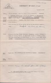
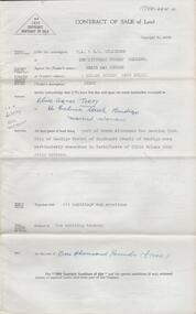
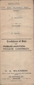 Bendigo Historical Society Inc.
Document - H.A. & S.R. WILKINSON COLLECTION: CONTRACT OF SALE
Conditions of sale by private contract dated 11th September, 1930 between J. Beercroft (seller) and J. Smith (buyer) for pieces of land outlined in red on the plan hereon and owned and or occupied by the vendor at Epsom, being part of allotments 2, 3 and 4 section 8 in the Parish of Huntly. Price 200 pounds. Attached plan of the land sold.organization, business, h.a. & s.r wilkinson real estate -
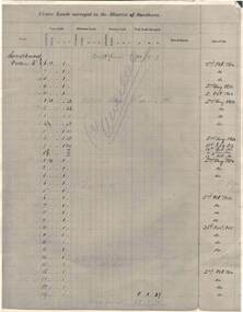 Bendigo Historical Society Inc.
Document - RAILWAYS COLLECTION: CROWN LANDS SURVEYED IN DISTRICT OF SANDHURST
RAILWAYS COLLECTION -large cream -coloured paper photocopy of 'Crown Lands Surveyed in District of Sandhurst' x 2 Information has been entered into columns showing Parish, Town Lands, Suburban Lands, Country Lands, Total Lands Surveyed, Date of Survey, Date of Sale, most Dates of Sale are 1854 The documents have been cancelled.document -
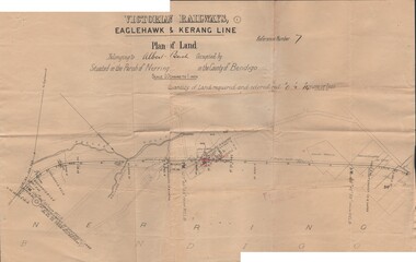 Bendigo Historical Society Inc.
Document - BUSH COLLECTION: PLANS PERTAINING TO LAND OF S. A. BUSH
A: Plan of subdivision of Allots 6, 7, 8, 15 & 16, Sec. 62C, City of Bendigo (The Property of Albert Bush, Esq.) - Plan is torn in half forming two pieces (see 'Condition'. Pinned note attached to one piece. B: Victoria Railways, Eaglehawk & Kerang Line (Albert Bush land, Parish of Nerring, County of Bendigo.person, individual, bush collection - personal -
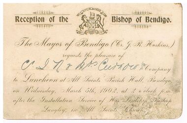 Bendigo Historical Society Inc.
Document - CURNOW COLLECTION: INVITATION TO MAYOR CURNOW, 05/03/1902
White card with rounded corners. The Mayor of Bendigo (Cr. J. R. Hoskins,) inviting Cr. J. H. Curnow & Mrs Curnow to a luncheon at All Saints Parish Hall, Bendigo, on Wednesday, March 5th, 1902, after the Installation Service of His Lordship, Bishop Langley, in All Saints Church. City of Bendigo emblem at the top of card.document, invitations, luncheon, document, invitation to reception of the bishop of bendigo, cr j r hoskins, cr j h curnow & mrs curnow, bishop langley -
 Bendigo Historical Society Inc.
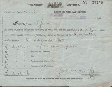
Document - L. PROUT COLLECTION: TREASURY VICTORIA RECEIPT
Treasury Victoria receipt No. 37759. Licence or Lease no. 12. Revenue and pay office, Bendigo 22 June, 1923. Received from mr. Jones the sum specified below in payment of rent for the occupation of 35 acres of land in the parish of Kimbolton under section 8 of the land act 1911. The sum paid is 2 pounds, 12 shillings and 6 pence.document -
 Bendigo Historical Society Inc.
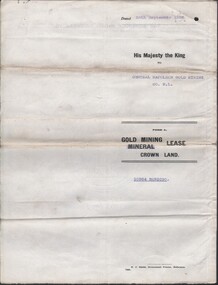
Document - MCCOLL, RANKIN AND STANISTREET COLLECTION COLLECTION: CENTRAL NAPOLEON GOLD MINING CO. N.L, 26th September 1938
Document: Gold Mining Lease Crown Land No. 10964 Bendigo, Entered in the register books, Vol. 322 Fol. 33571, Embossed seals of Central Napoleon and King George VI, Map: Mining District of Bendigo, County of Bendigo, Parish of Sandhurst, located at Harvey and Inglis Streets, During the reign of King George VI (Originally marked Edward VIII).organization, business, industry - mining, mccoll rankin & stanistreet, mining, gold mining, central napoleoon -
 Whitehorse Historical Society Inc.
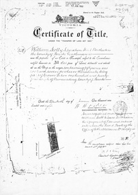
Document, Certificate of Title, 1/06/1908
Photocopy of Certificate of Title Vol 3271 Fol 654003, 50 acres fronting on Canterbury Road, including Scott Street being part of Crown Portion 124, Parish of Nunawading, County of Bourke, in the name of William Scott, 20 June 1908; transfers to 8 October 1936 with notes of previous owners of parts of lot 124 from November 1858.scott street, mitcham, scott, william, polak, nelson, land subdivision, canterbury road, vermont, mitcham road, isaak, johnson, miller frederick, james, becker, lydia malvina, huffey, harry, graham, annie bella, langford, william allan, emily mary, caplin, ethel grace, armstrong, mary, cook, joseph allan, isabella, isaac william, mettzke, frederick oscar, whitmore, doris margaret, elizabeth, thomas, stephen, beach, william griffin, brown, hosking, bonnel, alphonse, saul, martin, richards, twose, richard frederick, charles, george, ham, cornelius job, sprigg, shaw, gavin, william barker, jane, mcclelland, david goodwin, thomas robert -
Whitehorse Historical Society Inc.
Letter - Correspondence, Office of Lands and Survey, 1861
Copy of letter written by W. Fletcher, Office of Lands and Survey, Melbourne, 2 Nov 1861.Copy of letter written by W. Fletcher, Office of Lands and Survey, Melbourne, 2 Nov 1861. Reporting that charcoal burners in the Parish of Nunawading are using wood for that purpose without a license and suggesting the policeman at Whitehorse by informed. Attached note suggests author is possibly Walter Thomas Fletcher, early owner of land that included what is now Matheson's orchard (1988).Copy of letter written by W. Fletcher, Office of Lands and Survey, Melbourne, 2 Nov 1861.charcoal burning, fletcher, w, forest hill, parish of nunawading -
 Bendigo Historical Society Inc.
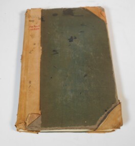
Administrative record - Land sales applications
Green cover book with brown leather spine. The book lists the applications for allotments of land for sale. The headings in the book are: number of application, date of registry, date of application, surname, Christian name and address, parish, allotment, section, area, local land board, Licence dated, licence issued, references and remarks. The book covers the years 1908-1960.On the cover in black ink "Castlemaine" and in red ink "138 front, 130 Rear" On the first page in pen: 138-129 front 130-121 back.land sales, castlemaine -
 Bendigo Historical Society Inc.
Document - LANDS OFFICE: CROWN LAND SALES 1855 - 1857, 1855 - 1857
Document: LANDS OFFICE: CROWN LAND SALES 1855 - 1857 brown hard covered journal with buff corners and spine. Contains 200 pages with details of crown land sales. LH page: lot, sec., allotment, county, parish, area, upset price, deposit, amount RH page: val. name of purchaser, name of owner of improvement, remarks.Lands Officeland sales 1855 - 57, lands office, sandhurst, bendigo, land sales, crown land -
 Warrnambool and District Historical Society Inc.
Audio - Audio tapes, Shire Centenary meeting 1963, Circa 1963
The Warrnambool Shire commenced in 1863 and was 613 square miles in area and had a population of about 8000. It was divided into three ridings each with three councillors. Its industries were dairying, general farming, cheese and butter making, wool growing, sheep and cattle raising. There are more than 20 parishes and more than 29 small townships in the area The industries, agriculture, and people of the Warrnambool Shire provided substantial support to the city of Warrnambool over a long period of time. Three audio reel to reel tapes two in green and white boxesShire Centenary meeting 1963 tape1, 2, 3. depth. Two tapes stored in grey and white cardboard box, Irish recording tape, a product of AMPEXwarrnambool, warrnambool shire council, warrnambool shire centenary -
 Greensborough Historical Society
Map, Melbourne and Metropolitan Board of Works. Survey Division, MMBW, Yarra 2500 / 13.19. Lower Plenty, Montmorency, Yallambie, 1979_02
Melbourne and Metropolitan Board of Works. Yarra 2500 [base map] 13-19. Lower Plenty, Montmorency, Yallambie. Parishes of Keelbundora 2856 and Nillumbik 3310. Municipalities of Heidelberg 228, Diamond Valley 257 and Eltham 238. Prominent streets include: Elder Street, Para Road, and Main Road Lower Plenty. Includes Watsonia Army Barracks.MMBW Map in 1:2500 [scale] series. Cream parchment with green tape reinforcing on edges and punched holes on left edge.mmbw, melbourne and metropolitan board of works, shire of diamond valley, montmorency - maps, yallambie - maps, lower plenty - maps -
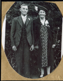 City of Moorabbin Historical Society (Operating the Box Cottage Museum)
Photograph, Alfred Amos , Gertrude Emma Box 1941, c1941
William and Elizabeth Box migrated from Sussex England c1850 and established a market garden in the area of Henry Dendy's 'Special Survey Brighton 1841' in the Parish of Moorabbin, County of Bourke. William's parents, George & Mary Box followed in 1856 bringing 6 of their 10 children and joined William in East Brighton ( Bentleigh) Gertrude Emma Box is a descendant of this family.The Box family were pioneer settlers in the area of 'Henry Dendy's Special Survey 1841' Brighton and established market gardens .Black & White photograph of Alfred Amos and Emma Gertrude Box c1941box william, box mary nee cripps, box elizabeth avis, box george b 1808, box gertrude emma, amos alfred, smith j l; smith mary ann, stanley helen, smith vic, s horse drawn carts,, early settlers, bentleigh, mckinnon, parish of moorabbin, city of moorabbin, county of bourke, moorabbin roads board, shire of moorabbin, henry dendy's special survey 1841, were j.b.; bent thomas, o'shannassy john, king richard, charman stephen, highett william, ormond francis, maynard dennis, market gardeners, vineyards, orchards -
 Uniting Church Archives - Synod of Victoria
Photograph, Reverend Peter Davis, 1980
Reverend Peter K. Davis was ordained in 1954. He served at Nimbin, Milton and in Fiji. He was President of Conference between 1969 and 1971, served at Gladesville, Newtown, Overseas Mission (CFWM), Wesley Central Mission and Leichhardt-Petersham Parish Mission. He retired in 1992. The photograph accompanied the anouncement of Reverend Davis' appointment as incoming NSW Moderator.B&W head and shoulders photograph of Rev Peter Davis."Davis September 26 p.16"davis, peter k., moderator -
 Ballarat Heritage Services
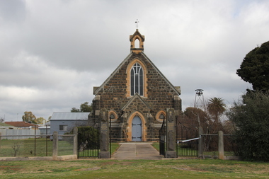
Photograph - Photograph - Colour, L.J. Gervasoni, St Paul's Anglican Church, Carisbrook, 2011, 06/08/2011
Anglican services were first held in Carisbrook in 1851. In 1854 church services and a school were conducted in the Parish Hall. In 1864 - 1866 the blue stone church was erected. The interior was renovated in 1966 and the vestry was added in 1972. St Paul's Carisbrook was decommissioned in 2015, with the last service being held on 31 October 2015 after 149 years of worship.Colour photograph of a Church at Carisbrook, Victoria.carisbrook, church, st paul's anglican church carisbrook, carisbrook church of england -
 Federation University Historical Collection
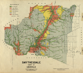
Map, Smythesdale, County of Grenville, 1888, 1889
The map maker, Ferdinand M. Krause, was a professor at the Ballarat School of Mines. This land was printed form the Crown Lands Department, Melbourne. Coloured map of the County of Grenville. The edge has been taped. The scale is 40 chains to 1 inch. The map is accompanied with a foolscap sheet printed by the Mines Department in 1898. It is a Report on the Parish of Smythesdale by F.M. Krause and includes information on the water reserve, worked quartz veins, Watson's Hill, Surface Hill and Sugarloaf Hill, Haddon, Trunk Lead and the Crucible Shaft. smythesdale, krause, f.m. krause, ferdinand krause, nitingbool, watson's hill, surface hill, sugarloaf hill, haddon -
 Bendigo Historical Society Inc.
Document - H. A. & S. R. WILKINSON COLLECTION: CONTRACT OF SALE
Contract of sale of land dated 10th July, 1952 between Mrs. E. P. M. McDonald (vendor) and Mrs. Threlfell (purchaser). Property: land being Crown allotment 19 section 15B City of Bendigo Parish of Sandhurst, land comprised in certificate of title volume 2567 folio 513352, together with all buildings thereon. Price: 900 poundsorganization, business, h.a. & s.r wilkinson real estate -
 Bendigo Historical Society Inc.
Document - H. A. & S. R. WILKINSON COLLECTION: CONTRACT OF SALE
Contract of sale of land dated 11th October, 1951 between Mrs. G. M. Wicker (vendor) and Mrs. O. A. Torpy (purchaser). Property: land being part of Crown allotment 10 section 100C City of Bendigo Parish of Sandhurst land described in certificate of title volume 6160 folio 1231986, together with all buildings thereon. Price: 1,000 pounds.organization, business, h.a. & s.r wilkinson real estate -
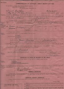 Bendigo Historical Society Inc.
Document - ERROL BOVAIRD COLLECTION: WHEAT BOUNTY CLAIM
The John Bovaird Collection : Commonwealth of Australia Wheat Bounty Act 1934 State of Victoria Claim for Payment. By Errol Balfour Bovaird of May Reef PO via Avonmore. Regarding 150 bushels delivered for sale to John T Stewart of Lockington. Wheat produced on 50 acres : Allotment 25 Parish of Pannoo Bamawm. Dated 13/4/1935. Pink paper.agriculture, farm, wheat crop -
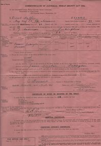
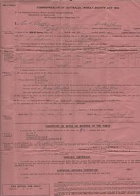 Bendigo Historical Society Inc.
Document - ERROL BOVAIRD COLLECTION: WHEAT BOUNTY CLAIM
The John Bovaird Collection. Commonwealth of Australia Wheat Bounty Act 1934 State of Victoria Claim for Payment. By Errol Balfour Bovaird of May Reef PO via Avonmore. Regarding 96 bushels delivered for sale to R. Anderson of Lockington. Wheat produced on 50 acres : Allotment 25 Parish of Pannoo Bamawm. Dated 13/4/1935. Pink paper.agriculture, farm, wheat crop -
 Bendigo Historical Society Inc.
Document - ERROL BOVAIRD COLLECTION: WHEAT BOUNTY CLAIM
The John Bovaird Collection. Commonwealth of Australia Wheat Bounty Act 1934 State of Victoria Claim for Payment. By Errol Balfour Bovaird of May Reef PO via Avonmore. Regarding 96 bushels delivered for sale to R. G. Anderson of Lockington. Wheat produced on 50 acres : Allotment 25 Parish of Pannoo Bamawm. Dated 13/4/1935. Pink paper.agriculture, farm, wheat crop