Showing 3758 items
matching surveyed
-
 Bendigo Military Museum
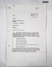
Letter - Army Survey Regiment - Letter of request for additional computer disk space for Automap 2, Army Survey Regiment, 19 Feb 1987
Automap 2 was the Army Survey Regiment's computerized Mapping system. This letter is a request for an additional 700 Mb of computer disk space for the Automap 2 System because of newly developed applications. Those applications were: Analytical Hill shading, Digital Terrain Modelling, Mask and stipple Production, RAAF Chart symbol Placement, ASTIS - Army Survey - Topographic Information System, and, Map Catalog Production.Two page letter, foolscap size, Stapled top left corner"A Spurling, Computer Operations Manager for CO"royal australian survey corps, rasvy, fortuna, army survey regiment, army svy regt, asr -
 Bendigo Military Museum
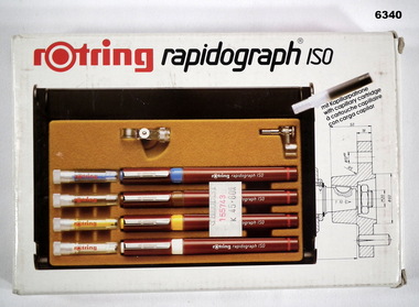
Equipment - Rotring Rapidograph Iso Pen set, Circa 1980
Used extensively within the Royal Australian Survey Corps for the compilation of maps and for map overlay production. These pens produced lines of consistent line widths for cartographic ink work and these replaced the earlier "Crow Quill" ink nib pens. These pens were donated by 310762 WO1 PJ Presser (dec) who served in the Royal Australian Survey Corps from 11 Feb 1970 - 12 Feb 1990.Rotring box Rapidograph Iso pen set with four pens in a plastic case and two compass adaptors. Pen sizes: 0.25mm, 0.35mm, 0.50mm, 0.70mm, with instructionsroyal australian survey corps, rasvy, fortuna, army survey regiment, army svy regt, asr -
 Kew Historical Society Inc
Archive (series) - Subject File, Victoria Park : Concept Management Plan, Research Papers, 2004
Graeme Butler & AssociatesProject FilesProvenance OrderRed cardboard wallet containing historical research by Graeme Butler, heritage architect, into the history of Victoria Park, Kew. The file also includes a draft Victoria Park Concept Master Plan, 2004. The research includes memoranda, maps, photocopies of plans, forms, notes, aerial photos, and sundry references.graeme butler - heritage architect, victoria park - kew (vic), heritage studies - kew (vic.)graeme butler - heritage architect, victoria park - kew (vic), heritage studies - kew (vic.) -
 The Beechworth Burke Museum
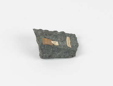
Geological specimen - Greenstone / Gabbro, Unknown
This specimen was recovered from Ceres West of Geelong, Victoria. Greenstone is the name for any metamorphosed basic igneous rock (in the case of this specimen, Gabbro) that gains its greenish colour to the presence of the minerals chlorite, actinolite, or epidote, hence the term 'green' and 'stone'. Greenstone is often formed through metamorphsis along a convergent plate boundary. In the rock cycle (the series of processes that creates the various types of rocks) there are identified three different types of rocks, which are the sedimentary, the igneous and the metamorphic. Metamorphic rocks started out as sedimentary, igneous or earlier metamorphic rocks but changed from their original condition under the effect of high heat, high pressure or hot, mineral-rich fluid. However, if pressure or heat is too high, then the rock will melt, resulting in the formation of an igneous rock. The name used to describe these types of rocks reflects this specific inherent trait of change, since the word “metamorphic” derives from the Greek word “metamorphosis”, meaning “change of form or structure”. Metamorphic rocks form in the Earth`s crust but can be also found on the surface, due to elevation of the Earth`s surface. They are divided into two categories: the foliated metamorphic and the non-foliated metamorphic rocks. Gabbro is a highly useful mineral that is often polished to create cemetery markers and kitchen benches. It is notable for its qualities of durability, being able to withstand extreme elements and wear. Whilst not rare, Gabbro is of great utility and has been highly desirable for its qualities. This specimen is part of a larger collection of geological and mineral specimens collected from around Australia (and some parts of the world) and donated to the Burke Museum between 1868-1880. A large percentage of these specimens were collected in Victoria as part of the Geological Survey of Victoria that begun in 1852 (in response to the Gold Rush) to study and map the geology of Victoria. Collecting geological specimens was an important part of mapping and understanding the scientific makeup of the earth. Many of these specimens were sent to research and collecting organisations across Australia, including the Burke Museum, to educate and encourage further study.Greenstone is a solid hand-sized metamorphic mineral of a green colour. Greenstone is the name for any metamorphosed basic igneous rock (in the case of this specimen, Gabbro) that gains its greenish colour to the presence of the minerals chlorite, actinolite, or epidote, hence the term 'green' and 'stone'. Gabbro is a medium to coarse grained rocks that consist primarily of plagioclase feldspar and pyroxene. Greenstone is often formed through metamorphsis along a convergent plate boundary. Gabbro forms due to cooling and crystallization of magma underneath Earth's surface. Greenstone/Gabbro/from Ceres west/of Geelong. Has old Geological Survey label/and probably collected by/Richard Daintree in 1861/C.Willam 15/4/21/ Other label: 62 /greenstone, metamorphosed, igneous rock, gabbro, chlorite, actinolite, epidote, metamorphsis, rock cycle, various types of rocks, sedimentary, high heat, high pressure, mineral-rich fluid, metamorphosis, foliated metamorphic, non-foliated metamorphic, convergent plate boundary, greenish colour, minerals -
 Bendigo Military Museum
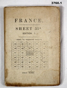
Map - MAPS, FRANCE WW1, 1915 - 1917
(.1) Areas covered by this map, Somain to Valenciennes, Ramillies to Beaudignies. (.2) Areas covered on this map, Bellicourt to Tupigny, St Quentin to Guise. (.3) Areas covered on this map, Heslin to lens, Domart to Baupaume. (.4) Areas covered on this map, Dieppe to Le Quesnoy, Monville to Bonniers. (.5) Same as (.2) Items relate to William Alexander No 502 AIF. Refer 3746.3 for his service details.(.1) Map, France, sheet 51A, Edition 1, scale 1:40,000, Ordnance survey 1916, gauze lined, rear has glossary of terms French to English. (.2) Map, France, sheet 62B, first edition, scale 1:40,000, Ordnance survey December 1917, gauze lined, rear has glossary of terms French to English. (.3) Map France, Lens 11, scale 1:100,000, OSO 1915, gauze lined. (.4) map, France, Dieppe 16, scale 1:100,000, general staff No 2364, War Office 19– gauze lined. (.5) Map, France (same as (.2)(.2 & .5) On rear hand written “124 A.L.T.M.B P179/5maps, france -
 Bendigo Military Museum
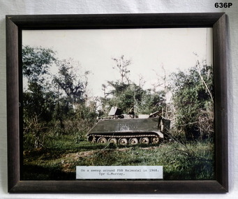
Photograph - PHOTOGRAPH VIETNAM, FRAMED, 1968
Photo taken by Geoff Murray No 3411521, Vietnam 3 Cav Regt 27.11.67 to 22.10.68, Survey Corp 15.10.69 to 15.10.70. Refer 638P.Colour photo, Vietnam showing an APC in the jungle. Label at bottom details time and place, frame is black wood.fsb coral, vietnam, apc’s -
 Bendigo Military Museum
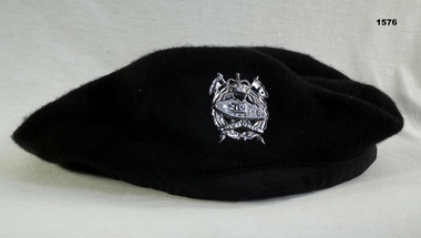
Headwear - BERET & BADGE, 1960’s
Beret and badge issued to Geoffery Charles Murray No 3411521, Vietnam 3 Cav Regt 27.11.67 to 22.10.68, Survey Corp 15.10.69 to 15.10.70.Black Woolen Beret with a Silver Armoured Corp Badge“Kent pure wool large”military-equipment, beret, armoured corp -
 NMIT (Northern Melbourne Institute of TAFE)
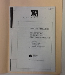
Report: Market Research - NMIT, Market research 1998: Findings and recommendations, 1998
This market research surveyed groups in Industry, the general public, faculty staff, and student focus groups. It makes recommendations for future developments at NMIT. 6 sets of findings and recommendations, each group stapled together. Housed in manilla folder.On cover "Market research 1998", on printed copy "Staffroom".market research, nmit, -
Port Melbourne Historical & Preservation Society
Document - Various items relating to Holy Trinity Anglican Church, Port Melbourne, 1940s
Found among Holy trinity items . Appears to be house to house survey of owner/occupiers/children. Any relationship to church and number of childrenLarge gren/blue folder with darker shade binding and corners. Lists of Holy Trinity and other people .01 confirmation record 14.07.1941 .02 confirmation record 04.09.1946 .03 Finance record 31.12.1977 .04 two sheets of assorted information .05 Listing of Port Melbourne streets, numbers and names of residents - typed .06 Listing of Port Melbourne streets, numbers and names of residents - hand writtenB Bainbridge (in pencil on front cover)religion - anglican (holy trinity) -
 Bendigo Military Museum
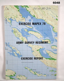
Administrative record - Army Survey Regiment - Exercise Mapex 78, Mar 1979
Exercise Report on exercise Mapex 78. The exercise was designed to test the Army Survey Regiment in an intensive production phase of 30 days duration.A4 soft covered booklet, printed map of part of the Kimberley region of Western Australia on front and back covers, staple boundTop right hand corner of front cover "File on 788-2-14"royal australian survey corps, rasvy, fortuna, army survey regiment, army svy regt, asr -
 City of Greater Bendigo - Civic Collection
Instrument - Gunter Chain, not known
Gunter's chain (also known as Gunter’s measurement) is a distance measuring device used for surveying. It was designed and introduced in 1620 by English clergyman and mathematician Edmund Gunter (1581–1626). It enabled plots of land to be accurately surveyed and plotted, for legal and commercial purposes. The provenance of this particular Gunter Chain is unknown but it is believed to be used either by the City of Bendigo / Sandhurst or the Lands Department locally when measuring and laying out plots and streets locally. A 66-foot (20.1 m) chain divided into 100 links, marked off into groups of 10 by brass rings or tags. Each link is 7.92 inches (201 mm) long. A quarter chain, or 25 links, measures 16 feet 6 inches (5.03 m) also called a a rod (or pole) measure. Ten chains measure a furlong and 80 chains measure a statute mile. city of greater bendigo surveying -
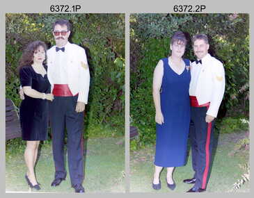 Bendigo Military Museum
Photograph - Army Survey Regiment Summer Ball - Warrant Officer and Sergeant and Guests Arrival, 1995
This is a set of 25 photographs taken at the combined Officer, Warrant Officer and Sergeant’s Mess Summer Ball held at the Army Survey Regiment (ASR), Fortuna Villa on the 25th of February, 1995. The Summer Ball was one of the last large scale formal functions held at Fortuna Villa before ASR’s closure the following year. Photos of personnel and their guests was taken on their arrival near the Pompeii Fountain in the gardens at the front of the main building. The Ball and Dinner was held at the rear of Fortuna Villa in temporary 20’ x 30’ Army tents set up on the roadway in front of the transport compound. SERCO contract staff provided the catering and the ASR’s Other Ranks performed stewarding and kitchen hand duties. Refer to item 6347 for information on the administrative file held in the collection and items 6370.23P, 6371.33P and 6373.36P for additional photographs taken at the Summer Ball.This is a set of 25 photographs taken at the Officer, Warrant Officer and Sergeant’s Summer Ball held at the Army Survey Regiment, Fortuna Villa on the 25th of February 1995. The colour photographs are on 35mm negative film and are part of the Army Survey Regiment’s Collection. The photographs were scanned at 96 dpi. .1) - Photo, colour, 1995. Brian Johnson and partner. .2) - Photo, colour, 1995. Doug Willis and partner. .3) - Photo, colour, 1995. Craig Kellet and partner. .4) - Photo, colour, 1995. Barry and Jenny Hogan. .5) - Photo, colour, 1995. Mick and Margaret Ellis. .6) - Photo, colour, 1995. Peter Tuddenham and partner. .7) - Photo, colour, 1995. Peter and Jo Peterson. .8) - Photo, colour, 1995. Pat and Jeanette Dury-Lane .9) - Photo, colour, 1995. Kevin and Joy Kennedy. .10) - Photo, colour, 1995. Stuart Symonds and his partner Caroline. .11) - Photo, colour, 1995. Jim and Tracy Ash. .12) - Photo, colour, 1995. Graham Wybar and partner. .13) - Photo, colour, 1995. L to R: Graham Wybar and partner, Jan and Kevin Doyle, unidentified guests. .14) - Photo, colour, 1995. Peter and Annette Curtis. .15) - Photo, colour, 1995. John and Tracey Phillips. .16) - Photo, colour, 1995, Barrie Craymer and partner. .17) - Photo, colour, 1995. Rod and Kristin Skidmore. .18) - Photo, colour, 1995. Dale Hudson and partner. .19) - Photo, colour, 1995, Bob Garritty and partner. .20) - Photo, colour, 1995. Steve and Sherri Burke. .21) - Photo, colour, 1995. Brett and Juana Van Leeuwen. .22) - Photo, colour, 1995. Bob and Margaret Thrower. .23) - Photo, colour, 1995. Steve and Helen Drummond. .24) - Photo, colour, 1995. Rhys and Joanne De Laine. .25) - Photo, colour, 1995. Mr & Mrs Townshend, K. Cugley and partner..1P to .25P There are no personnel or civilians identified.royal australian survey corps, rasvy, army survey regiment, army svy regt, fortuna, asr -
 Federation University Historical Collection
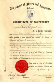
Certificate, Ballarat School of Mines Competency as a Geologist Certificate, o1/06/1911
William Baragwanath became Victorian Government Geologist. Cream coloured vellum certificate with blues Ballarat School of Mines Crest and red seal. It is a Ballarat School of Mines Certificate of Competency as a Geologist made out to William Baragwanath in 1911. The Certificate of Competency included passing examinations in Geology, Mining geology, Mineralogy, Petrology, Mine Surveying and Chemistry.Signed on left 'W. Baragwanath'ballarat school of mines, geology, petrology, mineralogy, surveying, chemistry, baragwanath, martell, frederick martell, maddern, geology alumni, william baragwanath -
Federation University Historical Collection
Booklet, J.H. Pollitt, An Historical Record of Melton, c1961
Melton is a town in Victoria.Orange soft covered booklet of 64 pages. Includes sections on Aborigines, John Bull, exploration, survey, early settler, graves, Melton Roads Board, cemetery, common school, churches, agricultural society, rail, Melton weir, index of students enrolled at the Melton Common School in 1864.william dredge darke, samuel staughton, simon straughton, thomas henry pyke, djerriwarrh, charles williams, richard manning, william oldershaw, william yuille, benjamin porter, john ferris, captain moonlight, viaduct, pennyroyal creek, thomas pyke, toolern toolern creek, melton, keilor station, melton weir, melton common school, john bull, melton coursing cup, melton agricultural society -
Port Melbourne Historical & Preservation Society
Photograph, Aerial Survey of Port Melbourne; December 1945, 2105
Seventeen (17) individual photos were joined together by John Kirby to make a compsite image.Aerial Survey of Port Melbourne; December 1945 Large photograph mounted on foam board. Shows aerial view of Port Melbourne showing its extent from the Bay. Panel on right hand side has key to numbered areas on map . PMHPS logo on top left cornerbuilt environment, local government, natural environment, built environment - industrial, religion - roman catholic church (st josephs), gmh, general motors-holden, rotten row, trotting track, j kitchen & sons pty ltd, wool board storage sheds, government aircraft factory, gaf, commonwealth aircraft corporation, cac, north port oval, brookes lemos ltd, port melbourne fire brigade, former port melbourne market, eclipse theatre, presbyterian church, inner beacon, forsters arms hotel, commonwealth government engine works, st josephs church and school, missions to seamen, centenary bridge, royal australian navy drill hall, mail exchange, gasometers, town pier, robert harper & co ltd, royal australian navy, hmas lonsdale, port melbourne yacht club, pmyc -
Whitehorse Historical Society Inc.
Article, Morack compares favourably, 1992
Nunawading Parks and recreation Services have just completed a survey and found that City of Nunawading's Morack Golf Course compares favourably with similar courses around Melbourne.Nunawading Parks and recreation Services have just completed a survey and found that City of Nunawading's Morack Golf Course compares favourably with similar courses around Melbourne. the course is one of only six which cater for disabled people and provides a professional golfer for private groups, clinics and the disabled.Nunawading Parks and recreation Services have just completed a survey and found that City of Nunawading's Morack Golf Course compares favourably with similar courses around Melbourne.golf, morack golf course, city of nunawading . parks and recreation services, mcdade, denis, mcintosh, david -
 Bendigo Historical Society Inc.
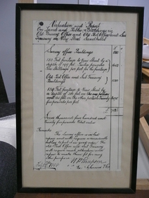
Document - VALUATION AND REPORT ON LAND AND PUBLIC BUILDINGS, 1888
Framed document, valuation and report on land and public buildings vis old survey office and Post Office and sub Treasury in View Street Sandhurst, hand written in black ink and signed N P Simpson Feby 22nd 1888. Under glass in a thin black wooden frame.document, certificate, public buildings -
Bendigo Historical Society Inc.
Map - TARNAGULLA : COUNTY OF BENDIGO, 1959
Map. Tarnagulla, County of Bendigo, Sheet 3, Kingower, Glenalbyn, Inglewood, Loddon River, Derby, Gladstone. Drawn and reproduced at the Department of Lands and Survey, Melbourne, 1959. Price 5/- per sheet. By authority A.C. Brooks, Government Printer, Melbourne. (number 35 in map cupboard 1)A.C. Brooks Government Printer, Melbourne.map, bendigo, tarnagulla -
Bendigo Historical Society Inc.
Map - CORNELLA : COUNTY OF BENDIGO, 13-4-32
Map. Cornella, County of Bendigo, County of Rodney, Colbinabbin, Gobarup, Redcastle, Toolleen, Kangaroo Creek, Cornella Creek. By authority H.J. Green, Govt. Printer. Photo-Lithographed at the Department of Lands and Survey, Melbourne. 13-4-32. Price 2/-. (number 123 in map cupboard 1)H.J. Green, Govt.Printermap, bendigo, cornella -
Bendigo Historical Society Inc.
Map - PANNOOBAMAWM : COUNTY OF BENDIGO, 7-9-15
Map. Pannoobamawm, County of Bendigo, Terrick Terrick East, Wanurp, Pannoomilloo, Bamawm,Turrumberry. By authority Albert J. Mullett, Government Printer, Melbourne. Photographed at the Deptartment of Lands and Survey, Melbourne. By W.J. Butson 7-9-15. Price 1/-. (number 81 in map cupboard 1)W.J. Butson, Government Printer, Melbourne.map, bendigo, pannoobamawm -
Bendigo Historical Society Inc.
Map - JANIEMBER WEST : COUNTY OF BENDIGO, September 1955
Map. Janiember West, County of Bendigo. Loddon River, Janiember East, Powlett, Kinypanial, Jarklan. Welsh's Lagoon. By authority W.M. Houston, Government Printer, Melbourne. Drawn and reproduced at the Department of Lands and Survey, Melbourne, September 1955, Price 5/-. (number 66 in map cupboard 1)W.M. Houston, Government Printer, Melbourne.map, bendigo, janiember west -
Bendigo Historical Society Inc.
Map - KAMAROOKA : COUNTY OF BENDIGO, 29-8-21
Map. Kamarooka, County of Bendigo, Milloo, Warragamba, Minto, Whirrakee, Tandarra, Piccaninny Creek, Dingee. By authority A.J. Mullett, Govt. Printer. Photo-Lithographed at the Department of Lands and Survey, Melbourne by W.J. Butson 29-8-21. Price 1/-. (number 63 in map cupboard 1)A.J. Mullett, Govt.Printermap, bendigo, kamarooka -
Bendigo Historical Society Inc.
Map - BRIDGEWATER : COUNTY OF BENDIGO, 6-10-27
Map. Bridgewater, County of Bendigo, Inglewood, Salisbury, Derby, Leichardt, Yarraberb, Yarrayne, Bullock Creek, Loddon River, Sandhurst and Inglewood Railway. Photo-Lithographed at the Department of Lands and Survey Melbourne by W.J. Butson, 6-10-27. Price 1/-. (number 53 in map cupboard 1)W.J. Butsonmap, bendigo, bridgewater -
Bendigo Historical Society Inc.
Map - BAMAWM : COUNTY OF BENDIGO, November 1954
Map. Bamawm, County of Bendigo. Sheet 2, Pannoobamawm, Diggorra. Elmore to Cohuna Railway Line. Township of Lockington. By authority W.M. Houston, Government Printer.Drawn and reproduced at the Department of Lands and Survey, Melbourne. November 1954. Price 5/- per sheet. (number 52 in map cupboard 1)W.M. Houston, Government Printermap, bendigo, bamawm -
Bendigo Historical Society Inc.
Map - BAGSHOT, COUNTY 0F BENDIGO, 24-5-21
Map, Bagshot, County of Bendigo,Whirrakee, Egerton, Goornong, Ellesmere, Wellsford, Huntly, Reedy Creek, Sandy Creek.Photo-Lithographed at the Dept. of Lands and Survey, Melbourne by W.J.Butson, 24-5-21. Price 1/-.. By authority A.J.Mullett, Govt. Printer,Melbourne. (number 49 in map cupboard 1)A.J.Mullett, Government Printer, Melbourne.map, bendigo, bagshot -
Bendigo Historical Society Inc.
Map - YARRABERB : COUNTY OF BENDIGO, 23-2-15
Map. Yarraberb, County of Bendigo, Salisbury, Yallook, Neilborough, Nerring, Leichardt, Bridgewater. L5373. Photographed at the Department of Lands and Survey, Melbourne by W.J. Butson 23-2-15. Price 1/-.By authority: Albert J. Mullett, Government Printer, Melbourne. (number 16 in map cupboard 1)By authority Albert J. Mullett, Government Printer.map, bendigo, agricultural lands -
 Bendigo Historical Society Inc.
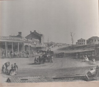
Photograph - GOLDEN SQUARE HIGH SCHOOL COLLECTION: PHOTOGRAPH VIEW STREET SANDHURST
Black and white photograph of an early painting showing View Street Sandhurst in 1859 with Survey and Post Office. Several people walking around , four horse drawn carriages, on the left Henry Jackson store and a row of houses and shops under a portico on the right two double story houses .bendigo, streetscape, view street -
 Bendigo Historical Society Inc.
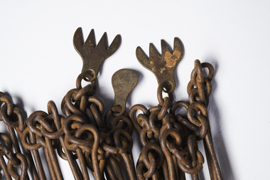
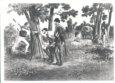
Photograph - WES HARRY COLLECTION: SURVEY PARTY, 1854
Photograph of a drawing depicting a survey party in 1854. In the left foreground there are Two men, one is looking through a theodolite and another is blazing a mark on to a tree with an axe. Two other men are dragging a chain measure. In the background there is a boy standing by a horse and cart. The whole group is in a bush land setting.organization, lands and survey, original survey, surveying, theodilite, chain -
 Bendigo Historical Society Inc.
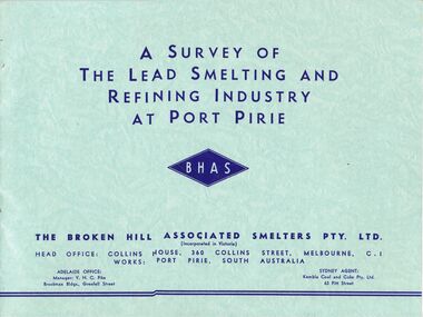
Document - MCCOLL, RANKIN AND STANISTREET COLLECTION: SMELTING, URANIUM, c1955
McColl Rankin & Stanistreet, 4 books: A&B/ A Survey of The Lead Smelting and Refining Industry at Port Pirie published by BHHS, 2 copies. C/Broken Hill Associated Smelters, published by BHAS. D/ Port Pirie Uranium Treatment Plant SA, published by SA Dept Mines.organization, mining, lead smelting smelter uranium port pirie broken hill -
 Bendigo Military Museum
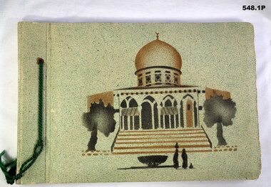
Album - PHOTOGRAPH ALBUM, WWII
The album collection belonged to Jack Smethurst VX28896 Australian Army Survey Regiment (Royal Australian Artillery). Refer 549.4, 550.2, 557, 558.6.548.1P. Green front, picture of mosque, photos of Syria. Green cord on side. MIxture of B&W photos and small postcards. Four loose B&W photos inside front cover. 548.2P. Black cover, silver inlay of David's Tower. Brown cord on spine. Tourist and Australian Army B&W photos. Six loose B&W photos between first and second pages. 548.3P. Black cover, silver inlay of Rachael's Tomb. Brown cord on spine. Two loose photos on back pages. Tourist and Army photos of Libya, Palestine and Syria.books-albums, photography-photographs, middle east, military history, royal australian artillery