Showing 25607 items matching "plenty-township-estate"
-
 Whitehorse Historical Society Inc.
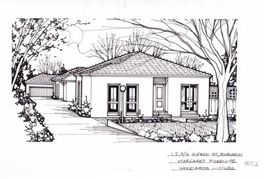
Artwork, other - Ink Line Drawing, 1,2,3/16 Alfred St., Burwood, 1995
A property illustration by Margaret Picken Commissioned by the real estate agency Woodards, Camberwell for the purpose of advertising 1,2,3/16 Alfred St., Burwood for sale in 1995. Made by using Rotring ‘Rapidigraph’ drafting pens with Rotring ink on Rapidigraph polyester drafting film, double matte. The suburb lines are believed to have been redrawn, making this property no longer in Burwood, but located in Glen iris. 1/16 Alfred St., Burwood is listed as having sold for in 1995 for $185,000 Trained as a cartographic draftsman within the mining industry, Margaret Picken is an artist who worked producing property illustrations for real estate agencies in eastern suburbs of Victoria from 1983-2005. Retiring from the industry as technological changes favoured coloured photography over illustrations, and commissioning companies over sole contractors.This artwork is of Historical Significance as a record of local domestic architecture.A black ink line drawing on drafters film by Maragret Picken, of 1,2,3/16 Alfred St., Burwood. Depicted are three one-story rendered houses on one block, one behind the other, situated back from a front lawn with a large tree on the right, and a driveway on the left leading to a garage There to two hole punches just below the upper edge An approximately 1.5cmx0.5 tape reside mark at the centre of the bottom edge A 1cm vertical line of dirty tape residue on the center of the upper edge. 1,2,3/16 Alfred St., Burwood Margaret Picken - 95 Woodards - c'wellwhitehorse historical society, schwerkolt cottage, housing, architecture, margaret picken, burwood, glen iris, house, garden -
 Whitehorse Historical Society Inc.
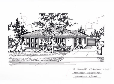
Artwork, other - Ink Line Drawing, Margaret Picken, 13 Medhurst St., Burwood, 1993
A property illustration by Margaret Picken Commissioned by the real estate agency Woodards Blackburn for the purpose of advertising 13 Medhurst St., Burwood in 1993 Made by using Rotring ‘Rapidigraph’ drafting pens with Rotring ink on Rapidigraph polyester drafting film, double matte. The suburb lines are believed to have been redrawn, making this property no longer in Burwood, but located in Burwood East. This property which was built in circa 1960's, is listed as having sold for $130,000 in 1993 Trained as a cartographic draftsman within the mining industry, Margaret Picken is an artist who worked producing property illustrations for real estate agencies in eastern suburbs of Victoria from 1983-2005. Retiring from the industry as technological changes favored coloured photography over illustrations, and commissioning companies over sole contractors.This artwork is of Historical Significance as a record of local domestic architecture.A black ink line drawing on drafters film by Margaret Picken, of 13 Medhurst St., Burwood. Of a one story brick house with driveway to the left leading to a garage. In the foreground is a front lawn with a gumtree. There is a thin reddish 2.5cm mark to the left of the inscription.13 Medhurst St., Burwood Margaret Picken -93 Woodards - B/Burnwhitehorse historical society, schwerkolt cottage, housing, architecture, margaret picken, burwood, house, garden, burwood east -
 Whitehorse Historical Society Inc.
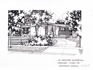
Artwork, other - Ink Line Drawing, Margaret Picken, 25 Hampshire Rd., Forest Hill, 1995
A property illustration by Margaret Picken Commissioned by the real estate agency Woodards Blackburn for the purpose of advertising 25 Hampshire Rd., Forest Hill. This property is listed as having sold for $104,000 in 1996. Since the time of sale in 1996 the house on the property has been demolished and a new house built on the site. Made by using Rotring ‘Rapidigraph’ drafting pens with Rotring ink on Rapidigraph polyester drafting film, double matte. Trained as a cartographic draftsman within the mining industry, Margaret Picken is an artist who worked producing property illustrations for real estate agencies in eastern suburbs of Victoria from 1983-2005. Retiring from the industry as technological changes favored coloured photography over illustrations, and commissioning companies over sole contractors.This artwork is of Historical Significance as a record of local domestic architecture.A black ink line drawing on drafters film by Margaret Picken, of 25 Hampshire Rd., Forest Hill. Depicting in the foreground a horizontal timber plank fence on the left, and a curving driveway on the right leading to a connected carport. In the background is a small house. There are two hole punch holes just right of centre on the upper edge. There is a 0.5x0.5 mark on the top half of the right edge25 Hampshire Rd., Forest Hill Margaret Picken - 95 Woodards B/Burnwhitehorse historical society, schwerkolt cottage, housing, architecture, margaret picken, house, garden, forest hill -
 Whitehorse Historical Society Inc.
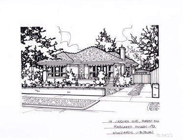
Artwork, other - Ink Line Drawing, Margaret Picken, 14 Jaques Grv., Forest Hill, 1993
A property illustration by Margaret Picken Commissioned by the real estate agency Woodards Blackburn for the purpose of advertising 14 Jaques GVE., Forest Hill, This property is listed as having sold for $157,000 in 1993. The house depicted in this artwork is no longer standing. Having been demolished and a new house built in its place between the time of this artworks creation in 1993 and 2024. Made by using Rotring ‘Rapidigraph’ drafting pens with Rotring ink on Rapidigraph polyester drafting film, double matte. Trained as a cartographic draftsman within the mining industry, Margaret Picken is an artist who worked producing property illustrations for real estate agencies in eastern suburbs of Victoria from 1983-2005. Retiring from the industry as technological changes favored coloured photography over illustrations, and commissioning companies over sole contractors.This artwork is of Historical Significance as a record of local domestic architecture.A black ink line drawing on drafters film by Margaret Picken, of 14 Jaques Grv., Forest Hill, depicting a single story brick house set back from a low fence and front yard, with a driveway on the right. There are two hole punch holes centre near the upper edge.14 Jaques Grv., Forest Hill Margaret Picken- 93 Woodards - B/Burnwhitehorse historical society, schwerkolt cottage, housing, architecture, margaret picken, house, garden, forest hill -
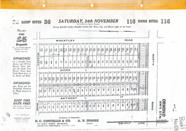 City of Moorabbin Historical Society (Operating the Box Cottage Museum)
Flyer - Brennan's Estate, Ormond - H. C. Costello & Co, 1923 - 1924
Land sales in the Municipality of Moorabbin increased when the train line from the City to Frankston was electrified. Brennan's Real Estate, Ormond 116 home sites and 36 Shop sites was auctioned on three occasions in order to sell building lots that had failed to sell at the previous action.Example of the progress of the Municipality of MoorabbinAdvertising flyers for auction of real estate sales - plan of building blocks for saleBrennan's Real Estate, Ormond 116 home sites and 36 Shop sites was auction on three occasionsnorth road, wheatley road, queen street, anthony street, murray road, h. c. costello & co, a. n. moore, ormond, real estate, auctions -
 Southern Sherbrooke Historical Society Inc.
Map - photocopy, Woodcock & McCormack, civil engineers & architects & surveyors, The Major Estate, Belgrave
A photocopy taken from the original land sale map provided to the society through Karel Coxell of Stockdale & Leggo. The original maps are stored in large bound account books and were originally the propert of McNally Real Estate. The books are held (in 22 A3 sheets. Shows The Serpentine between Government Rd (now Sandells Rd) and Government Rd(now Terrys Ave), Belgrave. Arrows to Belgrave, Sherbrooke Falls, Main Rd and store.land sales, advertisement, real estate subdivision, t. mahoney -
 Eltham District Historical Society Inc
Photograph - Aerial Photograph, Landata, Lower Plenty, Vic, Apr. 1963
Centred on present day Old Eltham Road near Araluen Centre, Lower Plenty bounded by Cromwell Street to north, Yarra River to south, Main Road at Mount Pleasant Road to east and Panorama Avenue to west. Historic Aerial Imagery Source: Landata.vic.gov.au Aerial Photo Details: Project No :486 Project : MELBOURNE (1963) PROJECT Run : 7 Frame : 231 Date : 04/1963 Film Type : B/W Camera : RC8 Flying Height : 5100 Scale : 9600 Film Number : 1805 GDA2020 : 37°44'03"S, 145°07'56"E MGA2020 : 335420, 5822027 (55) Melways : 21 F10 (ed. 42)aerial photo, neil webster collection, 1963-04, araluen, cromwell street, eltham, lower plenty, main road, melway 21f10, mount pleasant road, old eltham road, panorama avenue, yarra river -
 Greensborough Historical Society
Article, Journal, Australian Home Beautiful, Lower Plenty State School LP1295, 20/06/1921o
The Australian Home Beautiful article on the Heidelberg and Eastern Golf Club indicates that its clubhouse comprised two buildings, "Bryn Teg" built by Mrs Thomas, one approximately 1849, the other 40 years later. The club moved into these buildings about 1928. The stables were converted for use in 1921 by Frederick Henry Gilsenan as the Lower Plenty State School No. 1295 which was open from 20/06/1921 to 11/04/1925. Mr. Gilsenan married Margaret Mar Cornall in 1923. They lived in Heidelberg, had a daughter, Verna in 1924. Mr Gilsenan was transferred to Mt Moriac SS No. 1608 in 1925. The handwritten account is written by Verna.Historical significance about the premises of both the Lower Plenty State School and the Heidelberg Golf Club.4 p. photocopied article from Australian Home Beautiful 1 June 1929, with 2p.handwritten history of the school 20/06/1921-11/04/1925 (2 copies) and page of photographs of building and people.lower plenty primary school, gilsenan, frederick henry, heidelberg golf club -
![Advertising Leaflet, Grace Park Electric Station Estate, Watsonia [3], 21/06/1924](/media/collectors/4f729f5697f83e03086015b8/items/5dcfb9c821ea671434edd447/item-media/5dcfb9e821ea671434ededfc/item-fit-380x285.jpg) Greensborough Historical Society
Greensborough Historical SocietyAdvertising Leaflet, Grace Park Electric Station Estate, Watsonia [3], 21/06/1924
Digital copy of auction leaflet for sale of land known as Grace Park Electric Station Estate, Saturday 21/06/1924. Auctioneer Knight & Harwood in conjunction with C. Jessop. This leaflet shows a photograph of the 'Grace Park Railway Station' nearing completion.Digital copy of auction leaflet 1 page. Black and red text on white paper.watsonia, grace park -
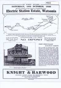 Greensborough Historical Society
Advertising Leaflet, Electric Station Estate; Watsonia; Saturday 16th October 1926, 16/10/1926
This is one of two brochures advertising the auction of the last 50 allotments of the Electric Station Estate, Watsonia, near the new railway station. This brochure contains a locality plan and drawing of the general store. (Refer 4526 for the other brochure for this auction) Auctioneer: Knight & Harwood.One page B & W Photocopy (laminated) of auction brochure, with drawing of general store and locality planwatsonia railway station, watsonia, electric station estate -
 Eltham District Historical Society Inc
Photograph, 14 Stokes Place, Eltham, September 2017 (Advertising material photos; Morrison Kleeman Real Estate), 2017
14 Stokes Place was the home of Peter and Carla Vermey who had migrated to Australia from Holland. The land was purchased in May 1979 and the home built by Peter and Carla Vermey after the developer, Macquarie Builders went bankrupt. Sold October 2017 by Morrison and Kleeman Real Estate. Stokes Place was part of the Stokes Orchard Estate which was developed from the break-up of the the orchard owned by Frank Stokes who lived on the northeast corner of Nyora Road and Eucalyptus Road. His daughter Beryl advised that the Shire had levied a rate assessment on individual parcels of land within the orchard which became unaffordable resulting in its sub-division and sell off. The Stokes Orchard Estate was developed by Macquarie Builders in two stages starting with stage 1 in 1976. Stokes Place was part of Stage 2 in 1979. The Estate was bounded between Nyora Road, Eucalyptus Road, Diosma Road and Stokes Place. The original orchard only just reached the left most portions of Stokes Place and did not go fully up to Diosma, rather to just beyond the extant of Stokes Place. Stokes Place was known within the family as "The Oats" as that is where they grew oats. Frank Stokes moved to Eltham c.1945 after visiting Harold Bird to view his orchard, located diagonally opposite Stokes Orchard from the intersection of Eucalyptus Road, Pitt Street and Nyora Road. It was on Harold Bird's recommendation that Frank purchased the land.The Stokes Orchard Estate collection is typical of housing developments of the late 1970s and 1980s. It was one of the earliest estates in Eltham following the nearby Woodridge Estate development.Digital fileScanned from a print contained in owner's photo album (81 prints in total digitised)stokes place, eltham, stokes orchard, stokes orchard estate, streets, houses, peter and carla vermey -
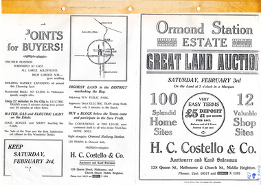 City of Moorabbin Historical Society (Operating the Box Cottage Museum)
Flyer - Ormond Station Estate, Ormond, 1923
At the end of World War One, there was a renewed interest in residential land and a number of estates opened up in the Municipality of Moorabbin.Example of the progress of the Municipality of MoorabbinAdvertising flyer for auction of real estate sales - plan of building blocks for saleOrmond Station Estate, Ormond - Great Land Auction - 100 Home sites 12 shop sites - Auction Saturday 3rd February 1923malane st, foch st, coane st, beatty crescent, ormond, real estate, auction -
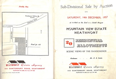 Ringwood and District Historical Society
Flyer - Land Sales Brochure, Sub-Divisional Sale by Auction - Mountain View Estate, Heathmont, Victoria - 1957
Bi-fold pamphlet advertising auction of 20 residential allotments on Saturday, 14th December, 1957, with description of services available and finance terms. Subdivision inclues Orchard Grove and Barnic Road. Agent - Heathmont Estate Agency, 103 Canterbury Road, Heathmont, Telephone WU6808, after hours WF1488. Auctioneer Mr. A.B. Carter. Accompanying Parish of Ringwood survey map with cardboard backing - Part of Crown Allotment 14B, includes handwritten price notations for each allotment. -
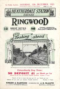 Ringwood and District Historical Society
Flyer, Subdivisional Land Auction Sale Brochures, Heatherdale Station Estate, Ringwood, Vic. - 1923 and 1924
Two double sided multi-folded pages advertising public auction sales of shop sites and residential allotments on Saturday, 15th December, 1923 and Saturday, 2nd February, 1924, including summary of local facilities, services and map showing layout of the estate. Includes a photograph depicting proposed site for first Heatherdale railway station and a panoramic view of Ringwood from the railway level crossing in Heatherdale Road. 1923 and 1924 flyers are identical except for the auction dates printed at the top.Subdivision includes Heatherdale Road, Molan Street, Yallourn Parade, Newman Street, and Madden Street. Agents - Knight & Harwood, 315 Collins Street, Melbourne, Phone 10615, 10616 Central, in conjunction with J.B. McAlpin, Opposite Railway Station, Ringwood. Phone Ringwood 7. Additional cardboard-backed copy of map includes later penciled sales notations for some blocks (VC 5801 refers). -
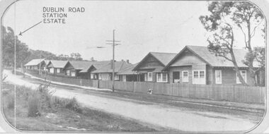 Ringwood and District Historical Society
Photograph, Two images of 1924 Dublin Road Station Estate land sale promotional photograph - War of 1914-18 Soldiers homes on Bedford Road
Typed below photograph, "10 modern villas recently erected alongside the estate". Typed below photograph, "Soldiers Homes, Bedford Road. 1924." Catalogue card reads, "Soldiers homes Bedford Road, looking east from outside shops corner Illoura Ave. War of 1914-18 Soldiers Homes. From land sale brochure." -
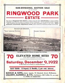 Ringwood and District Historical Society
Flyer, Sub-divisional auction sale advertisement - Ringwood Park Estate, Ringwood, Vic. - 1922
Folded double-sided page with black and white photographs of local views with black and red print advertising auction sale on Saturday 9th December, 1922, - 70 residential home sites, including terms of sale, locality map, and description of local facilities and services. Subdivision includes Wonga Road (later Loughnan Road), William Street, Andrew Street, and Harrison Street. Vendors Solicitors - Rigby & Fielding, 60 Market Street, Melbourne. Estate Agents - Keogh & King, 70 Elizabeth Street, Melbourne, Telephone 6938. Auctioneer - Cranny, Sambell & Co., 325 Collins Street, Melbourne, Telephone Central 5067 and 5077. -
 Eltham District Historical Society Inc
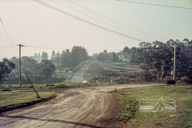
Slide, Main Road, Lower Plenty, 25 Jul 1973
This section of Main Road was known by locals as the "Windy Mile" due to its many little wists and turns. It was also the setting for Billy Cart derbies held on special occassions such as the Eltham Easter Gymkhana at Eltham Lower Park. Contestants would line up and race each other down the hill to the finish line at Bolton Street. Main Road, Lower Plenty underwent substantial changes when it was duplicated with the road becoming two lanes each way and split level due to the cross gradient. This particular section running down the hill from Panorama Avenue to Bolton Street with its twists and turns had many of them straightened out during the road widening constuction work.35 mm colour positive transparency Mount - Agfacolor Service (Blue)main road, infrastructure, lower plenty, roads, windy mile -
![Advertising Leaflet, Grace Park Electric Station Estate, Watsonia [2], 21/06/1924](/media/collectors/4f729f5697f83e03086015b8/items/5dcfb86d21ea671434eca90c/item-media/5dcfb88e21ea671434ecd037/item-fit-380x285.jpg) Greensborough Historical Society
Greensborough Historical SocietyAdvertising Leaflet, Grace Park Electric Station Estate, Watsonia [2], 21/06/1924
Digital copy of auction leaflet for sale of land known as Grace Park Electric Station Estate, Saturday 21/06/1924. Auctioneer Knight & Harwood in conjunction with C. Jessop. This leaflet features block plans and a railway line illustration showing the site of 'Grace Park Railway Station'.Digital copy of auction leaflet 1 page. Black and red text on white paper.watsonia, grace park -
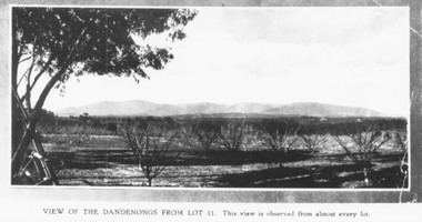 Ringwood and District Historical Society
Photograph, Mullers orchard, Heathmont. Looking east from cnr. Canterbury and Dickasons Rds. "Charm View Estate" - 1926
Printed below photograph, "View of the Dandenongs from Lot 11. This view is observed from almost every lot". Written on back of a photograph, "Photo taken from sub. div. plan land sales. Charm View Estate, Heathmont, 1926?" Another copy reads, "Mullers orchard, Heathmont. Taken from cnr. Canterbury and Dickasons Rds. Looking east - 1926". -
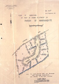 Ringwood and District Historical Society
Document - Folder, Pembroke Estate Subdivsion, Ringwood, Victoria - 1964
Manilla folder containing certified copy of Plan of Subdivision dated 2nd September, 1964 - Part of Crown Allotment 29 Parish of Warrandyte, and separate A4 size copy of plan with handwritten 1966 pricing notations. Subdivision includes allotments on Pembroke Court off Loughnans Road, Ringwood.Surveyors - Kirkpatrick & Webber, Civil Engineers & Town Planners, 225 Maroondah Highway, Ringwood, Telephone 8700321. Agents - C.E. Carter & Son RESI., 126 Whitehorse Road, Ringwood (Phone) 87-6024, 87-6830, 870-2519. Folder covernote by Richard Carter - Carter Real Estate - "Vendor - Dale, Plan of Subdivision 68868, sold 23 July 1966." -
 Eltham District Historical Society Inc
Photograph, Russell Yeoman, Para Road, c.1969, 1969c
Looking north from behind the Lower Plenty shops at Main Road and Para Road.Digital file only; created from original colour positive slide transparencystreets, lower plenty, para road, russell yeoman collection -
 Eltham District Historical Society Inc
Slide, Quinn Estate, Buena Vista Drive, Montmorency near school looking northwest, c.Oct. 1980
One of a series of images of roads and infrastructure focussed on the Quinn Estate in Montmorency taken by Eltham Shire Council Planning and Engineering officers. They provide perspective of the changes in housing styles and road development that began sweeping in from the mid 1970s with increasing urbanisation of what was once more outlying suburbs and regions.35 mm colour positive transparency Mount - Kodak Kodachrome CardProcessed Oct 1980housing estate, infrastructure, montmorency, quinn estate, roads -
 Eltham District Historical Society Inc
Slide, Quinn Estate looking east along Cressy Streett, Montmorency before Quinn Way, c.Oct. 1980
One of a series of images of roads and infrastructure focussed on the Quinn Estate in Montmorency taken by Eltham Shire Council Planning and Engineering officers. They provide perspective of the changes in housing styles and road development that began sweeping in from the mid 1970s with increasing urbanisation of what was once more outlying suburbs and regions.35 mm colour positive transparency Mount - Kodak Kodachrome CardProcessed Oct 1980infrastructure, montmorency, cressy street, housing estate, quinn estate, quinn way, roads -
 Eltham District Historical Society Inc
Slide, Quinn Estate from Sackville Street looking west to 'T-bowl' near Main Road, Montmorency, c.Oct. 1980
One of a series of images of roads and infrastructure focussed on the Quinn Estate in Montmorency taken by Eltham Shire Council Planning and Engineering officers. They provide perspective of the changes in housing styles and road development that began sweeping in from the mid 1970s with increasing urbanisation of what was once more outlying suburbs and regions.35 mm colour positive transparency Mount - Kodak Kodachrome CardProcessed Oct 1980roads, housing estate, infrastructure, main road, montmorency, quinn estate, sackville street, t-bowl -
 Eltham District Historical Society Inc
Slide, Quinn Estate, looking northeast along Sackville Street, Montmorency near no. 12, c.Oct. 1980
One of a series of images of roads and infrastructure focussed on the Quinn Estate in Montmorency taken by Eltham Shire Council Planning and Engineering officers. They provide perspective of the changes in housing styles and road development that began sweeping in from the mid 1970s with increasing urbanisation of what was once more outlying suburbs and regions.35 mm colour positive transparency Mount - Kodak Kodachrome CardProcessed Oct 1980infrastructure, housing estate, montmorency, quinn estate, roads, sackville street -
 Eltham District Historical Society Inc
Slide, Quinn Estate looking east along Sackville Street just prior to Quinn Way, Montmorency, c.Oct. 1980
One of a series of images of roads and infrastructure focussed on the Quinn Estate in Montmorency taken by Eltham Shire Council Planning and Engineering officers. They provide perspective of the changes in housing styles and road development that began sweeping in from the mid 1970s with increasing urbanisation of what was once more outlying suburbs and regions.35 mm colour positive transparency Mount - Kodak Kodachrome CardProcessed Oct 1980roads, housing estate, infrastructure, montmorency, quinn estate, quinn way, sackville street -
 Eltham District Historical Society Inc
Slide, Quinn Estate near Sackville Reserve, Montmorency, c.Oct. 1980
One of a series of images of roads and infrastructure focussed on the Quinn Estate in Montmorency taken by Eltham Shire Council Planning and Engineering officers. They provide perspective of the changes in housing styles and road development that began sweeping in from the mid 1970s with increasing urbanisation of what was once more outlying suburbs and regions.35 mm colour positive transparency Mount - Kodak Kodachrome CardProcessed Oct 1980quinn estate, housing estate, infrastructure, montmorency, roads, sackville reserve, sackville street -
 Eltham District Historical Society Inc
Slide, Quinn Estate, Reichelt Avenue near Riverina Road, Montmorency, c.Oct. 1980
One of a series of images of roads and infrastructure focussed on the Quinn Estate in Montmorency taken by Eltham Shire Council Planning and Engineering officers. They provide perspective of the changes in housing styles and road development that began sweeping in from the mid 1970s with increasing urbanisation of what was once more outlying suburbs and regions.35 mm colour positive transparency Mount - Kodak Kodachrome CardProcessed Oct 1980housing estate, infrastructure, montmorency, quinn estate, reichelt avenue, roads -
 Eltham District Historical Society Inc
Slide, Quinn Estate, Buena Vista Drive, Montmorency near school looking northwest, c.Oct. 1980
One of a series of images of roads and infrastructure focussed on the Quinn Estate in Montmorency taken by Eltham Shire Council Planning and Engineering officers. They provide perspective of the changes in housing styles and road development that began sweeping in from the mid 1970s with increasing urbanisation of what was once more outlying suburbs and regions.35 mm colour positive transparency Mount - Kodak Kodachrome CardProcessed Oct 1980housing estate, infrastructure, montmorency, quinn estate, roads -
 Eltham District Historical Society Inc
Slide, Quinn Estate looking west along Cressy Street, Montmorency, c.Oct. 1980
One of a series of images of roads and infrastructure focussed on the Quinn Estate in Montmorency taken by Eltham Shire Council Planning and Engineering officers. They provide perspective of the changes in housing styles and road development that began sweeping in from the mid 1970s with increasing urbanisation of what was once more outlying suburbs and regions.35 mm colour positive transparency Mount - Kodak Kodachrome CardProcessed Oct 1980cressy street, housing estate, infrastructure, montmorency, quinn estate, roads