Showing 23428 items matching " john a"
-
 Flagstaff Hill Maritime Museum and Village
Tool - Plough, Syracuse Chilled Plow Co, 1876-1900
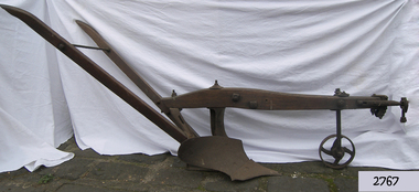
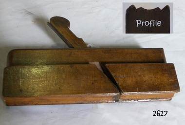
The Syracuse Chilled Plough Company was created in 1876 and specialised in the manufacture of agricultural ploughs. Harry Wiard invented the chilling process in plough manufacture. The company was originally founded as the Robinson Chilled Plough Company in 1876 and changed its name 3 years later. At its peak, in the early 20th century. The company made more than 100,000 horse-drawn ploughs and road scrapers of various designs that were sold from the Syracuse plant each year and exported around the world. The company slogan of the day was, “The sun never sets on a Syracuse plough." Eventually, other farming implements were added to the line. The company employed more than 300 people in its local plant, which covered a square block on the cities Near West Side. In 1910-11, Deere and Company began expanding its holdings, and with the success of the Syracuse Chilled Plough Company, Deere sought to acquire the company. The management of the Syracuse operation after John Deere took over remained in the hands of Wiard and Chase, and the manufacturing operations were left in Syracuse. The only change from previous Syracuse operations was the selling of the companies products through Deere retail outlets instead of directly to the trade. The factory in Syracuse continued to produce ploughs until 1955. The subject item in the Flagstaff collection is an early model Syracuse Chilled plough with a wooden beam frame it is very much lighter in weight and was adapted to work sandy or light loamy soil. This plough has a sloping landside, which tends to keep the clods and dirt from falling into the furrow, making the ploughman's work much more comfortable and easy. This design was made in eight sizes for both right and left-handed ploughing and became very popular in the far West and South of the USA. Note: The definition of a chill plough means : a plough having the share and mould-board of chilled semi steel or cast iron.The subject item is believed to be a very early plough given its wooden beam frame and was made before 1900 probably around 1880. This makes it a significant example of the types of plough that early settlers were using in Victoria. There would not be very many of this type of vintage plough left with a wooden beam and frame, making it today a desirable collector's item. Syracuse Wood Beam Chilled single furrow plough metal wheel in front. Syracuse Chiller Co Syracuse & 50 L stamped on ploughshare.flagstaff hill, warrnambool, shipwrecked-coast, flagstaff-hill, flagstaff-hill-maritime-museum, maritime-museum, shipwreck-coast, flagstaff-hill-maritime-village, plough, syracuse chiller co, chiller plourh, farm equipment, furrow -
 Flagstaff Hill Maritime Museum and Village
Instrument - Navigational Sextant, 1882-1890
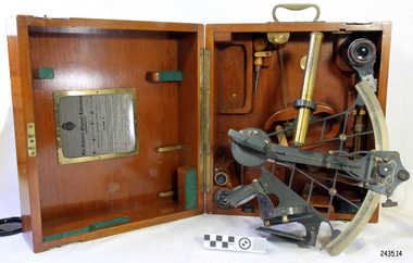
A sextant is an astronomical instrument used to determine latitude and longitude at sea by measuring angular distances, especially the altitudes of the sun, moon, and stars. It is a doubly reflecting navigation instrument and used mainly by sailors to measure the angular distance between two visible objects. The name comes from the Latin sextans, or “sixth part of a unit,” because the sextant’s arc can be 60° or 120° of a circle depending on the model used. The primary use was to measure the angle between an astronomical object and the horizon for the purposes of celestial navigation. The estimation of this angle is known as sighting or shooting the object, or taking a sight. This angle and the time when it was measured is used in order to determine Greenwich Mean Time and hence longitude. Sighting the height of a landmark on land can also give a measure of distance from that object. History: The development of the sextant was as an improvement over the octant, an instrument designed to measure one's latitude. The octant was first implemented around 1731-present but can only measure angles up to 45°. As larger angles were needed to allow the measurement of lunar objects - moon, stars and the sun - at higher angles, the octant was superseded by the sextant. The sextant is a similar instrument but better made and allows larger angles from 60° to 120°. This improvement allows distances to be accurately calculated thereby giving longitude when used with a chronometer. The sextant was derived from the octant in 1757, eventually making all previous instruments used for navigational positioning obsolete. The sextant had been attributed to by John Hadley (1682–1744) and Thomas Godfrey (1704–1749), but reference to the sextant was also found later in the unpublished writings of Isaac Newton (1643–1727). Earlier links can be found to Bartholomew Gosnold (1571–1607) indicating that the use of a sextant for nautical navigation predates Hadley's implementation. In 1922, the sextant was modified for aeronautical navigation by Portuguese navigator and naval officer Gago Coutinho. It should be noted that the octant and quadrant are in the same family as they were, and all are, regarded as sextants. The sextant is representative of it's type and although not fully complete it demonstrates how 18th,19th and 20th century mariners determined their latitude and longitudinal to determine their position on a chart, allowing them to navigate there way across the world's oceans. It also demonstrates the skill and workmanship of the early instrument makers that operated scientific instrument businesses from London and other areas of England to provide most of the navigational instrumentation used by commercial and military navies of the time.Sextant with square, fitted box of polished wood, "Hezzanith" brand. Box contains many parts for the sextants use. On certificate "Heath & Co, London. Sextant Number Y 822". Catch on lid "DEFIANT LEVER" and "PATENT NUMBER 187.10". Maker's certificate is attached to the inside of the box.flagstaff hill, warrnambool, shipwrecked-coast, flagstaff-hill, flagstaff-hill-maritime-museum, maritime-museum, shipwreck-coast, flagstaff-hill-maritime-village, sextant box, sextant, hezzanith, heath & co, navigational instrument, george wilson heath, astronomical instrument, instrument manufacturers, scientific instrument, navigation, celestial navigation, octant, quadrant, lunar navigation -
 Flagstaff Hill Maritime Museum and Village
Tool - Wood moulding Plane, Christopher Gabriel, 18th Century
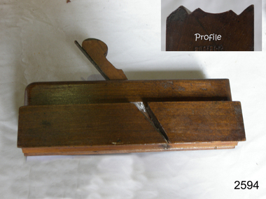
The story of Christopher Gabriel born on April 2, 1746, in Falmouth England is a tale of a poor boy who made good. Shortly before he turned thirteen years of age in 1759 he was apprenticed to a local master carpenter, recorded as a Mr Barnicot the master trained his apprentice well as we can assume by Christopher's later successes. The apprenticeship ended in 1766 after seven years when Christopher reached twenty. Then in 1768, he relocated to London walking the two hundred miles from Falmouth carrying his possessions in a sack. He no sooner arrived in London when he met Alice Trowell who became his wife in March 1769. They set up house on Albermarie Street Clerkenwell and by the first of 1770, Gabriel had begun his business of plane making. It has been speculated that Gabriel took over the shop of John Cogdell aided with an investment from his in-laws of 131 pounds. He went on to prosper as a plane maker and lumber merchant over the next forty years. His business did well and in 1774 Gabriel moved to a house in Golden Lane, London and 1779 moved again to a home in Ould Street London. By now Gabriel was making a name for himself and his business at this time was located at 32 Banner Street Golden Lane, the following year he purchased another home in Banner Street and 1793 purchased the house next door. At the time of his death in 1808, he owned twenty-seven houses and commercial building. Christopher Gabriel s descendants became quite prominent in England and his grandson, Sir Thomas Gabriel became the Sheriff of London and Middlesex in 1859 and the Lord Mayor of London 1866 and 1867. Gabriel was an extremely prolific plane maker with a lot of examples made in the 18th century can still be found today. He made good quality tools and was an innovator of several new plane designs. A vintage tool made by a well-known plane maker, this item was made commercially for firms and individuals that worked in wood and needed a tool that could give a decorative finish to timber. These planes came in various shapes and sizes to achieve a finish to timber surfaces and came in many sizes. A significant Christopher Gabriel plane from the mid to late 18th century that after 200 years can still be used today. Planes made by Gabriel are eagerly sought after by collectors. The tool gives us a snapshot of how furniture and other finishes were created on timber by the use of cutting edged hand tools. Tools that were themselves hand made shows the craftsmanship used during this time not only to make a tool such as the subject item but also the craftsmanship needed to produce a decorative or even finish that was needed for the finishing of timber items. Plane Moulding Reverse Ogee with two squares type Maker stamped Gabriel also stamped JB & No 9flagstaff hill, warrnambool, shipwrecked-coast, flagstaff-hill, flagstaff-hill-maritime-museum, maritime-museum, shipwreck-coast, flagstaff-hill-maritime-village -
 Christ Church Anglican Parish of Warrnambool
Memorial window: William RUTLEDGE, "BY THY CROSS AND PASSION GOOD LORD DELIVER US""
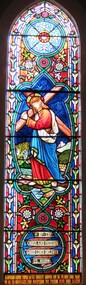
William Rutledge [born 1806, Ireland] was a self-made, larger-than-life man who involved himself prominently in business, municipal, political, community and social aspects of life. Eldest son of James and Martha [nee Forster], William arrived in Australia from Ireland in 1829 and within six years had sufficiently established himself to purchase land in New South Wales. He married Eliza Kirk in Sydney in august 1840. They had two sons and five daughters. In 1843 he began his association and life in Port Fairy and soon became prominent and influential in almost all aspects of that developing town. His interests encompassed mercantile, civic, pastoral, shipping, importing, exporting, immigration, politics and social aspects with in the district and colony. He was a major contributor to the building of St John’s Anglican Church, Port Fairy. He acquired three special surveys with historical importance in Victoria. In south west Victoria that interest being especially the Farnham Survey of 5120 acres between Dennington and Tower Hill/Killarney. This was farmed by immigrant tenant and lessee farmers, some of whom were brought to the Australia at William Rutledge’s own expense and by whom he was considered a kind and considerate landlord. His endeavours were not without failures and in 1862 his Port Fairy Company failed with debts of over £170,000. This debt was redeemed in full within a year. According to reported accounts, William Rutledge had a tempestuous manner with an “explosive” temper, although he did not hold grudges. This is countered by accounts of his kindness, generosity, honesty and practical, progressive outlook in all his undertakings. After the failure and closure of his Company, William Rutledge moved to his property at Farnham Park near Warrnambool where he concentrated his interest in breeding sheep and horses. Throughout his life his home was reputed to be convivial and hospitable. William Rutledge died at Farnham Park on June 1st, 1876. William Rutledge's place in the history of settlement in south west Victoria gives importance to this memorial.Stained glass window, south wall, main nave, depicting Jesus bearing the Cross. The background is quite floral. A medallion shape holds the title as printed on a ribbon: "By thy cross and passion good Lord deliver us".In Latin: In Memoriam Gulielmi Rutledge qui A.D. MDCCCVI underimo ante Kal: Feb: natus vitam posuit/ Kal: Jun: MDCCCLXXVI Filae amantissimae hanc fenestram pietatis indirio posueruntrutledge, william rutledge, farnham survey, port fairy, christ church warrnambool -
 Eltham District Historical Society Inc
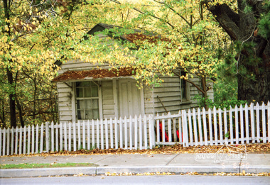
Photograph, Fay Bridge, Ruins beside the Diamond Creek at Wattle Glen, 13 October 2016
The newly constructed Diamond Creek Trail from Diamond Creek to Wattle Glen completed in February 2021 winds around these ruins just pass the high transmission power lines near Herberts Lane and Collard Drive From Jean Verso, Nillumbik Historical Society, 15 April 2021 William Wandless Herbert bought the surrounding 100 acres in 1852. He was a native of Northumberland and the Scottish Borders who arrived in Melbourne in 1847. The house on the top of the mound would have been built not long after he bought the land; the farm was named "Greenhills". He married Elizabeth Wilson, daughter of John Wilson who had been in Diamond Creek since about 1846. Their first child was born in 1854 so there would be some form of dwelling from about that time. They had eight children who all survived to a good age. His will describes the house as part stone and part wood and of four rooms. Nillumbik Historical Society (NHS) believe it was one of the earliest if not the earliest house, in this part of the district. The remains of the stone house foundations are on top of the mound (photos on the VHD page) and the barn walls are on the north and to the east side of the mound. NHS is not sure how much or which part of the surrounding area was covered by the barns but they were large enough to hold dances after the race meetings that were held in the late 1880's on the adjacent creek flats. It would make sense with the lay of the land that they covered some of the ground to the north and east and used for farm storage, packing sheds for their apple and pear orchards and also for supporting the Nillumbik Gold Mine the family worked to the north up the gully. The path that comes down the gully and runs into the trail goes past the mine site which was on the west side of the gully a couple of hundred metres up from the flats. Heritage Victoria link for the site - https://vhd.heritagecouncil.vic.gov.au/places/12203fay bridge collection, 2016-10-13, diamond creek, diamond creek trail, ruins, wattle glen, william wandless herbert, greenhills, elizabeth wilson -
 Eltham District Historical Society Inc
Document - Property Binder, 801 Main Road, Eltham
1. Plan: Henry Dendy's Eltham Land 1857-1867: showing Diamond Creek, Bridge Street, Maria Street now Main Road, John Street, Pitt Street, St Margaret's Church 1861, and Eltham Community Centre 1987. 2. Photocopy extract from "Henry Dendy and his emigrants" by L A Schumer, re Portions 12 and 13, Parish of Nillumbik. 3. The President and Councillors of the Shire of Eltham request the pleasure of ____ at the Official Opening of the Eltham Community Centre, Cnr Main Road and Pitt Street, Eltham by the Honorable R.J. Hamer E.D., M.P., Premier of Victoria on Saturday, 22nd April, 1978 at 3.30pm 4. Souvenir Program, Opening of Eltham Community Centre 22 April 1975. 5. Invitation to attend Official Opening of Eltham Community Centre by R J Hamer, Premier of Victoria, 22 April 1975. 6. Flier for Eltham Reception and Conference Centre, photographs of interiors during events. 7. Newspaper article: Eltham buries present for the future, Diamond Valley News 19 November 1985 Eltham, photograph of burying time capsule outside Eltham Community Centre, photograph of Bill Baker and Sid Brown outside old blacksmith shop the original site of Eltham town centre. 8. Letter Peter Butler Shire of Eltham to Eltham District Historical Society, 6 July 1987, detailing process for naming of the halls at the Eltham Community Centre.6 July 1987. 9. Plan of Main Road Eltham - it depicts buildings and occupiers from Pitt Street to Luck Street in the first half of the 20th century. This plan was compiled as a joint efforts by members of the Shire of Eltham Historical Society at a general meeting in Eltham during the 1980s. Newspaper article: Swimming pool and community centre receive major revamps, Diamond Valley Leader, 21 October 2015.main road, eltham, eltham community centre, henry dendy, eltham reception and conference centre, bill baker, sidney brown blacksmith, tme capsule, arthur street, babe taylor house, bakery, boarding house, bradley house, bridge street, brown blacksmith, burgoyne's shop, cockcrofts store, commercial bank of australasia, david lyon house, davis, dr cordner, dr hall, dudley street, eltham hotel, eltham obelisk, eltham war memorial, garnet burges, graham, hawker, henry street, john lyon, len perron, luck street, lyons garage, map, mechanics insitute, monteith house, mrs morris shop, our lady help of christian’s primary school, panther place, pitt street, prior street, shillinglaw cottage, shops, stones mixed shop, websters house, wesleyan methodist church, york street -
 Eltham District Historical Society Inc
Photograph, The Stokes family home and orchard blanketed with snow, corner Nyora and Eucalyptus roads, Eltham, Winter 1951, 1951
Taken from outside the family home on the southest corner of the intersection of Nyora Road and Pitt Street with Eucalyptus Road. Frank Stokes first traveled to the district by train in 1944 to find land with the intention to establish an orchard. By chance he met Arthur Bird of Bird Orchard (bounded by Pitt Street, Eucalyptus Road and Wattle Grove) and they got talking over their common interest. Arthur put Frank up for the night and pointed out the land, part of Crown Allotment 15, Section 5, Parish of Nillumbik (CA15) somewhat diagonally opposite Bird Orchard. Frank bought the land and for the next two years would travel by train from Melbourne to Eltham every weekend establishing Stokes Orchard and building a home for his family, which they eventually moved into in 1946. Marjorie North remembered well the winter of 1951, when she took children, including son John together with the Shallard and Squire children “in the Austin A40 up the Main Rd., Eltham to farmer Bell’s property alongside the Eltham College. They were able to make a snow man and throw snowballs. (Diamond Valley News, August 5, 1986.p.42) In the mid 1970s the Shire of Eltham divided the orchard up into numerous rate-able parcel lots, which became affordable for Frank. As a consequence Stokes Orchard was turned into a housing development by Macquarie Builders and marketed as the Stokes Orchard Estate in two stages; Stage 1 encompassing Scarlet Ash Court, Ironbark Close and Peppermint Grove bounded by Nyora and Eucalyptus roads c.1976 and Stage 2 encompassing Stokes Place, Orchard Way, The Crest and The Lookout bound by Nyora and Diosma roads c.1979. The development of Orchard Way, The Crest and The Lookout did not proceed as planned due to the lack of the sewer along Diosma Road and so many of the proposed lots were incorporated into five-acre parcels instead.Representative of the orchard growing areas of Eltham. One of the rare times it has snowed in Eltham.Digital file only - Digitised by EDHS from a scrapbook (containing commercially printed photos of digital scans) on loan from Beryl Bradbury (nee Stokes), daughter of Frank Stokes.1951, beryl bradbury (nee stokes) collection, eltham, nyora road, eucalyptus road, snow, stokes family home -
 Eltham District Historical Society Inc
Film - Video (VHS), IMP Productions, The Shire of Etham - The Evergreen Shire (Series 69, Item 4), c.1985
Shire of Eltham Archives: Series 69, Item 4 This video was produced for the Shire of Eltham by IMP Productions and provides a description of the shire, 277 square km on a north/northeast axis, some 25 km northeast of the centre of Melbourne with a population of around 40,000. Scenes include Yarra River, rural settings and urban settings, housing estates, Shillinglaw Cottage, Pigeon Bank at Kangaroo Ground, the Eltham Railway Trestle Bridge with reference to the fight by locals in the 1970s to save it from replacement, Montsalvat, mudbrick making and its use as a building material, the use of mudbrick in the Eltham Community Centre blending harmoniously with the environment. Emphasises people living in the area due to the qualities of life provided. Also the Living and Learning Centre, St Andrews Markets and other local markets, the Eltham Leisure Centre, cricket and horse riding at Eltham Lower Park, the Infant Welfare Centre (part of the Eltham War Memorial), how residents are mindful of protecting their historical heritage, the CBA bank and Allwood House at Hurstbridge, Tracey Naughton about the Eltham "As we are" Community Banner project and the “River of Life banner”, the Parks and Gardens office in the former Police Residence building (now the Local History Centre), Alistair Knox Park, road planning and types of roads, tree canopy, Peck's Dam, green carparks, road drainage, Gordon Ford's garden and natural landscapes, and Were Street shops in Montmorency. Planning for shopping facilities and carparks with a population of 40,000 growing to 55,000, Arthur Street Mall and carpark, local village feel in the shopping centre. Councillors and Council staff featured include Mary Grant, Bob Manuell, Rodney Roschellor, John Cohen, Alan Baker. Also scenes of Commercial Place, Diamond Valley Railway, Eltham Galley, Riverclay and canoeing on the Yarra intermingled with images of the shire from the Shire of Eltham Pioneers Photograph collection.VHS Video cassette Converted to MP4 file format 00:11:56; 79MBshire of eltham, video recording, shire of eltham archives, alistair knox park, allwood house, arthur street, arthur street mall, bob manuell, canoeing, carparks, cba bank, commercial place, council staff, councillors, cr. mary grant, cricket, diamond valley railway, eltham community banner project, eltham community centre, eltham galley, eltham leisure centre, eltham living and learning centre, eltham lower park, eltham railway trestle bridge, eltham war memorial, gordon ford garden, horse riding, housing estates, hurstbridge, infant welfare centre, john cohen, kangaroo ground, local history centre, montmorency, montsalvat, mudbrick, parks and gardens, peck's dam, pigeon bank, police residence, river of life banner, riverclay, road drainage, road planning, rodney roschellor, shillinglaw cottage, shire of eltham pioneers photograph collection, st andrews market, tracey naughton, tree canopy, were street, yarra river, alan baker -
 Bendigo Military Museum
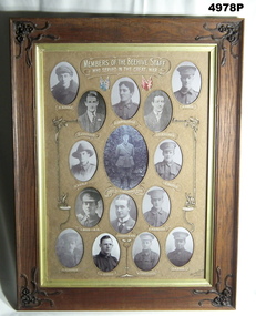
Honour Board - BEEHIVE STORE HONOUR BOARD WW1, Bee Hive Staff, Photographic Honour Roll Members of the Beehive Emporium Staff who served in the Great War WW1, c1918-1925
This honour roll was found in poor condition in a district antique shop. It was fully restored by an enthusiastic local lady, It was presented to the Soldiers Memorial Military Museum on 20 April 2022. The Museum is now known as the Bendigo Military Museum. The Beehive was a major store in Pall Mall Bendigo, the Main Street through the centre of the City. Names on the roll. Top row, E. Buddle, Edgar Peter No 4450 14th reinforcements 6th BN. R Jenkins, Reginald Claude No 4526 14th reinforcements 6th BN. H Crowalladar. Spelt wrong, actually Thomas Henry Cadwallader No 4160 13th Reinforcements 7th BN KIA 18.8.1916. J. A. Williams, John Arnold No 9797 16th reinforcements 2nd Fld Amb. J. Holl, James Thomas No 2432 5th reinforcements 60th BN. 2nd row, N. Veale, (Veal) Norman Joseph No 2070 5th reinforcements 14th BN Major Robert Oswald Henderson D.S.O, 38th BN HQ, KIA 29.9.1918. Rank at death Lt Colonel. P, Buddle, Thomas Percy No 3359 9th Reinforcements 58th BN KIA 27.4.1918. 3rd row. C. Wood MM, Charles No 2453 5th Reinforcements 24th BN, MM 20.9.1917, Bar to MM 14.6.1918. T. Henderson MM, Thomas Richard, 15th Reinforcements 5th BN (2nd Lt). Awarded MM after joining the Canadian Army. F. Marriot, Frederick No 1897 13th Reinforcements 4th LH Regt, MM 2.11.1917 4th row. N Meagher, Norman Bernard No 43 38th BN HQ. G.Speedy, George Thomas No 21718 General reinforcements Army medical Corp 1917. W. Trebilcock, William Edward No 55239 5th General Reinforcements (Vic) 1918. C. P. Fisk, Charles Reginald No 55371 6th General Reinforcements (Vic) 1918. "MM" Military Medal "DSO" Distinguished Service Order The frame is a flat faced hardwood timber, varnished. Each corner has a decorative scroll work of leaves and flowers. They are dark brown colour. There is a gold rim around the inside of the picture frame. Inside are 15 oval openings, in which are black and white portraits of WW1 soldiers. The writing and captions are in white paint. Each name has a decorative loop around it. There are two sets of National flags painted near the top. Red and blue tints.ww1, honour roll, beehive -
 Federation University Historical Collection
Article - Article - Women, Ballarat School of Mines: Women of Note; Jeanette Perkins, First Female Geology Student, (1927 - )
Jeanette Perkins was born in 1927 at Ballarat. She attended Alfredton State School and Pleasant Street State School before completing her secondary schooling at Ballarat High School (BHS). During her later years at BHS Perkins decided that she wanted to become a geologist, but was ineligible for university when she failed Leaving Certificate maths. She attended an interview with the principal (Heseltine) at the Ballarat School of Mines (SMB) and announced that she wanted to be a geologist. Heseltine was, according to Perkins, aghast: he informed her that there had never been a female geologist at SMB and they didn't want one. But Perkins persisted. Only then did Heseltine reluctantly enrol her in the School's Applied Chemistry Course which offered the most geological subjects, moreover, it was the only one he considered available to a 'mere' female. After graduating Perkins was employed as a metallurgical chemist with M.B. Johns Valves, Ballarat. In 1949 she married Alfred Watson. In 1951 Jeanette and Alf Watson moved to Melbourne where she commenced work as a metallurgical chemist at the Maribyrnong Ordnance Factory while studying geology part time: Alf returned to study at the University of Melbourne. Once again, Watson set a precedent by becoming the first female student to study geology part-time at the Melbourne Technical College. Increasing demands brought about by her growing family, she turned to part-time lecturing second and third year stratigraphy and palaeontology at RMIT. In 1957 the Watsons moved to the Mary Kathleen Uranium Mine in NW Queensland where he was appointed electrical design engineer. After their return to Melbourne in 1960, Jeanette taught herself to SCUBA dive and quickly developed a passion for the sport and the marine environment. She taught senior science to secondary students for 10 years whilst working towards a Masters degree. In 1991 Jeanette Watson was awarded a Doctorate from Deakin University.women of note, ballarat school of mines, alfredton state school, pleasant street state school, ballarat high school, leaving certificate maths, interview with principal, heseltine, geologist, applied chemistry course, no female geologists, metallurgical chemist, married 1949, melbourne, ordinance factory, part time study, melbourne technical college, rmit, part time lecturer, scuba diving, science teacher for ten years, masters degree, doctorate, deakin university -
 Federation University Historical Collection
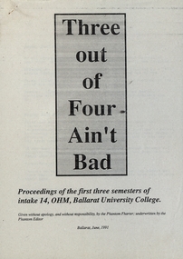
Document - Document - Year Book, VIOSH: Ballarat University College; Intake 14, Occupational Hazard Management
Victorian Institute of Occupational Safety and Health (VIOSH) Australia is the Asia-Pacific centre for teaching and research in occupational health and safety (OHS) and is known as one of Australia's leaders on the field. VIOSH has a global reputation for its innovative approach within the field of OHS management. VIOSH had its first intake of students in 1979. At that time the Institution was known as the Ballarat College of Advanced Education. In 1990 it became known as Ballarat University College, then in 1994 as University of Ballarat. It was 2014 that it became Federation University. VIOSH Australia students are safety managers, senior advisors and experienced OHS professionals. They come from all over Australia and industry. Students are taught active research and enquiry; rather than textbook learning and a one-size fits all approach. VIOSH accepts people into the Graduate Diploma of Occupational Hazard Management who have no undergraduate degree - on the basis of extensive work experience and knowledge. Articles written by students of their first three semesters at Ballarat University College. They were Intake 14 of the Graduate Diploma in Occupational Hazard Management. The collection was called "Three out of Four Ain't Bad". Many references made about individual students and lecturers. Lecturers mentioned were Steve Cowley, Dennis Else, Eric Wigglesworth and Derek Viner. Students were Peter Adams, Marcus Baker, Andrew Batterson, Jim Bonder, Sean Boyle, Jan Chipchase, Hok Ch'ng, Ray Clifford, Natalie Comrie, Doug Cunningham, Lee Davidson, Brett Deale, Kathleen Fysh, Geoff Hurst, Jenny Jackson, Mark Lewis, Anne Lord, Werner Lushington, Joy Monckton, Clint Morton, Susan Pilkington, Corey Quinn, Richard Ridout, Alan Ryan, Chris Sanders, David Skegg, Gary Thompson, Andrea Tidey, Doug Wait, Brent Walton, Susan Watt, Susan Whiteley, Rohanne Young, John Zivanovic. Thirty-eight A4 sheets, pale grey, printed.Names of students and lecturers. Page numbers written by hand, bottom right corner.viosh, victorian institute of occupational safety and health, ballarat university college, graduate diploma in occupational hazard management, steve cowley, dennis else, eric wigglesworth, derek viner, three out of four ain't bad, peter adams, marcus baker, andrew batterson, jim bonder, sean boyle, jan chipchase, hok ch'ng, ray clifford, natalie comrie, doug cunningham, lee davidson, brett deale, kathleen fysh, geoffrey hurst, jenny jackson, mark lewis, anne lord, werner lushington, joy monckton, clint morton, susan pilkington, corey quinn, richard ridout, alan ryan, chris sanders, david skegg, gary thompson, andrea tidey, doug wait, brent walton, susan watt, susan whiteley, rohanne young, jon zivanovic -
 Flagstaff Hill Maritime Museum and Village
Tool - Wood Moulding Plane, 1770-1809
The story of Christopher Gabriel born on April 2, 1746, in Falmouth England is a tale of a poor boy who made good. Shortly before he turned thirteen years of age in 1759 he was apprenticed to a local master carpenter, recorded as a Mr Barnicot the master trained his apprentice well as we can assume by Christopher's later successes. The apprenticeship ended in 1766 after seven years when Christopher reached twenty. Then in 1768, he relocated to London walking the two hundred miles from Falmouth carrying his possessions in a sack. He no sooner arrived in London when he met Alice Trowell who became his wife in March 1769. They set up house on Albermarie Street Clerkenwell and by the first of 1770, Gabriel had begun his business of plane making. It has been speculated that Gabriel took over the shop of John Cogdell aided with an investment from his in-laws of 131 pounds. He went on to prosper as a plane-maker and lumber merchant over the next forty years. His business did well and in 1774 Gabriel moved to a house in Golden Lane, London and 1779 moved again to a home in Ould Street London. By now Gabriel was making a name for himself and his business at this time was located at 32 Banner Street Golden Lane, the following year he purchased another home in Banner Street and 1793 purchased the house next door. At the time of his death in 1808, he owned twenty-seven houses and commercial building. Christopher Gabriel s descendants became quite prominent in England and his grandson, Sir Thomas Gabriel became the Sheriff of London and Middlesex in 1859 and the Lord Mayor of London 1866 and 1867. Gabriel was an extremely prolific plane-maker with a lot of examples made in the 18th century can still be found today. He made good quality tools and was an innovator of several new plane designs. A vintage tool made by a well-known plane-maker, this item was made commercially for firms and individuals that worked in wood and needed a tool that could give a decorative finish to timber. These planes came in various shapes and sizes to achieve a finish to timber surfaces and came in many sizes. A significant Christopher Gabriel plane from the mid to late 18th century that after 200 years can still be used today. Planes made by Gabriel are eagerly sought after by collectors. The tool gives us a snapshot of how furniture and other finishes were created on timber by the use of cutting edged hand tools. Tools that were themselves hand made shows the craftsmanship used during this time not only to make a tool such as the subject item but also the craftsmanship needed to produce a decorative or even finish that was needed for the finishing of timber items. Moulding multi patterned plane has a "5" long bladeStamped Maker C Gabriel (owner JB).flagstaff hill, warrnambool, shipwrecked-coast, flagstaff-hill, flagstaff-hill-maritime-museum, maritime-museum, shipwreck-coast, flagstaff-hill-maritime-village, side rabbet plane, gabriel m hobling -
 Eltham District Historical Society Inc
Negative - Photograph, Bootmaker's shop adjacent to Whitecloud Cottage, 701 Main Road, Eltham, 5 June 1990
One of only three remaining early 20th century shops in the former Little Eltham district. The bootmaker's shop was operated by John Henry (Harry) Clark from about 1930. Clark was originally a photographer along with his brothers William (Will) Charles Clark and Clement Kent Clark. They operated as Clark Bros Photographers based at 25 Thomas Street, Windsor (Prahran) from about 1895 to 1915 at which point the premises was demolished.. Brother Clement died in 1912. From about 1910 Harry was living and working as a photographer in Eltham and was recorded on the electoral rolls as a photographer from 1915 up to and including at least 1928. He boarded with Thekla Jarrold and the Jarrold family in the Jarrold family cottage (Whitecloud). By 1931 he changed his profession to Bootmaker and Thekla Jarrold built him this litrtle shop circa 1930 on the corner of her property next to the family home. He was well regarded by all as a fine leather worker and operated as a Bootmaker from his little shop at least until 1954. He died at St Vincent'e Hospital in Dec 1956. Very little public record exists of Harry in the papers either as a photographer or bootmaker, one incident was reported in 1935 when he witnessed a girl on a bike come crashing down Dalton Street and across Main Road into the pond next to his shop. ELTHAM GIRL THROWN FROM CYCLE (1935, April 26). Advertiser (Hurstbridge, Vic. : 1922 - 1939), p. 1. Retrieved September 21, 2021, from http://nla.gov.au/nla.news-article56838786 Another reference is recorded in 1932 when Council proposed to drain the adjacent pond due to complaints about mosquitoes. Both Harry and Thekla objected to the proposal. The paper reported that Thekla had lived there for 39 years at the time and Harry for 22 withoiut any cause for concern about the pond.Roll of 35mm colour negative film, 7 strips And associated colour print 10 x 15 cmFuji 200 Aeltham, buildings, houses, main road, bootmakers cottage, bootmakers, dalton street, white cloud cottage, jarrold, whitecloud cottage, jarrold cottage, jarrold property -
 Eltham District Historical Society Inc
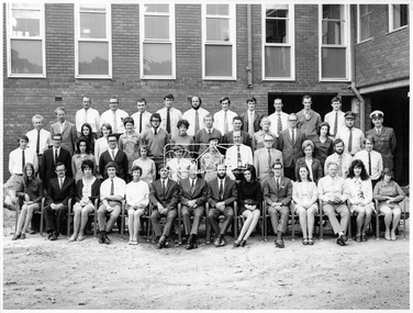
Photograph, Hugh Fisher, Eltham Shire Council Staff, Shire Centenary Anniversary, 6 April 1971
Formal photograph of group of men and women employed by the Shire of Eltham, to commemorate the Shire Centenary April 1971. Photograph taken at the rear of the Council Offices, Main Road, Eltham Includes Eltham Shire Council Staff List and Phone Numbers, 1971 1971 Eltham Shire Council Staff Photo (SEPP_4050 and SEPP_4051) L-R Back Row: N. Stuart (Engineering), N. Campbell (Engineering), W. Oakley (Engineering), R. McIldowie (Engineering), D. Welch (Engineering), G. Pullen (Accounts), J. Bleazby (Rates), P. Sturtevent (Engineering), B. Hill (Engineering), F. Harrington (Engineering) Third Row: C. Harris (Building), M. Van Ewijk (Accounts), Miss C. Casella (Administration), Miss D. Curran (Rates), M. Howard (Administration), Dennis McKay (Engineering), Mrs L. Crockett (Accounts), A. Liepa (Engineering), G. Newton (Building), Mrs N. Davis (Administration), I. Leach (Health), Mrs F. Conyers (Rates), B. Wright (ranger), I. Caig (Traffic By-Laws Officer) Second Row: J. Constable (Accounts), J. Parsons (Health), Mrs J. Baker (Health), P. Hoare (Engineering), Miss R. Spearman (Rates), D. Golder (Engineering), Mrs R. Cox (Administration), H. Masefield (Fire Proper Officer), A. Birch (Engineering), Sister L. Cameron (Health), Russell Yeoman (Engineering), T. Phyland (Engineering) Front Row (seated): Miss D. Vreulink (Administration), D. Lovatt (Health), Mrs H. Dixson (Accounts), M. Fowler (Rates), Mrs L. Harris (Administration), C. Gaudion (Health), M. Watson (Shire Secretary), A. Roberts (Administration), Miss J. Featherby (Engineering), M. Verhoeven (Engineering), Mrs M. Lethlean (Engineering), I. McDonald (Rate Collector), Mrs W. Klooster (Engineering), Mrs C. Bell (Engineering) Absent: John McDonald (Shire Engineer) This photo forms part of a collection of photographs gathered by the Shire of Eltham for their centenary project book,"Pioneers and Painters: 100 years of the Shire of Eltham" by Alan Marshall (1971). The collection of over 500 images is held in partnership between Eltham District Historical Society and Yarra Plenty Regional Library (Eltham Library) and is now formally known as the 'The Shire of Eltham Pioneers Photograph Collection.' It is significant in being the first community sourced collection representing the places and people of the Shire's first one hundred years.Digital image Print Foolscap page typedInscribed A2207A (SEPP_4050) 2nd version inscribed A2207B (SEPP_4051)a. birch, a. liepa, a. roberts, b. hill, b. wright, c. gaudion, c. harris, council, council staff, council-staff, d. golder, d. lovatt, d. welch, dennis mckay, eltham-shire-council, f. harrington, g. newton, g. pullen, h. masefield, i. caig, i. leach, i. mcdonald, j. bleazby, j. constable, j. parsons, john mcdonald, m. fowler, m. howard, m. van ewijk, m. verhoeven, m. watson, miss c. casella, miss d. curran, miss d. vreulink, miss j. featherby, miss r. spearman, mrs c. bell, mrs f. conyers, mrs h. dixson, mrs j. baker, mrs l. crockett, mrs l. harris, mrs m. lethlean, mrs n. davis, mrs r. cox, mrs w. klooster, n. campbell, n. stuart, p. hoare, p. sturtevent, r. mcildowie, russell yeoman, shire of eltham centenary, shire of eltham pioneers photograph collection, sister l. cameron, t. phyland, w. oakley -
 Eltham District Historical Society Inc
Photograph, Hugh Fisher, Eltham Shire Council Staff, Shire Centenary Anniversary, 6 April 1971
Formal photograph of group of men and women employed by the Shire of Eltham, to commemorate the Shire Centenary 6 April 1971. Photograph taken at the rear of the Council Offices, Main Road, Eltham 1971 Eltham Shire Council Staff Photo (SEPP_4050 and SEPP_40511) L-R Back Row: N. Stuart (Engineering), N. Campbell (Engineering), W. Oakley (Engineering), R. McIldowie (Engineering), D. Welch (Engineering), G. Pullen (Accounts), J. Bleazby (Rates), P. Sturtevent (Engineering), B. Hill (Engineering), F. Harrington (Engineering) Third Row: C. Harris (Building), M. Van Ewijk (Accounts), Miss C. Casella (Administration), Miss D. Curran (Rates), M. Howard (Administration), Dennis McKay (Engineering), Mrs L. Crockett (Accounts), A. Liepa (Engineering), G. Newton (Building), Mrs N. Davis (Administration), I. Leach (Health), Mrs F. Conyers (Rates), B. Wright (ranger), I. Caig (Traffic By-Laws Officer) Second Row: J. Constable (Accounts), J. Parsons (Health), Mrs J. Baker (Health), P. Hoare (Engineering), Miss R. Spearman (Rates), D. Golder (Engineering), Mrs R. Cox (Administration), H. Masefield (Fire Proper Officer), A. Birch (Engineering), Sister L. Cameron (Health), Russell Yeoman (Engineering), T. Phyland (Engineering) Front Row (seated): Miss D. Vreulink (Administration), D. Lovatt (Health), Mrs H. Dixson (Accounts), M. Fowler (Rates), Mrs L. Harris (Administration), C. Gaudion (Health), M. Watson (Shire Secretary), A. Roberts (Administration), Miss J. Featherby (Engineering), M. Verhoeven (Engineering), Mrs M. Lethlean (Engineering), I. McDonald (Rate Collector), Mrs W. Klooster (Engineering), Mrs C. Bell (Engineering) Absent: John McDonald (Shire Engineer) This photo forms part of a collection of photographs gathered by the Shire of Eltham for their centenary project book, "Pioneers and Painters: 100 years of the Shire of Eltham" by Alan Marshall (1971). The collection of over 500 images is held in partnership between Eltham District Historical Society and Yarra Plenty Regional Library (Eltham Library) and is now formally known as 'The Shire of Eltham Pioneers Photograph Collection.' It is significant in being the first community sourced collection representing the places and people of the Shire's first one hundred years.Digital image Print 20 x 25 cmInscribed A2207A (SEPP_4050) 2nd version inscribed A2207B (SEPP_4051)a. birch, a. liepa, a. roberts, b. hill, b. wright, c. gaudion, c. harris, council, council staff, council-staff, d. golder, d. lovatt, d. welch, dennis mckay, eltham-shire-council, f. harrington, g. newton, g. pullen, h. masefield, i. caig, i. leach, i. mcdonald, j. bleazby, j. constable, j. parsons, john mcdonald, m. fowler, m. howard, m. van ewijk, m. verhoeven, m. watson, miss c. casella, miss d. curran, miss d. vreulink, miss j. featherby, miss r. spearman, mrs c. bell, mrs f. conyers, mrs h. dixson, mrs j. baker, mrs l. crockett, mrs l. harris, mrs m. lethlean, mrs n. davis, mrs r. cox, mrs w. klooster, n. campbell, n. stuart, p. hoare, p. sturtevent, r. mcildowie, russell yeoman, shire of eltham centenary, shire of eltham pioneers photograph collection, sister l. cameron, t. phyland, w. oakley -
 Orbost & District Historical Society
black and white photograph, H.A. Dart, C1890
"The 19th of March 1886 proved an important day in the lives of many early settlers in the Orbost area, because on this day the Orbost State School opened. The fact that the school had first operated temporarily in a leased building, and on a half-time basis with SS2745 Jarrahmond, did not dampen the enthusiasm of the local inhabitants as they saw their offspring commence their education under the guidance of HT Campbell Mackay. However he remained in charge only until 12th of May 1886. The second HT, John Rowe, served until 1908. On 30th of June 1887, a portable room was provided; it being brought to the area by schooner. The school now had accommodation for 30 pupils; the teacher's welfare was considered because quarters of two rooms were attached. As the population increased so did the needs of the school. This was reflected in the provision of a larger classroom in 1898. During 1910-11 the first approaches were made to the Department for the establishment of a HES in Orbost and this became a reality in 1912. Orbost HES supplied post-primary education in the district until a high school was built in 1948. When fire destroyed the school in 1941 local halls were used as classrooms until a new school was built. Work was quite rapid and a new brick structure was opened by the Hon. A. E. Lind, MLA, on 13th of February 1942. This new building was a fine type of school of which both the pupils and the HT Leslie Collins were indeed proud. But Orbost continued to develop and the new school was soon overtaxed. This resulted in the erection of two Bristol classrooms in 1947. By 1950, when the school population had reached 500 pupils the opening of the new school at Orbost North was welcomed by all concerned. In 1963 the Department purchased land diagonally opposite the school and developed it as a playing area. In 1965 two LTCs were opened in November, and in October 1968 the Brodribb School building was moved to SS2744 Orbost for use as a general purpose room." This item is associated with the history of education in Orbost.A black / white photograph of a group of students, some kneeling, some sitting, in a school yard. It is framed in grey buff cardboard with a photographer's stamp at the bottom.H. A. Dart Melbourne in gold print at the bottom.photograph-orbost-state-school -
 Orbost & District Historical Society
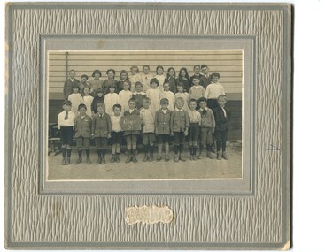
black and white photograph, C1900
The 19th of March 1886 proved an important day in the lives of many early settlers in the Orbost area, because on this day the Orbost State School opened. The fact that the school had first operated temporarily in a leased building, and on a half-time basis with SS2745 Jarrahmond, did not dampen the enthusiasm of the local inhabitants as they saw their offspring commence their education under the guidance of HT Campbell Mackay. However he remained in charge only until 12th of May 1886. The second HT, John Rowe, served until 1908. On 30th of June 1887, a portable room was provided; it being brought to the area by schooner. The school now had accommodation for 30 pupils; the teacher's welfare was considered because quarters of two rooms were attached. As the population increased so did the needs of the school. This was reflected in the provision of a larger classroom in 1898. During 1910-11 the first approaches were made to the Department for the establishment of a HES in Orbost and this became a reality in 1912. Orbost HES supplied post-primary education in the district until a high school was built in 1948. When fire destroyed the school in 1941 local halls were used as classrooms until a new school was built. Work was quite rapid and a new brick structure was opened by the Hon. A. E. Lind, MLA, on 13th of February 1942. This new building was a fine type of school of which both the pupils and the HT Leslie Collins were indeed proud. But Orbost continued to develop and the new school was soon overtaxed. This resulted in the erection of two Bristol classrooms in 1947. By 1950, when the school population had reached 500 pupils the opening of the new school at Orbost North was welcomed by all concerned. In 1963 the Department purchased land diagonally opposite the school and developed it as a playing area. In 1965 two LTCs were opened in November, and in October 1968 the Brodribb School building was moved to SS2744 Orbost for use as a general purpose room. ( info. Schools East Gippsland) This item is associated with the history of education in Orbost.A black / white photograph framed by a grey buff card. It shows grade three students standing in front of a wooden school building.education-orbost orbost-state-school -
 Orbost & District Historical Society
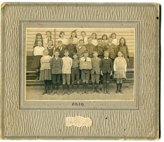
black and white photograph, Wilson, Les G, 1919
The 19th of March 1886 proved an important day in the lives of many early settlers in the Orbost area, because on this day the Orbost State School opened. The fact that the school had first operated temporarily in a leased building, and on a half-time basis with SS2745 Jarrahmond, did not dampen the enthusiasm of the local inhabitants as they saw their offspring commence their education under the guidance of HT Campbell Mackay. However he remained in charge only until 12th of May 1886. The second HT, John Rowe, served until 1908. On 30th of June 1887, a portable room was provided; it being brought to the area by schooner. The school now had accommodation for 30 pupils; the teacher's welfare was considered because quarters of two rooms were attached. As the population increased so did the needs of the school. This was reflected in the provision of a larger classroom in 1898. During 1910-11 the first approaches were made to the Department for the establishment of a HES in Orbost and this became a reality in 1912. Orbost HES supplied post-primary education in the district until a high school was built in 1948. When fire destroyed the school in 1941 local halls were used as classrooms until a new school was built. Work was quite rapid and a new brick structure was opened by the Hon. A. E. Lind, MLA, on 13th of February 1942. This new building was a fine type of school of which both the pupils and the HT Leslie Collins were indeed proud. But Orbost continued to develop and the new school was soon overtaxed. This resulted in the erection of two Bristol classrooms in 1947. By 1950, when the school population had reached 500 pupils the opening of the new school at Orbost North was welcomed by all concerned. In 1963 the Department purchased land diagonally opposite the school and developed it as a playing area. In 1965 two LTCs were opened in November, and in October 1968 the Brodribb School building was moved to SS2744 Orbost for use as a general purpose room. ( Info. from Schools East Gippsland) This item is associated with the history of education in Orbost.A black / white photograph on a grey buff cardboard frame. It is of a group of students standing outside the Orbost State School building. One child holds a sign reading "Form F". There is a photographer's label at the bottom.on back - "Alen Roach" on front - "1919" education-orbost orbost-state-school -
 Orbost & District Historical Society
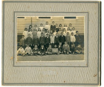
black and white photograph, Wilson, Les G, 1919
The 19th of March 1886 proved an important day in the lives of many early settlers in the Orbost area, because on this day the Orbost State School opened. The fact that the school had first operated temporarily in a leased building, and on a half-time basis with SS2745 Jarrahmond, did not dampen the enthusiasm of the local inhabitants as they saw their offspring commence their education under the guidance of HT Campbell Mackay. However he remained in charge only until 12th of May 1886. The second HT, John Rowe, served until 1908. On 30th of June 1887, a portable room was provided; it being brought to the area by schooner. The school now had accommodation for 30 pupils; the teacher's welfare was considered because quarters of two rooms were attached. As the population increased so did the needs of the school. This was reflected in the provision of a larger classroom in 1898. During 1910-11 the first approaches were made to the Department for the establishment of a HES in Orbost and this became a reality in 1912. Orbost HES supplied post-primary education in the district until a high school was built in 1948. When fire destroyed the school in 1941 local halls were used as classrooms until a new school was built. Work was quite rapid and a new brick structure was opened by the Hon. A. E. Lind, MLA, on 13th of February 1942. This new building was a fine type of school of which both the pupils and the HT Leslie Collins were indeed proud. But Orbost continued to develop and the new school was soon overtaxed. This resulted in the erection of two Bristol classrooms in 1947. By 1950, when the school population had reached 500 pupils the opening of the new school at Orbost North was welcomed by all concerned. In 1963 the Department purchased land diagonally opposite the school and developed it as a playing area. In 1965 two LTCs were opened in November, and in October 1968 the Brodribb School building was moved to SS2744 Orbost for use as a general purpose room. (info. Schools east Gippsland) This item is associated with the history of education in Orbost.A black / white photograph on a grey buff cardboard frame. It is of students outside the Orbost State School. A child in the centre bottom row is holding a sign reading " Grades 5 & 6".on back - "Mary Gilbert"education-orbost orbost-state-school -
 Orbost & District Historical Society
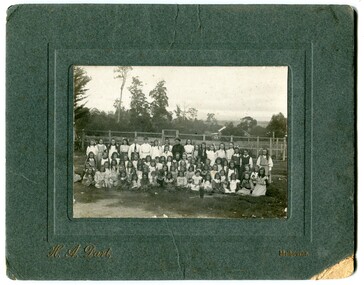
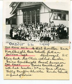
black and white photograph, 1909
This item is part of the Mary Gilbert Collection. Top Row on Left - Ethel Scouller; Una Roadknight; Rene Rodwell; Nathan Spielvogel (Head Teacher) Bottom Left - Elsie Cook; Miss Olivier with hat (teacher); Erica Roadknight, Penuel Cameron Far Right - Dorrie Roadknight;with hat (teacher); 3rd from left Vera Nixon; Sally Draffin behind her; Linda Gluth in front of Dorrie Tthe Orbost State School opened on19th of March 1886. The school had first operated temporarily in a leased building, and on a half-time basis with SS2745 Jarrahmond, The head teacher was Campbell Mackay who remained in charge only until 12th of May 1886. The second head teacher, John Rowe, served until 1908. On 30th of June 1887, a portable room was provided; it being brought to the area by schooner. The school now had accommodation for 30 pupils; the teacher's welfare was considered because quarters of two rooms were attached. As the population increased so did the needs of the school. This was reflected in the provision of a larger classroom in 1898. During 1910-11 the first approaches were made to the Department for the establishment of a Higher Elementary School in Orbost and this became a reality in 1912. Orbost. The Higher Elementary School supplied post-primary education in the district until a high school was built in 1948. When fire destroyed the school in 1941 local halls were used as classrooms until a new school was built, opened by the Hon. A. E. Lind, MLA, on 13th of February 1942. But Orbost continued to develop and the new school was soon overtaxed. This resulted in the erection of two Bristol classrooms in 1947. By 1950, when the school population had reached 500 pupils the opening of the new school at Orbost North was welcomed by all concerned. In 1963 the Department purchased land diagonally opposite the school and developed it as a playing area. This item is associated with education in Orbost.A black / white photograph with a list of names attached to the bottom. It shows a group of students and teachers in front of a wooden school building.on label - Orbost S.S. 1909 with a list of identifying nameseducation-orbost orbost-state-school -
 Federation University Historical Collection
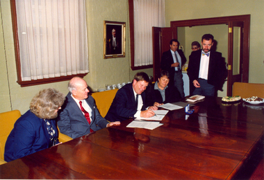
Photographs - Colour, Hillman Award Agreement and Presentation, 1991, 1991
Lindsay F.J. Hillman was born in Ballarat, and attended the Ballarat Junior Technical School. He became a cadet in Electrical Engineering Laboratory at the Ballarat School of Mines where he gained eventually gained a student Teachership for diploma studies at the School. Hillman was particularly active and excelled in a wide range of sporting interests and in student activities. In 1928 and 1928 he was awarded the Ballarat School of Mines Honour blazer by the Old Boys' association for all round athletic ability, leadership and scholarship. After spending two years with the Melbourne City Council Electric Supply Department gaining industrial experience Hillman was awarded his Diploma of electrical engineering in 1931, returning to the School in 1932 to teach apprentices and senior students. Hillman was appointed lecturer in Engineering Design and Graphics in 1937, lecturer in Engineering Design and Civil Engineering in 1944, Lecturer-in-Charge of Mechanical and Civil Engineering in 1948 and Head of the Electrical Engineering Department in 1949, a position he held until his retirement in 1973. In 1975 Lindsay Hillman was appointed to the Council of the Ballarat School of Mines and played an active role in school affairs.As Vice-President of Council from 1981 until his death in 1991 Hillman took a leading part in the implementation of many of the major building projects on the Lydiard Street Campus. The L.F.J. Hillman Award was established by the Ballarat School of Mines Council in conjunction with and through the generosity of the Hillman family in honour of the late Lindsay Frederick John Hillman. The bronze medal was presented annually to an enrolled student in an accredited course in the field of electrical/electronics studies at the Ballarat School of Mines. specific Criteria for the Award consisted of a balance of academic performance, leadership qualities, commitment to further study and involvement in sporting and/or community groups. The first Hillman Award was presented in 1991. The recipients are: 1991: Paul Donald 1992 - Brett A. Hovey 1994 - Brent L. Ferguson 1995 - Kirsty McKenzie 1996 - Peter J. WhiteEighteen colour photographs of the signing of the Hillman award agreement and the first presentation of the award in 1991 to Paul Donald . .2) Gregor Hillman, Judith Tinney and Caroline Bethune .4) Judith Tinney or Caroline Bethune and Bill Gribble sign the agreement .8) Gregor Hillman, Judith Tinney and Caroline Bethune sign the agreement, along with President of the Ballarat School of Mines, Bill Gribble. .10) Paul Donald with his L.F.J. Hillman Award, 1991 .11) Ballarat School of Mines Principal, Peter Shiells, speaks at the lectern watched on by members of the Hillman family.ballarat school of mines, hillman, lindsay hillman, medal, numismatics, electrical engineering, electronics, gregor hillman. judith tinney, caroline bethune, tinney, bethune, hovey, ferguson, mckenzie, white, paul donald, donald -
 Flagstaff Hill Maritime Museum and Village
Document - Navigation Chart, Admiralty Office, Lady Bay and Warrnambool Harbour, 1893
This navigation cart of Lady Bay and Warrnambool Harbour was originally surveyed in 1870 but this version includes the update for magnetic variation in 1893. Since the printing of the chart several annotations have been added. These include an additional stamp dated 15-8-1910, a handwritten comment across the top of the page dated August 1910, and another handwritten comment regarding the ‘Proposed Extension of Dock’ dated 19-2-1925, plus connected drawings, notes and figures. The 1925 proposal on this chart may have been a reaction to the Royal Commission of 1923, when the damaged stonework on the seaward side of the Warrnambool Breakwater, caused by the action of the sea, was the subject of enquiry. A conference between the Public Works, Water Commission and the Harbour Trust concluded that it would less costly to make repairs to prevent further damage rather than replaced the damage portion of the wall. A contract was raised in late 1924 to deposit rubble on the damaged side of the breakwater to minimise the Southern Ocean’s destructive action and work had started by August 1925. The Breakwater construction had begun in 1874 and was completed in 1890. The Victorian Government had commissioned Sir John Coode, a British harbour engineer, to present a plan to complete the Warrnambool Breakwater but his original plan was too expensive. He prepared a revised plan for a shorter structure. The construction proved to be too short to protect adequately from the weather and didn't allow enough depth for larger vessels to come into port. The decreasing trade was further affected by siltation in the bay due to the breakwater, and the completion of the railway line. The situation of the harbour became a real problem by 1910 and required continuous dredging. In 1914 the Breakwater was extended but proved to be a failure because the work began to subside and by 1920 about two thirds of the harbour was silted up. Alterations made in the 1920's increased the silting problem and by the 1940's the harbour was no longer used. More alterations were made in the 1950's and 1960's. This chart is significant for its strong connection to the maritime history of Warrnambool Harbour and Lady Bay and the Warrnambool Breakwater. The Warrnambool Breakwater is registered as a place of significance on the Victorian Heritage Database (VHR H2024). The Warrnambool Breakwater is one of the most important late 19th century maritime engineering projects in Victoria and significant in the development of Victorian coastal shipping. It is also significant for its connection with British harbour engineer, Sir John Coode. The chart is a historical record of structures existing in 1893; the Warrnambool Jetties, Warrnambool Breakwater in Lady Bay, the leading lights (lighthouses), streets, roads, bridges and many buildings. It also shows the lay of the land and seabed. Navigation Chart: Lady Bay and Warrnambool Harbour, Australia - South Coast - Victoria. Surveyed by Nav. Lieut. H.J. Stanley, R.N., 1870. Updated for Magnetic Variation, 1893. The rectangular chart is printed on heavy cream paper. Stamps are shaped rectangular, oval and round. Around the Breakwater and Jetty area are handwritten notes, dotted and joined lines, numbers and signatures, and shading of red and green. The chart shows the surrounds of Warrnambool Harbour, Lady Bay, the Breakwater and Jetty, roads, bridges and the streets in Warrnambool. It has sounding details, and angles of line from the leading lights.Stamp, rectangular, including "AUG 1910" Stamp, double oval " - - - -CHART" Stamp, hand drawn, red circle, with "B" inside Hand written note "22-8-1910 - - - - - of surveying C. Ca - - - request of 15-8-10 [initials] " Notes and lines in red pen, including a grid of sounding numbers: "1300" "1050" "1200" "Possible Extension of Dock" "19-2-25" "Dock Dredged to 20 Ft" Notes and lines in blue pen "Extension of Dock to accommodate vessels drawing 20 Feet" and "Light not visible south of this line" Red dots (4) with yellow highlight at both leading lights, breakwater and jettyflagstaff hill, warrnambool, flagstaff hill maritime museum & village, maritime museum, maritime village, shipwreck coast, map, chart, navigation chart, plan, lady bay, warrnambool harbour, port of warrnambool, breakwater, jetty, pier, dock extension, proposed extension, vhr h2024, 1870, 1893, 1910, 1925, warrnambool town late 1800s, warrnambool streets late 1800s royal commission, 1923, public works, water commission, harbour trust, victorian harbours, sir jon coode -
 Flagstaff Hill Maritime Museum and Village
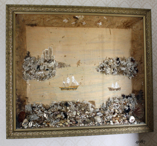
Artwork, other - Wall decoration, late 19th century
This unusual wall decoration was created by Anna Wilson (nee Henry), daughter of pioneer John Stephenson Henry, who arrived in Australia from Ireland with his children in 1851. Family documents confirm that Anna most probably made the diorama for her sister-in-law, who married a member of the Giles family. The diorama was later given to Vera Giles who was a family friend and possibly related to Anna’s sister-in-law by marriage. The diorama is now part of the Giles Collection. Anna married William Wilson in 1860, who had arrived in Australia from County Tarrane in about 1850, aged 19. In 1869 they moved to their new property called ‘Glenlyall’ in Cooramook, north of Grassmere, Victoria, where he lived for 49 years until his death in 1918. He left behind a family of four sons and a daughter. The Giles Family There are many 19th century items of furniture, linen and crockery donated to Flagstaff Hill Maritime Village by Vera and Aurelin Giles. The items are associated with the Giles Family and are known as the “Giles Collection”. These items mostly came from the simple home of Vera’s parents-in-law, Henry Giles and his wife Mary Jane (nee Freckleton), whose photos are in the parlour. They married in 1880. Henry Giles was born at Tower Hill in 1858. He was a labourer on the construction of the Breakwater before leaving in 1895 to build bridges in N.S.W. for about seven years. Mary Jane was born in 1860 at Cooramook. She attended Mailor’s Flat State School where she was also a student teacher before, as family legend has it, she became a governess at “Injemiara” where her grandfather, Francis Freckleton, once owned land. Henry and Mary’s family of six, some of whom were born at Mailor’s Flat and later children at Wangoom, lived with their parents at Wangoom and Purnim west, where Henry died in 1933 and Mary Jane in 1940. The family of the creator Anna Wilson nee Henry and her husband William Wilson are of significance to the early history of Victoria and the South West of Victoria in particular, being pioneer families who farmed the land, built the towns and cities and contributed to their communities. The Giles family collection has social significance at a local level, because it illustrates the level of material support the Warrnambool community gave to Flagstaff Hill when the Museum was established. Wall decoration, diorama with decorative gild frame and glass front. The 3-dimensional seascape includes sailing boats, land and sea, all made from materials such as shells, coral and seaweed. The work was made by Anna Wilson. It is part of the Giles Collection.Noneflagstaff hill, warrnambool, shipwrecked-coast, flagstaff-hill, flagstaff-hill-maritime-museum, maritime-museum, shipwreck-coast, flagstaff-hill-maritime-village, giles collection, henry giles, tower hill, cooramook, warrnambool breakwater, mailor’s flat, wangoom, 19th century household goods, 19th century decor, 19th century handcraft, handcraft, wall hanging, diorama of a seascape -
 Flagstaff Hill Maritime Museum and Village
Instrument - Foghorn, Late 19th century
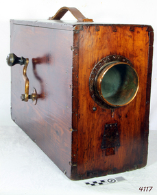
A foghorn is a device that uses sound to warn of navigational hazards like rocky coastlines, or boats of the presence of other vessels, in foggy conditions. The term is most often used with marine transport. When visual navigation aids such as lighthouses are obscured, foghorns provide an audible warning of rocky outcrops, shoals, headlands, or other dangers to shipping. An early form of fog signal was to use a bell, gong, explosive signal or firing a cannon to alert shipping. From the early 20th century an improved device called the diaphone was used in place of these other devices, The diaphone horn was based directly on the organ stop of the same name invented by Robert Hope-Jones, creator of the Wurlitzer organ. Hope-Jones' design was based on a piston that was closed only at its bottom end and had slots, perpendicular to its axis, cut through its sides, the slotted piston moved within a similarly slotted cylinder. Outside of the cylinder was a reservoir of high-pressure air. Initially, this air would be admitted behind the piston, pushing it forward. When the slots of the piston aligned with those of the cylinder, air passed into the piston, making a sound and pushing the piston back to its starting position, whence the cycle would be repeated. This method of producing a low audible sound was further developed as a fog signal by John Northey of Toronto and these diaphones were powered by compressed air produced by an electric motor or other mechanical means that admitted extremely powerful low-frequency notes. The example in the Flagstaff collection is an early cased and portable diaphone used on pleasure or sailing craft. By manually turning the crank handle air is produced and fed into valves that direct air across vibrating metal reeds to produce the required sound. in foggy weather, fog horns are used to pinpoint a vessels position and to indicate how the vessel is sailing in foggy conditions. One blast, when sailing on starboard tack and two blasts, when sailing on a port tack and three dots, when with wind is behind the vessel. Since the automation of lighthouses became common in the 1960s and 1970s, most older foghorn marine installations have been removed to avoid the need to run the complex machinery associated with them, and have been replaced with an electrically powered diaphragm or compressed air horns. The example in the collection is significant as it was used in the early 19th century for sailing vessels was important but these portable crank fog horns have also been superseded by modern electric varieties. Therefore the item has a historical connection with sailing and maritime pursuits from our past.English Rotary Norwegian Pattern nautical foghorn within a boxed pine varnished case with exposed corner dovetailing, original leather carrying strap, brass side crank, and original copper trumped horn. Card accessory with Directions for Use in both English and French.Noneflagstaff hill, warrnambool, shipwrecked coast, flagstaff hill maritime museum, maritime museum, shipwreck coast, flagstaff hill maritime village, great ocean road, foghorn, maritime technology, maritime communication, marine warning signal, portable foghorn, bellows foghorn, crank handle, robert hope-jones, john northey -
 Flagstaff Hill Maritime Museum and Village
Tool - Moulding Plane, 1770-1809
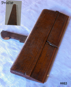
The story of Christopher Gabriel born on April 2, 1746, in Falmouth England is a tale of a poor boy who made good. Shortly before he turned thirteen years of age in 1759 he was apprenticed to a local master carpenter, recorded as a Mr Barnicot the master trained his apprentice well as we can assume by Christopher's later successes. The apprenticeship ended in 1766 after seven years when Christopher reached twenty. Then in 1768, he relocated to London walking the two hundred miles from Falmouth carrying his possessions in a sack. He no sooner arrived in London when he met Alice Trowell who became his wife in March 1769. They set up house on Albermarie Street Clerkenwell and by the first of 1770, Gabriel had begun his business of plane making. It has been speculated that Gabriel took over the shop of John Cogdell aided with an investment from his in-laws of 131 pounds. He went on to prosper as a plane-maker and lumber merchant over the next forty years. His business did well and in 1774 Gabriel moved to a house in Golden Lane, London and 1779 moved again to a home in Ould Street London. By now Gabriel was making a name for himself and his business at this time was located at 32 Banner Street Golden Lane, the following year he purchased another home in Banner Street and 1793 purchased the house next door. At the time of his death in 1808, he owned twenty-seven houses and commercial building. Christopher Gabriel s descendants became quite prominent in England and his grandson, Sir Thomas Gabriel became the Sheriff of London and Middlesex in 1859 and the Lord Mayor of London 1866 and 1867. Gabriel was an extremely prolific plane-maker with a lot of examples made in the 18th century can still be found today. He made good quality tools and was an innovator of several new plane designs. A vintage tool made by a well-known plane-maker, this item was made commercially for firms and individuals that worked in wood and needed a tool that could give a decorative finish to timber. These planes came in various shapes and sizes to achieve a finish to timber surfaces and came in many sizes. A significant Christopher Gabriel plane from the mid to late 18th century that after 200 years can still be used today. Planes made by Gabriel are eagerly sought after by collectors. The tool gives us a snapshot of how furniture and other finishes were created on timber by the use of cutting edged hand tools. Tools that were themselves hand made shows the craftsmanship used during this time not only to make a tool such as the subject item but also the craftsmanship needed to produce a decorative or even finish that was needed for the finishing of timber items. Side Rabbet Plane Stamped Maker Gabriel (owner M Hobling).flagstaff hill, warrnambool, shipwrecked-coast, flagstaff-hill, flagstaff-hill-maritime-museum, maritime-museum, shipwreck-coast, flagstaff-hill-maritime-village, side rabbet plane, gabriel m hobling -
 City of Moorabbin Historical Society (Operating the Box Cottage Museum)
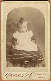
Photograph, B&W Jessie Melinda Box 1888 - 1975, c1889
Francis Box was born in Withyham, Sussex and came to Australia with his parents George and Mary Box and siblings in 1856. He was assigned to work in Beaufort and had various jobs including ‘gold miner’ at Heathcoat where he married Eliza Jane Thompson. Francis decided to return to market gardening after the death of his 1st child Francis George Box in 1875 aged 13months. The child was buried in Brighton Cemetery and Francis then rent/leased the land on the corner of Tucker Road and Elizabeth Street East Brighton ( now Bentleigh) owned by his brother Henry who with another brother John helped Francis clear the land, and establish a market garden. They had 4 children and began to prosper until in 1882 their 2year old child Lena Caroline Box was killed in a fire that destroyed their house. Francis was burned trying to rescue the child. The local community raised money to assist the family. The land boom brought prosperity again and Francis bought more land around Tucker Road which was bequeathed to his children. Francis and Eliza Jane had four more children but one died in infancy and another aged 2 years. Only 5 of their 9 children survived. Francis and Eliza Jane, who died in 1922, are also buried in Brighton Cemetery Jessie Melinda Box 1888- 1975 was born in East Brighton ( Bentleigh) the 8th child of Francis and Eliza Jane Box. She was a teacher in Eskdale, Victoria and married William Robinson d 1983, a farmer at Mitta in 1921. The family later moved to Tucker Road, Bentleigh where they ran a market garden until in 1950 they established "The Hilandale Poll Hereford Stud" at Notting Hill and Rowville. They moved to Mornington c 1960 where they continued their stud farming and enjoyed success at Melbourne, Sydney and local Shows. They had 2 children Jack Francis Robinson b1921, William James Robinson b1925. Box Cottage Museum, a reconstruction of an early settler hut, is named after the Box family who resided there 1865 -1913 . William Box who with his wife Elizabeth Avis Box and 13 children lived and farmed on the block of land in Jasper Road, East Brighton ( now McKinnon / Ormond) that was part of the Henry Dendy Special Survey 1841 . Francis Box, a brother of William Box, was born in Withyham, Sussex and came to Australia with his parents George and Mary Box and siblings in 1856. Francis established market gardens in Tucker Road Bentleigh. Jessie melinda Box was the 8th child of Francis Box Inscribed in Album “ The early photos in this album were found by Mr (Laurie) Lewis when he was demolishing the Old Box Cottage. He gave them to Mrs Avis Box Eldridge who in turn gave them to me. They were not identified. I believe they rightly belong in the Cottage. I have attempted to identify them and present them in a way they can be preserved as a historical record of the era.” A B Leigh A black and white photograph of Jessie Melinda Box a daughter of Francis Box and Elizabeth Jane Thompson Box c 1889YEOMAN & Co 47 Chapel Street, / Prahran* box george, box mary, box william, box elizabeth honor, box alonzo, box mary louisa, dendy henry, were j b, dendy's special survey 1841, brighton, moorabbin, bentleigh, mckinnon, ormond, market gardeners, dairy farms, early settlers, pioneers, tucker road, box francis , thompson eliza jane, box william henry george, box charles francis, , box mabel alma. box jessie melinda, robinson william, robinson jack francis, robinson william james, poll hereford stud farming, rowville, mornington, notting hill victoria, royal melbourne agricultural show, royal sydney agricultural show. cattle breeding, -
 Victorian Interpretive Projects Inc.
Photograph - Colour, Smeaton Primary School
In 1860 Smeaton residents appealed for funds to establish a school. Patrick Curtain, and his co-workers raised more than £150 plus a land grant (Allot A, Sect 2, Township of Smeaton). Head Teacher John Forbes, with assistant Zillah North, opened a timber school building which measured 36ftx18ft (11.0x5.5m) on 1 September 1861 with 44 children. Rising enrolment to 65 in 1868 made building alterations necessary. During 1870-1 a residence of four rooms was supplied and in October 1882 a 20ftx18ft (6.1x5.5m) classroom. In 1907 a new brick building accommodated 122 children. Among notable ex-pupils are Major-General Bridgeford, Frank Wright ( Musical Director of the London County Council), Alex Wright, (AKA singer Andre Navarre), and Les Brooks. (Visions and Realisations) In 2013 it was announced that Smeaton Primary School would close. The Hepburn advocate reported: "A Department of Education spokesman has confirmed the Smeaton Primary School council recently voted unanimously to recommend the school close at the end of the year. The school currently has 12 students with enrollments dwindling during the past few years and no prep students to its boost numbers or its future. The school’s imminent closure comes as the Smeaton community gears up for the town’s 175th anniversary which will be celebrated later this year. School council member Kristi Pedretti said it had not been a decision made lightly. “There are 12 students – only one in grade 6, about eight in grade 5, two in grade 3, and one in grade 1 – and there’s only one girl in the school,” she said. “So it was a combination of everything – having that big group through in grade 5, but no preps coming through, and only one girl. “It’s hard for parents to see a future in the school.” Ms Pedretti has a son in grade 6, Jack, and is herself a former Smeaton Primary School student." .1) Red brick building .2) Smeaton Primary School logo .3) Smeaton Primary School Bell .4) Smeaton Primary School pakyground, including concrete cricket pitch.smeaton, school, education, bell, cricket, state school no. 552 -
 Uniting Church Archives - Synod of Victoria
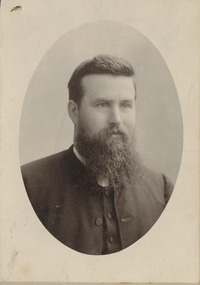
Photograph, Rev. Benjamin Danks, 19th C
Benjamin Danks was b. 1853 England, ordained 1878, and died 1921 in Rookwood, NSW. DANKS, Benjamin (1853-1921) Michael Horsburgh, DANKS, BENJAMIN (b. Wednesbury, England, 12 Feb 1853; d. Sydney, NSW, 12 April 1921). Methodist missionary in New Britain and missionary administrator. Benjamin Danks migrated to Vic with his family when a young child. He entered the Wesleyan Methodist ministry in 1878 and was sent with his wife, Emma, daughter of John and Elizabeth Watsford, to join the Rev George Brown in the newly established missionary venture on the Duke of York group in New Britain, where he remained for nine years. An opponent of 'blackbirding', the traffic in indentured island labour for the Australian sugar cane industry, he warned local inhabitants not to go aboard any vessel recruiting labour for distant places, much to the displeasure of the labour traders. In 1880 he participated in the rescue of the survivors of the ill-fated settlement established by the Marquis de Rays. In 1907 he succeeded George Brown as the general secretary of Foreign Missions for the Methodist Church of Australasia and was president of the NSW Conference in 1908. He retired in 1918 and died in 1921 after a long illness attributed to the privations of his missionary career. Danks was highly regarded as a linguist and published the first book in the Tolai language of New Britain. He was a strong supporter of state legislation to control social evils, and to ensure pure food and drugs. He was an ardent temperance advocate. George Brown, An Autobiography (London, 1908); New South Wales Methodist Conference, Souvenir of the Presidency of the Rev. Benjamin Danks (Sydney, 1909); Wallace Deane (ed), In Wild New Britain (Sydney, 1933); Neville Threlfall, One Hundred Years in the Islands (Rabaul, 1975). MICHAEL HORSBURGH Electronic Version © Southern Cross College, 2004. Content © Evangelical History Association of Australia and the author, 2004.Sepia oval portrait photo of a younger man with wiry beard and moustache, dressed as clergyman.danks, benjamin, new britain -
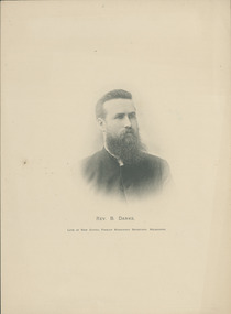 Uniting Church Archives - Synod of Victoria
Engraving, Rev. Benjamin Danks, 19th C
Benjamin Danks was b. 1853 England, ordained 1878, and died 1921 in Rookwood, NSW. DANKS, Benjamin (1853-1921) Michael Horsburgh DANKS, BENJAMIN (b. Wednesbury, England, 12 Feb 1853; d. Sydney, NSW, 12 April 1921). Methodist missionary in New Britain and missionary administrator. Benjamin Danks migrated to Vic with his family when a young child. He entered the Wesleyan Methodist ministry in 1878 and was sent with his wife, Emma, daughter of John and Elizabeth Watsford, to join the Rev George Brown in the newly established missionary venture on the Duke of York group in New Britain, where he remained for nine years. An opponent of 'blackbirding', the traffic in indentured island labour for the Australian sugar cane industry, he warned local inhabitants not to go aboard any vessel recruiting labour for distant places, much to the displeasure of the labour traders. In 1880 he participated in the rescue of the survivors of the ill-fated settlement established by the Marquis de Rays. In 1907 he succeeded George Brown as the general secretary of Foreign Missions for the Methodist Church of Australasia and was president of the NSW Conference in 1908. He retired in 1918 and died in 1921 after a long illness attributed to the privations of his missionary career. Danks was highly regarded as a linguist and published the first book in the Tolai language of New Britain. He was a strong supporter of state legislation to control social evils, and to ensure pure food and drugs. He was an ardent temperance advocate. George Brown, An Autobiography (London, 1908); New South Wales Methodist Conference, Souvenir of the Presidency of the Rev. Benjamin Danks (Sydney, 1909); Wallace Deane (ed), In Wild New Britain (Sydney, 1933); Neville Threlfall, One Hundred Years in the Islands (Rabaul, 1975). MICHAEL HORSBURGH Electronic Version © Southern Cross College, 2004. Content © Evangelical History Association of Australia and the author, 2004.Engraving of Rev. Benjamin Danks based on the portrait."Rev. B. Danks. Late of New Guinea, Foreign Mission Secretary, Melbourne."danks, benjamin, new britain -
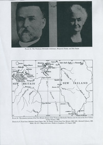 Uniting Church Archives - Synod of Victoria
Photograph, Rev. Benjamin Danks, 19th C
Benjamin Danks was b. 1853 England, ordained 1878, and died 1921 in Rookwood, NSW. DANKS, Benjamin (1853-1921) Michael Horsburgh, DANKS, BENJAMIN (b. Wednesbury, England, 12 Feb 1853; d. Sydney, NSW, 12 April 1921). Methodist missionary in New Britain and missionary administrator. Benjamin Danks migrated to Vic with his family when a young child. He entered the Wesleyan Methodist ministry in 1878 and was sent with his wife, Emma, daughter of John and Elizabeth Watsford, to join the Rev George Brown in the newly established missionary venture on the Duke of York group in New Britain, where he remained for nine years. An opponent of 'blackbirding', the traffic in indentured island labour for the Australian sugar cane industry, he warned local inhabitants not to go aboard any vessel recruiting labour for distant places, much to the displeasure of the labour traders. In 1880 he participated in the rescue of the survivors of the ill-fated settlement established by the Marquis de Rays. In 1907 he succeeded George Brown as the general secretary of Foreign Missions for the Methodist Church of Australasia and was president of the NSW Conference in 1908. He retired in 1918 and died in 1921 after a long illness attributed to the privations of his missionary career. Danks was highly regarded as a linguist and published the first book in the Tolai language of New Britain. He was a strong supporter of state legislation to control social evils, and to ensure pure food and drugs. He was an ardent temperance advocate. George Brown, An Autobiography (London, 1908); New South Wales Methodist Conference, Souvenir of the Presidency of the Rev. Benjamin Danks (Sydney, 1909); Wallace Deane (ed), In Wild New Britain (Sydney, 1933); Neville Threlfall, One Hundred Years in the Islands (Rabaul, 1975). MICHAEL HORSBURGH Electronic Version © Southern Cross College, 2004. Content © Evangelical History Association of Australia and the author, 2004.Photocopy of page from a book (A4 size) with pictures of Danks and Mrs. Danks and a map showing New Britain and New Ireland and the mission stations of the New Britain district of the Wesleyan Methodist Mission and the sites of the Free Colony of New France.danks, benjamin, new britain