Showing 12766 items
matching reserves
-
 8th/13th Victorian Mounted Rifles Regimental Collection
Photograph
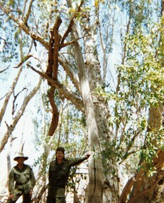
In 1988, as part of a Defence of Mainland Australian policy, defence of facilities of strategic importance in northern Australia were allocated to Army Reserve units. ‘A’ Squadron was allocated the defence of Tindal Air Force base located 15 KM outside Katherine in Northern Territory. Consequently the Squadron deployed on Exercise ‘Northern Explorer’ to gain first-hand knowledge of operating conditions for mounted and dismounted patrolling in the area.Colour photograph of Captain C. Carrington, earing hat, and Sergeant Koschel of ' A ' Squadron 8/13 VMR during Exercise " Northern Explorer." Flood debris caught high in tree branches indicate water level during wet season on Ferguson River, Northern Territory. -
 8th/13th Victorian Mounted Rifles Regimental Collection
Photograph
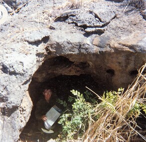
In 1988, as part of a Defence of Mainland Australian policy, defence of facilities of strategic importance in northern Australia were allocated to Army Reserve units. ‘A’ Squadron was allocated the defence of Tindal Air Force base located 15 KM outside Katherine in Northern Territory. Consequently the Squadron deployed on Exercise ‘Northern Explorer’ to gain first-hand knowledge of operating conditions for mounted and dismounted patrolling in the area.Colour photograph of Captain C. Carrington sheltering from 41o sun during Exercise " Northern Explorer." -
 8th/13th Victorian Mounted Rifles Regimental Collection
Photograph
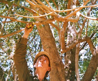
In 1988, as part of a Defence of Mainland Australian policy, defence of facilities of strategic importance in northern Australia were allocated to Army Reserve units. ‘A’ Squadron was allocated the defence of Tindal Air Force base located 15 KM outside Katherine in Northern Territory. Consequently the Squadron deployed on Exercise ‘Northern Explorer’ to gain first-hand knowledge of operating conditions for mounted and dismounted patrolling in the area.Colour photograph of Lance Corporal R. Van. De Velde picking native figs on bank of Ferguson River, Northern Territory during Exercise "Northern Explorer." Soldiers of ' A ' Squadron 8/13 VMR had received instruction of bush food by Major Les Hiddens aka ' The Bush Tucker Man. '100 mm x 100 mm -
 8th/13th Victorian Mounted Rifles Regimental Collection
Photograph
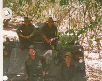
In 1988, as part of a Defence of Mainland Australian policy, defence of facilities of strategic importance in northern Australia were allocated to Army Reserve units. ‘A’ Squadron was allocated the defence of Tindal Air Force base located 15 KM outside Katherine in Northern Territory. Consequently the Squadron deployed on Exercise ‘Northern Explorer’ to gain first-hand knowledge of operating conditions for mounted and dismounted patrolling in the area.Colour photograph of four members of a vehicle patrol of ' A ' Squadron 8/13 VMR at Ferguson River, Northern Territory, during Exercise 'Northern Explorer." -
 8th/13th Victorian Mounted Rifles Regimental Collection
Photograph
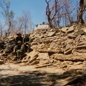
In 1988, as part of a Defence of Mainland Australian policy, defence of facilities of strategic importance in northern Australia were allocated to Army Reserve units. ‘A’ Squadron was allocated the defence of Tindal Air Force base located 15 KM outside Katherine in Northern Territory. Consequently the Squadron deployed on Exercise ‘Northern Explorer’ to gain first-hand knowledge of operating conditions for mounted and dismounted patrolling in the area.Colour photograph of vehicle patrol of ' A " Squadron 8/13 VMR accessing the viability of a crossing point of Ferguson River during Exercise ' Northern Explorer. The patrol decided the Armoured Personnel carrier could descend the shale bank but not climb out again. -
 8th/13th Victorian Mounted Rifles Regimental Collection
Photograph
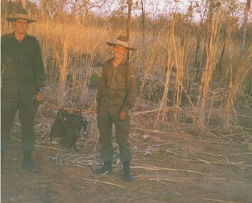
In 1988, as part of a Defence of Mainland Australian policy, defence of facilities of strategic importance in northern Australia were allocated to Army Reserve units. ‘A’ Squadron was allocated the defence of Tindal Air Force base located 15 KM outside Katherine in Northern Territory. Consequently the Squadron deployed on Exercise ‘Northern Explorer’ to gain first-hand knowledge of operating conditions for mounted and dismounted patrolling in the area.Colour photograph of two soldiers of ' A ' Squadron 8/13 VMR during Exercise ' Northern Explorer '. Trooper Pratt and Lance Corporal Van De Valde demonstrate how the F2 radio set could be carried. In addition the men would have webbing, pack and rifle to carry. -
 8th/13th Victorian Mounted Rifles Regimental Collection
Document
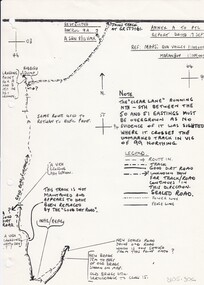
In 1988, as part of a Defence of Mainland Australian policy, defence of facilities of strategic importance in northern Australia were allocated to Army Reserve units. ‘A’ Squadron was allocated the defence of Tindal Air Force base located 15 KM outside Katherine in Northern Territory. Consequently the Squadron deployed on Exercise ‘Northern Explorer’ to gain first-hand knowledge of operating conditions for mounted and dismounted patrolling in the area.Rare example of a patrol report conducted by soldiers of a Victorian Army Reserve regiment while exercising in Northern Territory.Report of reconnaissance patrol conducted by soldiers of 'A' Squadron 8/13 Victorian Mounted Rifles during Exercise 'Northern Explorer, Northern Territory. 13 pages plus sketch map. -
 8th/13th Victorian Mounted Rifles Regimental Collection
Document - Report
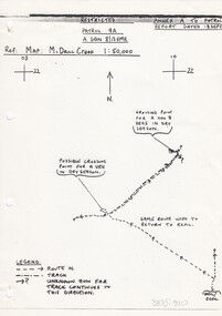
In 1988, as part of a Defence of Mainland Australian policy, defence of facilities of strategic importance in northern Australia were allocated to Army Reserve units. ‘A’ Squadron was allocated the defence of Tindal Air Force base located 15 KM outside Katherine in Northern Territory. Consequently the Squadron deployed on Exercise ‘Northern Explorer’ to gain first-hand knowledge of operating conditions for mounted and dismounted patrolling in the area.Rare patrol report made by soldiers of a Victorian regiment while on exercise in Northern Territory.Report of patrol carried out by soldiers of 'A' Squadron 8/13 Victorian Mounted Rifles 18 September 1988 near Tindal Air Base Northern Territory. Six pages plus sketch map.military, patrol, tindal, northern territory, vmr -
 8th/13th Victorian Mounted Rifles Regimental Collection
Document, September 1988
In 1988, as part of a Defence of Mainland Australian policy, defence of facilities of strategic importance in northern Australia were allocated to Army Reserve units. ‘A’ Squadron was allocated the defence of Tindal Air Force base located 15 KM outside Katherine in Northern Territory. Consequently the Squadron deployed on Exercise ‘Northern Explorer’ to gain first-hand knowledge of operating conditions for mounted and dismounted patrolling in the area.Rare example of an assessment prepared by a trooper in a Victorian Citizen Military Forces regiment during an exercise in Northern Territory.Typed assessment of the performance of armoured vehicles during Exercise "Northern Explorer" in September 1988. Document is titled "A Veh Ops in the Tindal AO" prepared by Trooper D J Pratt 1 Troop A Squadron 8/13 Victorian Mounted Rifles. Three pages dated 22 September 1988. -
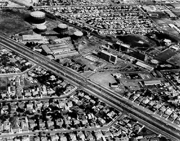 City of Kingston
Photograph - Black and white, c. 1970
The Highett Gas Works were a landmark along the Nepean Highway for many years. With the cessation of the gasification of coal and the introduction of natural gas to Victoria, the gas holders were demolished and the Sir William Fry Reserve was developed on the southern end of the site. The Gas and Fuel redeveloped the northern end of the site with modern offices and laboratories for the organisation's scientific services. At this time, the chimney and retort house were retained.The Highett Gasworks had its beginning in 1939 operated by the Central Brighton and Moorabbin Gas Co Ltd. The company had expanded its gas production facilities to Highett where it had purchased 45 acres of land adjacent to the Melbourne-Frankston railway line. The first gasholder was erected on the Highett site in 1927 and connected with high pressure mains to the Brighton Gas Works. In 1939 the building program including gasometers, the vertical retort house and coal store was completed and gas making commenced. Its area of supply covered approximately 70 square miles and included the municipalities of Brighton, Sandringham, Moorabbin, Mordialloc, Chelsea and part of Dandenong. The Gas and Fuel Corporation eventually took over operations and with the disaggregation and privatisation of the organisation, the site was eventually closed c. 2002.Black and white aerial photograph featuring the Highett Gas Works with gasholders and retort house. In the top right-hand corner, a former Highett Primary School on Graham Road can be viewed. Photograph includes Bay Road, Royal Avenue, Princess Avenue and Jackson Road (Highett) and Alfred, Turner and Sandford Streets (Moorabbin).Handwritten in black ink: [indecipherable] in a circle Handwritten in red ink: 70% Four velcro display adhesivesgasification of coal, gas and fuel corporation of victoria, gasholders, highett, moorabbin, utilities -
 Eltham District Historical Society Inc
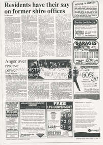
Document - News Clipping, Jodie Guest, Residents have their say on former shire offices, Diamond Valley News, October 16, p9, 1996
Nillumbik Commissioners used 'reserve power's to permit a controversial Shell service station and Hungry Jackls restaurant development at the former Eltham Shire Office site at 895 Main Road. More than 200 people attended the Council meeting in the public gallery and protested at the decision. 32 personal submissions were made to Council's Planning Special Committee meeting whose members vioted 3-2 against the development. The Committee consisted of the three Nillumbik Commissioners and three community members (Jim Connor, Bronwyn South and Janet Mattiske). Chief Commissioner Don Cordell, a former Shell employee excused himself from voting and the three communbity memebrs voted against the submission. The other two commissioners, Vin Heffernan and Kevin Abbott voted against it. They then immediately closed the meeting and opened a Council meeting lasting just seconds to use special reserve powers to overturn the decision. Community residents who made submissions included Russell Yeomans speaking on behalf of the Eltham Gateway Action Group and Eltham District Historical Society, Des Ryan on belaf of Eltham Senior Citizens, Angela Newhouse, others on behalf of Our Lady Help of Christians Primary School and Judge Book Village, Tom Munro, Ian Jennings, Margartet Ball a fifth generation descendant of the Shillinglaw family, one of the early settlers of the area and owner of the land that was sold to Council, Frank Burgoyne who said "there will be a lot of creaking and rumbling in the cemetery if this goes through. So many old people who have done so much for Eltham are buried up there and it is up to us to pass on what they left to the younger generation. Eltham is a beautiful spot; why louse it up?" A second article "Anger over reserve power" by Laeta Antonysen provides commentary from the three Planning Special Committee community members, former Eltham Shire Councillor Jim Connor, Bronwyn South and Janet Mattiske about the process that took place and the first time use of the spoecial reserve power to overturn the decision of the committee. Barry Rochford, Nillumbiuk CEO defends the use of the power.The demolition of the former Shire of Eltham offices and proposed sale and development driven by the Commissioners for Nillumbik Shire Council brought the community together in substantial protest at the infrigement of ratepayers democratic say in local government and ciommunity assets combined with protests about inappropraite development of Eltham's Gateway. This issue led to the formation of the Eltham Community Action Group which still operates strongly today (2023) on behalf of the community to ensure appropriate development within the community.895 main road, commissioners, dallas price homes, development application, eltham hub, hungry jacks, nillumbik shire council, re-zoning, shell service station, town planning, eltham gateway, eltham gateway action group, eltham shire offices, shillinglaw farm, shillinglaw trees, jim connor collection, dallas howgate, nillumbik planning special committee, jim connor, bronwyn south, janet mattiske, don cordell, vin heffernan, kevin abbott, russell yeomans, eltham district historical society, eltham senior citizens, des ryan, our lady help of christians primary school, judge book village, angela newhouse, tom munro, ian jennings, margaret ball, shillinglaw cottage, frank burgoyne, andrew biasci, barry rochford -
 Ringwood and District Historical Society
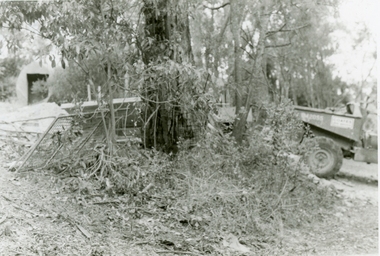
Photographs, 1979-80 MMBW pipe line project at Hubbard Reserve, North Ringwood � Boring mole pit
E560 N5 Dec 1979 A43 Boring mole pit near big box tree in 39 Burlock Avenue backyard Part of a 43-photo record of the MMBW�s engineering feat in drilling a 12 inch pipe line up to 40 feet deep through rock hardened by volcanic action associated with geological fault that occurs along the line. The work took place from October 1979 to May 1980 on the southern boundary of Hubbard Reserve, North Ringwood. The collection was presented to the Ringwood Historical Research Group by J Clarke on 9th June 1980. -
 Ringwood and District Historical Society
Photographs, 1979-80 MMBW pipe line project at Hubbard Reserve, North Ringwood � Cover of mole pit
E560 N24 Jan 1980 A43 Cover of mole pit near big box tree in 39 Burlock Avenue backyard Part of a 43-photo record of the MMBW�s engineering feat in drilling a 12 inch pipe line up to 40 feet deep through rock hardened by volcanic action associated with geological fault that occurs along the line. The work took place from October 1979 to May 1980 on the southern boundary of Hubbard Reserve, North Ringwood. The collection was presented to the Ringwood Historical Research Group by J Clarke on 9th June 1980. -
 Ringwood and District Historical Society
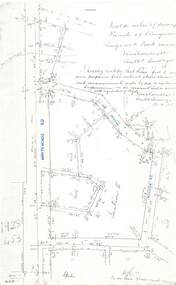
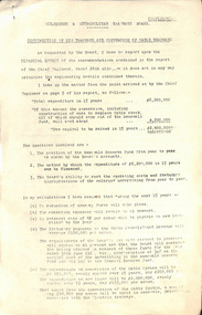
Document - Copy of Lands Department Field Notes - Parish of Ringwood, Victoria, Field Notes - 1928/453 - Part of OP R72C Surveyed on 17.11.1928
5616b Foolscap size photocopy of survey map with handwritten notations. References include Whitehorse Road, Mines Road, Wilson Street, Rupert Street, New Road (Braeside Avenue), Section E, Allot 31 sold, Allot 32 sold, Recreation Reserve, Allot 25 sold, Allot 29 sold, hedge, spikes, links on line from each corner, I hereby certify that these field notes were prepared from actual observations and measurements made by me or under my supervision on the ground and in accord with regulations (signed) Authorised Surveyor 17/11/28. -
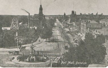 Bendigo Historical Society Inc.
Postcard - BLACK AND WHITE PHOTO OF PALL MALL BENDIGO: EARLY DAYS TO LATE 1800'S
Black and white Photo of Pall Mall Bendigo - early days - late 1800's - postcard -rear of card shows Royal Historical Society of Victoria Bendigo Branch - Hustlers Royal Reserve No.2 Locality; Pall Mall Bendigo RSL Memorial Hall now occupies site. Depth of shaft -1,660 feet, Formed 1885, closed 1917, Poppet legs - steel, 60 feet high. Winding engine: First motion, 24 in. Cylinders, 10ft. Drums. Gold Yield - 10,262 ozs .Dividends 3,200 pounds. / Photo shows Beehive sign.postcard, photograph, bendigo, pall mall bendigo - early days - late 1800's /--hustlers royal reserve no.2 locaility ; pall mall bendigo rsl memorial hall / beehive sign -
 Whitehorse Historical Society Inc.
Photograph, War Memorial Mitcham, C1930
Black and white photo of War Memorial in Whitehorse Road,Mitcham.The much travelled (located and relocated) soldier has been placed n many since the end of WW1:|1. Centre of Whitehorse Road within reserve midway between Mitcham Road and Station Street (see photograph 562)|2. Closer to Mitcham Road and on the garden /lawns between Whitehorse Road (main throughway) and the northern service| road. (see NP562)|3. On his pedestal outside the Memorial Hall on the corner of Whitehorse Road and MacDowall Street.|4. Currently mounted in the gardens of Halliday Park in Mitcham Rd.war memorial mitcham -
Lakes Entrance Regional Historical Society (operating as Lakes Entrance History Centre & Museum)
Photograph, Lakes Post Newspaper, 1990
Black and white photograph of Lakes Football Club Reserves Team members Back: J Forrester, J Lamanna, G Gudgin, P White, S Smythe, L Somerville, P Forrester, D Armistead, P Marsden, Les Prout trainer Middle: D O'Donell runner, C Dostine, T Wykes, R Yates, S Greer, A Adams, S Campisi, D Veal, D Conduit, Front: S Cox, D Svetlik, T Brickle mascot, M McInnes, C Davis premiers 1990 taken after defeating Orbost Lakes Entrance Victoriaclubs, sports -
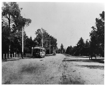 Ballarat Tramway Museum
Photograph - Black & White Photograph/s, The Courier Ballarat, 1907
Yields information about the operation of ESCo trams in Wendouree Parade and the appearance and condition of the roadway at the time.Black and white photograph of Electric Supply Co. tram No. 18 in Wendouree Parade, Gardens Reserve area, to the west of St Aidans Drive - on present BTM track. Tram travelling east, has poles with old style bracket arms, and white wooden posts on lake side. On right side of photograph under trees is a horse drawn cart. From the Ballarat Courier, Christmas supplement of 4-12-1907. Photo features also in postcard - Reg Item 3138. Copy 2 - added 28/7/2007 - from Alan Bradley's collection of photographs, to depot 5/2007.trams, tramways, esco, wendouree parade, ballarat, gardens , tram 18 -
Bendigo Historical Society Inc.
Map - MARKS COLLECTION: TRAMWAY OR RAILWAY MAP SANDHURST
Original map of 'land granted as endowment' for tramway or railway. On top Rh corner of map, in bold print 'Sandhurst, Inglewood & Loddon district Tramway or Railway.Land granted as endowment shaded, scale 60 chains to 1 inch. Lithographed by J & W. Holmes, Lith. Sandhurst'. Signed by Geo Avery Fletcher, Engineer. Map shows Parish of Leichardt, Parish of Yarraberb, Parish of Bridgwater and a section of Marong. On bottom RH corner, is small map of Sandhurst, showing railway reserve. Top LH corner, Inglewood. Map shows route of railway line from Sandhurst to Inglewood. -
 Kew Historical Society Inc
Photograph - Denmark Street, Kew, 1972
The Engineer's Department of the former City of Kew had an extensive collection of photograph of sites in Kew requiring documentation to inform public works. It also kept images of engineering practice in other parts of Melbourne, and overseas, that could be used as models for local activity. Many of these photographs (and plans) were donated to our collection in the 1980s. A number of the photographs are annotated, either on the image itself or on the reverse.This photograph, and others sourced from the City Engineer's Department of the former City of Kew, qualifies as an important record of local streets, public works, street beautification, and engineering techniques of the period. Original black and white photographic positive of automobiles and buildings in Denmark Street, Kew, immediately before the road enters Kew Junction. On the left is McKeon Motors and a retailer of Insulwool, while in the distance is the pharmacy on the corner of High Street and Princess Street (later demolished during the widening of Kew Junction). Notable are the bluestone guttering and what appears to be vacant land on the apex of the triangle of land bounded by High Street South, Denmark Street and Barkers Road. This site was the original location of O'Shaughnessy's 'Kew Hotel', and after the destruction by fire of the latter, the location of a service station. [It is now the site of the Cresco Reserve].Annotation verso: "Indicating the existence of a vehicular entrance at Denmark St abuttal of No.188 High St prior to reconstruction of channeling &c 1972."denmark street -- kew (vic.), kew junction, luestone gutters, mckeon motors, insulwool -
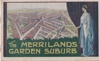 Melbourne Tram Museum
Book, T. M. Burke, "The Merrilands Garden Suburb", late 1919
Book - 12 pages with a fold out double page centre map, centre stapled, titled "The Merrilands Garden Suburb", a real estate marketing brochure for area to the west of the Reservoir rail line, known locally as Merrilands. Marketed on being a gardens suburb to the then Town Planning situation. Contains a suggested loop tram system. Has sales conditions, general information. Marketed by T. M. Burke of 340 Collin St Melbourne. Fold out surveyors map, by Saxil Tuxen, Licensed Surveyor date Oct. 1919. Shows suggested tram routes, reserves, and civic centre.trams, tramways, real estate, reservoir, proposals, new tramway, land -
 Melbourne Tram Museum
Administrative record - Depot List, The Met, "Tram Construction and Maintenance Branch - Allocation of Tramcars 1.7.1986", Jul. 1986
Depot List - 13 A4 sheets, were stapled in top left hand corner, titled "Tram Construction and Maintenance Branch - Allocation of Tramcars 1.7.1986" Sheets 1 to 6 - Allocation of Tramcars in Numerical Order including listing of tramcars for storage and disposal and storage and retention in operating condition to A 272 and artics 2002. Sheets 7 to 12 - allocation by depot including trams in storage at Hawthorn, Approved disposal, future disposal, training trams, tourist trams and special purpose, Ministry of Arts, Decorated trams, Reserve trams. Sheet 13 - Summary of Fleet in Service.trams, tramways, tramcars, mmtb, lists, depots, depot allocation -
 Melbourne Tram Museum
Document - Report, Melbourne & Metropolitan Tramways Board (MMTB), "Construction of new tramways and conversion of cable tramways", 8/05/1922 12:00:00 AM
Report - six foolscap sheets pinned in the top left hand corner, marked confidential, stencil duplicated, titled "Construction of new tramways and conversion of cable tramways" looking at the financial position of the board and the implications of the conversion of cable tramways and construction of new tramways. Signed by W. O Strangward 8/5/1922. Includes analysis of financing the works, the MMTB's ability top meet operating costs and statutory appropriations, loan repayments, construction of new tramcars, over crowding, reserve funds and alternative methods of undertaking the work and meeting the costs of the work. Refers to the Engineers report.trams, tramways, conversion, mmtb, cable trams, finances, new tramway, track construction -
 Federation University Historical Collection
Plan, Ballarat East, 1957
Dr George Clendinning and others were trustees of the Church of England (St Paul's) A number of enlargements of the Ballarat East maps. .4) Bakery Hill, Humffray Street, Victoria Street, Ballarat Youth Council .5) Specimen Vale, Victoria Street, Eureka Street, Housing Commission .10) - Tomber Reserve, York Street, Spencer Street, Bennett Street, Wilson Street, Rodier Street, Richard Street, Fussell Street, Turpie Street, Stockade Street, Ballarat Rifle Range Lal La Street, Clayton Street, Eureka Street Sheet 2 - Yarrowee Creek, High Street, Dinney's Dam, Binney Street, Oliver Street, Humffray Street, Morres Street, Finch Street, Scotts Parade, Rice Street, HOrnby Street, Queen Street, Newman street, King Street, Napier Street, Sim Street. Sheet 3 - Russell Square, Victoria Street, Orphan Asylum, Ballarat Orphanage, Lofven Street, Haines Street, Yarrowee Creek, Ching Who Coey, Chinese, Stawell Street, Rice Street, Lane Street, Humffray Street, Nelson Street, Coffield Street, Morres Street, Western Highway, Rodier Street, Scott Parade, Canterbury Street Sheet 4 - Orphan Asylum, Ballarat Orphanage School, Fortune Street, Scotts Parade, Water Street, Ritchie Street, Humffray Street, Brophy Street, Thompson Street, Victoria Street,Humffray Street Church of England Reserve, Strickland Parade. Mount Xavier Recreation Reserve, Charlesworth Street Catholic Church Reserve. Sheet 5 - Western Highway, Mount Street, Fortune Street, Finlay Street, Jones Street, Ryan Street, Water Street, Brandbury Street, Humffray Street. Sheet 6 - Barkly Street, Ebden Street, Grenville Street, Cameron Street, Peel Street, Young Street, Victoria Street, Steinfeld Street, Haymes Street, Bond Street, Anderson Street, Eastwood Street, Mair Street, East Street, Haymes Crescent Sheet 7 - Murphy Street, Queen Street, Dyte Parade, Princes Street, Midland Highway, York Street, Dodds St, Wilson St Otway Street, Specimen vale, King Street, Gray Street, Little Dodds Street, Eureka Street. Sheet 9 - Richards Street, Fussell Street, Stockade Street, Orphan Asylum, Ballarat Orphanage, Elford Street, Russell Street, Ross Street, Charlesworth Street, Lalor Street, Stockade Street, Wilson Street, York Street, Eureka Street Sheet 10 - Eureka Street, York Street, Elford Street, Wilson Street, Mount Street, Turpie Street, Timber Reserve, Mount Xavier Sheet 11 - Yarrowee Creek, Humffray Street, Barkly Street, Morton Street, Cobden Street, Morton Street Wesleyan Church, Pryor Street, Albion Street, Bradshaw Street, Ballarat Woollen Mills, Tannery, Mount Pleasant. Sheet 12 - Magpie Street, Grant Street, Gladstone Street, Cobden Street, Fraser Street, Grenfell Street, Robertson Street, Bond Street, Barkly Street, Vine Street, Sovereign Hill, Ballarat Observatory, Pearce Street, Bond Street. Sheet 13 - Murphy Street, Larter Street, midland Highway, Geelong Road, gales Street, Lal Lal Street, Clayton Street, Dodds Street, Elsworth Street Sheet 14 - Eureka Street, Eureka Stockade Memorial Park, Eureka Stockade Reserve. York Street, Joseph Street, Kline Street, Charlesworth Street, Chamberlain Street, Trevor Street, Belford Street, Queen Street, Murray Street, Eureka Tiles, Orphan Asylum, Ballarat Orphanage. Sheet 18 - Scotts Parade, Stawell Street, Fortune Street, Victoria STreet, Railway Line, Haines Street, Eureka Street, Elford STreet, Brophy Street, York Street, Clayton Street, Elsworth Street, Barkly Street, Humffray Street, Midland Highway, Princes Street ballarat youth council, ballarat east, bakery hill, humffray street, victoria street, st paul's anglican church, humffray street state school -
 Orbost & District Historical Society
program, Snowy River Mail, 1939
The first meeting to form an Agricultural society in Orbost was convened by the then Orbost Progress Association and held in the Mechanics Hall on Saturday, 10th October 1891. Its first show was held on 3rd March 1904...on a site alongside the Bonang Road where the present Golf Club stands. It is currently held at the Recreation Reserve at Newmerella. Ref: In Times Gone By-Deborah Hall This program is for the 46th annual show in 1939.This item is associated with the Orbost Agricultural Society 's Annual Show which has been a major event in Orbost for over a century. Agricultural shows are an important part of cultural life in small country towns and the Orbost Show is an integral part of Orbost 's agricultural history. A thin grey book with red stripes on the cover. In black print is " 46th Annual Show 1939 Saturday 11th March".orbost-agricultural-show events -
 Orbost & District Historical Society
black and white photograph, Howard D. Bulmer, early 20th century 1920s?
This is a photograph of An Orbost Agricultural Show Committe. The first meeting to form an Agricultural society in Orbost was convened by the then Orbost Progress Association and held in the Mechanics Hall on Saturday, 10th October 1891. Its first show was held on 3rd March 1904...on a site alongside the Bonang Road where the present Golf Club stands. It is currently held at the Recreation Reserve at Newmerella. (Ref: In Times Gone By-Deborah Hall) This photographs is associated with the Orbost Agricultural Society 's Annual Show which has been a major event in Orbost for over a century. Agricultural shows are an important part of cultural life in small country towns and the Orbost Show is an integral part of Orbost 's agricultural history. A large Black / white photograph on grey card. It shows two rows of men. The back row is standing and the front sitting. They are posed in front of a wooden building with an open door. On the left is a water tankon front - Howard D. Bulmer Photographer on right - hand-written < Jack Gilbert X on back - hand-written - L_R Arthur Rodwell, Mat Lynch, Rupert Mosely, S. Lynn, A. Pardew, John Gilbert, John Bird on sticker - "Take off man marked X Mr Matthew Lynch of Orbost"photograph-orbost-agricultural-society -
 8th/13th Victorian Mounted Rifles Regimental Collection
Document - Manning chart
In 1991, the two Army Reserve armoured corps units located in Victoria, 4th/19th Prince of Wales's Light Horse and 'A' Squadron 8th/13th Victorian Mounted Rifles were linked to form a new regiment titled 4/19th Prince of Wales's Light Horse. It comprised two squadrons: VMR Squadron and PWLH Squadron. This document sets out the manning of the latter unit as at the time of linking.Important document relating to a time of significant change in the Army structure in Victoria.Buff coloured card listing A Squadron 8/13 Victorian Mounted Rifles as at March 1991.linking, vmr, pwlh -
 Queenscliffe Maritime Museum
Functional object - Marconi Shed, Geelong Trade School, 2005
Replica shed built in 2005 to house radio equipment for the centenary celebration of the first radio transmission from mainland Australia to Tasmania in 1906. A re-enactment was performed in Royal Reserve between Point Lonsdale and Queenscliff. The replica radio equipment inside was supplied by the Geelong Amateur Radio Club Inc [GARC Inc]. The shed was built by a Geelong Trade School with materials donated by Fagg Bros Pty Ltd.Commemoration of a local historical event.Building, Marconi shedradio transmission, marconi -
 Kew Historical Society Inc
Photograph - Wurundjeri People at Studley Park, before 1855
The Wurundjeri Woi Wurrung People were the original owners of the land on which the City of Boroondara is now located. They made active use of the Yarra for food and transport [an original canoe is held in the collection of the Melbourne Museum]. From 1863, members of the Wurundjeri Woi Wurrung were resettled at the Corranderrk Aboriginal reserve at Healesville. The [now] best known member of the Wurundjeri People was William Barak, who may be pictured here.If the attribution in the annotation is correct, then this may be the earliest photograph of members of the Wurundjeri People at Kew. The photo may be unique.Hand tinted photograph on mounting card of members of the Wurundjeri Woi Wurrung on the banks of the River Yarra, allegedly at Studley Park before 1855 [according to the annotation on the reverse] The photograph of the river and its near and far banks includes two boats on the river, a row boat and a canoe, and people standing on the near bank or seated on the branch of a tree. In addition to men and women of the Wurundjeri People, there appears to be two Europeans pictured, one wearing a hat and the other standing at right. Annotations on the reverse identify a [possible] location and date. [Size: Mount 140 x 215mm | Photograph 125 x 190mm]Various hands and dates: "Original lead pencil lettering Studley Yarra Yarra / Yarra Yarra Studley / Studley (Park?) / Note aboriginals in a bark canoe / Prior 1855 / Very early photo Yarra River originally known as the Yarra Yarra / [illegible part word in ink]".wurundjeri woi wurrung, yarra river, aboriginal and torres straight islander -
 Eltham District Historical Society Inc
Slide - Photograph, Grace Mitchell, Golden Fleece Service Station at the corner of Main Road and Mount Pleasant Road, Eltham, c.1961
View from Grace Mitchell's shop at the corner of Mount Pleasant Road and Main Road. Grace Mitchell was probably best known for her Eltham shop at the corner of Mt Pleasant Road and Main Road. Grace's memories covered many local identities who were patrons of her shop between 1954 and 1971. From the elevated position of her shop and home Grace was able to view a varied passing parade of Eltham events from ERSILAC, Easter and Eltham Festival parades passing on their way to Eltham Lower Park, circuses in Wingrove Park (then Bremner’s Reserve), roadworks and other happenings. Bremner's Reserve was renamed Wingrove Park c.1970 This photo was from a series of images presented by Grace Mitchell at a Society talk 10 March 1993 on the theme of “My Eltham”. The Holden wagon appears to be an FB or EK model with finned rear taillights. The FB was produced January 1960-May 1961 and the EK May 1961 to July 196235mm Kodak 5052 TMX Black and White transparency, 1 strip, 6 frames Black and white print 17 x 25.4 cmgolden fleece service station, main road, mount pleasant road