Showing 2992 items matching "1834-1934"
-
 Glenelg Shire Council Cultural Collection
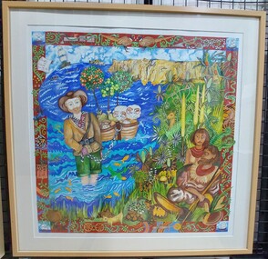
Painting, Jennifer McCarthy, Edward Henty Arrival, 2009
Winner of the 175th Anniversary of Edward Henty landing at Portland, Acquisitive Art Prize.Gouache on paper depiction of Edward Henty's arrival at Portland Bay. Cream coloured mat board. Light coloured wooden frame. Wire hanging cord. A colourful border depicting native animals as well as other items such as a steam train, shovel, cartwheels surrounds an image of the coastline. Each corner of the border shows a sailing ship. In the foreground are two Indigenous Australians seated on the floor surrounded by bushland. To the left stands a man in European clothing - green trousers and a striped top. He is ankle deep in the water. Behind him are two baskets which he holds with a chain. Behind that are two sheep. Top left is a parchment which says, Thistle the Pioneer, Nov 19th 1834.Front: Back - 'Jennifer McCarthy Edward Henty - Arrival 2009' - Brown texta Also framers sticker1834, the thistle, henty, colonial, portland bay -
 Ringwood and District Historical Society
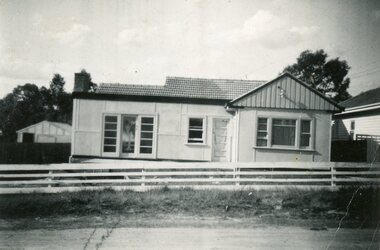
Photograph, House at 28 Georges Road, Ringwood circa 1950s
Photos donated by Dawn Jones. Her in-laws Cath & Len Jones built the house on land subdivided in 1940s. Cath lived there for 75 years and was 97 in March 2024 (time of donation). Their car a 1934 Chrysler iis outside the house. -
 Eltham District Historical Society Inc
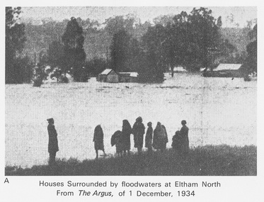
Work on paper (Sub-Item) - Photograph, Houses surrounded by floodwaters at Eltham North
"The house (centre) at North Eltham in which Mr. and Mrs. William Frizell, an elderly couple, were marooned by flood waters. When this photograph was taken late yesterday afternoon the couple were still inside the house, and through a ventilator they had stuck a red flag which they waved from time to time. The house on the left belongs to Mr. Leads, who also was marooned." - The Argus 1 December 1934. John William Frizell, painter and his wife Sarah Jane are registered at Glen Park, Eltham in the 1924 Electorial Roll This was most probably the Diamond Creek in flood. In 1934 extensive flooding of the Yarra River and Diamond Creek sets new records for flood plain level (via Chronology of Eltham, EDHS) flood, frizell, leads, argus, glen park, eltham north, flooding, marooned, diamond creek -
 Glenelg Shire Council Cultural Collection
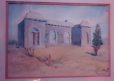
Work on paper - Watercolour, Florence Tatham Mellblom, Portland Shire Hall, n.d
From Antiques Reporter: Florence Tatham Mellblom, (Australian, 1900 - 1983), Visit Portland The First Victorian Settlement, during the Centenary Celebrations from 15th to 23rd November 1934', 1934 colour lithograph, signed 'F. Mellblom' in image lower left, 63.5 x 101.5 cm. Linen-backed. Text continues in lower margin: 'Arbuckle, Waddell Pty Ltd Print, Melb.', Mellblom (nee Henry) was a painter, naturalist and photographer. She was born at Portland, Victoria, and studied art in Ballarat. She was a talented etcher from childhood, and joined the Portland Camera club. She also produced many watercolour paintings of the historic places of Portland. She was married (1932) to Karl Enoch Mellblom.A bluestone building on an arid landscape. Yellow grass in the foreground with one tree standing at the front. There is a blue sky behind. The left hand wing has a door which is slightly open. Above each wing is an engraved piece of stone. Left - Portland, right - Shire. An old rickety fence to the left of the building.Bottom Right - F. Mellblomfemale artist, women, female, landscape, portland landscape, portland shire -
 City of Moorabbin Historical Society (Operating the Box Cottage Museum)
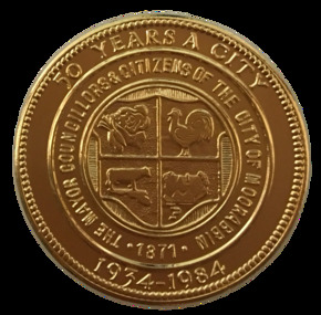
Badge - City of Moorabbin - 50 Years Medal, 1984-85
A gold-plated medal issued by the City of Moorabbin to commemorate the quincentenary of Victoria in 1984-5. It features the City Shield incorporating vegetables, a rooster, a cow and a house, and the sesquicentenary logo. The township of Moorabbin, known as South Brighton until 1909, remained small, with the Plough and Harrow Hotel as its main building. In 1917 Sandringham borough was formed by severance from Moorabbin shire and in 1920 Mentone and Mordialloc were also severed. In the remaining Moorabbin shire the Moorabbin township was still small (1,770 persons), but the shire grew in population during the 1930s. On 10 October 1934 it was proclaimed a city. It existed as a separate municipality until 1995. When local government boundaries were changed in 1994 about half of Moorabbin city was united with Glen Eira city and about half with Kingston city. On 15 December, 1994 the City of Chelsea, parts of the Cities of Mordialloc, Moorabbin, Springvale and Oakleigh were amalgamated to create the City of Kingston by Order of the Governor in Council. On the same day Glen Eira City Council was formed from the City of Caulfield and the remaining part of the City of Moorabbin.Gold Plated Medal Side one: Within a wide rim formed by a line circle, the City Shield incorporating vegetables, a rooster, a cow and a house; around, THE MAYOR COUNCILLORS & CITIZENS OF THE CITY OF MOORABBIN; around on broad rim, 50 YEARS A CITY 1934 - 1984. Side 2: Logo of the Victorian sesquicentenary; below, VICTORIA 150 / GROWING TOGETHER 1984-5 at rim in small letters the mint name, BRIM MELBTHE MAYOR COUNCILLORS & CITIZENS OF THE CITY OF MOORABBIN; VICTORIA 150 / GROWING TOGETHER 1984-5.city of moorabbin, victorian sesquincentenary, moorabbin shire, councillors moorabbin, cheltenham, bentleigh, moorabbin, le page family, cr coates l.r, cr sheppard l.a., cr cooper j.c. -
 Bendigo Historical Society Inc.
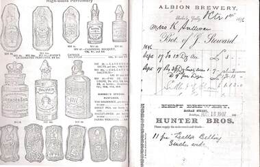
Document - JAMES LERK COLLECTION: BENDIGO CENTRAL BOTTLE CLUB NEWSLETTER
Bendigo Central Bottle Club Newsletter - James Lerk Collection, Vol Vii, No. 2 ca. Nov 1981. Short article on ''History of D Danson & Sons'' Kangaroo Flat 1934- 1948, tomato products. (''Bendigo Valley Products'' and ''Bendigo Best'')Included is a page showing documents from Albion Brewery signed Miss K Sullivan - Bot .of J Steward dated 1.10.1896 and Kent Brewery 18.6.1907. -
 Bendigo Historical Society Inc.
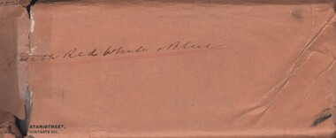
Document - MCCOLL, RANKIN AND STANISTREET COLLECTION: SOUTH RED WHITE AND BLUE - DOCUMENTS, 1933/4
Documents: Envelope contains - 1934 Certificate for wire ropes, Certificates of Inspection of Boiler 1936, 1933 Prospectus, Agreements with Herbert Jackson Leed(South Blue Consolidated), correspondence, 1933 list of applications for shares and related documents, suspension of Labour Covenant for lease 9982, 1933 list of Allotted shares, 1933 hire agreement - Miller & Co machinery for winding engines boiler, air compressor, pump, air receiver.MCCOLL RANKIN AND STANISTREETorganization, business, gold mining - legal, mccoll rankin and stanistreet -
 Canterbury Primary School
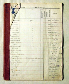
Pupils Register
Great use to Family Historians - contains names, dates, addresses and occupation. Also gives clues to previous location or destination of families.Pupils register covering enrollment years 1931 - 1934. Register numbers 5684 - 6401. Columns include :- Reg.No., Name, DOB, Date of Enrollment, Name of Parent or Guardian, Residence of Parent or Guardian, Occupation of Parent or Guardian, School Last Attended, Date of Last Attendance at former School, Date of obtaining Qualifying Certificate, Date of obtaining Merit Certificate, Date of Last Attendance, Destination. Front cover missingPUPILS REGISTER/STATE ELEMENTARY SCHOOL AT CANTERBURY/No. 3572 However front cover missing.pupils, school, canterbury, register -
 Friends of Ballarat Botanical Gardens History Group
Work on paper - On the Trail of the Lone Pine, Pine Cones from the Gallipoli Battlefield, April - June 2011
Sergeant Keith McDowell gave a cone he collected from Gallipoli to his aunt to try and grow. One seed was planted in the Warrnambool Botanic Gardens and another at the Shrine of Remembrance in Melbourne. These pine trees have symbolic importance as a representation of Australian soldiers' "tenacity and fortitude". They are an important link to the remembrance of those men and women from Ballarat who saw action in World War 1.3 pages (pp.44-46). p.44 in black print on white paper, a photograph of the planting of one of the pines in 1934 at the Australian War Memorial, Canberra. p.45 is a coloured picture of the pine in Canberra. p46 has a history of the seeds brought from Gallipoli by Smith and Mcdowell on the right-hand side of the page and a photograph of the Pines being labelled. There is a column about these trees down the left-hand side of the page.None john garner, doctor, john garner collection, ballarat botanical gardens, friends of the ballarat botanical gardens, the lone pine, gallipoli, anzacs, sergeant keith mcdowell, lance corporal benjamin smith, aleppo pine, turkish pine, pinus halepensis, pinus brutia, gardens, ballarat -
 Bendigo Historical Society Inc.
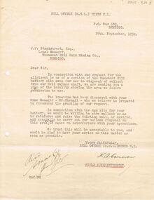
Document - MCCOLL, RANKIN AND STANISTREET COLLECTION: NELL GWYNNE MINES LETTER
Letter to J.J. Stanistreet, Legal Manager, Monument Hill Gold Mining Co., Bendigo from Nell Gwynne Mines N.L., dated 26th September 1934. Letter in connection with our request for the allotment to us of a section of the Monument Hill battery site area for use in disposal of mullock from our Nell Gwynne shaft. Mentions raising wall of existing wall of dam. Plan of the locality attached. See 2205.846.bendigo, business, nell gwynne mines n.l. -
 Port Fairy Historical Society Museum and Archives
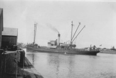
Photograph, TSS Coramba
Used primarily for shipping freight between Port Fairy and Melbourne, the Coramba was lost off Phillip Island during a storm on 30th November 1934. Her location was not discovered until 29th May 2011. This photograph is unique because it shows the ship using the turning basin in the Moyne River.B&W photograph ship, boat, sea, river -
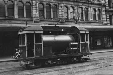
 Melbourne Tram Museum
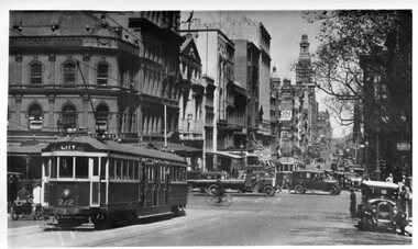
Photograph - Black and White - W Class Tram 272 in Collins St at Swanston St - no route number boxes, Circa 1930
Photograph of tram W 272 in Collins St looking west at Swanston Street. It is noted that it has no destination route boxes. Geoff Warburton notes say it received its route number box during May 1934 and it was sold in March 1980 to Seattle. USA. Not sure where it is now. Early photo of W tram without route number boxes.Black and white photograph slightly curled of W Class Tram 272 in Collins St at Swanston St . Note: No route number boxes.tramways, mmtb, traffic, trams, w class, tram 272, collins st. -
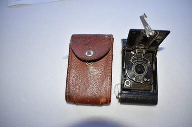 Warrnambool and District Historical Society Inc.
Camera, Black rectangular Kodak with case, 1925-1935
This camera was known as the Vest Pocket camera the earliest models of which were first manufactured in 1912-1914. The later model which was made from 1915 was very successful, selling 1.75 million units and was used during the First World War. This particular model was manufactured from 1925-1934 This camera has significance being one of the earliest made which made photography accessible to a much section of the community..1 Black rectangular camera with rounded ends and white metal fittings. There is a hinged back which when opened reveals a circular section with a folding bed behind.A metal hinged screw is on the left side The other side has a small circular red inset and a movable metal section. .2 Dark tan leather case, rectangular in shape with rounded edges.It closes with a silver metal clasp. There are two slits in the opposite end possibly for strap.There is a sunburst stamped into both sides of the case and it is stitched with coarse cotton thread..1 On outside of camera " Use Film No A127" Inside hinged Back, " made In USA by Eastman Kodak Co Rochester NY 27323 Vest Pocket Camera Model B .2 Kodak is stamped in the leather above the fastener. warrnambool, kodak, eastman kodak camera, vest pocket kodak model b -
 Greensborough Historical Society
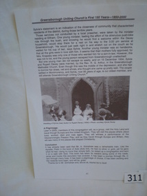
Article, Book, The Greensborough Uniting Church's first 150 years - 1850-2000, 1850-2000
This page deals with some of the history of the Greensborough Uniting Church as told by Sylvia Davey (nee Sutton). The photograph is of Sylvia and her new husband leaving the Greensborough Methodist Church after their marriage in 1934. The small newspaper clipping celebrates Sylvia's 90th birthday (circa 1994) and was written by Rosalie Bray.Contains anecdotes about the early days of the Uniting (Methodist) Church in Greensborough.One page article, including photograph, copied from book. Includes newspaper clipping about Sylvia Davey, the bride in the photograph.On newspaper clipping "by Rosalie Bray"greensborough methodist church, greensborough uniting church, sylvia davey, sylvia sutton, rosalie bray -
 Melbourne Tram Museum
Photograph - Scrubber No 8 Elizabeth St, Johh Buckland, c1940
Photo shows MMTB Scrubber or Track Cleaner No. 8 in Elizabeth St. Tram was built at Preston Workshops in 1934 using cabins from C class No. 32. The tram was withdrawn in 1990 and was donated to the Ballarat Tramway Museum by Public Transport Commission Sept. 1999. Photo by John Buckland c1940.Yields information about MMTB Scrubber trams.Black and white on plain paper.tramways, trams, scrubber 4, elizabeth st -
 Healesville and District Historical Society
Newsletter (Item) - Volume 1; No. 5, Healesville History News, January 1985, November-1984
Contents: Return of the aborigines "Barak" and the purchase by Worowa for a college Unveiling Joseph Furphy Memorial 1934 Test transmission Community Radio Council defers writing of Healesville history funding End of the Line Railway joint activity List of members January 1985 Photograph exhibition success - Plus moreThe first newsletter of the Society was issued July 1984 and has been published continuously ever since on a quarterly basis. The collection provides a valuable resource about the Society's activities, office bearers and committee members and, especially, many relevant items of local historical interest. -
 Healesville and District Historical Society
Newsletter (Item) - Volume 1; No. 6, Healesville History News, February 1985, November-1984
Contents: Return of the aborigines "Barak" and the purchase by Worowa for a college Unveiling Joseph Furphy Memorial 1934 Test transmission Community Radio Council defers writing of Healesville history funding End of the Line Railway joint activity List of members January 1985 Photograph exhibition success - Plus moreThe first newsletter of the Society was issued July 1984 and has been published continuously ever since on a quarterly basis. The collection provides a valuable resource about the Society's activities, office bearers and committee members and, especially, many relevant items of local historical interest. -
 Warrnambool and District Historical Society Inc.
Documents, Sheet Music Back to Warrnambool Song, 1930
This is the original manuscript for the song ‘Back to Warrnambool’, composed for the ‘Back To’ celebrations in Warrnambool in 1930 and reprinted for the ‘Back To’ celebrations in 1934. The song, described as a ‘souvenir foxtrot’ was written by Reginald Stoneham, a professional musician who was engaged to write the song. Reginald Stoneham (1879-1942) was a composer who was Australia’s leading exponent of jazz and ragtime piano styles in the first decades of the 20th century. He composed many tunes for anniversaries and celebrations in country towns and cities in Victoria. The original ‘Back to Warrnambool’ music was given to Henri Worland, the Town Clerk of Warrnambool in 1930 and handed over to the Warrnambool and District Historical Society by Keith Arnel, the Town Clerk in 1973. Note that the original song was ‘Respectfully dedicated to the Pioneers of Warrnambool’. This dedication, for some reason, was not printed on the music issued in the ‘Back To’ programs of either 1930 or 1934. This is a significant item as the song ‘Back to Warrnambool’ has great historical significance as it was popular in Warrnambool in the 1930s and 40s and is still played and sung occasionally today. It is one of the two local songs about Warrnambool composed by Reginald Stoneham. The other is the Warrnambool Waltz Song. It is of interest to historians and researchers to have the original music.This is the original handwritten manuscript of the song, ‘Back to Warrnambool’. There are two pages of pre-ruled music score papers, filled in on both sides of the paper. The paper is marked ‘Boomerang Brand No2’. The musical notes and the words of the song are in black ink. The name of the song is outlined in red ink. The first page has the heading ‘Souvenir Foxtrot Song, Back to Warrnambool, Words and Music composed by Reginald Stoneham, 1930, Respectfully dedicated to the Pioneers of Warrnambool’. The last page has the signature of Reginald Stoneham. The first page has the signature of Henri Worland. warrnambool, reginald stoneham, back to warrnambool -
 Kew Historical Society Inc
Photograph - Yarra Valley Floods: Kew East, 1916
Flooding of the Yarra Valley, including that section of the Yarra bordering Kew and Kew East in the north and west of the municipality, was a regular occurrence. Extreme flood events of the Yarra River are recorded to have occurred in 1891, 1901, 1916, 1923 and 1934. The Municipality of Kew's response to these floods was to enact planning decisions restricting residential development in flood prone areas following the floods of 1916, 1921 and 1934. While floods continued after the development of the Upper Yarra Reservoir (construction 1948-57), the regularity and extent of these inundations diminished. During the nineteenth century, the land abutting the south side of the Yarra in Kew was devoted to dairy farming. In the twentieth century, before and after the construction of the Eastern Freeway, much of this low-lying area was used as golf courses and public parks.One of a collection of photographs of flooding in the Kew section of the Yarra Valley which are in important research resource for the location and extent of flooding in the first half of the twentieth century. Flooding of the Yarra Valley at East Kew in 1916. The view is taken from the intersection of Kilby Road with what is believed to be Birdwood Street, looking across the flood waters to Ivanhoe. The extensive flooded area shown in the photograph would have included the Kew Golf Club. Verso: "Floods along Kilby Road / near Birdwood St? & Kilby Road / 1917? / 87yarra river, yarra valley, floods -- kew, kilby road -- kew (vic.), kew golf club -
 Kew Historical Society Inc
Photograph - Yarra Valley Floods: Kew East, 1916
Flooding of the Yarra Valley, including that section of the Yarra bordering Kew and Kew East in the north and west of the municipality, was a regular occurrence. Extreme flood events of the Yarra River are recorded to have occurred in 1891, 1901, 1916, 1923 and 1934. The Municipality of Kew's response to these floods was to enact planning decisions restricting residential development in flood prone areas following the floods of 1916, 1921 and 1934. While floods continued after the development of the Upper Yarra Reservoir (construction 1948-57), the regularity and extent of these inundations diminished. During the nineteenth century, the land abutting the south side of the Yarra in Kew was devoted to dairy farming. In the twentieth century, before and after the construction of the Eastern Freeway, much of this low-lying area was used as golf courses and public parks.One of a collection of photographs of flooding in the Kew section of the Yarra Valley which are in important research resource for the location and extent of flooding in the first half of the twentieth century. Flooding of the Yarra Valley at East Kew in 1916. The view is taken from a street (maybe Birdwood Avenue) intersecting with Kilby Road looking northeast across the flood waters to Ivanhoe and Heidelberg. The extensive flooded area shown in the photograph would have included remnant dairy farms and the Kew Golf Club. Verso: "Floods / Yarra River / East Kew / Kilby Road / 1917? / 87"yarra river, yarra valley, floods -- kew, kilby road -- kew (vic.), kew golf club -
 Kew Historical Society Inc
Photograph - Flooding of the Yarra Valley at Kew East, 1974
Flooding of the Yarra Valley, including that section of the Yarra bordering Kew and Kew East in the north and west of the municipality, was a regular occurrence. Extreme flood events of the Yarra River are recorded to have occurred in 1891, 1901, 1916, 1923 and 1934. The Municipality of Kew's response to these floods was to enact planning decisions restricting residential development in flood prone areas following the floods of 1916, 1921 and 1934. While floods continued after the development of the Upper Yarra Reservoir (construction 1948-57), the regularity and extent of these inundations diminished. During the nineteenth century, the land abutting the south side of the Yarra in Kew was devoted to dairy farming. In the twentieth century, before and after the construction of the Eastern Freeway, much of this low-lying area was used as golf courses and public parks.Late example of the capacity of the Yarra Valley at Kew to flood, even though drainage works and the Upper Yarra Reservoir had reduced their regularity.Original black and white print photograph of the low-lying land at East Kew under floodwater on 16 May 1974. The vantage point of the photographer is Lister Street. In the photo, the fences of the Kilby Farm can be seen. Flooding was caused by overflowing water in Glass' Creek and the River Yarra. Annotation verso: "Hay's Paddock op No.30 Lister Street / 16 May 1974 11.50am / R.L. 46.04"hays paddock, floods, yarra river, glass' creek, lister street -
 Kew Historical Society Inc
Photograph - Flooding of the Yarra Valley at Kew East, 1974
Flooding of the Yarra Valley, including that section of the Yarra bordering Kew and Kew East in the north and west of the municipality, was a regular occurrence. Extreme flood events of the Yarra River are recorded to have occurred in 1891, 1901, 1916, 1923 and 1934. The Municipality of Kew's response to these floods was to enact planning decisions restricting residential development in flood prone areas following the floods of 1916, 1921 and 1934. While floods continued after the development of the Upper Yarra Reservoir (construction 1948-57), the regularity and extent of these inundations diminished. During the nineteenth century, the land abutting the south side of the Yarra in Kew was devoted to dairy farming. In the twentieth century, before and after the construction of the Eastern Freeway, much of this low-lying area was used as golf courses and public parks.Late example of the capacity of the Yarra Valley at Kew to flood, even though drainage works and the Upper Yarra Reservoir had reduced their regularity.Original black and white print photograph of the low-lying land at East Kew under floodwater on 16 May 1974. The vantage point of the photographer is Lister Street. Flooding was caused by overflowing water in Glass' Creek and the River Yarra. Annotation verso: "Lister Street looking north / Flood level / 16 May 1974 11.30am / R.L. 46.04"hays paddock, floods, yarra river, glass' creek, lister street -
 Kew Historical Society Inc
Photograph - Flooding of the Yarra Valley at Kew East, 1974
Flooding of the Yarra Valley, including that section of the Yarra bordering Kew and Kew East in the north and west of the municipality, was a regular occurrence. Extreme flood events of the Yarra River are recorded to have occurred in 1891, 1901, 1916, 1923 and 1934. The Municipality of Kew's response to these floods was to enact planning decisions restricting residential development in flood prone areas following the floods of 1916, 1921 and 1934. While floods continued after the development of the Upper Yarra Reservoir (construction 1948-57), the regularity and extent of these inundations diminished. During the nineteenth century, the land abutting the south side of the Yarra in Kew was devoted to dairy farming. In the twentieth century, before and after the construction of the Eastern Freeway, much of this low-lying area was used as golf courses and public parks.Late example of the capacity of the Yarra Valley at Kew to flood, even though drainage works and the Upper Yarra Reservoir had reduced their regularity.Original black and white print photograph of Hay's Paddock under floodwater on 16 May 1974. The vantage point of the photographer is Keystone Crescent looking east. Flooding was caused by overflowing water in Glass' Creek and the River Yarra. Annotation verso: "Keystone Cr looking east / 16 May 1974 11.50am"hays paddock, floods, yarra river, glass' creek -
 Kew Historical Society Inc
Photograph - Flooding of the Yarra Valley at Kew East, 1974
Flooding of the Yarra Valley, including that section of the Yarra bordering Kew and Kew East in the north and west of the municipality, was a regular occurrence. Extreme flood events of the Yarra River are recorded to have occurred in 1891, 1901, 1916, 1923 and 1934. The Municipality of Kew's response to these floods was to enact planning decisions restricting residential development in flood prone areas following the floods of 1916, 1921 and 1934. While floods continued after the development of the Upper Yarra Reservoir (construction 1948-57), the regularity and extent of these inundations diminished. During the nineteenth century, the land abutting the south side of the Yarra in Kew was devoted to dairy farming. In the twentieth century, before and after the construction of the Eastern Freeway, much of this low-lying area was used as golf courses and public parks.Late example of the capacity of the Yarra Valley at Kew to flood, even though drainage works and the Upper Yarra Reservoir had reduced their regularity.Original black and white print photograph of the low-lying land at East Kew under floodwater on 16 May 1974. The vantage point of the photographer is Lister Street. Flooding was caused by overflowing water in Glass' Creek and the River Yarra. Annotation verso: "Lister St looking same as No.3 / 16 May 1974 11.30"floods, yarra river, glass' creek, lister street -
 Kew Historical Society Inc
Photograph - Flooding of the Yarra Valley at Kew East, 1974
Flooding of the Yarra Valley, including that section of the Yarra bordering Kew and Kew East in the north and west of the municipality, was a regular occurrence. Extreme flood events of the Yarra River are recorded to have occurred in 1891, 1901, 1916, 1923 and 1934. The Municipality of Kew's response to these floods was to enact planning decisions restricting residential development in flood prone areas following the floods of 1916, 1921 and 1934. While floods continued after the development of the Upper Yarra Reservoir (construction 1948-57), the regularity and extent of these inundations diminished. During the nineteenth century, the land abutting the south side of the Yarra in Kew was devoted to dairy farming. In the twentieth century, before and after the construction of the Eastern Freeway, much of this low-lying area was used as golf courses and public parks.Late example of the capacity of the Yarra Valley at Kew to flood, even though drainage works and the Upper Yarra Reservoir had reduced their regularity.Original black and white print photograph of the low-lying land at East Kew under floodwater on 16 May 1974. The vantage point of the photographer is at Willsmere Road. The road itself is underwater.Annotation verso: "Willsmere Rd / Same as No.7 / 16 May 1974 11.15am"floods, yarra river, willsmere road -
 Kew Historical Society Inc
Photograph - Flooding of the Yarra Valley at Kew East, 1974
Flooding of the Yarra Valley, including that section of the Yarra bordering Kew and Kew East in the north and west of the municipality, was a regular occurrence. Extreme flood events of the Yarra River are recorded to have occurred in 1891, 1901, 1916, 1923 and 1934. The Municipality of Kew's response to these floods was to enact planning decisions restricting residential development in flood prone areas following the floods of 1916, 1921 and 1934. While floods continued after the development of the Upper Yarra Reservoir (construction 1948-57), the regularity and extent of these inundations diminished. During the nineteenth century, the land abutting the south side of the Yarra in Kew was devoted to dairy farming. In the twentieth century, before and after the construction of the Eastern Freeway, much of this low-lying area was used as golf courses and public parks.Late example of the capacity of the Yarra Valley at Kew to flood, even though drainage works and the Upper Yarra Reservoir had reduced their regularity.Original black and white print photograph of the low-lying land at East Kew under floodwater on 16 May 1974. The photograph is of Hyde Park looking north-east.Annotation verso: "Hyde Park looking nth-east / Flood Level / 16 May 1974 11.15am / R.L. 46.61"floods, yarra river, hyde park -
 Kew Historical Society Inc
Photograph - Flooding of the Yarra Valley at Kew, 1974
Flooding of the Yarra Valley, including that section of the Yarra bordering Kew and Kew East in the north and west of the municipality, was a regular occurrence. Extreme flood events of the Yarra River are recorded to have occurred in 1891, 1901, 1916, 1923 and 1934. The Municipality of Kew's response to these floods was to enact planning decisions restricting residential development in flood prone areas following the floods of 1916, 1921 and 1934. While floods continued after the development of the Upper Yarra Reservoir (construction 1948-57), the regularity and extent of these inundations diminished. During the nineteenth century, the land abutting the south side of the Yarra in Kew was devoted to dairy farming. In the twentieth century, before and after the construction of the Eastern Freeway, much of this low-lying area was used as golf courses and public parks.Late example of the capacity of the Yarra Valley at Kew to flood, even though drainage works and the Upper Yarra Reservoir had reduced their regularity.Original black and white print photograph of the low-lying land at East Kew under floodwater on 16 May 1974. The photograph is taken from 43 Kellett Grove.Annotation verso: "Kellett Gve No.43 / Flood Level / 16 May 1974 11.40am"floods, yarra river, kellett grove -
 Melbourne Legacy
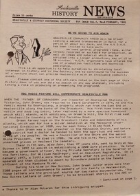
Booklet, The National War Memorial of Victoria (S3), 1939
A booklet produced about the Shrine of Remembrance. This is the 4th edition from April 1939 was revised from the original published in 1934. Part of the booklet is called "An Interpretive Appreciation" by Ambrose Pratt. It describes the parts the Shrine and some of its history. The other half is called "Historical Record" by John Barnes. It contains the full programme of the Dedication of the Shrine by the Duke of Gloucester in 1934 and photos of key aspects of the Shrine. Item was with other photos and programmes from different items relating to the Shrine of Remembrance - including discussions on its location and design. Labelled 'Shrine of Remembrance S1 - S14' it was part of an old archive numbering system, that showed there has been efforts in the past to collect, order and save items of Legacy's history. (01181 - 01190, 01206 - 01211, 01649, 01650).Details of the Shrine of Remembrance published for the public. It is important to note it mentions that Legacy had an important role in promoting the construction of the original design over alternate proposals (of a civic square or a hospital). There was an effort to record historical events for the "Archive Committee" which collected this and other documents relating to the Shrine together in a file (see items 01181 - 01190, 01206 - 01211, 01650).A 44 page of booklet describing for the Shrine, buff paper in a dark grey brown cover with black and white photos and black print.Handwritten on top right corner of the cover is S3 in red pen, part of an original numbering system.memorial, shrine of remembrance -
 Learmonth and District Historical Society Inc.
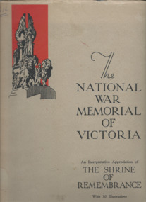
Addington photo, Addington Monument
This Monument was erected in1934,to commemorate the Centenary of the Addington district and its pioneering families. A memorial to the Aborigines in the form of a boomerang was at that time placed on a tree and later resited on the monument. Commemorating the Addington Pioneering families.A monument to commemorate the Centenary of Addington district,erected in memory of each pioneer family.A memorial in memory of the Aborigines in the Shape of a boomerang was placed on a tree at the same time. Over the years the tree died, the boomerang was resited and placed on the monument. (Boomerang)'' IN MEMORY OF THE BLACKS" (Plaque 1) " ERECTED BY A.J. BESELER IN 1994, RESITED BY LEARMONTH AND DISTRICT HISTORICAL SOCIETY UNVEILED ON 1-4-1990 BY Cr.A.R. McDONALD BALLARAT SHIRE PRESIDENT". (Plaque 2) " ERECTED TO THE MEMORY OF THE PIONEERS OF ADDINGTON 1934".1934, addington pioneer monument -
 Ballarat Clarendon College
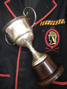
Uniform, Blazer
Ballarat College Sports Under 16 Championship trophy awarded to A C Urquhart 23.9.1935. Angus Campbell Urquhart (1937) entered Ballarat College in 1934. He passed away in 1982 and his son Jim (1971) has offered Angus' 1935 blazer and Under 16 Champion trophy to school uniform, trophy, sports, 1930s, ballarat college, blazer