Showing 1838 items matching "1888"
-
 Melbourne Legacy
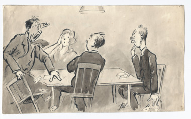
Drawing, Card players drawn by Pat Hanna, 1955
A cartoon drawing done by artist Pat Hanna and sent to friends at Legacy. It looks like a funny caption is missing from the drawing. It was stored with other items including a letter to Frank (possibly L/- Frank Doolan who was making an attempt to collect items relevant to Legacy's history for an official archive project - see items 01400 to 01404). Pat Hanna was an entertainer, comedian, artist and producer of reveues, plays and movies. One of his first revues was performed in France just after the armistice. A popular stage show was 'Diggers' that performed around Australia post-war and adapted into a film in 1931. He was asked to pose for photographer Jack Cato for the iconic image of a digger shown in 01400. He was born George Patrick Hanna, 18 March 1888 in Whitianga, New Zealand and served in the First World War, was a founding member of Melbourne Legacy and was involved with Legacy for many years.Pat Hanna was a founding member of Melbourne Legacy and an artist and producer. Legacy kept some of his works in the archive.Cartoon drawing of a four people playing cards signed Pat (Hanna).Signed 'Pat'hanna, founding legatee, cartoon -
 Warrnambool and District Historical Society Inc.
Financial record - Document, Swinton Employee Assurance, 1947
These documents come from the Warrnambool business of Swintons Pty Ltd. They are 1947 life insurance documents related to the insuring of Swinton employees, payable following retirement or death. William and Ann Swinton migrated to Australia in 1854 and for a decade William Swinton worked as a builder and carpenter in the Warrnambool area, erecting many buildings, including the Wangoom Presbyterian Church. In 1865 he opened a store in Timor Street, Warrnambool, selling groceries, glassware, china and hardware. By 1888 the business was known as William Swinton and Sons. Branch stores were opened in Cudgee, Nullawarre, Wangoom, West Warrnambool and South Warrnambool. Following William Swinton’s death his son Robert became the first managing director of Swintons Pty Ltd. In 1934 the business split with George Swinton and Sons selling furnishings, clothing and glassware and Swintons Pty Ltd selling seeds, produce and hardware. Today the Swinton family still operates a furniture and bedding store in Timor Street. These documents are of interest as they contain information on the insurance policies taken out by Swintons Pty Ltd on behalf of their employees. The current Swinton business in Timor Street is the oldest family business in Warrnambool and, with the name Swinton associated with businesses in Timor Street for 152 years, it is amongst the oldest family business in Australia. .1 This is a document in four parts concerning the insurance for employees of Swintons Pty Ltd. in 1947. The pages are copies and have both printed and typed material .2 This is a policy document, a sheet of paper folded in two to make four pages of printed and typed material. It is a copy. The first page has a red seal.swinton family warrnambool, history of warrnambool -
 Eltham District Historical Society Inc
Document - Folder, Scarce, Henry and others
Henry Scarce of Suffolk worked on John Dickson's farm "Gulf Station", Yarra Flats, then in 1849 settled at Kangaroo Ground. Contents Letter J Scarce to Eltham Historical Society, 19 April 1976 seeking information on Henry Scarce. Letter Eltham Historical Society to J Scarce, 10 June 1976, proving information on Henry Scarce. Photocopy of photograph: Smith family, Panton Hill, 1894, identifying Florry, later Mrs Scarce. Handwritten notes by Joy Ness, undated: Extracts from "Victoria and its Metropolis 1888" and "Victorian Post Office Directory" and other notes regarding Henry Scarce. Handwritten notes, undated, no author: Notes on Scarce family. Letter from Norma Lawler, undated (earlier page/s not present). Request for information on woman (presumably named in earlier page/s) who came from Kangaroo Ground to Eltham in the 1900s. Newspaper clippings, A4 photocopies, etchenry scarce, kangaroo ground, florry scarce (nee smith), vera jackson, henry john (jack) scarce, john jardine scarce, thomas scarce, keith scarce, kangaroo ground school, john dickson, gulf station, john bell, "violet bank" kangaroo ground, "the hall" kangaroo ground, "kiata" kangaroo ground, "woodlands" kangaroo ground, "pigeon bank" kangaroo ground, e h cameron, mrs p d coysh, mrs v wippill, bob meadows, jack jarrold, john jardine, thomas jardine, "garden hill" kangaroo ground, edward haughton, "coorie bank" kangaroo ground, margaret charlton -
 Warrnambool and District Historical Society Inc.
Financial record - Ledger, Cash Book Swinton's Store, Early 20th century
This is a cash book from the business of William Swinton and Sons. The entries list stock, financial assets, deeds and insurance policies from 1902 to 1911. William and Ann Swinton migrated to Australia in 1854 and for a decade William Swinton worked as a builder and carpenter in the Warrnambool area, erecting many buildings, including the Wangoom Presbyterian Church. In 1865 he opened a store in Timor Street, Warrnambool, selling groceries, china, glassware and hardware. By 1888 the business was known as William Swinton and Sons. Branch stores were opened in Cudgee, Nullawarre, Wangoom, South Warrnambool and West Warrnambool. After William died his son Robert became the first managing director in 1913 of Swintons Pty Ltd. In 1934 the business split, with George Swinton and Sons selling furnishings, clothing and glassware and Swintons Pty Ltd selling seeds, hardware and produce. Today the Swinton family still operates a furniture and bedding shop in Timor Street. This cash book is of considerable interest as a business document of William Swinton and Sons. The entries for the early 20th century give details of business stock and finances and will be very useful to researchers. The current Swinton business in Timor Street Warrnambool is the oldest family business in Warrnambool and, with the Swinton name associated with businesses in Timor Street for 152 years, it is one of the oldest family businesses in Australia.This is a hard cover book of 96 pages with a dark green cover and red leather trimmings on the spine and cover corners. There is gold lettering on the spine. The insides of the cover have a green and brown mottled patterning and the page edges have a multi-coloured mottled patterning. The pages have printed ruled red lines. The entries are handwritten in black ink. There are five loose sheets. ‘Cash Book’ swinton family warrnambool, history of warrnambool -
 Eltham District Historical Society Inc
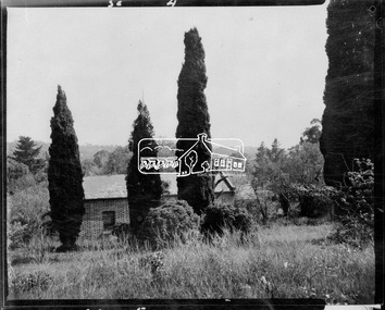
Negative - Photograph, Shillinglaw Cottage, 17 Oct. 1963
Shilinglaw Cottage in its original location on Main Road Eltham with the three Mediterranean Cypress trees (“Shillllinglaw trees”) in the garden. Note a fourth pine to the right. This image was taken shortly before its relocation. Believed to be have been taken by John Collins, 17 Oct 1963 as per other images held by the State Library of Victoria Author / Creator: John T Collins 1907-2001 , photographer. J.T. Collins Collection, La Trobe Picture Collection, State Library of Victoria. Shillinglaw Cottage is significant to Eltham’s local history. It is one of the earliest known buildings still in existence. Records suggest that the cottage was built circa 1859 by a man named Cochrane, believed to be Thomas Cochrane, in conjunction with George Stebbings though it is not known what Stebbings’s contribution was. It is made from hand made bricks laid in a Flemish bond pattern. In the 1960s it was marked for demolition to make way for the construction of new council buildings but a community campaign saved the cottage and it was re-located. It is believed Stebbings owned the cottage between 1874 and 1888. According to Margaret Ball’s (2017) book Shillinglaw Family of Eltham 1660-2007, Thomas Cochrane and family lived there from 1867 to 1874 however this is contrary to the records of assessable rates levied by the Eltham District Road Board, established in 1858, which shows Cochrane was the owner occupier (in Little Eltham) of approximately 25 acres of cultivated land and 25 acres of pastureland upon which a hut was sited in 1860. It is suspected that George Stebbings may have acquired the property from Cochrane in 1874 as it is noted that he had a tenant for a period, James Rossiter, who was the editor for the Evelyn Observer in Kangaroo Ground in 1874 (LATE SHIRE OFFICE AT KANGAROO GROUND (1934, February 16). Advertiser (Hurstbridge, Vic. : 1922 - 1939), p. 5. Retrieved February 25, 2022, from http://nla.gov.au/nla.news-article56743657). In 1881 Phillip Shillinglaw became the ratepayer for the cottage though Stebbings retained ownership until 1888 at which time it was transferred to Shillinglaw.Shillinglaw Cottage is itself historically, aesthetically and socially significant to the Shire of Nillumbik and is registered on the Victorian Heritage Database. This photo forms part of a collection of photographs gathered by the Shire of Eltham for their centenary project book, "Pioneers and Painters: 100 years of the Shire of Eltham" by Alan Marshall (1971). The collection of over 500 images is held in partnership between Eltham District Historical Society and Yarra Plenty Regional Library (Eltham Library) and is now formally known as 'The Shire of Eltham Pioneers Photograph Collection.' It is significant in being the first community sourced collection representing the places and people of the Shire's first one hundred years.Digital image 4 x 5 inch B&W Negsepp, shire of eltham pioneers photograph collection, eltham, shillinglaw cottage, significant tree -
 Parks Victoria - Point Hicks Lightstation
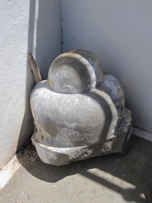
Corbel
In architecture a corbel serves a decorative as well as structural function as a solid piece of stone, wood or metal that is built into a wall and juts out like a bracket to carry a weight. The smoothly shaped corbel was formerly built into the external wall of the lighthouse facing the sea. It consists of two cupped, rounded forms, one bigger than the other, which are attached to a damaged flat base. Made of cast concrete, it is the same fabric as the lighthouse and shows evidence of white paint on its surface. An early architectural drawing of the tower shows the corbel as a projecting, decorative moulding underpinning the balcony floor associated with the auxiliary light. It indicates the original corbel was a much larger architectural feature which started as a solid rectangular block and terminated with a smaller block and then two tapering, rounded forms. Prepared in mid-1888, the architectural drawings for the lighthouse by Victorian Public Works Department architect, Frederick Hynes, were amended in 1888-89 to provide for an auxiliary light, which comprised an arched opening and door in the tower wall below the lantern room and small balcony. In the late nineteenth century all of Victoria’s lightstations installed a red auxiliary light to serve as a danger warning to mariners sailing too close to shoare. Existing lightstations, like Cape Otway, built a pavilion below their lighthouse facing out to sea, but newly constructed towers like Point Hicks and Split Point incorporated them into their designs. The efficacy of auxiliary lights became a controversial issue and all were discontinued on 1 January 1913. The Point Hicks balcony was removed from the face of the tower in 1971 after it was found to be badly rusted. This resulted in the complete removal of the corbel, from which the rounded moulding and part of the base survives. The auxiliary light and door were subsequently removed in 1975 and glass blocks now fill the opening. Cape Schanck Lightstation retains four cast iron brackets from its auxiliary light balcony which are currently stored in the lighthouse on the ground floor. No other architectural fabric associated with the auxiliary light has been identified at Point Hicks Lightstation. The fragment of corbel has first level contributory significance for its historic and architectural values as a relic of the auxiliary light and as an original moulding from the fabric of Victoria’s first concrete lighthouse.A masonary corbel. -
 Surrey Hills Historical Society Collection
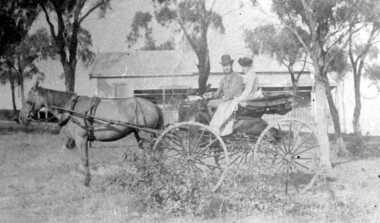
Photograph, 'Hillsboro' or "Hillsborough' - 6a Thistle Street, Surrey Hills, pre-1890
The photo was found behind a mantelpiece in the house at 6A Thistle Street while it was being renovated. It is thought to be of the first owner, Mrs Rachel Sweetnam (nee Lewis) and her husband, Thomas Edward Sweetnam. They were married on 24 September 1884 at St John's Church, Camberwell. REF: THE ARGUS 4 Oct 1884 Thomas second eldest surviving son of Matthew Sweetnam married to Rachel (Ray) third eldest daughter of Captain T.D. Lewis, Culm Haven, Camberwell. Thomas was active in land sales and variously described as a land agent, real estate agent and auctioneer. The property - Hillsboro or Hillsborough - was originally a house on a farm of 10 acres owned by her. It became 6A Thistle Street. According to the Alan Holt property register Rachel Sweetnam owned the property prior to 1890 and a family tree on Ancestry.com has that it was owned by her in c1886. It is likely that it was an investment rather than a family residence. Thomas Sweetnam was President of the Boroondara Shire 1888/89 and a councillor from 1886-1891. During his time as Shire councillor in 1887 he was charged with assaulting Charles A. Chandler, a window blind manufacturer, in response to an ‘insulting note’ left at Sweetnam’s house. Sweetnam was fined two guineas and 31 shillings. Sweetnam was also President of the Camberwell Gun Club from around 1890 – 91. In 1893 he relocated to Ferntree Gully, where he contested for the municipality’s North Riding council seat. Multiple references can be found on Trove. Note that the gentleman in this photo does bear a resemblance to Thomas Sweetman, President of Boroondara Shire in 1888-1889 found in the City of Boroondara Library Service mayoral portrait collection. No known photo of Rachel Sweetnam. Other property owners or residents are: 1890 Selina Gaylor 1900 Stephen Pullen 1910 William Murray (draftsman) 1920 George C Hughes 1930 Arthur Leslie Austin (tram driver) 1980 Mrs Lillian Evelyn Austin Sold in 1983 for $87,000. The house is still extant (January 2025). Note that we also have material / photos regarding George Hughes and family.This photo is one of the earliest photos of residences of Surrey Hills.Black and white photo of a woman and man in a buggy behind which is a simple house with a verandah at one end, surrounded by eucalypt trees.hillsboro, house names, thistle street, horse-drawn vehicle, clothing and dress, hillsborough, rachel sweetnam, rachel lewis, thomas sweetnam, selina gaylor, stephen pullen, william murray, george hughes, arthur austin, lillian austin -
 Bacchus Marsh & District Historical Society
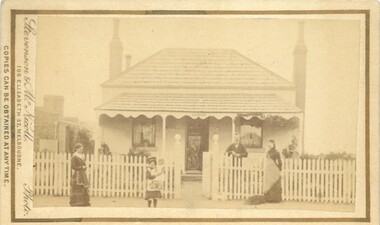
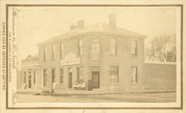
Photograph, White Cottage Young Street Bacchus Marsh 1883
This four roomed cottage with a detached kitchen was built for a Mr Elam, c. 1867. Occupants of this house among others have been Sir George Farmer, Christopher Crisp, Joseph Voysey, E. Simpson, J.R. Crook and H. Condon. It is located in Young Street and is opposite the site where the original Bacchus Marsh Mechanics Institute stood until about 1995.Small sepia unframed photograph on card with gold border framing photograph. Housed in the album, 'Photographs of Bacchus Marsh and District in 1883 by Stevenson and McNicoll'. The photograph is of a neat Georgian-style, double-fronted cottage. The hip roof and verandah are roofed with wooden shingles. Two tall chimneys stand, one at either side of the cottage, while a smaller chimney can be seen at the rear. The front verandah is decorated with carved barge boards. A white picket fence runs along the front, the entry posts featuring a carved globe-shaped finial. Standing inside the front fence is a smartly dressed gentleman, leaning on the fence. This is possibly Mr Joseph Voysey, Head Master of Bacchus Marsh Primary School 1879-1888, who purchased this cottage in 1882, the year before this photo was taken. Two women, one with a dog at her feet, stand on the footpath with a young girl holding a doll. This cottage still stands in Young Street, Bacchus Marsh.On the front: Stevenson & McNicoll. Photo. 108 Elizabeth St. Melbourne. COPIES CAN BE OBTAINED AT ANY TIME. On the back: LIGHT & TRUTH inscribed on a banner surmounted by a representation of the rising sun. Copies of this Portrait can be had at any time by sending the Name and Post Office Money Order or Stamps for the amount of order to STEVENSON & McNICOLL LATE BENSON & STEVENSON, Photographers. 108 Elizabeth Street, MELBOURNE houses bacchus marsh, stevenson and mcnicoll 1883 photographs of bacchus marsh and district -
 Warrnambool and District Historical Society Inc.
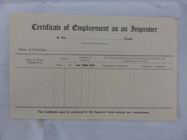
Document, Swintons certificate of Employment as an Improver, Mid 20th C
This certificate would have been used in the Warrnambool business of Swintons Pty Ltd. in the 20th century. It is a certificate that, when filled in, would have been given to anyone who had worked for some time as an unapprenticed tradesman’s assistant. William and Ann Swinton migrated to Australia in 1854 and for a decade William Swinton worked as a builder and carpenter in the Warrnambool district, erecting many buildings, including the Wangoom Presbyterian Church. In 1865 he opened a store in Timor Street, Warrnambool, selling groceries, china, glassware and hardware. By 1888 the business was known as William Swinton and Sons. Branch stores were opened in Wangoom, Cudgee, Nullawarre, South Warrnambool and West Warrnambool. After William Swinton’s death his son Robert became the first managing director of Swintons Pty Ltd. In 1934 the business split, with George Swinton and Sons selling clothing, furnishings and glassware and Swintons Pty Ltd selling hardware, seeds and produce. Today the Swinton family still operates a furniture and bedding store in Timor Street. This certificate is of minor interest as an example of a form used by businesses such as Swintons Pty Ltd to give to employees leaving the business. The current Swinton business in Timor Street, Warrnambool is the oldest family business in Warrnambool and, with the name Swinton associated with Timor Street businesses for 152 years, it is amongst the oldest family businesses in Australia.This is a sheet of buff-coloured paper with printed black lines and printed headings. The sheet is unused and slightly bent. ‘Certificate of Employment as an Improver’ swinton, history of warrnambool, warrnambool -
 Warrnambool and District Historical Society Inc.
Book, Swintons Stock book 1869, 1860s
This ledger is a Warrnambool Swintons Store stock book and contains the sales of stock from September 1869 to an unknown date (perhaps to the end of 1870) and entries for 1871, 1872 and 1873, 1889, the 1890s and some dates early in the 20th century. William and Ann Swinton migrated to Australia in 1854 and for a decade William Swinton worked as a builder and carpenter in the Warrnambool area, erecting many buildings, including the Wangoom Presbyterian Church. In 1865 he opened a store in Timor Street, Warrnambool selling groceries, glassware and china. In 1888 the business was known as William Swinton and Sons. Branch shops were opened in Cudgee, Nullawarre, Wangoom, South Warrnambool and West Warrnambool. When William died his son Robert became the first managing director of Swintons Pty Ltd. In 1934 the business split in two with George Swinton and Sons selling furnishings, clothing and glassware and Swintons Pty Ltd selling seeds, hardware and produce. Today the Swinton family still operates a furniture and bedding store in Timor Street. This ledger is very important as an early memento of the Swinton Stores in Warrnambool. It gives details of sales in the 19th century and has material relating to the assets of the founder of the business, William Swinton at the time of his death. It is of great interest to researchers. The current family business in Timor Street Warrnambool is the oldest family business in Warrnambool and, with the Swinton name associated with businesses in Timor Street for 152 years, is among the oldest family businesses in Australia. This is a dark green hard cover ledger with light brown leather bindings on the spine and cover edges. There is gold lettering on the spine. The cover is stained and the leather is torn and partly detached in places. The insides of the cover have a blue and white mottled patterning. The pages are blue with printed red lines. The entries are handwritten in black ink. There are four loose pages and two pieces of a plant dried and preserved between two pages. ‘Day Book’ ‘Stock Book Warrnambool September 2nd 1869’ swinton family, warrnambool -
 Warrnambool and District Historical Society Inc.
Ledger, Swintons, 1930s
This folder contains cards listing suppliers for the Warrnambool business, Swintons Pty Ltd. The cards date from the 1930s to the 1980s and contain information on the suppliers for seeds and farm requirements such as poultry pellets, calf food and stock salt. William and Ann Swinton migrated to Australia in 1854 and for a decade William Swinton worked as a builder and carpenter in the Warrnambool area, erecting many buildings, including the Wangoom Presbyterian Church. In 1865 he opened a shop in Timor Street, Warrnambool selling groceries, china, glass and hardware. By 1888 the business was known as William Swinton and Sons. Branch stores were opened in Cudgee, Nullawarre, Wangoom, South Warrnambool and West Warrnambool. After William died his son Robert became the first managing director of Swintons Pty Ltd. In 1934 the business split, with George Swinton and Sons selling furnishings, clothing and glassware and Swintons Pty Ltd selling seeds, hardware and produce. Today the Swinton family still operates a furniture and bedding store in Timor Street. This ledger is of interest as one from the Swinton business in Warrnambool. It gives us an idea of the items sold by Swintons Pty Ltd over a fifty-year period in the 20th century and will be very useful to researchers. The current Swinton business in Timor Street is the oldest family business in Warrnambool and, with the Swinton name associated with businesses in Timor Street, Warrnambool for 152 years, it is among the oldest family businesses in Australia. This is a black Kalamazoo folder made of thick board covered with material (leather?). The material is worn at the edges. The folder has a metal insert affixed with metal studs. The insert has thin metal wires strung across the inside. To these are affixed at the top with metal clips heavy-duty paper cards. There are two green cards with printed black material, one white card with printed blue material and the rest of the cards are yellow. The yellow cards are placed one under the other in a fan design. The yellow cards have printed red lines and printed titles and contain handwritten material, mostly in black ink. The cards, especially the green ones, are stained. ‘Kalamazoo-Acme Visible Card Books’swinton family warrnambool, history of warrnambool -
 Warrnambool and District Historical Society Inc.
Ledger, Swintons Ledger, 1960s
This ledger was used in the Warrnambool business of Swintons Pty Ltd. It contains the records of financial statements for the years 1969 to 1978 – rates and taxes accounts, trial balances and accounts for light and power, wages etc. William and Ann Swinton migrated to Australia in 1854 and for a decade William Swinton worked as a builder and carpenter in the Warrnambool area, erecting many buildings including the Wangoom Presbyterian Church. In 1865 he opened a store in Timor Street Warrnambool, selling groceries, china and glass ware and hardware. By 1888 the business was known as William Swinton and Sons. Branch stores were opened in Cudgee, Nullawarre, Wangoom, South Warrnambool and West Warrnambool. After William Swinton died his son Robert became the first managing director of Swintons Pty Ltd. In 1934 the business split with George Swinton and Sons selling furnishings, clothing and glassware and Swintons Pty Ltd selling seeds, produce and hardware. Today the Swinton family still operates a furniture and bedding store in Timor Street. This ledger is of considerable interest as it contains much important information on the financial operations of Swintons Pty Ltd in the 1960s and 70s. This information will be very useful to researchers. The current Swinton business in Timor Street is the oldest family business in Warrnambool and, with the name Swinton associated with Timor Street businesses for 152 years, it is among the oldest family businesses in Australia. This is a hard cover book with a green cover and a green mottled patterning inside the cover. The pages are held in the cover by two metal studs. There are white and yellow pages which have A to Z tabs on the side. The pages have printed blue lines. The entries are handwritten in blue ink with some pencil entries.swinton family, warrnambool, history of warrnambool -
 Warrnambool and District Historical Society Inc.
Leaflet, Kaye & Son, Printers, Swintons, Mid 20th century
This leaflet was a promotion tool of the Warrnambool business, Swintons Pty Ltd. It was used to insert stamps given by the firm when goods were purchased. When the pages were filled with 200 stamps the owner was given two shillings and sixpence in cash. It was a reward to the regular customer. William and Ann Swinton migrated to Australia in 1854 and for a decade William Swinton worked as a builder and carpenter in the Warrnambool area. In 1865 he opened a store in Timor Street, Warrnambool selling groceries, hardware, glassware and china. By 1888 the business was known as William Swinton and Sons. Branch stores were opened in Cudgee, Nullawarre, Wangoom, West Warrnambool and South Warrnambool. After William Swinton’s death, his son, Robert, became the first managing director of Swintons Pty Ltd. In 1934 the business split, with George Swinton and Sons selling furnishings, clothing and glassware and Swintons Pty Ltd selling groceries, seeds, produce and hardware. Today the Swinton family still operates a furniture and bedding store in Timor Street. This leaflet is of interest as an example of the advertising practices carried out by the firm of Swintons Pty Ltd, an important business in Warrnambool for many years. The current Swinton business in Timor Street, Warrnambool is the oldest family business in Warrnambool and, with the name Swinton associated with Timor Street businesses for 152years, it is amongst the oldest family businesses in Australia.This is a leaflet with a grey cover and four pages inside. The cover has dark blue printing and the pages have black printing and are ruled into 15 spaces. There are over 100 blue stamps stuck onto the ruled spaces. The cover is tattered at the edges and one stamp is loose.‘Swintons Pty Ltd Timor Street Warrnambool Provision, Seed and Hardware Merchants Blue Cash Coupons Bank Book’ swinton family businesses, warrnambool, history of warrnambool -
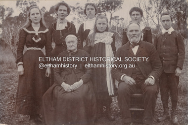 Eltham District Historical Society Inc
Photograph, Nicholes Photorgraphers, Phillip Shillinglaw with his mother and children, c.1905
Standing: Florence May Shillinglaw (1886-1969), Elizabeth (Lizzie) Ann Shillinglaw (1879-1972), Mary Ann Shillinglaw (1880-1963), Ada Maria Shillinglaw (1889-1974), Caroline (Carrie) Shillinglaw (1876-1956), Ernest Samuel Shillinglaw (1888-1958) Seated: Jean Shillinglaw (nee Blemner 1819-1906), Phillip Shillinglaw (1842-1914) Nicholes Photographer, Alphington According to the Sands McDougall Melbourne Directory, George. Nicholes, Photographer was first listed on the north side of Heidelberg Road, Alphington in 1904 and again in 1905. By 1906 he was still listed but with no profession. From 1907 on he was listed as a bicycle agent. PANEL 1875-1920 Panels began to be produced around 1875, and were particularly suited, because of their larger size, for capturing family, or even larger, groups. They measured 8.5 by 6.5 inches (22 cm x 16.5 cm). - Frost, Lenore; Dating Family Photos 1850-1920; Valiant Press Pty. Ltd., Berwick, Victoria 1991marg ball collection, 1905, 1904-1905, ada maria chrisfield (nee shillinglaw) 1889-1974, ada maria shillinglaw (1889-1974), caroline (carrie) watson (nee shillinglaw) 1876-1956, elizabeth (lizzie) ann shillinglaw (1879-1972), ernest samuel shillinglaw (1888-1958), florence may bunker (nee shillinglaw) (1886-1969), jean shillinglaw (nee blemner 1819-1906), mary ann shillinglaw (1880-1963), nicholes photographer alphington, phillip shillinglaw (1842-1914) -
Glen Eira Historical Society
Article - Sargood Family
This file contains six articles on the Sargood family. Two photocopied pages from BURKE’S COLONIAL GENTRY vol. 1, 1891, on the Frederick Thomas Sargood family lineage, pages 129 and 130. Article on Frederick Thomas Sargood on education, business ventures, the volunteer forces, and his ministerial position and marital status, taken from VICTORIA AND ITS METROPOLIS vol. 2, 1888, page 501. Nine handwritten pages of Frederick James Sargood family tree, primarily taken from Sargood Family Bible, Melbourne University archives, undated. One typed and one carbon copy of written notes on Sargood family in Australia up to family member Edith Marian. Hand written notes taken from Caulfield Rate Books 1858 to 1892, on Frederick Thomas Sargood, also St Kilda rate books 1867 to 1874. Hand written details of unknown relationships to F. G. Sargood and listing of Sargoods from phone book, date unknown.sargood frederick thomas, sargood marian australia rolfe, sargood frederick george, sargood percy rolfe, sargood alfred herbert, sargood harry morton, sargood willie ernest, sargood clara wordsworth, sargood edith marian, sargood emma winnifred, sargood gulielma bertha, sargood charlotte rippon tomlin, sargood julia charlotte, sargood frederick james, warehouses, defence forces, parliamentary representatives, st mary’s church, allen william, hotham street, caulfield, glen eira road, sandham street, ripponlea, housenames, mansions, willow street, gardeners, coachmen, à beckett t. t., alma road -
 Federation University Historical Collection
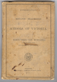
Book, Ferdinand von Mueller, Introduction to Botanic Teachings at the Schools of Victoria, 1877, 1877 (exact)
Ferdinand von Mueller was an examiner of botany at the Ballarat School of Mines (SMB) between 1880 and 1888. During that era he was active in donating related items to the School. When the Ballarat School of Mines Council agreed to introduce pharmacy and botany classes in 1879, it was apparent students would require access to botanical specimens in order to further their studies. Council members, who were inspired by the work of Baron Ferdinand von Mueller, authorised development of an area along the School's northern boundary, fronting Lydiard Street South, and oversaw the establishment of the new Botanical Gardens. Baron von Mueller took a practical role the development of SMB's Botanical Gardens from the beginning. He became a generous benefactor who 'donated collections of seeds and leguminous fodder plants, including valued grasses of interest and use to agriculturalists and graziers generally' to SMB over many years. Ferdinand von Mueller's entry on the University of Ballarat Honour Roll can be found at http://www.ballarat.edu.au/curator/honour-roll/honourroll_von_mueller.shtml A light brown, hardcovered book of 152 pages. Chapters include Eucalyptus Trees; Wattles or Acacias; Casuarinas or Sheoaks; Cypress Pines or Sandarac trees; Exocarpos trees of Natice Cherry trees; Mistletoes; Native Honeysuckles or Banksias; Bellflower, Lobelia and Goodenia; Heaths; Correas; Mallow; Buttercups and Clematis; Cruciferous Plants; Mints; Orchids; grasses; ferns. The book has numerous botanical line drawings, and a comprehensive index.Inside front cover "J. Clement Souter M.D."victorian, schools, botany, ferdinand von mueller, von mueller, botanic illustrations, j. clement souter -
 Federation University Historical Collection
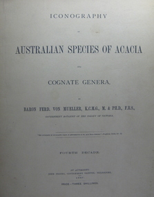
Book, Baron Ferdinand Von Mueller, Australian Species of Acacia and Cognate Genera
Ferdinand von Mueller was an examiner of botany at the Ballarat School of Mines (SMB) between 1880 and 1888. During that era he was active in donating related items to the School. When the Ballarat School of Mines Council agreed to introduce pharmacy and botany classes in 1879, it was apparent students would require access to botanical specimens in order to further their studies. Council members, who were inspired by the work of Baron Ferdinand von Mueller, authorised development of an area along the School's northern boundary, fronting Lydiard Street South, and oversaw the establishment of the new Botanical Gardens. Baron von Mueller took a practical role the development of SMB's Botanical Gardens from the beginning. He became a generous benefactor who 'donated collections of seeds and leguminous fodder plants, including valued grasses of interest and use to agriculturalists and graziers generally' to SMB over many years. Ferdinand von Mueller's entry on the University of Ballarat Honour Roll can be found at http://www.ballarat.edu.au/curator/honour-roll/honourroll_von_mueller.shtml Large format, brown, soft covered books with beautiful line drawings. Set contains 6 of 13 parts, Part 1 covers the fourth decade, Part 2 the fifth decade, Part 3 the eight decade, Part 4 the ninth decade, Part 5 the tenth decade and Part 6 the eleventh decade.botany, ferdinand von mueller, von mueller, botanic illustrations, government botanist, acacia -
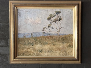 Robin Boyd Foundation
Painting, Arthur Boyd, Wheat Fields Behind Rosebud, 1938
In 1938, Robin Boyd's grandfather Arthur Merric Boyd offered Robin his first commission, a studio for Robin's first cousin Arthur Boyd on the family property at Murrumbeena. This painting by Arthur Boyd was part of Ralph Madder’s estate and inherited by his daughter, Patricia, Robin Boyd's wife. Ralph Madder (1892 - 1986) was Arthur Boyd’s uncle and employed the young Arthur in his calcimine paint factory and bought the occasional painting to help the young artist. This painting dates from a later time when Arthur was living with, and looking after, his aged grandfather Arthur Merric at Rosebud (see the book “The Boyds” by Brenda Niall pages 188-9). “Wheat fields behind Rosebud” did not come to 290 Walsh Street until after Ralph Madder’s death in 1986. Note: Robin Boyd's uncle Merric Boyd (1888-1959) married Patricia’s aunt Doris Gough. This means that Arthur Boyd was a first cousin to both Robin Boyd and Patricia Madder. Landscape in gold wooden frameA.M.B Boyd 1938 on lower right hand sidearthur boyd, arthur merric boyd, robin boyd, walsh st artwork, ohm2022, ohm2022_1 -
 Bendigo Historical Society Inc.
Slide - Osborne House 33 MacKenzie Street Bendigo
The Bendigo & Region Branch is the National Trust’s voice in the region. The Branch works with council and the community on local heritage issues. New members are always welcome at any of the Branch’s meetings and events. Designed by renown Bendigo architects Vahland and Getzschmann, Osborne House was originally built as a private school in 1869, extended in 1870 and sold in 1888 when it became a boarding house. The property enjoys a privileged position surrounded by more of Vahland's inspiring designs - the Forest Street Anglican, Methodist and Congregational churches while just over the hill, the massive spire of the Sacred Heart Cathedral dominates the skyline. Both the skyline and the residence have undergone much change over the last century and now enjoy a harmonious blend of traditional form and modern function. Beyond the secluded front entry, Osborne House offers grand Victorian proportions blended seamlessly with a timeless French influence. Built over three levels, the residence has four bedrooms plus home office, grand formal lounge and dining roomsOsborne House 33 MacKenzie Street Bendigo - Slidehistory, bendigo, national trust collection bendigo, osborne house 33 mackenzie street bendigo -
 Kew Historical Society Inc
Plan - Subdivision Plan, J R Mathers & McMillan, Plan of Subdivision of Part of Crown Portion 83 at Kew : LP6669, 1923-1939
In 1888, in the section of Park Hill Road between Belmont Avenue and Normanby Road there was only one street running between Park Hill Road and Cotham Road. This was Park Road, later to be named Adeney Avenue. Subsequent 20th century subdivisions created the ‘through roads’ of Cecil Street, Wimba Avenue, Florence Avenue, Marshall Avenue, Uvadale Road, and Barrington Avenue. This subdivision represents an attempt by auctioneers, rather than town planners to create an urban environment from larger residential allotments or in many cases farmland. Existing streets such as Parkhill and Normanby Roads provided a convenient starting point for the surveyors, but the Road named ‘Street Street’ indicates the role of the private surveyor in creating streets. Given that a number of allotments are listed as sold on the plan, the street is presumably Cecil Street. Even those lots that had been sold do not quite match the dimensions of the blocks in this parcel of land today, indicating that either further subdivisions or boundary alterations occurred.Subdivision plans are historically important documents used as evidence for the growth of suburbs in Australia. They frequently provide information about when the land was sold as well as evidence relating to surveyors and real estate and financial agents. The numerous subdivision plans in the Kew Historical Society's collection represent working documents, ranging from the initial sketches made in planning a subdivision to printed plans on which auctioneers or agents listed the prices for which individual lots were sold. In a number of cases, the reverse of a subdivision plan in the collection includes a photograph of a house that was also for sale by the agent. These photographs provide significant heritage information relating house design and decoration, fencing and household gardens.The photograph may also be aesthetically significant depending on the importance of the photographic atelier.Hand-drawn subdivision plan of 19 lots facing Parkhill Road, Normanby Road, and an unnamed street [now Cecil Street] in Kew.Estate Agent notes in ink indicate those lots which had sold.subdivision plans - kew, parkhill road - kew, cecil street - kew, normanby road - kew, cecil street -kew, parkhill road - kew, normanby road - kew, crown portion 83 - kew -
 Kew Historical Society Inc
Photograph - Civic event in Stradbroke Park, 1976
Stradbroke Park. Extent: Kilby Road to Harp Road at Burke Road. Historical Documentation: 1851 - Portion 91 purchased by Edward Glynn; 1888 - The Harp of Erin Estate (which included Section 91) offered for sale; 1896 - The area now known as Stradbroke Park was bisected by a creek that flowed from the Yarra via Hay's Paddock (q.v.) and extended through to Burke Road; 1943 - W.D. Birrell, Town Clerk of Kew, proposed that the creek be filled and a reserve created; 1954 - Entire area designated as 'open space' and named 'Stradbroke Park'. The line of the creek that ran through the Park created a further reserve on the north side of High Street, now known as 'Harrison Reserve'. Existing Condition: The park is largely of mown grass that has mature trees set into it It is possible that a number of these are remnant of the original vegetation, while there are also a number of exotic trees introduced, particularly at the northern end of the park. The southern end is dominated by playing fields. (Source: Sanderson, P 1988. Kew Conservation Study)Colour photographic positive (with colour degradation) of sporting teams at a civic event in Stradbroke Park in Kew East in May 1976. The event was officiated by the Mayor of Kew, Cr Alan Hutchinson. Sporting teams in uniform included: footballers, athletes, cricketers, hockey players. Stradbroke Park is situated on the western boundary of Kew at Burke and Harp Roads.stradbroke park, cr alan hutchinson, team sports -- kew (vic.) -
 Kew Historical Society Inc
Photograph - Civic event in Stradbroke Park, 1976
Stradbroke Park. Extent: Kilby Road to Harp Road at Burke Road. Historical Documentation: 1851 - Portion 91 purchased by Edward Glynn; 1888 - The Harp of Erin Estate (which included Section 91) offered for sale; 1896 - The area now known as Stradbroke Park was bisected by a creek that flowed from the Yarra via Hay's Paddock (q.v.) and extended through to Burke Road; 1943 - W.D. Birrell, Town Clerk of Kew, proposed that the creek be filled and a reserve created; 1954 - Entire area designated as 'open space' and named 'Stradbroke Park'. The line of the creek that ran through the Park created a further reserve on the north side of High Street, now known as 'Harrison Reserve'. Existing Condition: The park is largely of mown grass that has mature trees set into it It is possible that a number of these are remnant of the original vegetation, while there are also a number of exotic trees introduced, particularly at the northern end of the park. The southern end is dominated by playing fields. (Source: Sanderson, P 1988. Kew Conservation Study)Colour photographic positive (with colour degradation) of sporting teams at a civic event in Stradbroke Park in Kew East in May 1976. The event was officiated by the Mayor of Kew, Cr Alan Hutchinson. Stradbroke Park is situated on the western boundary of Kew and bordered by Burke and Harp Roads.stradbroke park, cr alan hutchinson, team sports -- kew (vic.) -
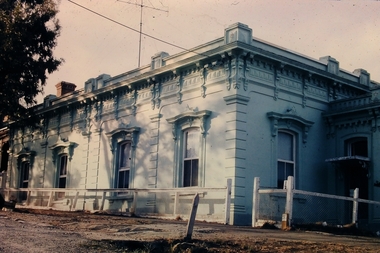
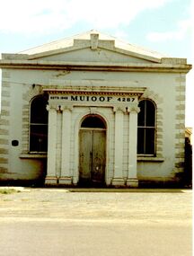 Port Fairy Historical Society Museum and Archives
Photograph
This building is the second of the Manchester Unity Independent Order of Oddfellows rooms the first built in 1862 and opened in that year on the fifteenth anniversary of the foundation of the Lodge in Belfast/Port Fairy. In 1872 a 35foot addition was added to the back and in 1873 the grand porch was added. The hall was destroyed by fire in 1875 and the only item saved was the cedar Dispensation frame of the past Grand Masters made by John Gallin that now resides in the Historical Society Rooms. The Trustees bought another building which occupied the land now occupied by the National Australia Bank on the corner of Sackville and Cox Streets but it was not suitable so they decided to re-instate the building whose ruins in the meantime had been used by Cobb and Co. This new building was designed by Charles Neylon an architect and built by Robert Ireland. The completed building was re-opened in December 1888 with four front rooms, a mezzanine floor and a hall measuring 32' by 26' and capable of holding 200. The Trustees of the Loyal Prince Albert Lodge sold the building in 1978 and is now a private home.Coloured photograph of Imposing M.U.i.O.O.F. Society building with a faux columned portico, double door entry two large windows either sideinstitution, loyal prince albert lodge, m.u.i.o.o.f., manchester unity independent order of oddfellows, society, muioof hall pt fairy -
 Wodonga & District Historical Society Inc
Book - Hamilton-Smith Collection Bible c. 1800s - 1900s, Eyre and Spottiswoode, LTD
The Hamilton-Smith collection was donated by the children of Grace Mary Hamilton-Smith nee Ellwood (1911-2004) and John Hamilton-Smith (1909-1984) who settled in Wodonga in the 1940s. The Ellwood family had lived in north-east Victoria since the late 1800s. Grace’s mother, Rosina Ellwood nee Smale, was the first teacher at Baranduda in 1888, and a foundation member of the C.W.A. Rosina and her husband Mark retired to Wodonga in 1934. Grace and John married at St. David’s Church, Albury in 1941. John was a grazier, and actively involved in Agricultural Societies. The collection contains significant items which reflect the local history of Wodonga, including handmade needlework, books, photographs, a wedding dress, maps, and material relating to the world wars. This Christian bible belonged to Grace Hamilton-Smith (nee Ellwood). The inscriptions indicate it was owned and used while she was at boarding school in Melbourne in the 1930s. It was published by the London printer Eyre and Spottiswood, established in 1739.This item has well documented provenance and a known owner. It forms part of a significant and representative historical collection which reflects the local history of Wodonga. It contributes to our understanding of social and family life in early twentieth century Wodonga, as well as providing interpretative capacity for themes including local history and social history.A black cloth bound Christian bible containing old and new testaments. On inner front page proper left upper corner in pencil: "Grace W Ellwood/"Braeside"/Bethonga./Victoria/Grace Ellwood/Morris Hall/Sth Yarra". On inner front paper proper left lower corner in pencil: "Grace Ellwood/Morris Hall/M.L.L. GLS/1925-6-7".bible, religion, christianity, hamilton-smith, ellwood, wodonga, school, jesus -
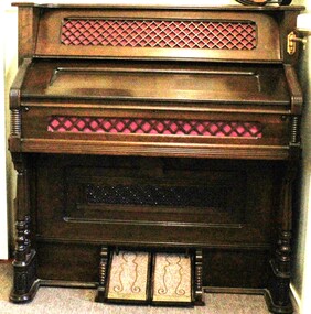 Wodonga & District Historical Society Inc
Instrument - Farrand & Votey Pump Organ, Farrand & Votey Organ Company, c1885
This Farrand & Votey pump organ was manufactured in Detroit USA c1885. It was lovingly restored by the late Peter Frost of Tallangatta. The organ was gifted to Peter in 2000 in a state of disrepair and was not working. Peter was born in Devon, England in 1930 and completed an apprenticeship in joinery and cabinetry, specialising in ornate church and cathedral furniture. He migrated to Australia in 1957 and became a highly regarded woodwork and building science teacher as well as a Building Inspector. He was also a passionate musician. On completion of the refurbishment Peter gave the organ to his daughter at Georges Creek. Farrand & Votey started out as the Detroit Organ Co. in 1881. They started building pipe organs in 1888. Votey did pioneering work on piano players, developing the famous Pianola. However, in 1897 the company split up, Farrand remaining with the reed organs as the Farrand Organ Co., and Votey taking the pipe organ and player piano business. The Farrand Organ Co. later brought out its own piano player, the Cecilian, but went bankrupt in 1915.This organ is an example of a craftsmanship from the late 19th century and has been fully refurbished by a skilled craftsmen from the Tallangatta district near Wodonga.An upright Farrand & Votey Pump Organ which was originally manufactured in Detroit, USA. It has been fully refurbished and is in working condition. Ron Fudge, a pump organ restorer in USA has dated it at c.1885 based on its serial number 14404 83.Above keyboard: "Farrand & Votey"farrand & votey, pump organ, organ restoration -
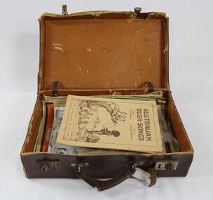 Wodonga & District Historical Society Inc
Booklet - Hamilton-Smith Collection Suitcase with Booklets and other Publications c. early to mid 1900s
The Hamilton-Smith collection was donated by the children of Grace Mary Hamilton-Smith nee Ellwood (1911-2004) and John Hamilton-Smith (1909-1984) who settled in Wodonga in the 1940s. The Ellwood family had lived in north-east Victoria since the late 1800s. Grace’s mother, Rosina Ellwood nee Smale, was the first teacher at Baranduda in 1888, and a foundation member of the C.W.A. Rosina and her husband Mark retired to Wodonga in 1934. Grace and John married at St. David’s Church, Albury in 1941. John was a grazier, and actively involved in Agricultural Societies. The collection contains significant items which reflect the local history of Wodonga, including handmade needlework, books, photographs, a wedding dress, maps, and material relating to the world wars. The ephemeral edition of 'Australian Bush Songs' visible inside the case was published in 1937 in Melbourne by Allan & Co. It contains children's songs drawing on Australian themes which were popular and well-known in the 1930s. This item has well documented provenance and a known owner. It forms part of a significant and representative historical collection which reflects the local history of Wodonga. It contributes to our understanding of social and family life in early twentieth century Wodonga, as well as providing interpretative capacity for themes including local history and social history.A brown vinyl suitcase containing song books, periodicals and magazines c. 1920s - 1930s.hamilton-smith, ellwood, hamilton-smith collection, wodgona, books, reading, songs, song, singing, children, child -
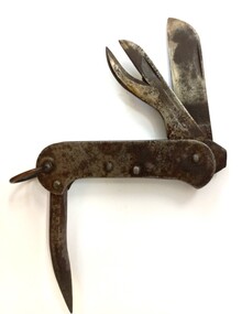 Wodonga & District Historical Society Inc
Functional object - Australian Army Issue Clasp Knife
Australian manufactured clasp knives were a standard issue to Australian Military Forces during World War 2. The most commonly encountered knife was an all metal model with a canoe shaped body. This knife was a Whittingslowe first pattern clasp knife which included a blade, a tin opener and a marline spike as well as screw driver and shackle to attach the knife to a lanyard or belt clip. These knives were given a dull Nickel plating to protect them. William Thomas Whittingslowe was born in Wales in 1888, he was educated in England and at 18 migrated to Canada and then to Australia, arriving in about 1912. After working in various states, he settled in South Australia and in the 1920s set up his own business, Whittingslowe Engineers Limited. He specialised in ironworking and knife manufacturing. His firm produced a large amount of blade ware during World War 2. He also designed and built manufacturing equipment for General Motors Holden. He died at Murray Bridge (SA) in 1956.This item is significance because it was donated by a member of the community of Wodonga which has a strong connection to Australian military history.A clasp knife made completely from metal with nickel plating. The accessories all fold into a canoe-shaped body. It included a knife, can opener and marlin spike.On knife blade: WE over a broad arrow/I\australian army equipment ww2, thomas whittingslowe, australian army -
 Bacchus Marsh & District Historical Society
Photograph, Royal Hotel corner of Main and Young Streets Bacchus Marsh 1883
This image is one of a series of photographs taken by Melbourne based photographers Stevenson and McNicoll who visited Bacchus Marsh nearby districts between September and November 1883. The Royal Hotel was built in 1861 and is located on the corner of Main and Young Streets in Bacchus Marsh. The first owner was James Murray and the hotel was first known as the Murray Family Hotel. James Murray died in an accident in 1863 and sometime after this the ownership passed to Richard Manning. From around 1869 it became known as the Royal Hotel. Richard Manning's son Frederick Manning inherited the hotel in 1896. The Manning family owned the hotel until sometime after 1945. In more recent decades it has been owned and operated by a number of different people. The hotel continues to operate as of 2024. This image shows the building in its original structure. In 1888, five years after this image was taken, a second storey was added to the section on Young Street. In this image this section is the single storey section of wall without windows to the right of the picture. Small sepia 'carte de viste' style unframed photograph on card with gold border framing photograph. Housed in the album, 'Photographs of Bacchus Marsh and District in 1883 by Stevenson and McNicoll'. The image shows the Royal Hotel seen from the intersection of Main and Young Streets. The diagonal view shows both the Main Street and Young Street sides of the building. It is a two storey brick building with a single storey brick extension on the Young Street frontage. Standing at the corner of the building is a woman and five girls. A deep gutter runs along the Main Street, with a pedestrian crossing ramp. Over this crossing point, there is a large metal frame bearing an ornate lantern. Next to it is a water trough for horses. Several hitching posts can be seen along the footpaths.Printed On the front: Stevenson & McNicoll. Photo. 108 Elizabeth St. Melbourne. COPIES CAN BE OBTAINED AT ANY TIME. On the back: LIGHT & TRUTH inscribed on a banner surmounted by a representation of the rising sun. Copies of this Portrait can be had at any time by sending the Name and Post Office Money Order or Stamps for the amount of order to STEVENSON & McNICOLL LATE BENSON & STEVENSON, Photographers. 108 Elizabeth Street, MELBOURNE. stevenson and mcnicoll 1883 photographs of bacchus marsh and district, hotels bacchus marsh, royal hotel bacchus marsh, manning family bacchus marsh, murray family hotel bacchus marsh -
 Geoffrey Kaye Museum of Anaesthetic History
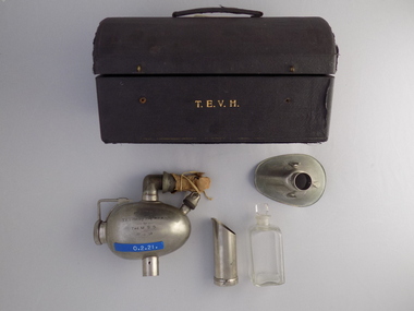
Equipment - Inhaler, Probyn Williams, Mayer & Meltzer, c. 1900
Hurley, Sir Thomas Ernest Victor (1888-1958) was gifted this Probyn Williams inhaler in 1914. After studying at Melbourne University, Victorian-born Hurley was a Medical Officer at the Royal Melbourne Hospital until he commenced private practice in Collins Street. He was appointed Captain Australian Army Medical Corps, AIF and served in Gallipoli with the 2nd Field Ambulance. He served in Enypt, London, and the Western Front during World War 1. He gained a Companion of the Order of St George and St Michael in 1917. Upon return to Melbourne he held positions such as surgeon to Victoria Police (1928-1956), elected to Council of the Victorian branch of the British Medical Association, member of the Charities Board of Victoria and foundation member of the Royal Australasian College of Surgeons and chaired the Flying Personnel Research Committee m a consulting surgeon at the Royal Melbourne Hospital. This apparatus is transitional between Clover's and Hewitt's having Clover's narrow "ways" and compact size, but using Hewitt's ether-control lever.Black round topped box with brass hooks [missing] at front and brass hinges at rear. The initials T.E.V.H. are printed in gold leaf on the front. There is a black fabric handle on the top. Inside the box is black padding with the manufacturer's logo printed in gold leaf. There is a square section in the base of the box for holding the square clear glass bottle for ether. The pear-shaped mask is made of metal. There is also a metal ether measure for pouring the ether. The metal inhaler is ovoid shaped. The rotating gauge has a series of numbers engraved onto the inhaler for measurement. There is an elbow joint attaching a re-breather bag, with a small amount of waxy paper remaining attached with a thin ribbon. There is a small glass bulb encased in a metal housing. Printed in gold leaf on front of box: T.E.V.H. •Printed in gold leaf on inside lid of box: MAYER & MELTZER / LONDON / MELBOURNE & CAPE TOWN •Engraved on side of inhaler: PRESENTED / TO / T.E.V. Hurley Esq.,M.D.M.S. / by / THE M.S.S. / 15.6.14. •Engraved on reverse side of inhaler: PROBYN WILLIAMS / ETHER INHALER •Moulded into connector on elbow joint: MAYER & MELTZER •Stamped into base of metal pourer: MAYER & MELTZER / LONDON •Blue sticker with white printed text on front of inhaler: O.2.21.hurley, thomas ernest victor, probyn williams, university of melbourne, world war 1, wwi, gallipoli, australian army medical corps, medical student society, mayer & meltzer, clover, joseph, hewitt, fredrick william