Showing 17154 items
matching bay-bridge
-
 Eltham District Historical Society Inc
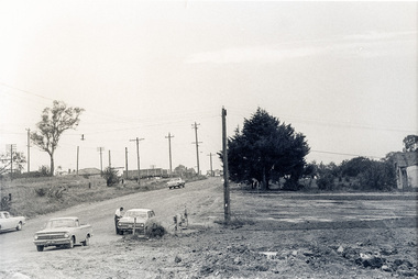
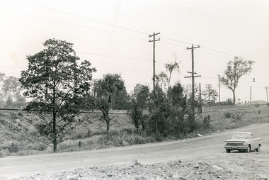
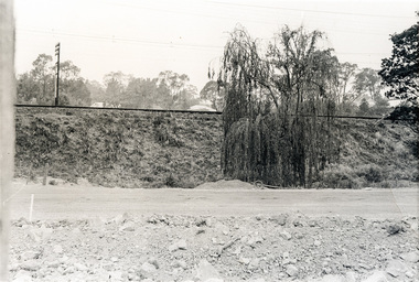
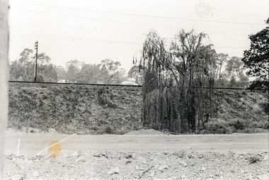
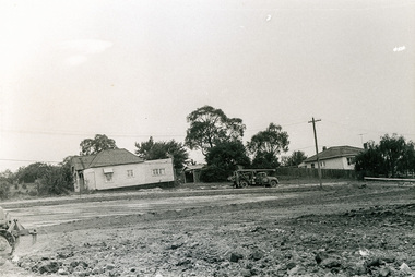
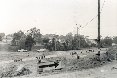
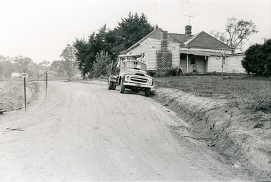
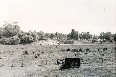
Photograph, Sherbourne Road, Para Road and Simms Road at Briar Hill/Montmorency prior to the upgrade of Sherbourne Road Railway bridge, c.1970
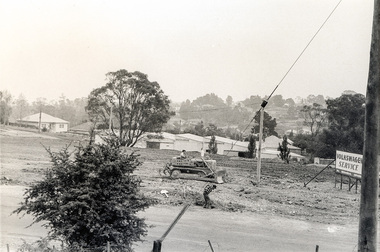
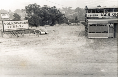
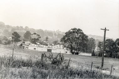
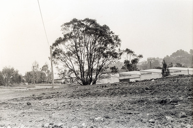
Collection of photographs probably taken around the same time depicting Sherbourne Road, Para Road and Simms Road at Briar Hill/Montmorency prior to the upgrade of Sherbourne Road Railway bridge, c.1970. Photo 01648_ 19 This home owned by Mrs Cameron. Her daughter married a Mr Davey, for whom Davey Road was named - email from M. Jones 20/07/2015 Photographer unknownThese photos are very significant in the documentation of the development of the Briar Hill and Montmorency areas and the changes in the physical landscape along the railway line area.20 black and white prints 9 cm x 13 cm.1970, briar hill, davey road, montmorency, para road, cameron, davey, sherbourne road, simms road, railway line, roadworks -
 Eltham District Historical Society Inc
Photograph, Sherbourne Road, Para Road and Simms Road at Briar Hill/Montmorency prior to the upgrade of Sherbourne Road Railway bridge, c.1970
Collection of photographs probably taken around the same time depicting Sherbourne Road, Para Road and Simms Road at Briar Hill/Montmorency prior to the upgrade of Sherbourne Road Railway bridge, c.1970. Photo 01648_ 19 This home owned by Mrs Cameron. Her daughter married a Mr Davey, for whom Davey Road was named - email from M. Jones 20/07/2015 Photographer unknownThese photos are very significant in the documentation of the development of the Briar Hill and Montmorency areas and the changes in the physical landscape along the railway line area.20 black and white prints 9 cm x 13 cm.1970, briar hill, davey road, montmorency, para road, cameron, davey, sherbourne road, simms road, railway line, roadworks -
 Eltham District Historical Society Inc
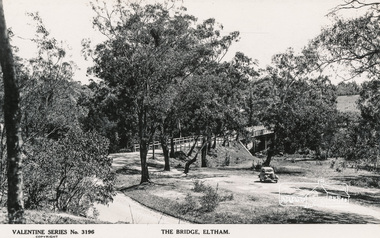
Postcard - Photograph, The Rose Stereograph Company, The Bridge, Eltham, c.1939
Looking west across the Main Road Bridge over the Diamond Creek at Eltham, c.1939. The car in the foreground, possibly the photographer's, is a Ford Model C Ten built by Ford UK between 1934 and 1937. The Model C was released in Australia in 1935. The Ford Model C Ten is a car that was built by Ford UK between 1934 and 1937. The Model C was released in Australia in 1935 https://en.wikipedia.org/wiki/Ford_Model_C_TenPostcardValentine Series No.3196diamond creek (creek), ford model c ten, main road bridge, postcard, valentine series postcard, bridge, cars, eltham, eltham south, main road, motor vehicles, rose stereograph, rose stereograph company -
 Eltham District Historical Society Inc
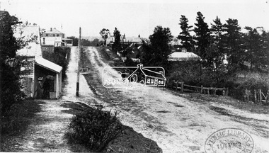
Photograph, View in Eltham looking south along Main road from Bridge Street, 1902
Looking south along Main Road from the south side of the intersection of Bridge Street with Main Road. Post Office (Anne Hunniford Postmistress) on left then the Commercial Bank of Australasia building. The house on the right, 'Derril,' was purchased by Walter Gahan in 1924 and was demolished in 1968 when Main Road was widened. In the distance on the left is Watson's Hotel and on the right (opposite side of the main road, Morris's Hotel Cross Ref: 0624This photo forms part of a collection of photographs gathered by the Shire of Eltham for their centenary project book,"Pioneers and Painters: 100 years of the Shire of Eltham" by Alan Marshall (1971). The collection of over 500 images is held in partnership between Eltham District Historical Society and Yarra Plenty Regional Library (Eltham Library) and is now formally known as the 'The Shire of Eltham Pioneers Photograph Collection.' It is significant in being the first community sourced collection representing the places and people of the Shire's first one hundred years.Digital image Print 14 x 24 cm 35 mm B&W negativeanne jane hunniford (1855-1928), bridge street, commercial bank of australia, derril, eltham, gahan house, main road, morris's hotel, post office, shire of eltham pioneers photograph collection, watsons hotel -
 Wangaratta Historical Society
Toll Gates, Wangaratta Toll Bridge, Mid 19th Century
Wangaratta Toll Gates were erected after the punt was sunk and the new bridge over the Ovens river was opened in 1855; a charge was made for people, animals, carts, cars and buses and trucks later on. A gatehouse keeper lived in a residence near the gates to charge users when they crossed. The gates were refurbished by the students at the local GOTAFE college and are being rehoused as a feature of the river beautification works along the Ovens River.The Toll Gates were on the first (and only bridge at the time) that crossed near the junction of the Ovens & King rivers at Wangaratta in the mid 1800's. They are a vital part of the city's heritage.Two white timber gates, hung on white timber posts by metal hinges. wangaratta toll gates -
 Phillip Island and District Historical Society Inc.
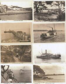
Photograph - Post Cards, Rose Series et al, Early 20th Century
One of 15 Sheets with copies of postcard printed on them. From the Shirley Jones Collection.Postcard copies: Bay View Guesthouse Cowes; Summerland Jetty; Lovers' Walk Cowes; The Estelle Star; Bay View Guesthouse Cowes; Genista Ferry; S.S.Killara; The Cowes Pier."Bay View Guest House Cowes" - "Summerland Jetty" - "The Lovers Walk Cowes Phillip Island Vic" - "The Estelle Star arriving at Pier Cowes" - "Bay View Guest House" - "Genista off from San Remo" - "Photo Shop Series S.S.Killara Cowes" - "The Pier Cowes Phillip Is Victoria".bayview guesthouse cowes, summerland jetty phillip island, lovers walk cowes, the estelle star, genista, ferry - genista, ss killara, cowes pier phillip island, shirley jones collection, thelma astbury -
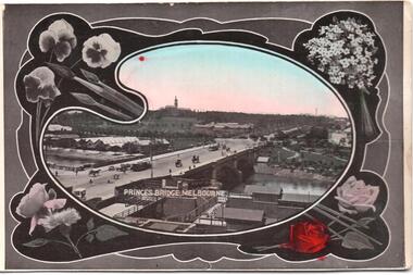 Melbourne Tram Museum
Postcard, SEMCO, "Princes Bridge Melbourne", mid 1900's?
Divided back postcard featuring a hand coloured black and white photograph of a view looking from Flinders St towards Government House, c1900, or from the roof of the Flinders St Station which could be under construction. Embossed Photograph enclosed within an artists palette, surrounded by roses. Note the buildings between the bridge and Government house - a former asylum? Card from the SEMCO Series Box 545 GPO Melbourne. Addressed to Miss V Hall of Blackwood.trams, tramways, princes bridge, cable trams, flinders st, flinders st station -
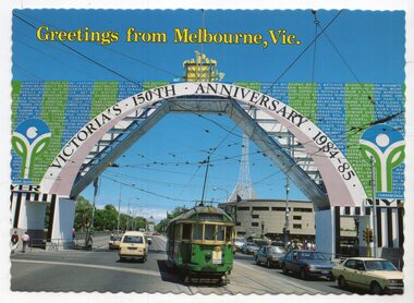 Melbourne Tram Museum
Postcard, Biscay Greetings, W2 601, passing under the 150th Victorian Anniversary arch on Princes Bridge, 1984/85
Colour postcard divided back, serrated edges - Biscay Greetings, series of featuring W2 601, passing under the 150th Victorian Anniversary arch on Princes Bridge during 1984 or 1985. Has the Arts Centre in the background. Tram has the destination of Glen Iris, Route 6. Back has space for name and address, stamp and a message and details of the postcard. Produced by Biscay Greetings, possibly mid to late 1980's. Card No. BG200. Two copies held.trams, tramways, princes bridge, 150th anniversary victoria, w2 class, ceremonies, route 6, tram 601 -
 Clunes Museum
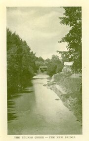
Photograph, AJAX SERIES - PRODUCED IN VICTORIA
PRODUCED IN VICTORIACOPY OF PHOTOGRAPH OF CLUNES CREEK - BLUESTONE "GOVERNMENT" BRIDGE IN THE BACKGROUND, SMALL HUT ON RIGHT HAND BANK OF CREEK.THE CLUNES CREEK - THE NEW BRIDGElocal history, document, postcard, bridges -
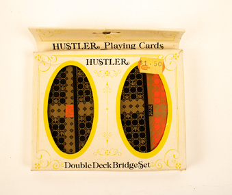 Stanley Athenaeum & Public Room
Leisure object - Euchre Cards - Hustler
Hustler brand. Double deck Bridge set. Plastic coated.Hustler/Double Deck Bridge set. Coles sticker. -
 Glenelg Shire Council Cultural Collection
Photograph - Photograph - Canal Bridge Construction, n.d
Port of Portland Authority ArchivesFront: Back- 'Clift Street Bridge' - top left, black biro Purple csiro stamp.port of portland archives -
 Eltham District Historical Society Inc
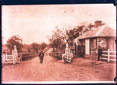
Negative - Photograph, Rose Stereograph Company, The Bridge, Hurstbridge, Vic, c.1925
Copied from brochure "Wattle Valley Estate". The new bridge designed by Sir John Monash over the Diamond Creek near Hurst's original home "Mia Mia" seen in the distance. Reprinted from brochure advertising "Wattle Valley Estate" 7 minutes from bridge. The Wattle Valley Estate was first advertised in August 1925 as weekend building allotments by the Greater Melbourne Land and Development Company. Advertised from £28.10.0 or £60 per block. In August 1926, 30 picked allotments of 60x150 feet were put up for auction Saturday August 14, 1926 with frontages to Valley View Road and Fawkner Crescent advertised in the “Heart of the Glorious Wattle Country” and “Within 15 Minutes of the Newly Electrified Railway Station”. The Advertiser on August 13, 1926 in an article promoting the auction stated “the estate is regarded as one of the best in the district, and will be sold practically without reserve.” It is noted that an advertisement running in The Argus February 22, 1951 offered the remaining 16 blocks for sale at £12.10.0 or £200 the lot. By March 7, the remaining blocks were advertised at £17.10.0 The Wattle Valley Estate took over 20 years to sell and then people could not build on them This image was also used in a brochure advertising the "Wattle Valley Estate", which forms part of the Shire of Eltham Pioneers Photograph Collection (Cross Reference Photo No.(s): 1056, 1057). Also cross reference SEPP_1028 / 29 for other views of Mia Mia. Part of a slide show presentation "Bridges & Waterways of the Shire" by Russell Yeoman to the 13 September 1989 Society meeting. The presentation included slides of historic photos from the Shire of Eltham Pioneers collections as well as several recent views. This photo forms part of a collection of photographs gathered by the Shire of Eltham for their centenary project book,"Pioneers and Painters: 100 years of the Shire of Eltham" by Alan Marshall (1971). The collection of over 500 images is held in partnership between Eltham District Historical Society and Yarra Plenty Regional Library (Eltham Library) and is now formally known as the 'The Shire of Eltham Pioneers Photograph Collection.' It is significant in being the first community sourced collection representing the places and people of the Shire's first one hundred years.Digital image 4 x 5 inch B&W Negshire of eltham pioneers photograph collection, hurstbridge, mia mia, bridge, diamond creek (creek), monash bridge, wattle valley estate -
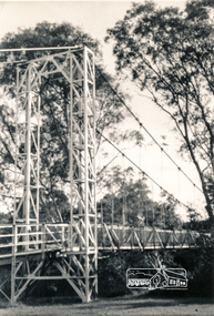 Eltham District Historical Society Inc
Photograph, Pedestrian suspension bridge over the Yarra River at Lower Plenty
Odyssey House drug rehabilitation centre in Bonds Road, Lower Plenty is a distinctive landmark, especially when viewed from across the Yarra at Templestowe. It was built in the 1950’s as a seminary for the Blessed Sacrament Fathers. Because of the poor and circuitous road access, a suspension footbridge was built across the river. As well as providing easy access for the priests residents of Templestowe could attend services at the seminary. The bridge is now part of the Yarra Trails system.Two black and white photographs of footbridge over Yarra River, part of the Ruffey Trail just off the Main Yarra Trail near the former seminary (now Odyssey House) Lower Plentybridges, yarra river, odyssey house, bonds road, lower plenty, seminary, blessed sacrament fathers -
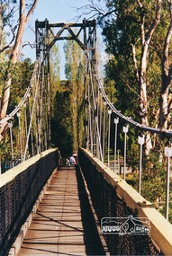 Eltham District Historical Society Inc
Photograph, Pedestrian suspension bridge over the Yarra River at Lower Plenty
Odyssey House drug rehabilitation centre in Bonds Road, Lower Plenty is a distinctive landmark, especially when viewed from across the Yarra at Templestowe. It was built in the 1950’s as a seminary for the Blessed Sacrament Fathers. Because of the poor and circuitous road access, a suspension footbridge was built across the river. As well as providing easy access for the priests residents of Templestowe could attend services at the seminary. The bridge is now part of the Yarra Trails system.Colour photograph of footbridge over Yarra River, part of the Ruffey Trail just off the Main Yarra Trail near the former seminary (now Odyssey House) Lower Plentybridges, yarra river, lower plenty, seminary, blessed sacrament fathers, odyssey house, bonds road -
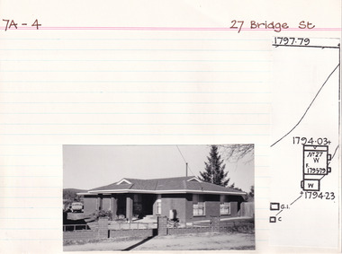 The Beechworth Burke Museum Research Collection
Card (Series) - Index Card, George Tibbits, 27 Bridge Street, Beechworth, 1976
George Tibbits, University of Melbourne. Faculty of Architecture, Building and Town & Regional PlanningIndex system that support the research for Beechworth : historical reconstruction / [by] George Tibbits ... [et al]Arranged by street names of BeechworthEach index card includes: street name and number of property, image of property, allotment and section number, property owners and dates of ownership, description of the property according to rate records, property floor plan with dimensions.beechworth, george tibbitsbeechworth, george tibbits -
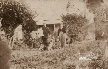 Eltham District Historical Society Inc
Photograph, Mrs Henry Hill (nee Georgina Reynolds of Research) and others outside the old Hill residence in Bridge Street, Eltham
Early settlers of Eltham Black and white photograph postcardMrs Henry Hill (nee Georgina Reynolds of Research), mother of John Ernest Hill. Identity of others not known to Mrs A.E. Hill , who states 'photo was taken outside the old Hill residence, Bridge St, (south side between Susan and Bolton Streets). Demolished many years ago - 26.7.65 Also stamped - Shire of Elthamhouses, mrs henry hill, bridge street, georgina hill (nee reynolds), hill family, hill family home, john ernest hill -
 Clunes Museum
Photograph, BAWDEN PHOTOGRAPHER
PHOTO COPY OF SUSPENSION BRIDGE IN CREEK PARADE CLUNES, TAKEN FROM COUNDON STREET, CLUNES.SUSPENSION BRIDGE CLUNES. BAWDEN PHOTOSlocal history, photography, photographs, bridges and buildings -
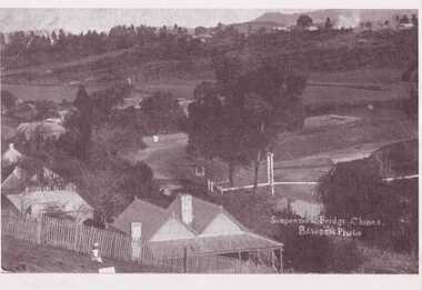
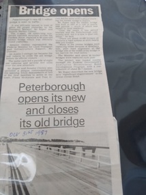 Peterborough History Group
Article - Bridge Opens in Style
Article about the opening of the New Bridge and closing of the Old Bridge.Decribes the ceremonies and plaque dedication of the opening of the new bridge and closing of the old bridgeTwo column article about the opening of the new bridge and closing of the old bridgeHandwritten date.peterborough, peterborough old bridge, peterborough new bridge, curdies river bridge -
 Kew Historical Society Inc
Photograph, Marnie McLeod, Floods on the River Yarra at Kew, 1916
The donation was accompanied by the following letter from the donor: "Hi. I found these in with family photos. Taken by family as Mamie McLeod was living in Fellows Street, Kew, so would be near there. Retain (or discard) as you see fit." [Donor's name and address withheld from public view]. To gain an insight into the flood levels at Kew, it is worth reading newspaper accounts of the event. The Age published an article - Valuable Gardens Destroyed at Kew - on 25 September 1916: "VALUABLE GARDENS DESTROYED AT KEW. From the heights of Studley Park, Kew, a splendid view of the flood waters can be obtained, and yesterday afternoon, despite continuous rain, crowds of citizens assembled there to witness the spectacle. There is a vast stretch of water some 300 or 400 yards broad, above the foot bridge connecting Gipps-street, Collingwood, and Studley Park. The river is only about 3 feet from the top of the embankment connecting with the ramp of the bridge on the Studiey Park side. When the upper llood waters come down it is almost a certainty that tne embankment will be submerged and the bridge rendered impassible. Below the bridge the waters again stretch out, and have submerged all the low-lying land on the Collingwood side and invaded the back premises ot the Kodak Co., Phoenix Biscuit Factory, a tannery adjoining thereto, the Shamrock Brewery, and Chinese gardens in the vicinity. At Walmer-street-bridge, at the end of Studley Park, the low-lying land on the Kew side is covered with water to the depth of many feet. Tlie land in question is owned in a great part by Mr Frank Lavers who haa gone in for intense culture on a pretty liberal scale on both the slopes of the hill and on the river flat. On the latter he is cultivating many acres of asparagus, and has at a considerable cost spent three years in preparing the ground and installing an irrigation system, reticulated from the Yan Yean water supply. This year the asparagus was put down, and the plants were in a promising condition. Tlie flood waters are now flowing fast over the land. The crop is ruined, and three years' work and expenditure destroyed. Mr. Laver's private residence fortunately is high above flood level, but two houses he owns off Young-street have been flooded out. Having been warned in time, the tenants removed their furniture hefore the water came down to Mr. Laver's residence, where they themselves have been given accommodation in the meantime. All the river flats in East Kew are under water. One or two low-lying houses have been flooded. Chipperfield's boat shed at Willsmere is nearly covered, and some Chinese gardens in the vicinity are several feet under water."This, and the other three photographs donated of floods in Kew are believed to be the earliest in the collection. Together with our original MMBW River Yarra map showing flood levels, these items, when compared allow researchers to gain a visual perspective of the extent of the flood in 1916. Panoramic view, believed to be looking north towards Fairfield from the Zig-Zag Bridge on the River Yarra. The inscription on the reverese identifies it as taken before 1920.Inscription on reverse in ink "(pre 1920) Flood from Zig-zag bridge Yarra River, Kew Vic."river yarra, kew, floods 1916, zig-zag bridge -
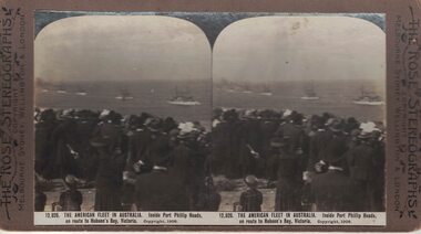 Linton and District Historical Society Inc
Stereograph, The Rose Stereographs, Melbourne, Sydney, Wellington and London, 12,826. The American Fleet in Australia, Copyright 1908
One of two sets of stereographs donated by the O'Beirne family along with a stereoscope for viewing (Stereoscope is Registration no. 2014-51).Stereographic image showing a ship from the American Fleet on the water in Port Phillip Bay."12,826. THE AMERICAN FLEET IN AUSTRALIA. Inside Port Phillip Heads, / en route to Hobson's Bay, Victoria."stereographs, american fleet