Showing 1515 items
matching sanding
-
 Ballarat Tramway Museum
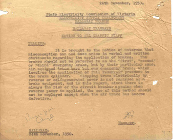
Document - Instruction, State Electricity Commission of Victoria (SECV), "Braking", Nov, 1950
Significant in being a sheet regarding tramcar braking systems and how considered at the time - 1950. No mention of sand in braking technique.Was contained within Reg Item 3519 in which located in the filing cabinet 8/2006. Small typed carbon copy instruction or "Notice to All Traffic Staff" titled "Braking", discussing the names of emergency brake. Notes air braked trams have on emergency brake only - the air brake. Stopping trams electrically is not regarded as brake equipment, and should not be used unless air brake is defective. Dated 24/11/1950. See Reg Item 271 and 3457 for later issues of instructions on the same matter.Initialled in ink by the Manager and a note in ink "please ??"trams, tramways, ballarat, secv instructions, braking, operations -
![Vehicle - HMAS Lonsdale [HMVS], Built in 1884](/media/collectors/4f729f7e97f83e03086018d1/items/4fd575aa2162ef0ecc023165/item-media/613b16c26b487cd5e2ab7cba/item-fit-380x285.jpg) Queenscliffe Maritime Museum
Queenscliffe Maritime MuseumVehicle - HMAS Lonsdale [HMVS], Built in 1884
Transported to Victoria as deck cargo aboard s.s. Port Darwin. This vessel was ordered by Government of Victoria and was only used in training exercises in Port Philip and had become outmoded by the time the Royal Australian Navy was formed in 1911.Buried by sand in the grounds of the Queenscliffe Maritime Museum. There is no known record of how the "Lonsdale" ended abandoned on the beach at Queenscliff. Originally the land where the QMM is situated was the foreshore at the back of the houses in Beach Street, Queenscliff. There were two Torpedo boats built in 1884, the Lonsdale and the Nepean.Site of the buried remains of the Torpedo Boat HMAS Lonsdale [HMVS]hmas lonsdale, hmvs lonsdale, victorian navy, port phillip, royal australian navy -
 Queenscliffe Maritime Museum
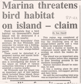
Newspaper - Newspaper clippings re Sand Island issues, Sand Island matters Queenscliffe, 1987
Port Phillip island issuesVictorian historyNews articles re Port Phillip islands & their issuesReverse " NIL "historical references -
 Bayside Gallery - Bayside City Council Art & Heritage Collection
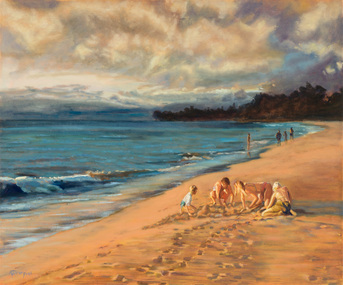
Painting - oil on board, Thel Cardwell, Last light, 1992
This painting was entered into the Annual Brighton Art Exhibition in 1992 and was the winner of Brighton City Council Acquisitive Award category.Thel Cardwell, Last light 1992, oil on board, 74.8 x 90 cm Bayside City Council Art and Heritage Collection. Purchased 1992beach, coast, thel cardwell, last light, sand, children, recreation, brighton art exhibition, brighton rotary -
 Bayside Gallery - Bayside City Council Art & Heritage Collection
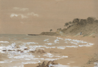
Painting - Work on paper, Sandringham Beach, 1868
watercolour, gouache and pencilsandringham, beach, coast, watercolour, surf, sand, vegetation, pier, stone hut, landscape -
 Bayside Gallery - Bayside City Council Art & Heritage Collection
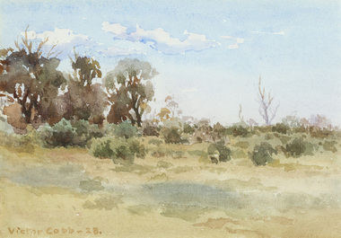
Work on paper, Victor Cobb, Evening Hampton, 1923
watercolourhampton, evening, beach, foreshore, landscape, victor cobb, coast, bayside, sand, shrub, tree -
 Bayside Gallery - Bayside City Council Art & Heritage Collection
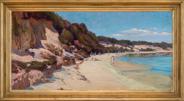
Painting - oil on canvas, Stewart Handasyde, Hampton beach, c. 1914
Stewart Handasyde, Hampton beach c. 1914, oil on canvas, 65 x 131 cm. Bayside City Council Art and Heritage Collection. Donated by the Handasyde family, 2018.hampton, beach, bayside, water, figures, sand, bathers, coast, handasyde, stewart handasyde -
 Queenscliffe Maritime Museum
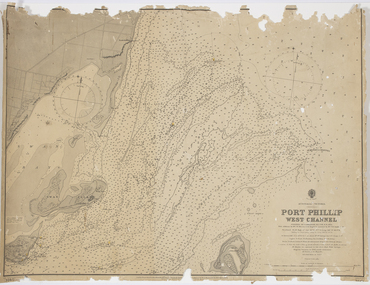
Map - Survey Charts, Port Phillip West Channel
These charts show changes to the depth levels surrounding Queenscliff. Earlier chart does not show the cut which can be seen in the later chart. The creation of the cut and subsequebt dredging of it has changed the shoreline due to shifting sand.Two charts of the Port Phillip West Channel, reference number 309. One was engraved in 1903, the other a new 1935 edition last revised in 1961.Port Phillip West Channelport phillip, queencliff channel, charts, soundings -
 Moorabbin Air Museum
Book - American Fighters in Original WWII Color, FIGTHER COMMAND American Fighters in Original WWII Color, FIGTHER COMMAND American Fighters in Original WWII Color, 1991
American Fighters in Original WWII Color, FIGTHER COMMAND American Fighters in Original WWII ColorJacket showing colour photo of Thunderbolts preparing for takeoffnon-fictionAmerican Fighters in Original WWII Color, FIGTHER COMMAND American Fighters in Original WWII Color -
 Round the Bend Conservation Co-operative
In a transpiration bed realn drains, screenings, sand and soil filter the water which is then expired by the plants
-
 Federation University Art Collection
Ink, Acrylic and cotton on stretch fabric, Blanford, Anna, 'I Can't Hear you My Head is in the Sand' by Anna Blanford, 2001
This item is part of the Federation University Art Collection. The Art Collection features over 1000 works and was listed as a 'Ballarat Treasure' in 2007.art, artwork -
Federation University Art Collection
Printmaking - Etching. Aquatint, Watkins, Debra, The Sand Sifter, 1971
This item is part of the Federation University Art Collection. The Art Collection features over 1000 works and was listed as a 'Ballarat Treasure' in 2007.art, artwork -
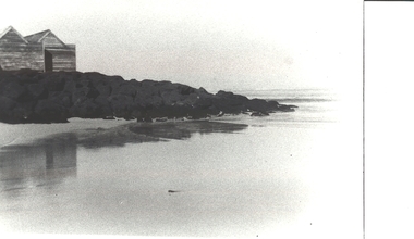 Port Fairy Historical Society Museum and Archives
Photograph
Black and white photograph of the bathing boxes on the left had side and the sea to the rightBathing boxes south beachbathing boxes, south beach, sea, sand, ocean -
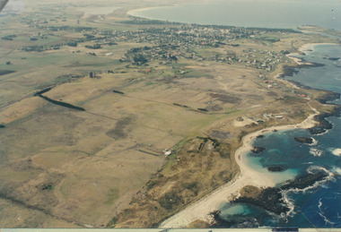 Port Fairy Historical Society Museum and Archives
Photograph
Aerial view of Port Fairy WestColoured aerial photographsand hill cemetery, water tower, west -
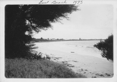 Port Fairy Historical Society Museum and Archives
Photograph
East Beach 1973Black and white photograph of East Beach with she oaks on the left and Norfolk Island pine in distanceNovember 1973 kodakeast beach, battery hill, ocean, sea, sand -
 Port Fairy Historical Society Museum and Archives
Photograph, March 1960
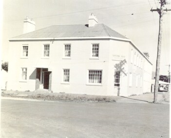
The Stag Hotel The Stag was built 1848-1854. John Sanders purchased the land from Atkinson in 1848 and built the building as a licensed premises. Over the years it was also used as a Hotel, boarding house and boarding school. It is still used today as Accommodation and a restaurant. This photo is printed in reverse..Black & white photograph of the Sackville street frontage of the Stag Hotel or Seacombe House as now KnownSeacombe House (Back to Front) Port Fairy March 1960hotel, stag, seacombe, sackville street, stag hotel, john sandeers, boarding school, boarding house, coffee palace -
 Port Fairy Historical Society Museum and Archives
Photograph
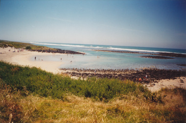
South beach Pea SoupColoured photograph pea soup, south, beach, sand -
 Port Fairy Historical Society Museum and Archives
Photograph
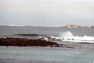
East beach from reefplus photographic copyeast beach, sea, ocean, reef, sand, waves -
 Port Fairy Historical Society Museum and Archives
Photograph - photocopy
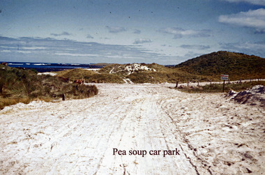
Pea soup car parkpea soup car parkpea soup, car park, sand, road, track -
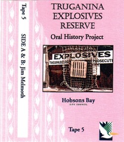 Truganina Explosives Reserve Preservation Society Inc (TERPS)
Digitised Oral History – Truganina Explosives Reserve - Tape 9 Andrew Shannon and Judy Hindle, 2018
The interviews were recorded in 2000 by Bronwen Gray and Alan Young for the production of Unreserved, Stories from Truganina Explosives Reserve, animated stories from past residents, workers and interested people of the Reserve (subject to copyright 2004). Judy Hindle and Andrew Shannon worked jointly on saving the Truganina Explosives Reserve from being sold for development by the State Government. Judy was an Altona resident and Andrew was an environment planner, first with Parks Victoria and then the local council. Their motivation was to not only save the site for open space but to capture what Judy described as the only in-tact historical site in the area. A primary source of information on memories of the Truganina Explosives Reserve and Altona,VictoriaDigital copy of original cassette recorded in 2000 and digitised in 2018chirnside, explosives, tin fence, coastal vegetation, parks victoria, joan kirner, cheetham wetlands, doug grant, gahnia, salt marsh, sand ridges, rob andrew, nessie hardy, aboriginal middens, altona, truganina swamp -
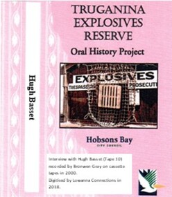 Truganina Explosives Reserve Preservation Society Inc (TERPS)
Digitised Oral History – Truganina Explosives Reserve - Tape 10 Hugh Basset, 2018
The interviews were recorded in 2000 by Bronwen Gray and Alan Young for the production of Unreserved, Stories from Truganina Explosives Reserve, animated stories from past residents, workers and interested people of the Reserve (subject to copyright 2004). As the then President of the Inner West Branch of the National Trust, Hugh was unaware of the Truganina Explosives Reserve until contacted by Nessie Hardy about the proposed sale of the site by the State Government. He was struck by the industrial, environment and indigenous significance of the site A primary source of information on memories of the Truganina Explosives Reserve and Altona,VictoriaDigital copy of original cassette recorded in 2000 and digitised in 2018nessie hardy, cheetham salt works, migratory birds, explosives reserve, explosives, point gellibrand, national trust, tin fence, sand ridges, altona skipper butterfly, middens, aboriginal occupation, judy hindle -
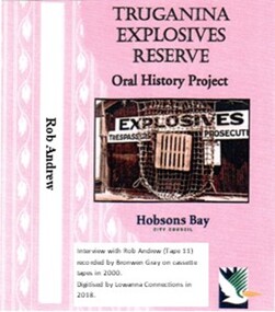 Truganina Explosives Reserve Preservation Society Inc (TERPS)
Digitised Oral History – Truganina Explosives Reserve - Tape 11 Rob Andrew, 2018
The interviews were recorded in 2000 by Bronwen Gray and Alan Young for the production of Unreserved, Stories from Truganina Explosives Reserve, animated stories from past residents, workers and interested people of the Reserve (subject to copyright 2004). Rob Andrew’s career was as an Environmental Health Officer with various councils around Victoria. As an Altona resident he became interested in the Truganina Explosives Reserve when he heard the site was to be sold. He was concerned that because of the prospect of commercial development the community would lose tranquil open parklands. Through his involvement with the Reserve he realised the historical, geomorphic, flora and fauna significance of the site. A primary source of information on memories of the Truganina Explosives Reserve and Altona,VictoriaDigital copy of original cassette recorded in 2000 and digitised in 2018native grasses, explosives, cheetham wetlands, cheetham salt works, doug grant, chirnside, cliff gibson, lava plain, brown coal, sand ridges, selwyn fault, rowsley fault, victorian coastal strategy, aboriginal stone artefacts, aboriginal habitation, aboriginal remains, red gums, casuarinas, altona skipper butterfly, orange bellied parrot -
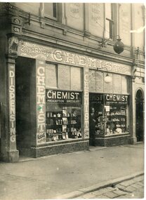
 Kadimah Jewish Cultural Centre and National Library
Photograph - Bezalel (Zal) Markov's Chemist at the corner of Elgin and Drummond St, 1920s
An image Bezalel (Zal) Markov's Chemist in Carlton. Markov was President of the Kadimah in 1918.kadimah jewish cultural centre, z. markov, bezalel markov, lois sandor, kadimah presidents, jewish carlton, carlton, chemist -
 Kadimah Jewish Cultural Centre and National Library
Photograph - Bezalel (Zal) Markov's second Chemist Shop at 144 Elgin St, Carlton
An image Bezalel (Zal) Markov's Chemist in Carlton. Markov was President of the Kadimah in 1918.kadimah jewish cultural centre, z. markov, bezalel markov, lois sandor, kadimah presidents, jewish carlton, carlton, chemist -
 Kadimah Jewish Cultural Centre and National Library
Photograph - Portrait of Bezalel (Zal) Markov
A portrait of Bezalel (Zal) Markov. Markov was President of the Kadimah in 1918.kadimah jewish cultural centre, z. markov, bezalel markov, lois sandor, kadimah presidents, jewish carlton, carlton, chemist -
 Kadimah Jewish Cultural Centre and National Library
Photograph - Portrait of a young Bezalel (Zal) Markov
An image of Bezalel (Zal) Markov. Markov was President of the Kadimah in 1918.kadimah jewish cultural centre, z. markov, bezalel markov, lois sandor, kadimah presidents, jewish carlton, carlton, chemist -
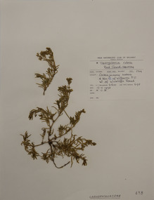 Federation University Herbarium
Plant specimen, Alexander Clifford Beauglehole, Spergularia rubra (L.) J.Presl & C.Presl, 17/11/1978
Cliff Beauglehole was an orchardist at Portland, Victoria, who throughout hislife took an intense interest in the plants of Victoria. Over his lifetime he collected 90,000 plant specimens as part of a comprehensive study of Victoria's plants and wrote thirteen books under the heading The Distribution and Conservation of Vascular Plants in Victoria, each written to cover the 13 study areas of the Victorian and Conservation Council.A mounted botanical specimen.beauglehole herbarium, herbarium specimen, botany, herbarium, plant science, plant specimen, field naturalists' club ballarat, federation university herbarium, spergularia rubra, caryophyllaceae, red sand-spurrey -
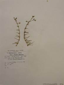 Federation University Herbarium
Plant specimen, Alexander Clifford Beauglehole, Spergularia rubra (L.) J.Presl & C.Presl, 16/11/1978
Cliff Beauglehole was an orchardist at Portland, Victoria, who throughout hislife took an intense interest in the plants of Victoria. Over his lifetime he collected 90,000 plant specimens as part of a comprehensive study of Victoria's plants and wrote thirteen books under the heading The Distribution and Conservation of Vascular Plants in Victoria, each written to cover the 13 study areas of the Victorian and Conservation Council.A mounted botanical specimen.beauglehole herbarium, herbarium specimen, botany, herbarium, plant science, plant specimen, field naturalists' club ballarat, federation university herbarium, spergularia rubra, red sand-spurrey, caryophyllaceae -
City of Kingston
Photograph - Colour, 29 January 1993
Bonbeach is a small beachside suburb located between Chelsea and Carrum. The station was opened in 1926 and was the last to be established in the group from Aspendale to Carrum. Urban growth began after World War II. State primary and high schools were opened in 1958 on land in Breeze Street that was once occupied by The Australian Glass Manufacturers. Immediately east of the school sites is the Patterson River Golf Club. The Bonbeach sports reserve has five ovals and is home to the Bonbeach football and baseball clubs. The suburb borders the Edithvale-Seaford Wetlands which is the remnant site of the Carrum Carrum swamp, once the home of the Bunurong people.Bonbeach was originally a seaside destination for holidaymakers and the housing comprised of holiday homes and gradually more permanent residents. It was not until 1926 that Bonbeach had its own railway station. From 1906 until the late 1940s sand was quarried on the east side of the railway line and used in the manufacture of glass. The Australian Glass Manufacturers sold this land in residential blocks and Bonbeach's permanent population spread from the coastal strip across to the other side of the railway line. Laminated colour aerial photograph of the suburb of Bonbeach and also the southern section of neighbouring Chelsea within the City of Kingston. The extent of this 1993 aerial image includes: Top left - Maury Road at the south end of the Chelsea shopping Centre; Top right - Scotch Parade Chelsea Bottom left - Monica Avenue in Bonbeach; Bottom right - Patterson River Golf Club. Landmarks include St Joseph's Church and Primary School, Chelsea Primary School, Bonbeach Station, Bonbeach Fotball Club sports playing fields and Bonbeach Life Saving Club. The Edithvale Wetlands is featured prominently to the right-hand side of the image. Black typed writing on white adhesive label: No. 6662 Black typed writing on white adhesive label: 26E/6662, 29/1/93, 4.25 pm Black typed writing on white adhesive label: 29-1-93 Black typed writing on white adhesive label: P000109 Circular yellow adhesive sticker bonbeach, chelsea -
City of Kingston
Photograph - Colour, 1993
Carrum is a suburb in the City of Kingston bordered by the Patterson River in the north and Kananook Creek in the south. To the east the suburb is adjacent to Patterson Lakes. The Carrum Station was opened in 1882, when the railway line from Mordialloc was extended to Frankston. In the early 20th century, it was a destination for holidaymakers occupying tents and cabins. The area now consists of older housing and over time there have been many new housing developments.Carrum is located in the area that was originally part of the Carrum Carrum Swamp. The district had originally been the home of the Bunerong people who fished, gathered food and found refuge in the sand dunes. The Swamp was drained in 1879 when the Patterson Cut was formed and became known as Patterson River. Apart from local farmers, fishermen and hotel-keepers, there were few permanent residents until the early 20th century when it had become popular as a beach resort. In the 1920s and 1930s the area became occupied by more permanent residents.Laminated aerial colour photograph of Carrum and Patterson Lakes in the City of Kingston. The photograph also includes Kananook Creek and the northern section of Seaford. Prominent features include Roy Dore Reserve, Carrum Primary School, Patterson River Secondary College, Keast Park Seaford, the Seaford Swamp Drain and a section of Downs Estate situated on the traditional lands of the Bunurong people.Black type on white adhesive sticker: No. 7140 Black type of white adhesive sticker: 31-1-93 Black handwritten ink (marker): * [an asterisk] Yellow circular adhesive stickerpatterson lakes, seaford, carrum carrum swamp