Showing 1889 items
matching settler societies
-
 Whitehorse Historical Society Inc.
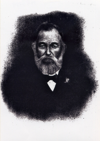
Photograph, John McDonnell
Black and white photo of a print of John Donnell (died 27-4-1921) an early settler and owner of the original Reserve Hotel in Mitcham. Donnell was known as McDonnelldonnell, john, mcdonnell, reserve hotel, mitcham -
 Whitehorse Historical Society Inc.
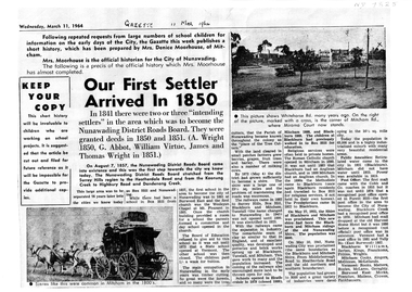
Article, Our First Settler Arrived 1850, 11/03/1964
A4 photocopy of the history of the City of Nunawadingnon-fictionA4 photocopy of the history of the City of Nunawadingnunawading district roads board, city of nunawading -
 Ballarat Heritage Services
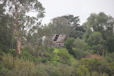
Photograph - Photograph - Colour, Lisa Gervasoni, Remains of Angus McMillan's Bushy Park Home, 2014, 07/06/2014
Angus McMillan was born in 1810 at Glenbrittle in the Isle of Skye. He was one of fourteens sons of Ewan McMillan. Angus McMillan arried i New South Wales in January 1839, and became an overseer for Captai nLachlan Macalister. I n 1839 Angus McMillan travelled south. He settled for a time on Jame MacFarlane's statin at Currawong. IOn 28 May 1839 Angus MacMillan stated travelling southward toward the coast. Angus Macmillan named the Avon River after the river of the same name in his native Scotland. In 1840 he established a pastoral run at Bushy Park, near Maffra. William Odell Raymond established a run in the area in 1842, and built his house, Strathfieldsaye, during 1848–54. European settlement did not take place without resistance, and in return, massacres were inflicted by Angus McMillan and others on Gunai people, especially between the years of 1840 and 1850. (wikipedia) The first application for the 'Bushy Park' run appears in the “Port Phillip Gazette” on 13 August 1843. It was taken up by Angus McMillan, who also took up the 'Boisdale' run for his employer Lachlan Macalister at the same time. In March 1844 a Licence to occupy the 16,000 acre 'Bushy Park' was granted to McMillan. In the late 1840s Andrew Martin and Matt McCraw built Angus McMillan's Bushy Park homestead. Aboriginal killings in Gippsland area most often were never formally recorded, but lived on in folklore, mainly in place names pinpointing what some historians now refer to as "massacres", and others as "conflicts". There is Boney Point, on Lake Wellington, Butchers Creek, near Metung, Slaughterhouse Gully, at Buchan, Skull Creek, at Lindenow, and, notoriously, Warrigal Creek, at Woodside. "Here, according to a couple of contemporary - though not eyewitness - reports, between 50 and 150 blacks were killed in an orgy of revenge after the murder and mutilation of a leading Scots settler, Ronald Macalister. If anybody had any doubts about the fitness of commemorating McMillan's name, no one voiced them then. Gippsland was, and still is, dotted with stone cairns tracing his route from Omeo, down the Tambo Valley to the fertile plains where he was to make (and lose) his fortune. And where, according to a growing body of opinion, he was to lead the "Highland Brigade", a band of armed settlers, against the Kurnai. History is fiction agreed on, and it is written by the winners. For most of the past 150 years, McMillan has been hailed as a trail-blazing pioneer. The legend began to crumble 20 years ago with publication of new histories, which at first outraged Gippsland historical societies and old residents, but which have gradually changed the way McMillan is viewed. ... Still, not all McMillan's contemporaries agreed with the "Highland Brigade" and its methods. Henry Meyrick, an English-born squatter, wrote to relatives in disgust about his neighbours. He estimated that 450 had been killed, and wrote: "Men, women and children are shot down whenever they can be met with. Some excuse might be found for shooting the men by those who are daily getting their cattle speared, but what they can urge in their excuse who shoot the women and children I cannot conceive." (http://www.theage.com.au/articles/2002/04/26/1019441303552.html, accessed 20 September 2016.) The Gippsland electorate is called 'McMillan' in his honour. Photographs of the remains of a timber home used by squatter Angus McMillan at his "Bushy Park" property on the Avon River. angus mcmillan, bushy park, avon river, squater -
 Lakes Entrance Regional Historical Society (operating as Lakes Entrance History Centre & Museum)
Photograph, 1999
John B Carpenter left 100 pounds in his Will to enable the Tambo Shire Council to plant this avenue in memory of John Carpenter, see Item 18 in Tambo Shire Council Minutes, 15 August 1967.Colour photograph of the avenue of Queensland Box trees, Tristiana conferta, in Roadknight Street, planted as a memorial to John Carpenter, early settler of Gippsland and main contractor of the building of the man made entrance through to the sea. Lakes Entrance Victoriapublic utilities -
 Lakes Entrance Regional Historical Society (operating as Lakes Entrance History Centre & Museum)
Photograph, 1985
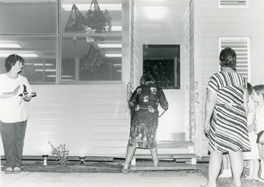
Lady cutting ribbons Mrs Doreen Robinson, a past student and descendent of earlier settler E Burt. Lady with microphone identified as Mrs Val Walton, and lady watching with children identified as Mrs Lin Winnett.Black and white photograph of Mrs D Robinson cutting ribbons across the doorway at the newly installed portable class room at primary school opening ceremony. Val Walton with microphone clapping, Lyn Winnett with children looking on. Johnsonville Victoriaschools, celebrations -
 Lakes Entrance Regional Historical Society (operating as Lakes Entrance History Centre & Museum)
Photograph, Bessie Larkins, 1994 c
O'Rourke family believed to be the first settlers in Buchan area, faving runs at Suggan Buggan Black Mountain WulgulmerangColour photograph of the O'Rourke family grave at the old Black Mountaine homestead Black Mountain Victoriaalpine region, waterways -
Lakes Entrance Regional Historical Society (operating as Lakes Entrance History Centre & Museum)
Photograph, H D Bulmer, 1904 c
Sepia toned photograph of a bark house in bushland with glazed sash windows of six panes upper and lower. Large chimney of dropped slabs held in place by narrow uprights. Known as Northropes Bunga Haven Lake Bunga Victoriabuildings, settlers -
Lakes Entrance Regional Historical Society (operating as Lakes Entrance History Centre & Museum)
Photograph, H D Bulmer, 1910 c
Black and white photograph of a settler and his family around their bark hut in the bush. A primitive shelter of bark slabs stabilised with a log and iron frame attached to roof ridge. Situated near Nowa Nowa Victoriahouses, settlers -
Lakes Entrance Regional Historical Society (operating as Lakes Entrance History Centre & Museum)
Photograph, Lakes Post Newspaper, 1994
Black and white photograph of steps leading down to Blackfellows Arm Lake Tyers area Victoriahouses, settlers -
Lakes Entrance Regional Historical Society (operating as Lakes Entrance History Centre & Museum)
Photograph, 2016 c
Oneonta was donated to Lake Tyers community later aquired by East Gippsland ShireColour photograph of grounds of Oneonta former property of Jack and Dylas Ramsdell Lake Tyers Beach Victoriahouses, settlers -
Lakes Entrance Regional Historical Society (operating as Lakes Entrance History Centre & Museum)
Photograph, M Fish, 2010 c
Also a second colour photograph of the grave of a Fish family member who were settlers at Bumberrah 04980.1 10 x 15 cmColour photograph of grave and headstone of members of the Fish family in the Bumberrah Cemetery near Johnsonville Victoriacemeteries, memorials -
Lakes Entrance Regional Historical Society (operating as Lakes Entrance History Centre & Museum)
Photograph, M Holding, 2010 c
Also buried in the grave is Mrs Alice Stocks buried 1955. This fact verified by family members who attended including grand daughter Bette Archer of Maffra. Funeral director mistakingly recorded the burial at BairnsdaleColour photograph of headstone on graves of George and Sarah Grant early settlers of Metung in the Bumberrah Cemetery near Johnsonville Victoriacemeteries, memorials, settlers -
Lakes Entrance Regional Historical Society (operating as Lakes Entrance History Centre & Museum)
Photograph, Stella Rau
Colour photograph taken at the old cemetery at Cassilis Victoriacemeteries, genealogy, settlers -
Lakes Entrance Regional Historical Society (operating as Lakes Entrance History Centre & Museum)
Photograph, 2010 c
The Hay-Smith family were pioneers of the Bengworden areaSepia toned photograph of the Hay-Smith grave in an unnamed cemetery in East Gippsland Victoriacemeteries, settlers -
Lakes Entrance Regional Historical Society (operating as Lakes Entrance History Centre & Museum)
Photograph, 1/11/1959 12:00:00 AM
Black and white photograph taken at the opening of A Trevaskis, D Tham, D Hardwidge, C Answer, W Davies, J Appleby, J Thom, J Henderson, C McMahan, T Hardwidge the men who were involved in the building of the community hall at Wairewa Victoriacemeteries, settlers -
Lakes Entrance Regional Historical Society (operating as Lakes Entrance History Centre & Museum)
Photograph, M Fish, 1970 c
Kalimna West was a thriving community 1900 to WW2 many farmers growing vegetables for local and Melbourne marketsColour photograph of derelict settlers home and out buildings Kalimna Road Kalimna West Victoriawaterways -
Lakes Entrance Regional Historical Society (operating as Lakes Entrance History Centre & Museum)
Photograph, 1926 c
Also an enlarged copy of same photograph 05006.1 Built by J C Dahlsen for Vic Fish and family. Became shell museum 1960 to 70s for Mrs Newmans Camp Park named Gelia changed to Echo Beach, had various ownersBlack and white photograph of a small fibro clad house built for Vic and Myrtle Fish surrounded by receeding flood waters in Roadknight Street Lakes Entrance Victoriahouses, settlers -
Lakes Entrance Regional Historical Society (operating as Lakes Entrance History Centre & Museum)
Photograph, 1947
Also identical photograph number 03842.1 size 8 x 10.5 cmBlack and white photograph showing Eastern shore with heavily timbered background taken from Western shore Lake Bunga Victoriabuildings, people, settlers -
 Lakes Entrance Regional Historical Society (operating as Lakes Entrance History Centre & Museum)
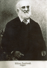
Photograph, 1890 c
Black and white photograph of William Roadknight taken in his later years showing an elderly man with white beard and hair, dressed in dark suit, white shirt and striped tie, pioneer settler of Lakes Entrancegenealogy, celebrations -
 Lakes Entrance Regional Historical Society (operating as Lakes Entrance History Centre & Museum)
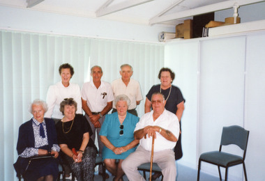
Photograph
Colour photograph of eight people five of the group are descended from George and Sarah Grant settlers at Shaving Point Metunggenealogy, transport -
 Numurkah & District Historical Society
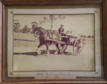
Photo - Horse & cart
Sepia photo of a person in a horse & cart. Photo is outlined by a cream (& gold decoration) mounting board, inside a wooden frame with glass.(see photo) Front: 150th Anniversary Celebrations 31-3-1985 Back: Re-enactment of the arrival of first settlers to the district. Staged by the Numurkah Historical Society during Victoria's 150th Anniversary Celebrations 1985horse, cart, first settlers, victoria's 150th celebrations, re-enactment -
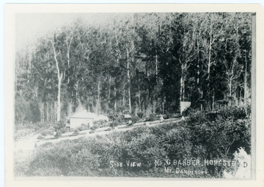 Mt Dandenong & District Historical Society Inc.
Photograph, Side View Mr G. Barber Homestead Mt Dandenong, c1905
Built in 1898 by early settler George Barber the property is still in existence today. It was the home of George, wife Sarah Ann and daughter Ethel.Black and white photograph showing te side view of George Barber's home, later named Forest Edge. c1905. Reverse of photograph has handwritten description by John Lundy-Clarke.Barber's home on Olinda Creek. Lot 25 Sect 1 Village Settlement. Home of George Barber and wife Sarah Ann (nee Richardson). Daughter Ethel.Was bought by Munnerley later Sangster and Kinnear. Later known as Forest Edge. Buggy and wagon shed on right. Photo copied 1973 by JLC. -
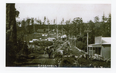 Mt Dandenong & District Historical Society Inc.
Photograph, Sassafras, c1915
The south end of Sassafras Main Street outside the Big Store (Sherrards), built in 1912 that sold a bit of everything. The early settler Arthur Goode, who arrived in 1893, originally owned the land. Arthur Goode ran the Post Office in a bark hut until he moved away in 1911. From 1912 the Post Office operated from a room in Hinkley Guest House from 1912 until 1937.Black and white copy of a GGM photograph of Sassafras. A man driving a horse and cart is coming up the road towards the camera while several couples can be seen strolling down the road. The early buildings of Sassafras are clearly visible.sherrards, sassafras, arthur goode, goode, hinkley, post office -
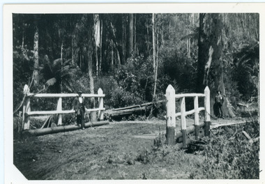 Mt Dandenong & District Historical Society Inc.
Photograph, Barber's Bridge on Olinda Creek
John Lundy-Clarke grew up in the Kalorama/Mt Dandenong area and later in life (1972-74) began to write a comprehensive history of the area working from an original settlement map in an effort to cover all areas. Barbers Bridge was named after George Barber, an early settler.Black and white photograph showing a man standing on a bridge over the Olinda Creek. 1910Handwritten n reverse: Barbers Bridge on Olinda Creek 1910. This was a ford crossed by the road after Isaac Jeeves selected allotment “C” “Jeeves Saddle” in 1871 and stopped travel through his property. The bridge has been built several times but at time of writing (1974) is replaced by a culvert consisting of two pipes two feet six inches wide. They are quite incapable of carrying the maximum flow of the creek and will be swept away.lundy-clarke, barber, barbers bridge, isaac jeeves, jeeves saddle, bridge, olinda creek -
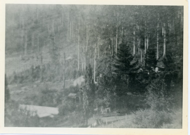 Mt Dandenong & District Historical Society Inc.
Photograph, View Over Roof of "Kalorama"
Taken in 1908, this photograph, though rather blurry, gives an indication of the location of the early settler properties in the valley in relation to one another. European trees have been planted at 'Kalorama' , the first home of Ellis Jeeves. John Lundy-Clarke grew up in the Kalorama/Mt Dandenong area and later in life (1972-74) began to write a comprehensive history of the area working from an original settlement map in an effort to cover all areas.Black and white photograph looking across hillside with large trees and rooftops visible. Handwritten description on reverse by John Lundy-Clarke.1908 View over roof of “Kalorama” towards the Falls. Paynter’s house on LOT 29 in low centre (now “Yosemite”). Pimms house on LOT 19 above Paynters and beyond scrub. Logan’s house faint above left of “Kalorama”. Dunbar’s LOT 20 beyond Pimm’s orchard. Gum trees on right were on Price’s LOT 19 now Tosari Rd area. It was one of these that figured in the episode of the runaway log in 1930. It leaped in one bound over Barbers Road at bottom of scrub in centre of picture then over Logan’s house.kalorama, ellis jeeves, jeeves -
 Mt Dandenong & District Historical Society Inc.
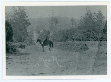
Photograph, Looking Down Falls Road
Edward John Price was a son of early settler Edward Joseph Price. Edward Joseph was the first settler in the Village Settlement when he took out Lot 1, Section 1. He built a small home of slabs and brought his family up in 1896. From the outset the Price family ran a store from their home.This picture, taken 1914, shows Edward John Price on his pony delivering papers from his parent's newsagency that was opposite 'Mountjoy' guesthouse on Ridge Road. He was taking them to Lily Badenhop's post office in Blythe's Road. The section of road he is on was called Main Road and is now Falls Road.Black and white photograph showing a man on horseback in the centre of an unmade road that is running into the distance.Trees, a fence and houses can be seen with hills in the background. Reverse of photograph has handwritten description by John Lundy-Clarke.On Front MAIN ROAD On Reverse Looking down Falls Road then the main road in 1914. Before Frank Craig built The Fron (1918). Dunbar’s house Halcyon on left of road. The hall on its right with Keogh’s sheds showing further in the trees. The horseman is Edward John Price who delivered the daily papers to Lil Badenhop’s shop. The bag he carried them in can be seen hanging from the saddle pommel. The first road formation can be seen on the bank to the right. The road seen was constructed 1905 by Bill McGivern.edward john price, edward joseph price, lily badenhop, post office, falls road, main road, mountjoy, frank craig, bill mcgivern, dunbar, halcyon, keogh, farndons hall -
 Mt Dandenong & District Historical Society Inc.
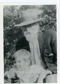
Photograph, Edward Joseph Price and Grandson
John Lundy-Clarke grew up in the Kalorama/Mt Dandenong area and later in life (1972-74) began to write a comprehensive history of the district working from an original settlement map in an effort to cover all areas. Edward Joseph Price took out Lot 1, Section 1 of the Village Settlement and became the first settler, moving his family up into a slab hut on his selection in 1896. Edward Joseph had two sons (Charles Joseph and Edward John) and a daughter (Kathleen Nathalie Caroline). Edward Joseph Price is holding his grandson Teddie, son of Edward John Price. Photo taken 1936.Black and white photograph in close up showing an old man with a white beard wearing a brimmed hat holding a male toddler under the arms. Reverse of photograph has handwritten description by John Lundy-Clarke.Edward Joseph Price and his grandson Teddie son of Edward John. E. Joseph was the first settler in the Village Settlement choosing LOT 1, part of which is still family property (1974). He worked for the surveyors who were marking out the blocks, and disregarded their advice as to which had the best soil, and so doing he obtained the best commercially. He died in 1943 leaving two sons & daughter. Edward John born 1899 died 1974. Charles born 1892 died 1958. Kathleen born 1895 died 1954. Wife Annie nee Ross died 1932.edward joseph price, edward john price, teddie price -
 Mt Dandenong & District Historical Society Inc.
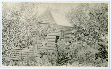
Photograph, Home and Shop of Edward Joseph Price
John Lundy-Clarke grew up in the Kalorama/Mt Dandenong area and later in life (1972-74) began to write a comprehensive history of the district working from an original settlement map in an effort to cover all areas. Edward Joseph Price was the first settler to take up a lot (Lot 1, Section 1) in the Village Settlement. He built a slab hut and brought up his family in 1896. This photograph shows a newer home built in 1908. It had a section used as a shop and also had a large room built that was to be used for public gatherings. Health department regulations led to this being impossible. The house faced Ridge Road.Black and white close up photograph showing a building made from wooden boards with trees in the front. Reverse of photograph has handwritten description by John Lundy-Clarke.On Front STORE MT DANDENONG On Reverse Home and Shop of Edward Joseph Price LOT 1 SECT 1 erected in 1908 on site of earlier dwelling from which goods had been sold without a special room for shop. In picture the room on the extreme left was bedroom for boys Charlie and Ted (Edward John). Under the gable was a large room planned for public use but never used owing to Health Department Regulations. The narrow door (open) and window were the shop which was the district’s first newsagency. Window behind leaves at right was the kitchen. 1908-1912. Gabled portion is now part of home “Mirra Laken” 1975edward joseph price, store, shop -
 Mt Dandenong & District Historical Society Inc.
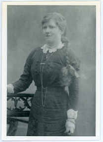
Photograph, Kathleen Price
Taken c1911, this photograph shows Kathleen Price (1894 - 1954) aged 18. Kathleen was the daughter of early settlers on Lot 1 of the Village Settlement, Edward Joseph and Annie (nee Ross) Price. Kathleen had two brothers - Charles born 1893 and Edward John born 1899. The family worked their business as equal partners. Kathleen married Frank Gardiner in 1916 and moved to Bateford , Geelong.Black and white studio photograph showing a young girl with a plait hanging over her left shoulder. Reverse of photograph has handwritten description by John Lundy-Clarke.Kathleen Price aged 18. Daughter of Edward Joseph Price and Annie Ada nee Ross. Married Frank Gardiner of Geelong (Batesford) in 1916. Children - two daughters and six sons. Died 1954.kathleen price, kathleen gardiner, frank gardiner, charles price, edward john price, edward joseph price, annie price, annie ross -
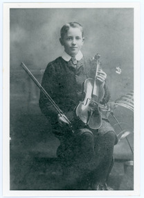 Mt Dandenong & District Historical Society Inc.
Photograph, Edward John Price aged 14
John Lundy-Clarke grew up in the Kalorama/Mt Dandenong area and later in life (1972-74) began to write a comprehensive history of the district working from an original settlement map in an effort to cover all areas. Edward John Price (1898 - 1974) was the son of early settlers on Lot 1 of the Village Settlement Edward Joseph Price and Annie (nee Ross) Price. He was the brother of Charles and Kathleen Price. Edward John married Myra Wilson in 1930.Black and white studio portrait showing well groomed boy holding a violin. Reverse of photograph has handwritten description by John Lundy-Clarke.Edward John Price aged 14. Son of Edward Joseph Price and Annie Ada nee Ross. Farmer, sawmiller, logging contractor,. proprietor of shop at Kew Junction 1935. Quarry master (Kilsyth). Father of Alan and Eddie J. A daughter died young. Married Myra Wilson 1930. Died 1974.edward john price, edward joseph price, annie price, annie ross, kathleen price, charles price