Showing 64046 items
matching house-prefects
-
 Glen Eira Historical Society
Article - Howitt Family
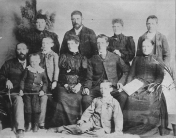
Photocopied extract on ‘The Howitt Family of Barragunda’ from ‘Early Pioneer Families of Victoria and Riverina’ includes black photos of family. Handwritten family tree – source unknown. Two handwritten foolscap sheets with extracts from Caulfield Rate Books, 1857-1891 where Howitt is listed as owner of properties, records tenants, addresses, size of property and value. Typewritten notes on the biography of Dr. Godfrey Howitt, outlines qualifications, endowments, interest, membership, no map included – it says Foot Survey Map. Howitt, Alfred William, typed and handwritten notes, references to house. Notes on publications written by Howitts, and the roles they undertook.bakewell, millman william, howitt godfrey dr., howitt john henry, howitt richard, howitt phoebe, mrs. nee godfrey bakwell, howitt william, howitt edward, howitt charles ernest, howitt edith mary, howitt alfred william, burke and wills expedition, king john, ‘rosemont’ kooyong rd, melbourne university, pioneer, botanist, naturalist, squatters, doctors, crotonhurst rd, caulfield, kooyong rd west, balaclava rd west, eyre rd, hume rd, howitt thomas, tantum phoebe, boothby benjamin judge, botham mary, millman william, mcwilliams robert, blake arthur palmer, grice james, spretchley edward, mcnaughton goerge, campbell john a., serle w.h., howitt mary, mickle royal society of victoria, st. mary’s church of england caulfield, stables, slab huts, police magistrate, authors -
 Glen Eira Historical Society
Document - Monkleigh, Gladstone Parade, 12, Elsternwick
Three items aout this property:1/Copy of pages from Andrew Wards, Caulfield Conservation study document dated October, 1994. Gives a brief history of land owners and occupants of Monkleigh and copy of photo dated October, 1994. The document includes a brief history and a description of the house features. 2/Hand written research by Claire Barton taken from 'Trove' regarding former resident of 'Monkleigh' who went to World War One. 3/Printout dated 18/02/2014 from Roll of Honour - Charles Clifton Elliott with location of his name at theralian War Memorial.elsternwick, hume lucy, kooyong park estate, gladstone parade, gladstone road, carlingford street, ellis jabez, webster joseph, wimberley colin, vale chas., judge g.t., ward andrew, architectural styles, victorian style, architectural features, monkleigh, elliot charles clifton, elliott charles clifton, elliot e b mrs, elliott e b mrs, house names, station managers, world war 1914-1918 -
 Eltham District Historical Society Inc
Slide - Photograph, 728 Main Road, cnr of Brougham Street, Eltham, May 1988, c.May 1988
728 Main Road, cnr of Brougham Street, Eltham, May 1988. Former Police House (1859) which at time of photo was the offices of the Shire of Eltham Parks and Environment. This photo was taken prior to the building of the replica Police Station to serve as a lunch room. The origional timber weatherboard building had been relocated around the rear of the residence years earlier but had since been demolished due to termite infestation. Ten years later (1998) the residence was made available by Nillumbik Shire Council for occupation by the Eltham District Historical Society (former Shire of Eltham Historical Society) to be used as their Local History Centre.35mm colour positive transparency (1 of 36) Mount - Kodak KodachromeProcess Date MAY 88Meltham, infrastructure, main road, brougham steet, eltham justice precinct, local history centre, parks and environment, police residence, shire of eltham -
 Eltham District Historical Society Inc
Work on paper (item) - Photograph, Little Models, 1961
Florence Ada Zull, known as Ada was an illustrator for the 'New Idea for Women" magazine. In 1961 she lived in Brunswick. From 1963 she and her husband Robert built a Alistair Knox designed house at 2 (lot 8) Metery Road, Eltham. In this issue Ada's son and daughter Susan model jumpers that were knitting competition prize winners at the Royal Agricultural Society of Victoria's Royal Show including Mrs L.M. Fullerton. (page 15) The opposite page features a photograph of film star Virginia Mayo and a beauty column. Original photo cut in half donated along with the issue of the magazine the photo was published in. royal agricultural society of victoria, royal melbourne show, l.m. fullerton, 1961, susan zull, susan bennett, zull family, knitting, pony, jumpers, virgninia mayo -
 Ballarat Clarendon College
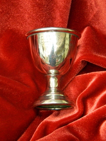
Trophy
Nellie Price entered Clarendon Presbyterian Ladies College in 1920. Daughter of Mr E H Price of 'Dumbarton' Sturt St W; sister of John L, Elvina Coltman & E Morris. Nell was President of the CPLC Old Collegians Association 1941-42 and Secretary 1955-57. She married Robert Smail, uncle of Andrew Smail (1954). Robert's father built the original Enderly house in Sturt St. This trophy provides a significant glimpse of both the nature and importance of sports amongst school students in the 1920s. There is a comprehensive report of the 1924 Sports Day in The Touchstone December 1924 pp.11-14Tiny silver egg cup and stem with rolled top edge and engraving on face of cupEngraved on cup:C.P.L.C. SPORTS / Snr Thread Needle / Snr Siamese / N.P. / 1924nellie-price, nell-smail, sports, 1924, clarendon-presbyterian-ladies-college -
 Kiewa Valley Historical Society
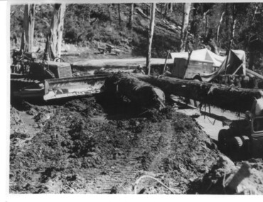
Photograph, logging at McKay Creek, Logging at McKay Creek, c1950's
This photograph was probably taken at the site of McKay Creek Power Station. Excavation of this site did not commence until 1951 but road access(a narrow track) was provided in 1948 and widened in 1954. The logs would have been milled for timber at the State Electricity Commission's mill at Howman's Gap and thus provided a much needed source of timber for construction of camps and houses as there was a general of shortage of this commodity. Because of trouble with landslides in this area, a decision was made to place the machine hall of the power station underground instead of on the surface. Restricted financial resources and the repositioning of the power station retarded construction activities and it was not completed until early 1961.. An excellent pictorial record of the general working conditions, type of machinery and vehicles in use in the 1950/s.Black and white photograph showing logging equipment, fallen logs.Handwritten on the back of the photograph "Logging at McKay Creek)logging, mckay creek, timber, machinery -
 Warrnambool and District Historical Society Inc.
Plate name, Tribute Egbert John Connell, C 1930
Doctor Egbert Connell worked as an Honorary Medical Officer at the Warrnambool General Hospital and benevolent Asylum from around 1901 and continued until his death on 4th April 1928 from pneumonia. he had a private practice at his house " Ambleside" in Koroit Street Warrnambool opposite the Baptist church. He was highly regarded as being kind and sympathetic towards his patients. His practice was subsequently bought by Dr A E Brauer another of Warrnambool's well known doctors. This glass plate accompanied a stain glass window which was once in the Warrnambool hospital. It was moved to the chapel at Flagstaff Hill. A link to one of Warrnambool's long serving doctors who was involved in the community and as such has social and historical importance.Green glass plate with black text and mounted on particle board and secured with metal clips.A tribute to Egbert John Connell MBBS who for 30 years rendered devoted and valuable service to this institution Obiit April 4th 1928 A Dwarrnambool, egbert connell, doctor egbert connell -
 Eltham District Historical Society Inc
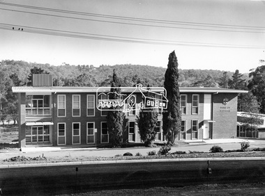
Photograph, Eltham Shire Office, shortly after duplication of Main Road, c.1968
Eltham Shire Council office built 1964 on the former site of Shillinglaw Cottage. In 1971 the offices were extended with a southern wing (to the left of the building) which housed the Eltham Library and planning offices. Taken shortly after widening of Main Road between Pitt Street and Elsa Court which was undertaken between February 1968 and August 1968. Image was most probably commissioned by Eltham Shire Council and taken by Hugh Fisher, photographer who operated from premises between Arthur and Dudely streets and was often contracted by the shire for official photographic work. The image was used in the August 1971 issue of Australian Municipal Journal This photo forms part of a collection of photographs gathered by the Shire of Eltham for their centenary project book,"Pioneers and Painters: 100 years of the Shire of Eltham" by Alan Marshall (1971). The collection of over 500 images is held in partnership between Eltham District Historical Society and Yarra Plenty Regional Library (Eltham Library) and is now formally known as the 'Shire of Eltham Pioneers Photograph Collection'. It is significant in being the first community sourced collection representing the places and people of the Shire's first one hundred years.Digital image and 120 format B&W negativesepp, shire of eltham pioneers photograph collection, eltham, main road, duplication, road widening, shillinglaw trees, local government -
 Ringwood and District Historical Society
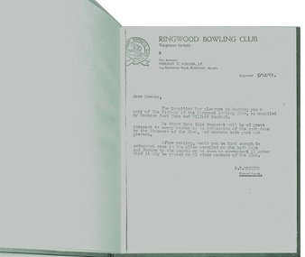
Book, Short History of Ringwood Bowling Club from 1929 -1961
The idea for a Bowling Club was started by Mr. Bert Cocks, the Manager of the State Savings Bank when he arrived in Ringwood in 1929 but it took two years before a suitable site and was found and in 1931 the club as formed. Ther were 57 foundation members. The President was Councillor Arthur Blood and W. Cox, Secretary. Ten months later the first Annual Report stated that " the green was ready for sowing, a Club House with a billiard table , donations of light fittings and furnishings by members and committee and a balance sheet showing assets over liabilities of £446,3,8." The book continues until 1961.It was compiled by Members Jack Knox and Wilfred Bamford.Plain green hard-covered book (untitled) with 25 typed pages. Letter to members inviting them to read the story and pass the book onto other members. Foreword by the President in 1961 -
 Flagstaff Hill Maritime Museum and Village
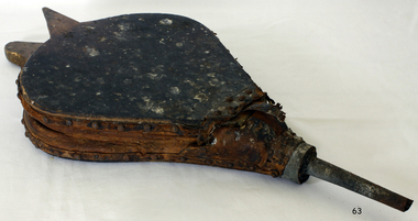
Domestic object - Bellows, Late 19th to Early 20th century
The fireplace was the main heating source for small houses before 1900, so a bellows to coax a flame from a dying fire was important. Early bellows were a bag made from the skin of a small animal and a piece of metal, usually brass, to direct the gust of air created by squeezing the bellows to fan the flames. Such bellows existed in China at least since the 5th century BC, when it was invented, and had reached Europe by the 16th century. In 240 BC, The ancient Greek inventor Ctesibius of Alexandria independently invented a double-action piston bellow used to lift water from one level to another.An item in domestic use in homes to coax a domestic fire into flame, the subject item was probably used in the late 19th to early 20th century home with open fireplaces as a domestic object. It gives a snapshot into how domestic heating was provided using wood or coal before electricity or gas came into regularly used.Bellows wood, leather and metal, parts Noneflagstaff hill, warrnambool, shipwrecked coast, flagstaff hill maritime museum, flagstaff hill maritime village, great ocean road, bellows, blacksmith bellows, fire bellows -
 Eltham District Historical Society Inc
Negative - Photograph, J. P. Lind, Hurst's Bridge, 1885
Looking northwest onto the first bridge at Hurstbridge, 1885. Timber bridge amid rural setting. Two horses graze in an open paddock in the foreground. A house is situated on a rise behind the bridge on a tree lined hill. The area of Hurstbridge was originally known as Hurst’s-bridge after the timber bridge built over the Diamond Creek near Hurst’s station in late 1881/early 1882 on the Hurstbridge-Arthurs Creek Road, Hurstbridge. It was built by John McDonald, of Arthur's Creek and was demolished and replaced in 1917 by a reinforced concrete arch bridge designed by John Monash. Cross Reference Photo No.(s): 1012/1013This photo forms part of a collection of photographs gathered by the Shire of Eltham for their centenary project book, "Pioneers and Painters: 100 years of the Shire of Eltham" by Alan Marshall (1971). The collection of over 500 images is held in partnership between Eltham District Historical Society and Yarra Plenty Regional Library (Eltham Library) and is now formally known as 'The Shire of Eltham Pioneers Photograph Collection.' It is significant in being the first community sourced collection representing the places and people of the Shire's first one hundred years.Digital image 4 x 5 inch B&W Negshire of eltham pioneers photograph collection, hurstbridge, bridge, diamond creek (river), diamond creek (creek), hurst's bridge -
 Glen Eira Historical Society
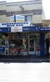
Photograph, Murrumbeena Road, 229, Murrumbeena, 2001
Originally labelled "Beauville Estate, Established 1936, Still Thriving 65 years on, 10th March 2001", the Beauville Estate Album contains colour photographs of houses in the Estate. They were taken around the time of the Beauville Estate’s 65th Heritage Celebration held on 10/03/2001 and donated to the Caulfield Historical Society shortly afterwards. Photographer unknown. From Glen Eira’s Heritage Management Plan by Andrew Ward (1996) Vol 2 p78: In Murrumbeena Road, the shops which form part of the estate are a simple cream brick row relieved by manganese bricks in bands across the upper storeys. City of Glen Eira’s Heritage Management Plan Vol 2 p79 (this is p84 of the pdf version) – HO12 Beauville Estate and environs, Murrumbeena: The Beauville Historic Area is important at the State level as the first large housing estate undertaken by the AV Jennings Construction Co, later Jennings Group Limited, Victoria’s largest home builder. It is important also as a very early estate development incorporating a range of features other than houses and including made roads, shops and recreation facilities. In this respect it was the forerunner of the comprehensively planned housing estate of the post war era. The estate is distinguished by its aesthetic values, as is the earlier and comparable Hillcrest Estate, which are formed by a combination of restrained diversity in house styles, with the exception of no. 30 in the emerging International style, and by a landscaped garden environment. Colour photograph of a section of a double storey, unpainted brick, commercial property containing shops at ground level all with awnings over the footpath. This specific property is a milk bar on street level with plate glass windows and door, colourful advertising and "229' in the top right section of the window. Shop signage says "MURREMBEENA MILK BAR". The upper storey brick residence features a large window, a flat roof and decorative two tone banded brickwork. MURREMBEENA (sic) MILK BAR / PK's / SANDWICH / BAR / MILK BAR & Sandwich Bar / 229 / SUB NEWSmurrumbeena, architectural styles, 1930's, inter war style, a.v. jennings, av jennings, jennings, beauville estate, murrumbeena road, milk bars, commercial establishments, flats, sir albert victor jennings, a v jennings construction co, beauville estate heritage area, glen eira city council, architectural features, jennings group limited, land subdivision, beauville historic area, shops, brick features, window displays, advertising signs, murrembeena (sic) milk bar -
 Glen Eira Historical Society
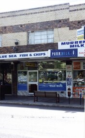
Photograph, Murrumbeena Road, 229A, Murrumbeena, 2001
Originally labelled "Beauville Estate, Established 1936, Still Thriving 65 years on, 10th March 2001", the Beauville Estate Album contains colour photographs of houses in the Estate. They were taken around the time of the Beauville Estate’s 65th Heritage Celebration held on 10/03/2001 and donated to the Caulfield Historical Society shortly afterwards. Photographer unknown. From Glen Eira’s Heritage Management Plan by Andrew Ward (1996) Vol 2 p78: In Murrumbeena Road, the shops which form part of the estate are a simple cream brick row relieved by manganese bricks in bands across the upper storeys.City of Glen Eira’s Heritage Management Plan Vol 2 p79 (this is p84 of the pdf version) – HO12 Beauville Estate and environs, Murrumbeena: The Beauville Historic Area is important at the State level as the first large housing estate undertaken by the AV Jennings Construction Co, later Jennings Group Limited, Victoria’s largest home builder. It is important also as a very early estate development incorporating a range of features other than houses and including made roads, shops and recreation facilities. In this respect it was the forerunner of the comprehensively planned housing estate of the post war era. The estate is distinguished by its aesthetic values, as is the earlier and comparable Hillcrest Estate, which are formed by a combination of restrained diversity in house styles, with the exception of no. 30 in the emerging International style, and by a landscaped garden environment. Colour photograph of a section of a double storey, unpainted brick, commercial property containing shops at ground level all with awnings over the footpath. This specific property is a fish and chip shop. The upper storey brick residence features a curtained window, a flat roof and decorative two tone bands of brickwork. It has a large street seat on the footpath out front.BLUE SEA FISH & CHIPS / TAKE AWAY FOODmurrumbeena, architectural styles, 1930's, inter war style, a.v. jennings, av jennings, jennings, beauville estate, murrumbeena road, milk bars, commercial establishments, flats, fish & chip shops, sir albert victor jennings, a v jennings construction co, beauville estate heritage area, glen eira city council, architectural features, jennings group limited, land subdivision, beauville historic area, brick features, restaurants -
Glen Eira Historical Society
Document - Mimosa Road, 91, Carnegie
This file contains 4 items: 1/7 pages of real estate advertisement, including colour and black-and-white exterior and interior photographs, downloaded from realestate.com.au, on 17/09/2007 prior to auction of the property on 06/10/2007. 2/A copy of a black-and-white photograph of exterior with Eric Darke, aged approximately 6 years, son of the first owners ca. 1927. 3/A copy of a colour photograph of exterior with later altered veranda, dated January 1982. 4/Research notes dated 30/05/2014, handwritten by Peta Darke, concerning the house and family at 91 Mimosa Road.carnegie, mimosa road, brick houses, koornang road, hocking stuart, staples mark, darke eric, darke frank mullis, darke edna joy, weeks edna, clothier peta, californian bungalows, wattle avenue, glen huntly, architectural styles, darke ruth marjorie, braden ruth marjorie, darke john cameron, darke frank macalister, darke richard alexander, darke alison joy -
 Federation University Historical Collection
Photograph - Photograph and Documents, Anne Beggs Sunter, Latta/Downing Family, Mount Helen
The Federation University Mt Helen Campus was once the farm of John Latta and his wife Elizabeth Ann Dean. The couple married in 1867 and had three children at the time of John Latta's death (Elizabeth Ann b.1870; Mary b.1873; John b.1875). Elizabeth later married George Downing, and had another six children. The house was situated in the vicinity of the current Administration and Caro Conference Centre buildings, surrounded by an orchard, and a well under the current Albert Coates Building (Union Building). The land was purchased by the Ballarat School of Mines for their tertiary division from the Stapleton family.Various items relating to the Federation University Mount Helen Campus, and the early settlers on the land, the Latta Family. .1) Parish Plan, including E. Latta, M. Fiscalini, R. Wynne, R. Nixon, J.U. Smith, J. Davis .2) Part of a 1930s ordinance map showing Ballarat, Buninyong and Greenhill .3) Contour Map with the first two Mt Helen Campus buildings included. .4) Drawing a a proposed campus plan .5) Latta Family negativemount helen campus, latta family, greenhill, e. latta, m. fiscalini, r. wynne, r. nixon, j.u. smith, j. davis, parish plan, john latta, elizabeth latta, george downing, elezabeth downing, green hill, pontresina, abraham baxter, g. dean, market gardens, jim downing, bob thornton, j. hateley, martin fanning, toll keeper, anne beggs sunter -
City of Moorabbin Historical Society (Operating the Box Cottage Museum)
Newsletter, CMHS Moorabbin Mirror Issue 11 July 2017, CMHS Moorabbin Mirror Newsletter Issue 11 July 2017, 2017
Topic; Notices for AGM July 23rd and Open House Melbourne 2017 July 29th a& 30th ; RHSV History week in October, Elster Creek; Clee Hill;Leonard.A. LePage; Cheltenham Church of Christ 160th; Pennydale Post Office; Cheltenham; Ross St & Smith St Bentleigh; This is Issue 11 of the Moorabbin Mirror produced by CMHS members Fran & Holger Bader , Geoffrey Paterson, in July 2017 The Moorabbin Mirror reflects the history and heritage of the former City of Moorabbin — derived from Mooroobin, ‘a resting place’ in the Bunurrung spoken language. In 1994, the City of Moorabbin was integrated into the Cities of Bayside, Glen Eira, Kingston and Monash This is Issue 11 of the Moorabbin Mirror, Newsletter of CMHS in July 2017A4 x 2 paper folded to A5 x 4pp printed on both sidesMoorabbin / Mirror / Newsletter City of Moorabbin Historical Society (CMHS) Inc . / operating Box Cottage Museum / July 2017 Issue 11moorabbin mirror, bader fran, bader holger, patterson geoffrey, cheltenham chhurch of christ, lepage a.l.; clee hill estate; elster creek, sir ross smith, aviators, moorabbin, bentleigh, cheltenham, brighton, market gardeners, early settlers -
City of Moorabbin Historical Society (Operating the Box Cottage Museum)
Newsletter, City of Moorabbin Historical Society No. 7 Vol. 5 October 1965, City of Moorabbin Historical Society No. 7 Vol. 5 October 1965, 1965
This is Newsletter No 7 Vol. 5 produced in October 1965 by Mr T. A. Sheehy CMHS for members and visitors The Aims of the CMHS are ‘to record the history of the City, and register something of the Australian Atmosphere, which the necessary speed-up in post-world-war two (WW11) immigration has caused to be lost; to produce a magazine at regular intervals, featuring the work of pioneers and the changing Australian scene; to work constantly with a long range view towards building a hall where records and exhibits can be housed’ (1961) Topics ; RHSV 1st Vic Historical Conference; MCC Mayor Cr. H Stevens; 'The Three McQueens conclude' This is Newsletter No. 7 Vol. 5 of the CMHS October 1965 CMHS obtained a Kingston City Council Community Grant 2016 for the digitization and preservation of these Original CMHS Newsletters commenced in 1961 1 x 21x L 26cm x W 21cm page 1 printed both sides CITY OF MOORABBIN HISTORICAL SOCIETY / AFFILIATED WITH THE ROYAL HISTORICAL SOCIETY OF / VICTORIA AND THE CHELTENHAM ARTS AND CRAFTS SOCIETY/ President Mr R. Ashley….Editor of Newsletter Mr T.A.Sheehy Secretary Mrs F.Neville / VOLUME 5 No.7 NEWSLETTER OCTOBER 1965city of moorabbin historical society 1961, sheehy t.a., newsletters, neville f, ashley r, moorabbin city council, rhsv, stevens h cr mayor, mcqueen m, -
 City of Moorabbin Historical Society (Operating the Box Cottage Museum)
Photograph, Black & White, 'Oak Bank' later 'Whitehouse' Ann St. McKinnon c1920, c1960
'Oak Bank ' , in Ann Street McKinnon, was originally owned by Mr Robert Smith. The house was later renamed 'The Whitehouse' and was still in use as a General Hospital in the 1950's, known as the Ann Street Hospital.. This small hospital handled some Surgery, Midwifery and general Medical cases from the fast growing Bentleigh / McKinnon area. As time progressed the Hospital became too small, and was unable to meet new medical standards When Moorabbin Community Hospital opened c1974 in Centre Road East Bentleigh, the Ann St Hospital closed. The Moorabbin Hospital is now a campus of Monash Medical Centre Clayton. 'The Whitehouse' was used as a general Hospital for the residents of McKinnon, Bentleigh, and Ormond for many years during the 20thC.Colour photograph showing Mrs John Marriott ( nee Ann Smith) , her son Fred Marriott standing outside 'The Whitehouse' undated ? c1960Back ; Handwritten informationoakbank house mckinnon, whitehouse mckinnon, ann street general hospital, moorabbin community hospital, monash hospital clayton, smith robert, lees seedling growers ltd. thomas street mckinnon,mith j l; smith mary ann, stanley helen, smith vic, chaff cutter, horse drawn carts, toll gates brighton, motor cars 1900, steam engines, early settlers, bentleigh, mckinnon, parish of moorabbin, city of moorabbin, county of bourke, moorabbin roads board, shire of moorabbin, henry dendy's special survey 1841, were j.b.; bent thomas, o'shannassy john, king richard, charman stephen, highett william, ormond francis, maynard dennis, market gardeners, vineyards, orchards -
 Port Melbourne Historical & Preservation Society
Photograph - Launch of History of a Street Precinct, 25 Sep
In 2005, members of the PMH&PS undertook a study of the residents of the houses in a Port Melbourne street precinct from the 1880s to 1960. The area is bounded by Evans Street, the E side of Bridge Street, S side of Williamstown Road, Farrell Street both the E & W sides plus the section of Ross Street between Farrell and Bridge and the part of Derham Street between Farrell and Bridge. The resulting map and an interactive CD won the Best Community Research, Registers & Records project at the 2007 Victorian Community History Awards. The project was launched on the railway reserve near the corner of Evans & Farrell streets. Co-author Graham BRIDE.Co-author, Graham Bride, at the launch of the History of a Street Precinct25/9/05 Graham Bridehistory of a street precinct, graham bride -
Tatura Irrigation & Wartime Camps Museum
Photographs, Alexander Stewart who lived at Gowrie Park
GOWRIE PARK- Gowrie Park Road, Tatura.|Alexander and Georgina Stewart sailed in 1859 from Mochrum, Scotland, arriving in Corio Bay. In 1872-73 they came to Tatura and selected near the town, being one of the early selectors. The place was called Gowrie Park, still known by that name, and still in use as a dairy farm.|Before the Presbyterian Church was built in Tatura, all the services were held at Gowrie Park. The old dairy for keeping milk, cream and butter is still there today. Only two families have owned the property since the 1870®s, and the house has been beautifully renovated and extended.Photo 1: 15 x 11 cms. Photo 2: 10 x 6 cms. -
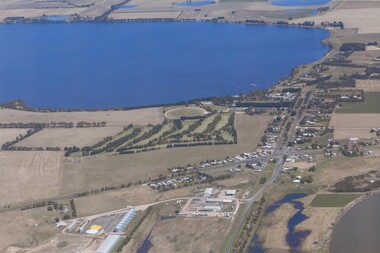 Lake Bolac & District Historical Society
Colour photograph, Aerial view of Lake Bolac and village. After the rain, 2010
Aerial view of Lake Bolac after the drought had broken in late 2010. The fresh-water lake is now full, as are the wetlands. Note the edge of the salt-lake in the bottom right, the Industrial Estate bottom left and centre, the golf course, the current footy oval, Bowling Club, tennis courts and swimming pool with the P-12 College through the trees on the bank of the lake. An Archaeologist might be able to discern the original footy oval bottom centre, built on what was once the town Common (below the industrial buildings),and the second oval (above the salt lake.) The houses are spreading along the west bank of the lake beyond the school.lake bolac, 2010, village, fresh-water lake, salt lake, golf, tennis, bowling, swimming, college, -
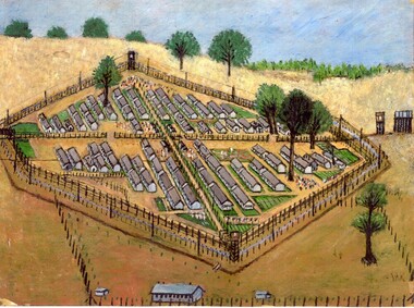 Tatura Irrigation & Wartime Camps Museum
Sketch, Camp 3
There were 7 camps in the area during World War II which held about 4,000-8,000 people at any one time. 3 camps housed Prisoners Of War who were enemy servicemen captured in various theatres of war around the world and transported to Australia for the duration of the war. The remaining 4 camps held Internees who were civilians living in Australia or other Allied territories and countries at the outbreak of war and were deemed to be a security risk because of their nationality. The camps were situated in the Goulburn Valley as food was plentiful here and there was a good supply of water from the Waranga Basin.A coloured sketch showing all the compounds at Tatura War and Internment Camp.internment, ww2, world war two, tatura, goulburn valley, war camps, prisoner of war, prisoner of war camps -
 Stawell Historical Society Inc
Photograph, Wooden Home at no.1 Seaby Street -- Coloured photo
Home in Seaby Street no.1 next to railway line. Built by Luke Kinsella about c 1870. Photo taken March 1992 about time of sale. A series of nine coloured photos in Album 8. p 37-42 of the Seaby house and interior. Photos in album 8 show 3 different views of the side of the building. One of the wood paneling in the entrance hall. Also 3 photos of the mantlepieces and cast iron grates in the fireplace. Luke Kinsella, brother to Thomas Kinsella's (part owner of Magdala cum Moonlight mine). Thomas was the eldest of the boys then Luke and John Kinsella the youngest. Home in Seaby Street no.1 next to railway line. Built by Luke Kinsella about c 1870. Colour photograph. Series of 9 photos in Album 8. p37-42.stawell dwellings -
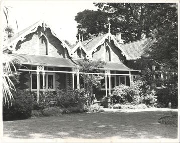
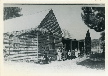 Mt Dandenong & District Historical Society Inc.
Photograph, "Shiloah" 1913
'Shiloah' was the home of Isaac Jeeves the younger - son of Isaac Jeeves the Valley Pioneer and brother of Ellis Jeeves. Isaac built this house himself using local timber he cut and split. It was ready for his marriage to Selina Leach of Bayswater in 1886. ‘Shiloah' was enlarged to take guests in the early 1900s. It was situated close to a beautiful fern gully and Isaac and his family capitalised on this by setting out walking tracks through the ferns. They charged 1/- to walk through and this included afternoon tea in a garden setting. ‘Shiloah’ was a popular tourist attraction but the making of the Olinda Creek Road destroyed the fern gullies and, by the 1930s, it was all finished.Black and white photograph of wooden structure with two wings and a central verandah. Eight adults sitting or standing at the front.Handwritten on back by John Lundy-Clarke "Shiloah" 1913.isaac jeeves, isaac jeeves the younger, ellis jeeves, shiloah, guest house, guesthouse, selina leach, selina jeeves, olinda creek road -
 Mt Dandenong & District Historical Society Inc.
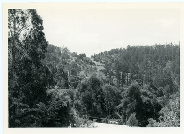
Photograph, View From Doughty's Road 1974
John Lundy-Clarke grew up in the Kalorama/Mt Dandenong area and later in life (1972-74) began to write a comprehensive history of the area working from an original settlement map in an effort to cover all areas. This photograph shows approximately the same area as photograph number KAL0193 but is taken 60 years later. The trees have grown much taller and the buildings changed. On the site of the Paynter house 'Iona' there is now the 'Yosemite' (Villa Toscana) accommodation. The pavilion in the centre of the photo is the site of 'Kalorama', home of early pioneer Isaac Jeeves. The photograph is taken looking up towards The Gap (FiveWays).Black and white photograph showing a forested area with clear sites. Roofs of buildings can be clearly seen. Handwritten inscription on reverse by John Lundy-ClarkeView from near Doughty’s Rd looking north up valley to Kalorama Gap in Jan 1973. Tiny roof in centre is pavilion on site of “Kalorama”. Long roof to its left is Yosemite Motel on site of “Iona”.paynter, kalorama, iona, yosemite, villa toscana, five ways, the gap -
 Mt Dandenong & District Historical Society Inc.
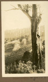
Photograph
The W. JEEVES in the inscription would be Walter Jeeves. Walter Jeeves was the second son of Ellis Jeeves and the grandson Of Isaac the Pioneer. Walter had been given the house 'Kalorama' and twenty acres of land. He turned this into a commercial garden. Firstly vegetables then later flowers and shrubs. The land was sloping. Walter married Dorothy Hayes and had four daughters. When Walter died in 1960 the property was put up for sale and it was eventually purchased for the State through the efforts of the Save the Dandenongs League. This photograph is from the album of Ivy May Child so would have been taken between 1927 - 1932.Sepia coloured photograh with a tall gum tree in the foreground and a large homestead in the centre of the photograph surrounded by orchards.Written below the photograph in the album: W. JEEVESwalter jeeves, dorothy hayes, save the dandenongs league, kalorama -
 Melbourne Legacy
Pamphlet - Document, brochure, The Legacy Boy - worthy son of a worthy father, 1960
A brochure for Legacy Albury explaining Legacy's work and providing information on how to donate. Headings in the brochure included: Whom does Legacy help? What kind of help does Legacy provide? How many dependants is Legacy actively helping in Victoria? What does Legacy spend in this State in its work? How are these funds provided? Why it necessary to provide this degree of help, when there is a generous Repatriation Act? What is Legacy's aim? Address given is ANZAC House, Dean St, Albury NSW. Reprint 1960. Also a leaflet using the same boy's photo, format changed to fit a single page without folding.A record of how Legacy portrayed itself to the wider community.00408.1 One page white paper, folded in half. Black and white photograph and printed text. 00408.2 One page white paper. Black and white photograph and printed text.marketing, legacy promotion, albury, objectives -
 Kew Historical Society Inc
Photograph, 'Roseneath', Pakington Street, c. 1960
Roseneath is an A-listed house in the City of Boroondara. It was built between 1858 and 1860. This work forms part of the collection assembled by the historian Dorothy Rogers, that was donated to the Kew Historical Society by her son John Rogers in 2015. The manuscripts, photographs, maps, and documents were sourced by her from both family and local collections or produced as references for her print publications. Many were directly used by Rogers in writing ‘Lovely Old Homes of Kew’ (1961) and 'A History of Kew' (1973), or the numerous articles on local history that she produced for suburban newspapers. Most of the photographs in the collection include detailed annotations in her hand.The Rogers Collection provides a comprehensive insight into the working habits of a historian in the 1960s and 1970s. Together it forms the largest privately-donated collection within the archives of the Kew Historical Society.Facade of Roseneath, Pakington Street, Kew. Roseneath, 37 Pakington St., Kew. Built between 1858-1860. E.J. Dunns home. & dogs all soldroseneath, pakington street, kew, dorothy rogers -
 Friends of Westgarthtown
Painting, John Borrack, Last Days Ziebells "The Pines" Thomastown
Painted from the home (or front) paddock which ran south to the creek. The paddock was used for the cultivation of lucerne and maize crops in the lower regions while closer to the house where Ainwick Crescent is now situated, it was a burgeoning market garden for the cultivation of all varieties of vegetables. The large pines beyond, sheltered the farmyard on the west of Gardenia Road. That complex can be partly glimpsed on the left of the painting. This is a directly painted watercolour relying on the use of white paper and transparencies to impart a feeling of morning light. The figure is the artist's mother for whom the picture was painted. Provenance: Augusta Borrack (nee Ziebell) Collection, John Borrack CollectionWatercolour painting, depicting Ziebell's Farmhouse from the south (Thomastown and Mernda). Painting is mounted in a gold frame with cream board.Artist signature: John Borrack; Last Days at Ziebells "The Pines" Thomastown, 'Pro mea matre hanc picturan feci (In Memoria)'illustrations, watercolours, john borrack, ziebell, watercolour, painting -
 Surrey Hills Historical Society Collection
Painting, Muriel Pornitz (Pornett), "The old quarry" by Muriel Pornitz, 1927
The waterbody was the site of a quarry that existed between Grovedale Road and James Street, Surrey Hills on land owned by J B Maling (senior). Clay from it was used to make bricks for local houses. The quarry became a hazard and after several drownings was filled in. The Grovedale Park now occupies the site. Muriel Hedwig Lucy Pornitz, also known as Muriel Pornett, lived locally. She was born in Melbourne in 1894 and studied at the South Australian School of Arts & Crafts in 1911 under James Ashton and Fred Britton, and at the Australian School of Etching in Sydney. She was also an illustrator and cartoonist. She died in 1982.A small oil painting on canvas board in a dark wood frame of a water body with a clay bank behind and 2 trees above the bank. Lower front right hand corner: "AUST. M P 1927" On the rear upper edge, in ink on badly degraded brown paper backing: " "The Old Quarry" Surrey Hills, Melb." / [Second line of writing is illegible.] A label is stuck to the middle section of the paper backing. It indicates that the painting was framed by Toska Art Studio (N. Cl Colliver, Proprietor) of wyndham Street, Shepparton. Lower rear edge, in ink on badly degraded brown paper backing: "by / Muriel ...... / "Darnok", / 22 Grovedale Rd / Surrey Hills, Melb" painting, grovedale road quarry, quarry, grovedale road park, john butler maling (snr), surrey hills, muriel pornitz, muriel pornett