Showing 963 items matching " brighton road"
-
 Glen Eira Historical Society
Document - KAMBROOK ROAD, 46, CAULFIELD NORTH
A copy of a one page typed report by Hilary Bullock and Rosalind Landells of the Brighton Historical Society, dated 14/10/1995, with handwritten notes about this property. It covers the owners of this address from 1918 to 1994 and a short history of the origins of Caulfield Racecourse and land development by 1917. It also mentions the first meeting of the Caulfield Amateur Turf Club in 1859.caulfield north, kambrook road, caulfield cup, caulfield racecourse, racecourses, caulfield amateur turf club, 'kambrook', payne john, balaclava road, swan william h, urquhard john, wenn john, reddon george, may phillip g, griffin g mrs, newton g t (horse trainer), bullock hilary, landells rosalind, bick david, foote henry (surveyor), caulfield roads board, glen eira road, land subdivision -
Glen Eira Historical Society
Document - Kooyong Road, 110, Caulfield North
Copy of typed letter 27/05/1989 from Brighton Historical Society giving details of history/owners/tenants of 110 Kooyong Road, Caulfield North from 1840 to 1985. Accompanied by handwritten working notes naming owners/tenants of property 110 Kooyong Road, North Caulfield from 1936 to 1985. House was built in 1936.kooyong road, rosemont farm, howitt godfrey dr, settlers, caulfield north, howitt alfred, henderson garnet w., henderson m.m. miss, haskin joseph, anstee w.e., holst edward, bullock hilary, landells rosalind, land subdivision -
Glen Eira Historical Society
Document - Jasper Road, 321, Ormond
A copy of a two page research report on 321 Jasper Road, Ormond by Hilary Bullocks and Rosalind Landells of the Brighton Historical Society, dated 08/11/1996. The report provides a brief history of the property and its occupancy. The file also includes one page of their handwritten, undated working notes.bick david, landells rosalind, bullocks hilary, bentleigh, ormond, jasper road, glengarry villa, raveloe, moorabbin, hallinan family, garrett minnie, hallinan frank, ellin albert, hannaford harry j, chatts julius, o’loughlin kath, o'loughlan kath, o’loughlin e, o'loughlan e mrs, martin albert v, perry c v, phelan leo a, perry albert e, jones robert h, jackson a, schools -
Glen Eira Historical Society
Document - Classic Retirement Village, Brighton
Four documents about the history of this site pre Classic Retirement Village: 1/A copy of a description of the sale process of the Gascor site, cnr Nepean Highway and Thomas Street, to Becton Corporation in 1997 And 1998. Printed on 31/07/2010 from the Victorian Auditor General’s Department website with aerial photograph 2/A copy of page one of the Gleneira Planning Scheme dated 19/01/2006 which mentions the Gascor site. 3/Research note by Andrew Frederick dated August 2010 listing occupiers of the site in the 1960 and the 1970 Sands and Mc Dougall Directories. 4/Research note by Claire Barton dated May 2010 containing Ian Swan’s recollections of working at Daylesford Worsted Woollen, occupier of the site, in the 1960s.thomas street, brewer road, bentleigh, gascor, becton corporation pty ltd, virginia park, gas and fuel, hughesdale dairy, east boundary road, moorabin, east bentleigh, hooblerstone, clairmont avenue, glen eira, daylesford centenary woollen and worsted mills pty ltd., nepean highway, f and j industries australia plastic and rubber division., swan ian, korman stanley, mills, wool industry, weaving mills, textile factories, textile manufacturing, manufacturing industry -
Glen Eira Historical Society
Document - Liscard St, 9, Elsternwick
A typed copy of a one-page report dated 16 May 1988 by H. Bullock and Rosalind Landells of Brighton Historical Society regarding the history and occupany of 9 Liscard Street, Elsternwick from 1888-1974. An undated hand-written note of the same information is included.liscard street, glen eira road, elsternwick, doyle estelle mrs, trew william tracey, cobbledick f.j. mrs, larsen rasmur j., johnson e. mrs, larsen bertha mrs, larsen roy, corkhill, depression 1890s -
Glen Eira Historical Society
Plan - Nettalie
... of Moorabbin Caulfield Road District Melbourne and Brighton Railway ...An A4 photocopy of the 'Plan of the Caulfield Road District' dated 1867. This plan shows the location of the properties owned by A Shaw and Blundell on Balaclava and Orrong Roads where Nettalie is situated. The plan includes all the landowners listed where their property was, the street names and other landmarks of 1867 including railways, hotels and reserves.caulfield, caulfield north, elsternwick, st kilda east, parish of prahran, parish of moorabbin, caulfield road district, melbourne and brighton railway, rosstown railway, elsternwick railway station, caulfield railway station, rosstown railway station, murrumbeena railway station, baptist church, paddy’s swamp reserve, cemetery reserve, leman swamp reserve, caulfield racecourse reserve, brighton cemetery, the vine caulfield hotel, the tam o’shanter hotel, melbourne hunt hotel, royal hotel, hotham street, horne street, nepean highway, north road, orrong road, dandenong road, princes highway, kooyong road, alma road, inkerman road, balaclava road, glen eira road, glen huntly road, hawthorn road, cemetery road, bambra road, redan road, kambrook road, neerim road, booran road, racecourse road, grange road, koornang road, murrumbeena road, crosbie road, kangaroo road, poath road, ford w, lempriere, cople j, riddell j c, manifold j, testar t, billing r h, semple, blundell, shaw a, butchart g, stephen j w, stephen g sir, hart j, duncan g, blackie r, stephen f, mccombie t, woollaston h, higgins j, lloyd j c, daish j, mcleod j, hughes d, wilson a, jamieson g, webb g h, renwick s, pennington h, dunn j, kirkpatrick w, ricketson w, toad a, sayce j, watts t, widgery, store, guess j, anketell j, clack j, sissen w, clayton g, dickson d, bevan j, hart t, anderson j, hart mrs, webb h, masters s, waghorn j, hemming c, hiam c, farquhar w, newing t, payne t, cooper r, snipe s, chambers j, forster w, summers r, harriman b, warrick, o’connell, long j, peck r, cochrane c, murray ross w, evans c, kennedy j, maclean n, forster, lyall w, dean j, newton h, looker w, baker c, johnston, crosbie j, kerr, jones, parr, nelson c, montgomery l, parsons w, james j c, sibon c, smith sydney w, plans, maps, land subdivisions, land use, settlements, roads and streets, hotels, churches, police stations, post offices, land surveys, railway stations, railways, schoolhouses, commerce, clergy residences, official buildings, local government, road districts -
Glen Eira Historical Society
Letter - Orrong Road, 49, Elsternwick
... with valuations of 49 Orrong Road and two Brighton properties. Sent... 19/04/1963 with valuations of 49 Orrong Road and two Brighton ...A black and white photocopied letter dated 19/04/1963 with valuations of 49 Orrong Road and two Brighton properties. Sent by John Pullman from Gemmel Tuckett and Co. to W.V.Scott.gemmel tuckett and co., scott w.v., land values, orrong road, elsternwick, pullman john, overland investments, hamilton h.c.a. -
Glen Eira Historical Society
Document - Orrong Road, 225/225A, St. Kilda East
A history of the creation and ownership of 225/225A Orrong Road Caulfield researched by H. Bullock and Rosalind Landells and dated to 25/07/1988. Includes handwritten notes regarding the same subject.orrong road, st. kilda east, lempriere william george, greenmeadows, clarke william, shire of caulfield, councillors, caulfield city, caulfield, bullock h., landells rosalind, brighton historical society, land subdivision, spence david, david street, flats, cooke jordan, cooke w. -
Glen Eira Historical Society
Document - FAIRFIELD HALL, NORTH ROAD, 225, CAULFIELD SOUTH
A two page document, dated 31/05/1981, from the Brighton Historical Society, written by Rosalind Landells, about Fairfield Hall. The document provides a brief history on Fairfield Hall, describes the surrounding area, provides details of buildings architectural features, and gives information about the house’s occupants and additional details about the occupants the Younger family.fairfield hall, north road, caulfield, caulfield south, elsternwick station, gardenvale station, lantana street, begonia street, magnolia street, younger family, younger alex, norris william, landells rosalind, leadlights, curwen frederick w, hawthorn black brick, architectural features, tuck pointing, tessellated tiles, verandah, towers, rudd e w, hurley, knight c p, manala, wall harry, warrein road, wall hounsell, younger a m, younger john, kenya, younger a m mrs, campbell h a mrs, campbell hugh, younger jeanne, gardenvale, younger avenue, younger’s avenue, fairfield grove -
Glen Eira Historical Society
Book - Dalkeith
... Brighton cemetery Cemeteries Grange Road Ripponlea McConchie David ...A 69 page bound history of the McConchie family who occupied Dalkeith. Mention is also made of the Lade family who had associations with the McConchie family and Dalkeith. The book includes numerous stories and memories concerning places, residents and locals from areas where the McConchie and Lade families holidayed and lived. The book also includes copies of marriage certificates of the family, family photographs, birth certificates, newspaper articles relating to the McConchie family, relevant correspondence, a hand drawn plan of the Dalkeith property, school records and some other relevant extracts. The file also includes a one page hand drawn family tree and one page of handwritten research notes.mcconchie william, dick agnes, elsternwick, dalkeith, kooyong road, caulfield, davis street, bootmakers, staniland grove, saddleries, glenhuntly road, orrong road, carre street, charles street, hopetoun street, mcconchie harry, mcconchie alan, mcconchie don, grocers, caulfield citizen band, st johns presbyterian church, hawthorn road, caulfield methodist church, crocket mr, mcconchie janet, mcconchie agnes, mcconchie annie, lade family, lade ruth, lade marjorie, mcconchie thomas, blacksmiths, murray street, weatherboard buildings, st mary’s, glen eira road, bands, hopetoun gardens, elsternwick station, hansom cabs, tin lizzie vans, postal services, brighton cemetery, cemeteries, grange road, ripponlea, mcconchie david, caulfield state school -
Glen Eira Historical Society
Document - Elizabeth Street, 9, Elsternwick
A copy of a one page typed report by the Brighton Historical Society, dated 15/01/1988, providing details of the occupancy of 9 Elizabeth Street, Elsternwick, and some commentary on the property Ripponlea and its owner Thomas Bent. The file also includes one page of unattributed and undated handwritten working notes.elizabeth street, elsternwick, sharp effie, sharp a, komaizy a, bent tommy, bent elizabeth, bent thomas, bent thomas mrs, ripponlea, bent street, world war 1914-1918, local officials, historical buildings, heads of state, councillors, gordon street, glen eira road, bullock hilary, landells rosalind, brighton historical society, bleazby elizabeth -
Glen Eira Historical Society
Document - Shoobra Road, 19, Elsternwick, 'Ettrick'
Two copies of a one page chronological report prepared by the Brighton Historical Society, dated 29/02/1988, about the occupiers of the property 'Ettrick', located at 19 Shoobra Road, Elsternwick. The report also includes a brief history of the property, a description of the property’s roof and information on the origins of the property’s name. The file also includes one page of handwritten undated and unattributed working notes.ettrick', carlingford street, brown robert s, turnbull james a, peters j, slate tiles, ross william a, ross elizabeth a, pollard a k, shoobra road, elsternwick -
Glen Eira Historical Society
Document - GARDENVALE ROAD, 77, GARDENVALE
This file contains research by the Brighton Historical Society into this property: 1/A photocopy of a typed document describing the history of the property at 77 Gardenvale Road, with a brief history of Gardenvale, including the impact of the building of Gardenvale Station in 1906 and the railway underpass in 1927. Before the station was built, the area had many market gardens, many of which were sub-divided after the station was built. Includes a list of past owners/residents of 77 Gardenvale Road (previously number 49). 2/Also includes a carbon copy of this document which is faded. 3/Handwritten notes covering mostly same information. By Hilary Bullock and Rosalind Landells of the Birghton Historical Society, printed on 22 July, 1987.market gardens, railway lines, gardenvale station, gardenvale road, o’neill family, chinese community, lempriere’s paddock, martin street, judd frederick, drayton me, agg george, agg family, agg mary, agg winifred, agg fanny, railway stations, macaulay misses, gardenvale -
Glen Eira Historical Society
Document - Glen Huntly Road, 575, Elsternwick
A copy of a one page typed report by the Brighton Historical Society, dated 02/05/1988, providing a brief history of the property at 575 Glen Huntly Road, Elsternwick and a list of the house’s occupants between 1912 to 1974. The file also includes one page of undated and unattributed handwritten working notes.glen huntly road, glenhuntly road, elsternwick, goodridge thomas l, pennifold frank, chenery arthur b, chenery h b, wolfenden a o, ryan kath, mcdonald norah, mckellin r, poelte s -
Glen Eira Historical Society
Document - Allison Road, 60, Elsternwick
Typed carbon copy of correspondence dated 15th January 1988 from Brighton Historical Society to Noel Jones Real Estate Pty Ltd Elsternwick detailing the history of the property owners of 60 Allison St Elsternwick from 1907 to 1974 -
Glen Eira Historical Society
Document - Balaclava Road, 91, Caulfield North, 'Miami'
Typed notes on the history and past owners of the house 'Miami', Balaclava Road, 91, Caulfield North, by Hilary Bullock and Rosalind Landells of the Brighton Historical Society, dated 9/09/1988. The file also includes is an additional handwritten summary of the information.miami, balaclava road, otira road, bendigo road, caulfield north, dixson francis, mcharg gerald, dean c r, walker a g, bullock hilary, landells rosalind -
Glen Eira Historical Society
Document - Cavers Carre
Three articles about Cavers Carre. Handwritten document giving details of the location of the house. Built c.1866 and demolished prior to 1905 when the block was subdivided. No details of the house. Two plans of Gardenvale and Riddell Estate dated 29/11/1884 and unknown from State Library Victoria records.gardenvale estate, glen huntly road, riddell estate, melbourne and brighton railway, mcmillan street, orrong road, archibald street, rowan street, hamilton street, downshire road, shoobra road, madden walter, tuxen august, fraser and co., surveyors, muntz and muntz, cavers carre, elsternwick, stanley street, carre street, railway cresent, riddell parade, riddell john carre, land subdivisions -
 Eltham District Historical Society Inc
Document, Russell Yeoman, Tour of Historic Buildings and Locations, 1978
Self guided heritage tour information produced by the Shire of Eltham Historical Society for 1978 Eltham Community Festival of 36 locations each numbered on accompanying map. Locations and detail provided current to 1978: 1. ELTHAM SHOPPING CENTRE Whilst very little remains in the centre of historical importance, this area has interest as the "village" which developed over many years following the opening of the railway from Melbourne in 1902. Previously the shopping centre had been spread out over a long length of Main Road to the south. Shops have been continuously demolished or remodelled and the majority of buildings date from the 1950's or later. The recently erected Post Office replaced the "old" Post Office opened on the same site only in 1958. 2. WOOLWORTHS ELTHAM VILLAGE Part of the site of this modern shopping development was occupied by the former Eltham Shire Offices and Hall. The hall was paid for by public subscription whilst the Council raised a loan for the offices. The combined building was opened in 1941. It served as office and Council meeting place until 1965 and as the hall until its demolition in 1970. 3. ELTHAM WAR MEMORIAL The complex of buildings adjoining the present Shire Offices were financed by public subscription as a Memorial following World War II. Their construction and for many years their operation was organised by the now disbanded Eltham War Memorial Committee. The original buildings were the; Infant Welfare Centre, Children’s Library (now War Memorial Hall and Dental Clinic) and Kindergarten. In later years the Elderly Citizens Club was built at the rear. 4. ELTHAM SHIRE OFFICES These offices were opened in 1965 and extended in 1971 to provide additional office accommodation and the Eltham Library. They represent the last of a long line of offices and meeting places of the Eltham Shire Council and its predecessor the Eltham District Road Board. The building occupies the former site of Shillinglaw Cottage. The three tall cypress trees which stood in front of the Cottage have been retained as a feature of the office surrounds. 5. OUR LADY'S CHURCH AND SCHOOL The Catholic Church and School complex opposite the Shires Offices shows a number of stages in the development of Eltham township. The recently constructed church adjoins its predecessor (now the parish centre). Many years ago the Catholic Church was located opposite Wingrove Park and the present central site follows the northerly drift of the township. 6. SHILLINGLAW COTTAGE The Cottage was built in 1859 by George Stebbing, a local builder who was responsible for a number of other prominent buildings in the area. Its removal from the site of the Shire Offices and re-erection on the present site was financed by public subscription. It is built of handmade bricks laid in Flemish Bond with an unusual design featuring burnt "leader" bricks over the whole facade. The Cottage is occupied by Eltham Fleececrafts and will be open during the Festival and at other times during weekends. It is classified by the National Trust. 7. RAILWAY BRIDGE The timber trestle bridge over the Diamond Creek was built in 1901. Whilst all of its timbers have been replaced at various times over the years the only change to its character has been the addition of pylons and wiring for electric trains in 1923. It is one of very few similar bridges remaining in the metropolitan area. In 1976 a proposal to replace the bridge with an earth embankment and large culvert pipes was abandoned following community protests. The bridge, however, remains under threat because of the necessity for future deuplication of the railway line. 8. ELTHAM CENTPAL PARK The area between the railway and the creek has for many years been used as a park which included Eltham' s main football oval. The access road, Panther Place is named after Eltham's team playing in the Diamond Valley League. In recent years a large area extending to Bridge Street and locally known as the Town Park has been landscaped and added to the area. The excellent blending of the park with the natural landscape of the creek valley has earned a National Trust Landscape Classification. 9. OLD BAKERY On the southern corner of York Street and Main Road is an old house with a shop front which was for many years the local baker's shop. The brick bakery at the rear is of somewhat later vintage than the house. 10. BRIDGE STREET CUTTING Before reconstruction of Main Road this intersection had deep cutting embankments on all four corners, forming a distinctive feature of the entrance to Eltham. Roadworks and private development have levelled the land on the low side of the road. A memorial to the Eltham soldiers of World War I which was located at the north-western corner is now situated at the Eltham R.S.L. 11. HILLTOP MILK BAR For many years this was the site of the Eltham Post Office under the control of the Hunniford family and later their descendants the Burgoynes. It was transferred to this site in 1855, although at that time the building apparently fronted Bridge Str e et. The site contained Eltham's first telephone exchange. The post office was relocated in 1954 but the shop was operated until recently by the Burgoyne family who still own the surrounding land. 12. UNITING CHURCH and former C.B.A. BANK The former Methodist Church was built in 1880 by George Stebbing. The Sunday School extension was built in 1929 and there have been more recent extensions. The adjoining opportunity shop was built as a bank in 1874 and purchased by the Methodist Church in 1954. 13. R.S.L. HALL, TELEPHONE EXCHANGE These relatively recent buildings occupy the site of a row of shops forming part of the early ribbon of business development along Main Road. In front of the R.S.L. building is the World War I Memorial relocated from the corner of Bridge Street and Main Road. 14. ELTHAM COMMUNITY CENTRE Australia's first mudbrick "community building" was opened in April this year. Part of the site of the building was purchased in 1856 by Henry Dendy (of Brighton fame). At the rear of the land near the creek was a steam flour mill whilst Dendy's house was at the Main Road frontage of the land. His purchase totalled about 2 Ha (5 acres) and included land on the opposite side of Maria Street (Main Road). Dendy became a prominent member of the Eltham community and served one term as President of the Eltham District Road Board. In 1867 Dendy sold his land and business to William Ford of Malmsbury and shifted to Walhalla. The avenue of trees leading past the Community Centre to the creek may well have bordered the track to the mill. 15. ELTHAM HOTEL The original part of this hotel was built in 1927 following the burning of the former Watson's Eltham Hotel on the same site. The car park on the opposite side of Main Road was also the site of a hotel variously known over the years as; the Fountain of Friendship, the Fountain and the Evelyn Arms. As the Fountain of Friendship it was the first meeting place of the Eltham District Road Board in 1856. 16. ST. MARGARET'S CHURCH, PITT STREET In 1860 Henry Dendy was appointed Chairman of a committee to establish a church of England in Eltham. He donated part of his land in Pitt Street and in 1861 the church was opened. It was built by George Stebbing and remains in a well preserved state today. Th adjoining old vicarage is now named Dendy Hou se. A new mudbrick church hall is under construction on the site. The church and Dendy House are now listed on the Register of Historic Buildings. 17. NO. 86 PITT STREET Cottage built by George Stebbing and believed to be his home for some years in the 1850s. 18. LIVING AND LEARNING CENTRE The house was built in the 1850s with the kitchen at the front being added about 40 years later. By the creek below the house a number of early Eltham industries were located. These included a tannery and a brewery. 19. ELTHAM COURT HOUSE A Court of Petty Sessions was established in Eltham in 1858 and the present building dates from 1860. It is the oldest public building remaining in Eltham. In its early days the building was used as the meeting place and office of the Eltham District Road Board and as an overflow classroom for the local school. The Court House has been classified by the National Trust. The citation states that it is an example of the simple form of early brick Court House with gabled roof and porch. 20. LANDS DEPARTMENT OFFICE This building is the former police station and is probably of about the same age as the Court House. The lockup at the rear has been demolished but the old stables remain as garages. A licence was first granted for a police station at Eltham in 1856. 21. JARROLD COTTAGE The old Cottage opposite Dalton Street was formerly owned by the Jarrold family. Early records indicate that this was the building leased from the Jarrolds as a temporary police station prior to construction of the building on the corner of Brougham Street. The small building on the corner of the property was used as a boot repairer's shop. The elevated studio at the rear is a more recent construction by the present owners. 22. STATE SCHOOL RESIDENCE Erected in 1891 23. WINGROVE COTTAGE This building fills an important place in the history of Eltham and is now used as a medical clinic. It was built in 1858 for Charles S. Wingrove who was Secretary to the Eltham District Road Board and Shire Council from 1858 to 1904. During part of this period he was also Shire Engineer and was Secretary to the Heidelberg Road Board. The house was used as the office of the Board and Council for many years. Wingrove is buried in the cemetery at St. Helena. 24. WINGROVE PARK The parkland opposite Wingrove Cottage has been named after Charles Wingrove. The old Manna Gums are an outstanding feature of the park. 25. ELTHAM FRI.MARY SCHOOL NO. 209 The school first opened in the slab building in 1855 and operated from the present site since 1857. The oldest part of the present school is the stone building erected in 1876. The first school teacher, David Clark remained at the school until 1888. This school is the government township and has always been known as the Eltham School. An earlier school (no.371) known as Little Eltham School operated in Swan Street from 1853 to 1872. 26. "SHOESTRING" This house was built for school teacher David Clark. It has been extensively extended in recent years but the extensions do not detract from the character of the older part of the building. 27. ELTHAM CEMETERY The cemetery contains the graves of many of the district's pioneers . 28. MONTSALVAT This unique complex of buildings was commenced in 1935 by the late Justus Jorgensen and its development has extended over many years. Montsalvat has exerted a significant impact on Eltham The earth and stone construction of many of the buildings has influenced local architecture to a great extent and it has served as a "nerve centre" of the local artistic community. Montsalvat is open to the public for a small charge. 29. MAIN ROAD BRIDGE This location has been the main crossing of Diamond Creek since the earliest days of settlement. The present concrete bridge was erected in 1925 .and was preceded by a number of timber bridges. 30. ELTHAM LOWER PARK This park, being an unusually large flat area for Eltham, was originally the local racecourse. Horse races were held here from 1855 and the area was gazetted as a reserve for a racecourse and recreation reserve in 1857. The park is well known as a venue for school "bird days" and more recently as the site of the Diamond Valley Railway. This miniature railway features scale models of modern and old locomotives and rolling stock and has operated on this site since 1961 . Before that the railway operated at Chelsworth Park, Ivanhoe. 31. FALKINER HOUSE Frederick Falkiner was one of the earliest settlers in the Eltham township area and occupied a substantial leasehold prior to the first land sales. Early records show that Falkiner was the subject of a number of complaints from his neighbours but he has nevertheless been considered a prominent enough citizen to have a street named for him. This house was the home of Evelyn (Ely) Falkiner a member of Frederick's family. 32. WEST HOUSE Behind the large house on the hill is an early house built by the West family. This was relocated from a site near the front of the land by the present owner Mr. Fabbro. 33. FALKINER HOUSE This very old house is believed to have been the home of Frederick and may have been Eltham's first post office. Falkiner was the first post master for a short period. in 1854/55. 34. WITHERS HOUSE This house was the home of famous artist Walter Withers who shifted here from Heidelberg in 1903. 35. ELTHAM HIGH SCHOOL This school celebrated its jubilee this year, having commenced as the Eltham Higher Elementary School 50 years ago. 36. DIAMOND CREEK FOOTWAY If returning from the High School to the town centre the footpath by the bank of the Diamond Creek provides a pleasant route to finish your walk. The creek is a major tributary of the Yarra River. Together with its own major tributaries Arthurs Creek and Running Creek it commences on the southern slopes of the Dividing Range at Kinglake. It gives the name Diamond Valley to an area extending well beyond its actual drainage catchment.Recognition of the significance of various landmarks to the history of the Eltham community as of 1978‘shoestring’, 1978, bridge street cutting, burgoyne store, c.b.a. bank, diamond creek trail, eltham cemetery, eltham central park, eltham community centre, eltham community festival, eltham court house, eltham festival, eltham high school, eltham hotel, eltham lower park, eltham primary school, eltham railway trestle bridge, eltham shire offices, eltham shopping centre, eltham state school no. 209, eltham village, eltham war memorial, falkiner house, heritage trail, hilltop milk bar, jarrold cottage, lands department office, living, living and learning centre, main road bridge, montsalvat, old bakery, our eltham artistic recollections, our lady help of christian’s church, our lady help of christian’s primary school, pitt street, post office, r.s.l. hall, shillinglaw cottage, st margaret’s church, state school residence, stebbing cottage, telephone exchange, uniting church, west house, wingrove cottage, wingrove park, withers house, woolworths -
 Eltham District Historical Society Inc
Film - Video (Digital), Geoff Paine, St Margaret's Church, Eltham: Stories of the Nillumbik Shire with Geoff Paine, June 2020
One of a series of videos "Stories from the Nillumbik Shire with Geoff Paine" Geoff Sandy, Parish Historian and Archivist gives a history of the church which was opened 12 December 1861. It is constructed of polychrome bricks (lots of different colours). References a long relationship of over 159 years between the church committee and the Eltham Hotel across the road for refeshments for church events. The land was donated by Henry Dendy, the founder of Brighton where he lived for five years before going bankrupt and moving to Eltham where he bought a steam powered flour mill on the banks of the Diamond Creek at the end of Pitt Street. The church is heritage protected as well as the 1870 parsonage, Dendy House. It was always meant to be a much bigger church and extended along the north wall. This was finally achieved in 2014. Shows views inside of the original section and the extension. Also discusses the original tall windows on the south with gold trimming and other windows with gold trimming. Some original windows have been replaced by stained glass. Discussion about the Patron Saint of the Church, Margaret of Scotland. The original window made for £1 by Yuri and Fergusson in Melbourne and possibly one of the first made in the Colony of Victoria was relocated to the north wall during the 2014 extension. The crucifix was made by Matcham Skipper. Also features the Honour Roll. The walls of the extension are mudbrick, timber from a variety of sources and very much in keeping of the character of Eltham. The bell and bell tower are original. At the end of the First World War the bell was rung so vigorously that the bell broke.MP4 Digital file 00:05:48; 672MBvideo recording, church bell, dendy house, eltham, eltham hotel, flour mill, geoff sandy, henry dendy, honour roll, matcham skipper, mudbrick construction, pitt street, st margaret's anglican church, stained glass -
 Marysville & District Historical Society
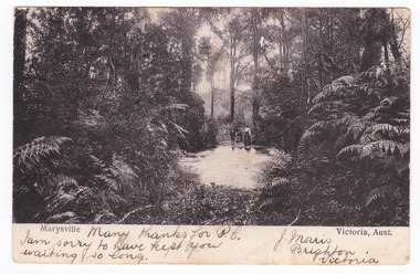
Postcard (item) - Black and white postcard, Nicholas John Caire, Marysville Victoria, Aust, 1858-1918
One of a series of postcards of photographs taken by socialite photographer Nicholas John Caire. N.J. Caire had a great love for the area and in the late 1800's took many photographs of Marysville and its surrounds.One of a series of postcards of photographs taken by socialite photographer Nicholas John Caire. N.J. Caire had a great love for the area in and surrounding Marysville and in the late 1800's took many photographs of Marysville and its surrounds. N.J. Caire was born in 1837 in Guernsey. He arrived in Adelaide about 1860 along with his parents who encouraged his early interest in photography. He opened a studio in Adelaide in 1867 after traveling extensively throughout the Gippsland taking photographs. After marrying in 1870 he moved to Talbot in Victoria until 1876 when he opened a studio in the Royal Arcade in Melbourne. After 1885 N.J. Caire gave up his city work and made his home in South Yarra and devoted the rest of his life to outdoor photography, specializing in the bush, the gullies and the mountains of south-eastern Victoria. Many thanks for P.C./ I am sorry to have kept you/ waiting so long. J. Morris/ Brighton/ Victoria POST CARD [THIS SPACE MAY BE USED FOR COMMUNICATION] ]FOR WRITING ADD (rest has been removed when stamp was removed) Mr Herman Frock/ Petersgaard/ Langebak Street/ Denmark Date Stamp/ MELBOURNE/ FEB 2?/ 4.33/ 1906 Date Stamp/ MASNEDSUND/ KALLEHAVE/ 24.3.06.1.4 Stamp/ BILL HOPKINS COLLECTION/ 21 KENSINGTON PARK ROAD W11/ NOTTING HILL GATE LONDON marysville, victoria, nicholas john caire, bill hopkins collection, postcard, souvenir -
Glenelg Shire Council Cultural Collection
Postcard - Postcard - Henty Street, Casterton, n.d
Photo/postcard of part of Henty Street, Casterton, showing Court House, Post Office and Hotel. Reverse has mailing details, brief description of Casterton.souvenir of casterton, casterton, kelpie, kelpie muster -
Glenelg Shire Council Cultural Collection
Postcard - Postcard Photograph - Casterton, Victoria, n.d
Photo/postcard, coloured, view of Casterton taken from Mickle Lookout. Reverse has mailing details, brief description of Casterton. -
Glenelg Shire Council Cultural Collection
Postcard - Postcard - Bailey's Rocks, Casterton, Victoria, n.d
Photo/postcard of Bailey's Rocks, near Casterton. Reverse has mailing details, brief description Bailey's Rocks. -
Glenelg Shire Council Cultural Collection
Postcard - Postcard - Henty Street Casterton, Victoria, n.d
Photo/postcard of section of Henty Street, Casterton, showing newsagents, florist, Town Hall. Reverse has mailing details, brief description of Casterton. -
Glenelg Shire Council Cultural Collection
Postcard - Postcard - Casterton, Victoria, n.d
Photo/postcard, view of Casterton Hotel. Reverse has mailing details and brief description of Casterton Hotel. -
Glenelg Shire Council Cultural Collection
Postcard - Postcard - Old Casterton Courthouse, Victoria, n.d
Photo/postcard of Old Casterton Courthouse, now used as Community Centre. Reverse has mailing details, brief description of Casterton Hotel (this is a mistake, obviously!) -
Glenelg Shire Council Cultural Collection
Postcard - Postcard - Albion Hotel Casterton, Victoria, n.d
Photographic postcard, view of Albion Hotel Motel Casterton, reverse has mailing details, brief description of Albion. -
Glenelg Shire Council Cultural Collection
Postcard - Postcard - Casterton, Victoria, n.d
Photo/postcard, view of Casterton Post Office. Reverse has mailing details and brief description of Casterton. -
Glenelg Shire Council Cultural Collection
Postcard - Postcard - Casterton, Victoria, n.d
Photo/postcard, view of Scots Uniting Church, Casterton. Reverse has mailing details, brief details of Scotch (sic) Uniting Church. -
 City of Moorabbin Historical Society (Operating the Box Cottage Museum)
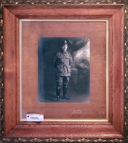
Photograph - Alonzo Box in Army Uniform c1915, Unrecorded, c1915
Alonzo Box was the nephew of William and Elizabeth Box who resided in the Cottage 1865 - 1913. He was the 9th child of John Box 1841 - 1913 and Martha Sheldrake Box who lived in Oakleigh, Alonzo enlisted in the Army and landed at Gallipoli 25/41915. After the evacuation to Egypt he served in France and Flanders and returned to Melbourne February 1918. Alonzo was a pavier / pitcher who was employed to lay the bluestone drains for the roads and sewerage channels in Moorabbin Shire - a skilled and well paid occupation. Alonzo Box was the 9th child of John Box ,who emigrated to Australia in 1854 with his parents, George and Mary Box , and siblings who included William Box. Alonzo enlisted in the 1st AIF and landed at Gallipoli 25/4/1915. After the evacuation to Egypt he served in France and Flanders before returning to Melbourne in February 1918. He married Mary Closter in June 1918. His elder sister Rebecca, who was a missionary in China, sent a bolt of hand embroidered Chinese silk to Mary for her Wedding Dress. This unique dress is on display at Box Cottage Museum and is recorded on the Australian Dress Register 2015.A large photograph in a wooden frame of Alonzo Box 1881-1958 in 1st AIF Army Uniform c 1915box william, box elizabeth, box alonzo, box mary, closter mary, moorabbin, brighton, bentleigh, ormond, mckinnon, market gardeners, pioneers, early settlers, paviers, roads, sewers, world war 1914-1918, anzac, gallipoli, uniforms australian army, box john, sheldrake martha