Showing 203 items
matching city boundary
-
 Kew Historical Society Inc
Plan, Melbourne & Metropolitan Board of Works : Borough of Kew : Detail Plan No.1568, 1905
The Melbourne and Metropolitan Board of Works (MMBW) plans were produced from the 1890s to the 1950s. They were crucial to the design and development of Melbourne's sewerage and drainage system. The plans, at a scale of 40 feet to 1 inch (1:480), provide a detailed historical record of Melbourne streetscapes and environmental features. Each plan covers one or two street blocks (roughly six streets), showing details of buildings, including garden layouts and ownership boundaries, and features such as laneways, drains, bridges, parks, municipal boundaries and other prominent landmarks as they existed at the time each plan was produced. (Source: State Library of Victoria)This plan forms part of a large group of MMBW plans and maps that was donated to the Society by the Mr Poulter, City Engineer of the City of Kew in 1989. Within this collection, thirty-five hand-coloured plans, backed with linen, are of statewide significance as they include annotations that provide details of construction materials used in buildings in the first decade of the 20th century as well as additional information about land ownership and usage. The copies in the Public Record Office Victoria and the State Library of Victoria are monochrome versions which do not denote building materials so that the maps in this collection are invaluable and unique tools for researchers and heritage consultants. A number of the plans are not held in the collection of the State Library of Victoria so they have the additional attribute of rarity.Original survey plan, issued by the MMBW to a contractor with responsibility for constructing sewers in the area identified on the plan within the Borough of Kew. The plan was at some stage hand-coloured, possibly by the contractor, but more likely by officers working in the Engineering Department of the Borough and later Town, then City of Kew. The hand-coloured sections of buildings on the plan were used to denote masonry or brick constructions (pink), weatherboard constructions (yellow), and public buildings (grey). Plan No.1568 covers the area bounded by Cotham Road, John Street, Sackville Street, and Edward Street. Alfred Street and Rowland Street are in shown in the middle of the plan. The two most notable buildings shown are ‘St Helliers’, the home of the Dumaresq family, and St Hilary’s Church and school. While the colours used to indicate St Hilary’s are grey as in other civic/public buildings, the first St Hilary’s Anglican Church was at this stage constructed in weatherboard. At the left of the plan, facing Sackville Street is a house named ‘Glencara’. The 1988 ‘Kew Conservation Study’ recorded that “The first documentary evidence of this house comes from Rate Books which record that in 1893 a Mrs Treadway was the owner of this building with an N.A.V. of £81? At that date the occupier of the house was Charles B. Kelly, a clerk, while by 1910 Kelly had become the owner of the property described in that year ‘as a six-roomed stone, brick and wood house with stables and outbuildings’”. Contrary to this description, the 1905 plan indicates that the house was entirely constructed of masonry.melbourne and metropolitan board of works, detail plans, mmbw 1568 -
 Kew Historical Society Inc
Plan, Melbourne & Metropolitan Board of Works : Borough of Kew : Detail Plan No.1569, 1905
The Melbourne and Metropolitan Board of Works (MMBW) plans were produced from the 1890s to the 1950s. They were crucial to the design and development of Melbourne's sewerage and drainage system. The plans, at a scale of 40 feet to 1 inch (1:480), provide a detailed historical record of Melbourne streetscapes and environmental features. Each plan covers one or two street blocks (roughly six streets), showing details of buildings, including garden layouts and ownership boundaries, and features such as laneways, drains, bridges, parks, municipal boundaries and other prominent landmarks as they existed at the time each plan was produced. (Source: State Library of Victoria)This plan forms part of a large group of MMBW plans and maps that was donated to the Society by the Mr Poulter, City Engineer of the City of Kew in 1989. Within this collection, thirty-five hand-coloured plans, backed with linen, are of statewide significance as they include annotations that provide details of construction materials used in buildings in the first decade of the 20th century as well as additional information about land ownership and usage. The copies in the Public Record Office Victoria and the State Library of Victoria are monochrome versions which do not denote building materials so that the maps in this collection are invaluable and unique tools for researchers and heritage consultants. A number of the plans are not held in the collection of the State Library of Victoria so they have the additional attribute of rarity.Original survey plan, issued by the MMBW to a contractor with responsibility for constructing sewers in the area identified on the plan within the Borough of Kew. The plan was at some stage hand-coloured, possibly by the contractor, but more likely by officers working in the Engineering Department of the Borough and later Town, then City of Kew. The hand-coloured sections of buildings on the plan were used to denote masonry or brick constructions (pink), weatherboard constructions (yellow), and public buildings (grey). This plan covers parts of Sackville Street, John Street, Thomas Street and Cotham Road, and includes several very large houses in Sackville Street. Job Smith built ‘Berrington’ in about 1888-90 for himself, and ‘Pomeroy’ (now ‘Merridale’) in 1885 for James Mickleburgh. ‘Heathfield’ was built in 1888 for Henry Eeles, and was one of many fine homes in Kew, Hawthorn and surrounding suburbs designed by prolific architect John Beswicke; it later became “La Verna” and was a Franciscan monastery. Similarly, in Cotham Road, we can see ‘Bella Vista’ (now demolished), and ‘Charleville’, with its double-storeyed arcade frontage, built in 1889 for Charles Donaldson whose family occupied it until 1939. This was renamed ‘Ross House’ by the second owner, Dr. Thomas King, and then substantially restored in the 1960s by the Stillwell family, well known as car drivers and dealers. Bella Vista (later ‘Malinda’) was originally designed by the architect Robert Haddon and built for Abel Hoadley, inventor of the Violet Crumble Bar and many other delicious delicacies. He began by manufacturing jams and pickles in South Melbourne using fruit from his own orchard in East Burwood.melbourne and metropolitan board of works, detail plans, mmbw 1569, cartography -
 Kew Historical Society Inc
Plan, Melbourne & Metropolitan Board of Works : Borough of Kew : Detail Plan No.1570, 1905
The Melbourne and Metropolitan Board of Works (MMBW) plans were produced from the 1890s to the 1950s. They were crucial to the design and development of Melbourne's sewerage and drainage system. The plans, at a scale of 40 feet to 1 inch (1:480), provide a detailed historical record of Melbourne streetscapes and environmental features. Each plan covers one or two street blocks (roughly six streets), showing details of buildings, including garden layouts and ownership boundaries, and features such as laneways, drains, bridges, parks, municipal boundaries and other prominent landmarks as they existed at the time each plan was produced. (Source: State Library of Victoria)This plan forms part of a large group of MMBW plans and maps that was donated to the Society by the Mr Poulter, City Engineer of the City of Kew in 1989. Within this collection, thirty-five hand-coloured plans, backed with linen, are of statewide significance as they include annotations that provide details of construction materials used in buildings in the first decade of the 20th century as well as additional information about land ownership and usage. The copies in the Public Record Office Victoria and the State Library of Victoria are monochrome versions which do not denote building materials so that the maps in this collection are invaluable and unique tools for researchers and heritage consultants. A number of the plans are not held in the collection of the State Library of Victoria so they have the additional attribute of rarity.Original survey plan, issued by the MMBW to a contractor with responsibility for constructing sewers in the area identified on the plan within the Borough of Kew. The plan was at some stage hand-coloured, possibly by the contractor, but more likely by officers working in the Engineering Department of the Borough and later Town, then City of Kew. The hand-coloured sections of buildings on the plan were used to denote masonry or brick constructions (pink), weatherboard constructions (yellow), and public buildings (grey). Plan No.1570 shows the layout of gardens and houses in Sackville Street, Davis Street, Wrixon Street, and Fitzwilliam Street in 1904. While Thomas Street is included on the map, at this stage no houses had been built. The plan identifies two named houses: ‘Fairview’ and ‘Kylemore’. Fairview is more fully delineated in Plan No.1563. Kylemore is one of the few houses in Kew designed by John Beswicke. The most notable owner of Kylemore was William Whitehead, who owned the house between 1895 and 1900. In 1894, Australian newspapers reported the marriage of Whitehead’s daughter to Dr. Gerald Eugene Cussen, the brother of Sir Leo Cussen, the Supreme Court Judge. The married couple was to live at ‘Wilton’ (now the Kew RSL) from 1911-15.melbourne and metropolitan board of works, detail plans, mmbw 1570, cartography -
 Kew Historical Society Inc
Plan, Melbourne & Metropolitan Board of Works : Borough of Kew : Detail Plan No.1571, 1904
The Melbourne and Metropolitan Board of Works (MMBW) plans were produced from the 1890s to the 1950s. They were crucial to the design and development of Melbourne's sewerage and drainage system. The plans, at a scale of 40 feet to 1 inch (1:480), provide a detailed historical record of Melbourne streetscapes and environmental features. Each plan covers one or two street blocks (roughly six streets), showing details of buildings, including garden layouts and ownership boundaries, and features such as laneways, drains, bridges, parks, municipal boundaries and other prominent landmarks as they existed at the time each plan was produced. (Source: State Library of Victoria)This plan forms part of a large group of MMBW plans and maps that was donated to the Society by the Mr Poulter, City Engineer of the City of Kew in 1989. Within this collection, thirty-five hand-coloured plans, backed with linen, are of statewide significance as they include annotations that provide details of construction materials used in buildings in the first decade of the 20th century as well as additional information about land ownership and usage. The copies in the Public Record Office Victoria and the State Library of Victoria are monochrome versions which do not denote building materials so that the maps in this collection are invaluable and unique tools for researchers and heritage consultants. A number of the plans are not held in the collection of the State Library of Victoria so they have the additional attribute of rarity.Digital copy of the original survey plan, issued by the MMBW to a contractor with responsibility for constructing sewers in the area identified on the plan within the Borough of Kew. The plan was at some stage hand-coloured, possibly by the contractor, but more likely by officers working in the Engineering Department of the Borough and later Town, then City of Kew. The hand-coloured sections of buildings on the plan were used to denote masonry or brick constructions (pink), weatherboard constructions (yellow), and public buildings (grey). This plan is part of a large and historically significant group of MMBW plans and maps that was donated to the Society by the Mr Poulter, City Engineer of the City of Kew in 1989. When the contracts were let for surveyors to identify and record the extant houses and landscapes within an area for the Board of Works, the contracts were let at separate times, hence the anomaly where two copies of Plan No.1571 exist in our collection. The first of these plans identifies the building materials used in houses bordering Fitzwilliam Street, Edgevale Road, May Street, Malin Street, Davis Street and Wellington Street. The cut off point for the survey was the south side of Wellington Street. By 1903 when the survey was undertaken many of the sites were already built on, particularly those facing Edgevale Road. The plan identifies the preponderance of weatherboard houses in the area. The other version of the plan identifies the buildings between Wellington Street and Cotham Road.melbourne and metropolitan board of works, detail plans, mmbw 1571, cartography -
 Kew Historical Society Inc
Plan, Melbourne & Metropolitan Board of Works : Borough of Kew : Detail Plan No.1571, 1904
The Melbourne and Metropolitan Board of Works (MMBW) plans were produced from the 1890s to the 1950s. They were crucial to the design and development of Melbourne's sewerage and drainage system. The plans, at a scale of 40 feet to 1 inch (1:480), provide a detailed historical record of Melbourne streetscapes and environmental features. Each plan covers one or two street blocks (roughly six streets), showing details of buildings, including garden layouts and ownership boundaries, and features such as laneways, drains, bridges, parks, municipal boundaries and other prominent landmarks as they existed at the time each plan was produced. (Source: State Library of Victoria)This plan forms part of a large group of MMBW plans and maps that was donated to the Society by the Mr Poulter, City Engineer of the City of Kew in 1989. Within this collection, thirty-five hand-coloured plans, backed with linen, are of statewide significance as they include annotations that provide details of construction materials used in buildings in the first decade of the 20th century as well as additional information about land ownership and usage. The copies in the Public Record Office Victoria and the State Library of Victoria are monochrome versions which do not denote building materials so that the maps in this collection are invaluable and unique tools for researchers and heritage consultants. A number of the plans are not held in the collection of the State Library of Victoria so they have the additional attribute of rarity.Original survey plan, issued by the MMBW to a contractor with responsibility for constructing sewers in the area identified on the plan within the Borough of Kew. The plan was at some stage hand-coloured, possibly by the contractor, but more likely by officers working in the Engineering Department of the Borough and later Town, then City of Kew. The hand-coloured sections of buildings on the plan were used to denote masonry or brick constructions (pink), weatherboard constructions (yellow), and public buildings (grey). This plan is the other half of Plan No.1571 representing the constructions to the west of Wellington Street before and in 1903/4. This plan represents the built environment in Edgevale Road, Wellington Street, Atkins Street, Annadale Street, Mortimer Street, and Cotham Road. Whereas there are smaller allotments and more modest housing stock facing Edgevale Road, larger blocks and more substantial houses are represented facing Cotham Road.melbourne and metropolitan board of works, detail plans, mmbw 1571, cartography -
 Kew Historical Society Inc
Plan, Melbourne & Metropolitan Board of Works : Borough of Kew : Detail Plan No.1572, 1905
The Melbourne and Metropolitan Board of Works (MMBW) plans were produced from the 1890s to the 1950s. They were crucial to the design and development of Melbourne's sewerage and drainage system. The plans, at a scale of 40 feet to 1 inch (1:480), provide a detailed historical record of Melbourne streetscapes and environmental features. Each plan covers one or two street blocks (roughly six streets), showing details of buildings, including garden layouts and ownership boundaries, and features such as laneways, drains, bridges, parks, municipal boundaries and other prominent landmarks as they existed at the time each plan was produced. (Source: State Library of Victoria)This plan forms part of a large group of MMBW plans and maps that was donated to the Society by the Mr Poulter, City Engineer of the City of Kew in 1989. Within this collection, thirty-five hand-coloured plans, backed with linen, are of statewide significance as they include annotations that provide details of construction materials used in buildings in the first decade of the 20th century as well as additional information about land ownership and usage. The copies in the Public Record Office Victoria and the State Library of Victoria are monochrome versions which do not denote building materials so that the maps in this collection are invaluable and unique tools for researchers and heritage consultants. A number of the plans are not held in the collection of the State Library of Victoria so they have the additional attribute of rarity.Original survey plan, issued by the MMBW to a contractor with responsibility for constructing sewers in the area identified on the plan within the Borough of Kew. The plan was at some stage hand-coloured, possibly by the contractor, but more likely by officers working in the Engineering Department of the Borough and later Town, then City of Kew. The hand-coloured sections of buildings on the plan were used to denote masonry or brick constructions (pink), weatherboard constructions (yellow), and public buildings (grey). Plan No. 1572 represents the built environment bordered by Barkers Road, Wrixon Street, Edgevale Road and Fitzwilliam Street. Other streets identified on the plan include Stansell Street. Plan 1572 shows that by 1903-05, there was only patchy development in this area of Kew, mainly on Edgevale Road and Fitzwilliam Street. Only two named houses are identified: the quaintly named ‘Tweed Cottage’, and ‘Mendip’. The earliest reference to Treed Cottage in Australian newspapers is to the death of Walter Thompson, aged 74 who was a resident there in 1885. His youngest daughter was to die there in 1908. Mendip to the north of Tweed Cottage was owned by Henry Thompson; he was to die in 1901; his wife in 1932. At this period of time, Malin Street and Clivedon Court did not extend to Barkers Road.melbourne and metropolitan board of works, detail plans, mmbw 1572, cartography -
 Kew Historical Society Inc
Plan, Melbourne & Metropolitan Board of Works : Borough of Kew : Detail Plan No.1573, 1905
The Melbourne and Metropolitan Board of Works (MMBW) plans were produced from the 1890s to the 1950s. They were crucial to the design and development of Melbourne's sewerage and drainage system. The plans, at a scale of 40 feet to 1 inch (1:480), provide a detailed historical record of Melbourne streetscapes and environmental features. Each plan covers one or two street blocks (roughly six streets), showing details of buildings, including garden layouts and ownership boundaries, and features such as laneways, drains, bridges, parks, municipal boundaries and other prominent landmarks as they existed at the time each plan was produced. (Source: State Library of Victoria)This plan forms part of a large group of MMBW plans and maps that was donated to the Society by the Mr Poulter, City Engineer of the City of Kew in 1989. Within this collection, thirty-five hand-coloured plans, backed with linen, are of statewide significance as they include annotations that provide details of construction materials used in buildings in the first decade of the 20th century as well as additional information about land ownership and usage. The copies in the Public Record Office Victoria and the State Library of Victoria are monochrome versions which do not denote building materials so that the maps in this collection are invaluable and unique tools for researchers and heritage consultants. A number of the plans are not held in the collection of the State Library of Victoria so they have the additional attribute of rarity.Original survey plan, issued by the MMBW to a contractor with responsibility for constructing sewers in the area identified on the plan within the Borough of Kew. The plan was at some stage hand-coloured, possibly by the contractor, but more likely by officers working in the Engineering Department of the Borough and later Town, then City of Kew. The hand-coloured sections of buildings on the plan were used to denote masonry or brick constructions (pink), weatherboard constructions (yellow), and public buildings (grey). This plan has detailed annotations written in red or blue ink, showing prices, which may be the annual valuations of the properties, and some owners’ names, a most unusual feature on contractor's maps. Some areas, such as the buildings of Methodist Ladies’ College (MLC), include the school’s tennis court and swimming pool, but are not coloured to show building materials – did the draftsman just run out of time, or ink, or enthusiasm, before his plan had to be submitted? MLC had been founded in 1882 as a ‘modern school of the first order’ with buildings that formed ‘a collegiate institution for girls unsurpassed in the colonies’. The goal of its founders was to provide a high-class Christian education for girls, comparable with that provided elsewhere for boys. Some shops are shown along Edgevale Road, though they are not designated as commercial premises. Larger houses are depicted, including ‘Fairlawn’ in Barkers Road, and ‘Clevedon’ and ‘Rosehill’ (now demolished) in Fitzwilliam Street.melbourne and metropolitan board of works, detail plans, mmbw 1573, maps - borough of kew, cartography -
 Kew Historical Society Inc
Plan, Melbourne & Metropolitan Board of Works : Borough of Kew : Detail Plan No.1574, 1905
The Melbourne and Metropolitan Board of Works (MMBW) plans were produced from the 1890s to the 1950s. They were crucial to the design and development of Melbourne's sewerage and drainage system. The plans, at a scale of 40 feet to 1 inch (1:480), provide a detailed historical record of Melbourne streetscapes and environmental features. Each plan covers one or two street blocks (roughly six streets), showing details of buildings, including garden layouts and ownership boundaries, and features such as laneways, drains, bridges, parks, municipal boundaries and other prominent landmarks as they existed at the time each plan was produced. (Source: State Library of Victoria)This plan forms part of a large group of MMBW plans and maps that was donated to the Society by the Mr Poulter, City Engineer of the City of Kew in 1989. Within this collection, thirty-five hand-coloured plans, backed with linen, are of statewide significance as they include annotations that provide details of construction materials used in buildings in the first decade of the 20th century as well as additional information about land ownership and usage. The copies in the Public Record Office Victoria and the State Library of Victoria are monochrome versions which do not denote building materials so that the maps in this collection are invaluable and unique tools for researchers and heritage consultants. A number of the plans are not held in the collection of the State Library of Victoria so they have the additional attribute of rarity.Original survey plan, issued by the MMBW to a contractor with responsibility for constructing sewers in the area identified on the plan within the Borough of Kew. The plan was at some stage hand-coloured, possibly by the contractor, but more likely by officers working in the Engineering Department of the Borough and later Town, then City of Kew. The hand-coloured sections of buildings on the plan were used to denote masonry or brick constructions (pink), weatherboard constructions (yellow), and public buildings (grey). This plan shows several very large houses, particularly along Glenferrie Road, and the area now occupied by Ruyton Girls’ School. ‘Tarring’ (incorrectly spelled here as ‘Karring’) was built for Henry Henty in 1872, on part of his original allotment of 20 acres, and ‘Mount View’, which retains its original building and the fountain in the front garden, is part of Ruyton’s Junior School. The most significant change to Tarring and its grounds since 1903, involve the removal of a number of the outbuildings, including a Burmese temple, bought by Henty from the Burmese Exhibit at the Great Exhibition of 1880. It is shown on the plan as a summerhouse. The two-storey mansion, on the corner of Glenferrie Road and Wellington Street, was built in 1891 by leading architect Alfred White as his own home. Having an initial N.A.V. of £160, the house was purchased by a warehouseman Henry Lister, by 1900, when the N.A.V. was recorded at £111. By the turn of the century the house was known as ‘Comaques’. By contrast, much smaller houses are shown in Scott and Byron Streets, including a tiny Mission Hall in Byron Street, which belonged to the Anglican Church from at least 1903 to 1917.melbourne and metropolitan board of works, detail plans, maps - borough of kew, mmbw 1574, cartography -
 Kew Historical Society Inc
Plan, Melbourne & Metropolitan Board of Works : Borough of Kew : Detail Plan No.1575, 1905
The Melbourne and Metropolitan Board of Works (MMBW) plans were produced from the 1890s to the 1950s. They were crucial to the design and development of Melbourne's sewerage and drainage system. The plans, at a scale of 40 feet to 1 inch (1:480), provide a detailed historical record of Melbourne streetscapes and environmental features. Each plan covers one or two street blocks (roughly six streets), showing details of buildings, including garden layouts and ownership boundaries, and features such as laneways, drains, bridges, parks, municipal boundaries and other prominent landmarks as they existed at the time each plan was produced. (Source: State Library of Victoria)This plan forms part of a large group of MMBW plans and maps that was donated to the Society by the Mr Poulter, City Engineer of the City of Kew in 1989. Within this collection, thirty-five hand-coloured plans, backed with linen, are of statewide significance as they include annotations that provide details of construction materials used in buildings in the first decade of the 20th century as well as additional information about land ownership and usage. The copies in the Public Record Office Victoria and the State Library of Victoria are monochrome versions which do not denote building materials so that the maps in this collection are invaluable and unique tools for researchers and heritage consultants. A number of the plans are not held in the collection of the State Library of Victoria so they have the additional attribute of rarity.Original survey plan, issued by the MMBW to a contractor with responsibility for constructing sewers in the area identified on the plan within the Borough of Kew. The plan was at some stage hand-coloured, possibly by the contractor, but more likely by officers working in the Engineering Department of the Borough and later Town, then City of Kew. The hand-coloured sections of buildings on the plan were used to denote masonry or brick constructions (pink), weatherboard constructions (yellow), and public buildings (grey). Plan No.1575 shows that in the area bounded by Wellington Street, Edgevale Road, Glenferrie Road, and Cotham Road, there had already been significant subdivision of land and houses constructed. As one of the highest points in Kew, as expected, there were already some significant mansions built on large allotments of land. Many of these mansions are identified by name on the plan such as ‘Kelso’, ‘Abbotsford’, ‘Clarendon’ and ‘Ashlyn’ in Cotham Road. Other houses of equal size are unnamed on the plan.melbourne and metropolitan board of works, detail plans, maps - borough of kew, mmbw 1575, cartography -
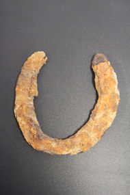 Glen Eira City Council History and Heritage Collection
Horseshoe
The horseshoe was found during excavating the site for the development of GESAC, East Boundary Road, Bentleigh. Iron horseshoe, U-shaped, dark and corroded with concretion / accretion of rusty coloured debris over much of the surface.No legible inscriptions. -
 Glen Eira City Council History and Heritage Collection
Document (Item) - Newspaper (digital), Caulfield Contact
The Caulfield Contact was the official newspaper of the City of Caulfield from 1976-1994. The City of Caulfield was the Municipal Council for an area of the South Eastern suburbs of Melbourne, including Brighton East, Carnegie, Caulfield, Elsternwick, Gardenvale, Glen Huntly, McKinnon, Murrumbeena, Ormond and St Kilda East. Following the amalgamation of City of Caulfield and parts of the City of Moorabbin in 1994, the municipality was renamed the City of Glen Eira. The Caulfield Contact was replaced by the Glen Eira News. 320-001-1976-001-001-07-28 Vol 1 edition 1 July 1976 Twenty-fifth (25th) anniversary of home help service; Profiles on Councillors Ray Mann, David Nolan; Murray and Wells call out for historical material; Resident's proposal for ward boundary changes accepted by Council, Profiles Councillor Bert Caldwell, Stan Hunter Town Hall Reprieve, History of Caulfield First Caulfield Arbor Day, Results of Council Elections held on 26 August 1976 city of caulfield, caulfield, history of caulfield, glen eira -
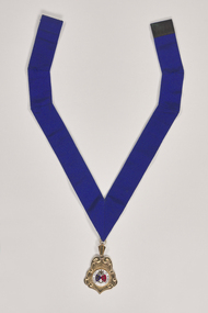 City of Greater Bendigo - Civic Collection
Ceremonial object - Rural City of Marong Medal, Blashki & Sons
The first local government authority for Marong was the Marong Road District (an early form of single-purpose local government), which was proclaimed on 19 August 1860. Its boundary was altered twice in 1862 and on 12 December 1864 it was re designated as a shire. It absorbed Raywood Borough in 1915, and was proclaimed a Rural City in 1990. On 2 December 1994, with the creation of Greater Bendigo City Council, it was abolished by being amalgamated with Bendigo City, Eaglehawk Borough, Huntly Shire, part of McIvor Shire, part of Metcalfe Shire and Strathfieldsaye Shire to form Greater Bendigo City.Rural City of Marong Stirling silver drop, plated in 22 ct gold with enamel centre piece. Medallion hangs from a royal blue neck ribbon. front; RURAL CITY OF MARONG / verso; FORMED AS / MARONG DISTRICT ROADS BOARD / 27th AUGUST 1861 / PROCLAIMED SHIRE OF MARONG / 23rd DECEMBER 1864 / PROCLAIMED RURAL CITY OF MARONG / 1st OCTOBER 1990shire of marong, city of greater bendigo ceremonial item -
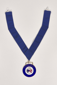 City of Greater Bendigo - Civic Collection
Ceremonial object - Shire of Marong President Medallion, P Blashki & Sons
The first local government authority for Marong was the Marong Road District (an early form of single-purpose local government), which was proclaimed on 19 August 1860. Its boundary was altered twice in 1862 and on 12 December 1864 it was re designated as a shire. It absorbed Raywood Borough in 1915, and was proclaimed a Rural City in 1990. On 2 December 1994, with the creation of Greater Bendigo City Council, it was abolished by being amalgamated with Bendigo City, Eaglehawk Borough, Huntly Shire, part of McIvor Shire, part of Metcalfe Shire and Strathfieldsaye Shire to form Greater Bendigo City.Manufactured by Blashki and Son this circular medal hangs from a royal blue gosgrain ribbon. The medallion has a gold edging with blue enamel outer band. Centre depicts Australia coat of arms and the Shire of Marong coat of arms.PRESIDENT / SHIRE OF MARONG / DIEU ET MON DROIT / INDUSTRIAshire of marong, marong presidents medal, city of greater bendigo ceremonial item -
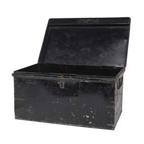
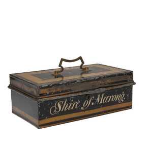 City of Greater Bendigo - Civic Collection
Functional object, Shire of Marong, Unknown
The first local government authority for Marong was the Marong Road District (an early form of single-purpose local government), which was proclaimed on 19 August 1860. Its boundary was altered twice in 1862 and on 12 December 1864 it was re designated as a shire. It absorbed Raywood Borough in 1915, and was proclaimed a Rural City in 1990. On 2 December 1994, with the creation of Greater Bendigo City Council, it was abolished by being amalgamated with Bendigo City, Eaglehawk Borough, Huntly Shire, part of McIvor Shire, part of Metcalfe Shire and Strathfieldsaye Shire to form Greater Bendigo City.Painted metal tin with handle on top. Currently locked closed.Shire of Marongshire of marong -
 City of Greater Bendigo - Civic Collection
Functional object - Metal Box, Unknown
The first local government authority for Marong was the Marong Road District (an early form of single-purpose local government), which was proclaimed on 19 August 1860. Its boundary was altered twice in 1862 and on 12 December 1864 it was re designated as a Shire. It absorbed Raywood Borough in 1915, and was proclaimed a Rural City in 1990. On 2 December 1994, with the creation of Greater Bendigo City Council, it was abolished by being amalgamated with Bendigo City, Eaglehawk Borough, Huntly Shire, part of McIvor Shire, part of Metcalfe Shire and Strathfieldsaye Shire to form the City of Greater Bendigo. This metal box contained a roll of admission tickets and was possibly used for holding cash at the swimming pool or other municipal facility. Lockable painted metal box. Shire of Marongshire of marong -
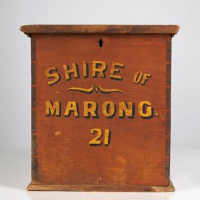 City of Greater Bendigo - Civic Collection
Functional object - Ballot Box, Shire of Marong, Shire of Marong 21, Unknown
The first local government authority for Marong was the Marong Road District (an early form of single-purpose local government), which was proclaimed on 19 August 1860. Its boundary was altered twice in 1862 and on 12 December 1864 it was re designated as a Shire. It absorbed Raywood Borough in 1915, and was proclaimed a Rural City in 1990. On 2 December 1994, with the creation of Greater Bendigo City Council, it was abolished through the amalgamation which took place between Bendigo City, Eaglehawk Borough, Huntly Shire, part of McIvor Shire, part of Metcalfe Shire and Strathfieldsaye Shire to form the City of Greater Bendigo. This box would have been used to collect votes during council elections.Wooden, painted, lidded box with hinged opening lid. Central slit in lid to insert ballot papers. Front face painted in black and gold paint. Hinged at back of box with lock on front. Front of box Shire of / Marong / 21shire of marong -
 City of Greater Bendigo - Civic Collection
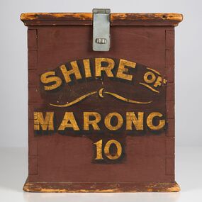
Functional object - Ballot Box, Shire of Marong, Shire of Marong 10, Unknown
The first local government authority for Marong was the Marong Road District (an early form of single-purpose local government), which was proclaimed on 19 August 1860. Its boundary was altered twice in 1862 and on 12 December 1864 it was re designated as a Shire. It absorbed Raywood Borough in 1915, and was proclaimed a Rural City in 1990. On 2 December 1994, with the creation of Greater Bendigo City Council, it was abolished through the amalgamation which took place between Bendigo City, Eaglehawk Borough, Huntly Shire, part of McIvor Shire, part of Metcalfe Shire and Strathfieldsaye Shire to form the City of Greater Bendigo. This box would have been used to collect votes during council elections.Wooden painted, lidded box with hinged opening lid. Central slit in lid to insert ballot papers. Front face painted in black and gold paint. Hinged at front of box with lock on back. Handle attached to the back.Front of box; Shire of / Marong / 21shire of marong -
Canterbury History Group
Document - Deed between the Mayor, Councillors and the Citizens of Camberwell and the Canterbury Bowling Club, 1955
Deed allowing the Canterbury Bowling Club the right to occupy land adjacent to the southern boundary of the bowling green, subject to conditions as set out on the Deed between the club and rhe City of Camberwellcanterbury, canterbury bowling club, kendall street, lawn bowls, city of camberwell, goble> george, maclean> george, etherington> arthur, maps, legal documents -
Friends of Ballarat Botanical Gardens History Group
Work on paper - Plans for Fencing the Ballarat Botanical Gardens, 2002, Problems With Vandalism and Theft, March, 2003
Fencing of Ballarat Botanical Gardens, because of problems with vandalism and theft. The reasons for the fencing of the Botanical Gardens are stated along with the aim to have the fencing appropriate to the style of the Gardens.2 pages. p.2 has plans on both sides of the page. Wendouree Parade fencing, p.2 and Proposed Fencing Scheme, p.3.The three pages have the Begonia logo in black and white with Ballarat Botanical Gardens superimposed and by Lake Wendouree below in smaller print.john garner collection, garner, dr, fence, vandalism, ballarat botanical gardens, ballarat, gardens, theft, proposed fencing scheme, wendouree parade fencing, elevation detail, adam parrott, ballarat city council, local law no.6, south gardens boundary, lych gates, elevation detail. -
 Wyndham Art Gallery (Wyndham City Council)
Sculpture, Nandita Nadkarni, Crafted Clay Odyssey, 2023
Winner Wyndham Art Prize LEAP Award 2023 -
Camberwell Historical Society
Pamphlet (Item), City of Boroondara
... , and flyer on City of Boroondara electoral ward boundaries City ...boroondara, camberwell -
 City of Kingston
Photograph - Black and white, c. 1960
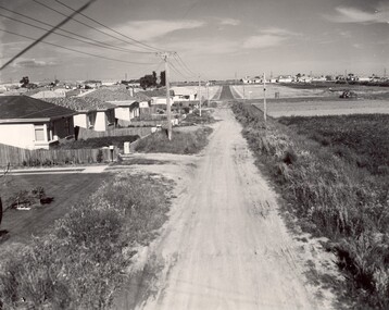
This image depicts a scene of East Bentleigh in 1960, viewed along Thomasina Street as it crosses Gladwyn Street towards East Boundary Road in the distance. The gardens and new homes are well-tended, but the street surfacing is unsealed.Developing urban area now located within the City of Glen Eira, formally City of Moorabbin. This image illustrates the mid century urban sprawl of new suburbs and the subdivision of market gardens within the municipality and the changing demographic of the district as new houses are constructed and infrastructure established. Black and white photograph of unsealed road in new development in the area of Moorabbin, new houses appear on the lefthand side with paddocks on right side of image with installation of electric poles. Sealed road in the distance. Thomasina Street, as it crosses Gladwyn Street, East Bentleigh towards East Boundary Road. Handwritten in blue ink: 60 - 373 D Handwritten in red ink: 80% Handwritten in black ink: Ch. 6bentleigh, east bentleigh, market garden, housing, suburbs, infrastructure, moorabbin -
 City of Kingston
Photograph - Black and white, c. 1956
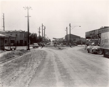
Strip shopping and ample parking were features of suburbs in the middle of the twentieth centuries. Cars were still considered a luxury, although that would soon change, and local, independent shops serviced local areas.During the post-war years, the municipality of Moorabbin experienced a population boom. The 'newcomers' were predominantly returnees from the war who were marrying and establishing families; those from the old inner-suburban areas who were moving away from rented premises to establish their own homes on cheap land. The 1950s were a time of immense growth for the area now known as City of Kingston.Black and white photograph of the intersection of Centre and East Boundary roads, Bentleigh East. Several cars are visible both in the foreground and background, and the intersection includes a roundabout. The street is lined with poles to carry electricity cables, and the roundabout is dotted with four poles for electric street lights.Handwritten in blue ink: 56 - 230 Handwritten in red ink: 82% Handwritten in black ink: Ch. 6shopping strip, cars, suburbs -
 City of Kingston
Photograph - Black and white, 1962
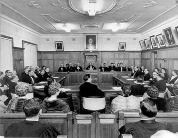
Local government for Moorabbin began in 1862 when the area was separated from Brighton with the creation of the Moorabbin Roads Board. This meeting commemorated the centenary of local government in 1962.1862 saw the beginnings of local government in the Moorabbin district when the area was separated from Brighton with the creation of the Moorabbin Roads Board. Moorabbin was declared a shire in 1871 and a city in 1934. While tinkering with boundaries occurred over time, the first major severance from Moorabbin was when the Borough of Sandringham was created in 1917. Three years later, after persistent agitation, on May 27, 1920 Mordialloc, Parkdale and Mentone became part of the new Borough of Mordialloc. With this change the Shire of Moorabbin no longer had authority for land with a frontage to Port Phillip Bay. In 1994 councils across Victoria were amalgamated and the City of Moorabbin was divided between the cities of Kingston and Glen Eira. The City of Kingston is made up the former cities of Chelsea, Mordialloc, Moorabbin, Oakleigh and Springvale.Black and white image of inside of Moorabbin Council Chambers, with a meeting (possibly staged) in progress. Council members are seated behind a bench which connects to a horseshoe shaped table. All in attendance are in formal attire. Men are wearing black tie and the women in the audience (with backs to camera) are wearing fur coats or stoles.Black printed text of white round sticker adhered to reverse: 191 Handwritten in red ink: 80%moorabbin, council, chambers, council meeting, centenary -
 City of Kingston
Photograph - Black and white, c.1930
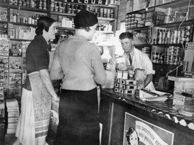
This photograph shows Judd's Grocery Shop located at 224 Charman Road, Cheltenham in the 1930's. Alan Hutchins is the shop attendant, serving two patrons; Merle Judd (left) and Marion Elliott (right). Judd's Grocery Shop was opened by Clarence Judd in the 1920's and was a successor to the family's business formerly located on the corner of Centre and East Boundary Roads, East Bentleigh. Cheltenham had become an established village during the 1920's and Charman Road represented a second, more commercial development in the area. Black and white photograph of a grocery shop interior displaying a variety of items for sale. A male stands behind a counter, looking at the camera. Two females stand in front of the counter facing the male. One female is wearing a hat. Handwritten in blue ink: 181 Handwritten in red ink: 72%shopping, strip shopping, cheltenham, charman rd, grocery -
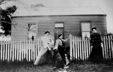 City of Kingston
Photograph - Black and white, c. 1910
The cottage was located on East Boundary Road, near Caleb Street in East Bentleigh. It was owned by Caleb Porter and occupied by Laura Johnson (centre). Also in the photograph are her sister Boletta Hansen Wold (left) and daughter Anna Marie Johnson (right). The dog's name has not been recordedPart of East Bentleigh was inside the original grant of land bought by English farmer and brewer, Henry Dendy, in 1841. He bought 5,120 acres (20.7 km2) which was bounded on the west by Port Phillip Bay, then North Road, East Boundary Road and South Road.Black and white image of three women and a dog standing outside a small weatherboard cottage with a picket fence. Round white sticker with black printed text: 140 Handwritten in red ink: 55%east bentleigh, caleb porter, laura johnson, boletta hansen wold, anna marie johnson -
 City of Kingston
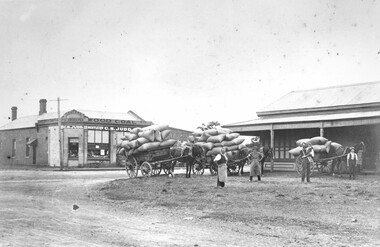
Photograph - Black and white, 1914
Judd's General Store was on the corner of Centre and East Boundary roads in East Bentleigh. This image shows unsealed roads at an intersection with loaded wagons for transporting (or recently transported). The building in the immediate background has a ghost sign which is now illegible. The photograph was apparently taken nine (9) days after the declaration of World War I. Orlando Judd is second from left.Black and white image of four men standing outside in front of three horse drawn wagons loaded with hessian bags. They are standing in front of Judd's General Store which was on the corner of Centre and East Boundary roads, East Bentleigh.White round sticker on reverse with black printed text: 79 Handwritten in red ink on reverse: 60%east bentleigh, horses, horse drawn wagon, commerce -
 City of Kingston
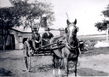
Photograph - Black and white, c. 1920
Vic Peterson and his mother, Ida Peterson, are seated in a carriage with a horse harnessed to the front. Their property was between East Boundary and Brady Road, East Bentleigh.Black and white image of a horse and cart, with a man and woman sitting in the cart.Black ink printed on white round sticker on reverse: 335 Handwritten in red ink on reverse: 70%horse drawn wagon, east bentleigh -
Glen Eira Historical Society
Book - Ormond Amateur Football Club
This file contains two items: 1/A 50 page book on history of Ormond Junior Football Club, from its days as St. Annes Football Club to its amalgamation with Ormond Amateur Football. Book compiled by Claire Barton from AGM meetings 2009. 2/A copy of six football club addresses from the city of Moorabbin Community Directory 1987.ormond junior football club, stock jack, stevens harold r., st. annes church hall, halls, maylan street, east bentleigh, bentleigh mckinnon youth club, clubs and associations, smith brian, scott r. ken, steve stevens, keane adrian, oaten max, dight john, southam david, patterson don, stait ron, ceresa jack, forward cyril, moorehouse bob, forward may, heggert joan, morris jill, brabner martene, williams margaret, jackson judy, mcinery loris, mckinnon high school, walnut street, bailey reserve, boundary road, dowling russell, miller ian, keane david, starke neil “speedie.”, red cross, schweppes, sponsors, claremont junior football club, glenorchy football club, hudson peter, heggert keith, hilton ken, ormond blues, barassi ron, dargavel marita, beggs mr., smith mr., kaighal mr., gunn e. e., morcum glen, cochrane b., clark d., tate geoff, dargavel b., pappas sid, melbourne football club, brabner cameron, siderellis terry, morris wayne, burns robbie, kemp malcolm, siderellis tim, tinsley warwick, grant tom, middleton mick, dowling ian, clarke grant, young morgan, dawes bernie, dawes gerry, montgomery peter, peebles gordon, bentleigh bulldogs football club, mckinnon reserve, sheehy marnie, doble john, kerford phil, gleeson ian, rollasom brian, beynon wayne, societal events and activities, sheehy fay, wood ron, mckinnon butchers, brabner graham, begg john, moorabbin ufa, melbourne football club little league, interleague football matches, brandella cup, mccarthy justin, lough chris, montgomery stephen, carey tim, roe anthony, hardy chris, mccarthy justin, thomas matthew, perry richard, birch david, king denise, sparrow family, wilson ron, dupe stephen, karrageorgiov chris, hardy chris, borrett john, edgells darren, sparrow peter, ormond amateur football club, duncan john, beard j., warren e., pearson martin, waldron gary, marwood shane, collingwood vfl, jackson ricky, melbourne vfl, smith terry, richmond vfl, perkin phil, bentleigh juniors, beham m., neville david, taylor stephen, palmer tony, o’hara matt, ‘the cedric keane perpetual trophy’, st. anne’s football club, ormond east, valkstone, glenhuntly, st. patricks, primary schools, st. kilda junior leagues, lightening premiership, measures paul, msjfl u15 best and fairest, birch david, eishold lewis, eishold rohan, murrumbeena j. f. club, vic kick clinic, lough david, pennacchia luigi, best and fairest, buckley mark, rombotis john, d’astoli michael, msjfl team, king geoff, stumbles roger, williams cameron, byron noel, gillot heather, lehner elaine, oakleigh districts, stevens h. r., forward c. c., beggs j. w., scott k. k., kaighan t. a., dargavel m. mrs., forward n. c., keane m. j. mrs., woodhouse r. j. (dec), smith b. w., keane c. b., morgom g. m. (dec), dowling r. a., starke n., montgomery p., pearson p., kerford p., king d. mrs., lough d., perkin p., lehner e. mrs., russell r., interleague team, byron jason, guzzo anthony, kinsella trent, pym dominic, turner davis, b. f., artz ben, ralogaivav joe, jones alan, martin rick, editor, barton claire, australian rules football, sporting clubs, ormond, mckinnon, bentleigh, sports officials, committees of management, murrumbeena -
 Ballarat Tramway Museum
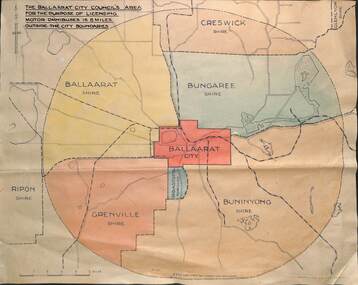
Drawing - Map, "Licensing motor omnibuses", c1940
... buses. Shows the boundary of the City of Ballaarat, Borough... buses. Shows the boundary of the City of Ballaarat, Borough ...The drawing or map shows the 8-mile radius that applied to the City of Ballaarat's powers for the licensing of passenger Motor buses. Shows the boundary of the City of Ballaarat, Borough of Sebastopol, Shires of Ballaarat, Bungaree, Buninyong, Creswick, Glenlyon, Grenville and Ripon. Demonstrates a plan that shows the limits of the City of Ballaarat's power to license passenger buses.Drawing - dyeline print and colouredbuses, licensing of buses, shires, maps, city of ballaarat