Showing 1938 items
matching flood
-
 Charlton Golden Grains Museum Inc
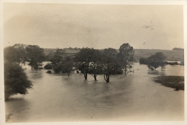
Photograph, Cameron, Ian, 1973 flooded Avoca River, Feb 19873
1973 flooded Avoca River. Viewed from west side of Paterson Bridge behind the shire office.B/W photograph of 1973 flooded Avoca River. View West side of Paterson Bridge behind Shire Officeflood, avoca river, charlton -
 Lake Bolac & District Historical Society
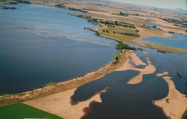
Colour photograph, Jan. Flood of Fiery Creek Inlet and Lake Bolac
January, 2011. Floodwaters entering Lake Bolac through the Fiery Creek inlet. This shows the accumulation of water behind the barrier dunes and the strength of the flood entering the lake through the narrow debouchment. The aboriginal midden can clearly be seen in the front left to centre of the photograph. Photograph courtesy James Davidson.lake bolac, fiery creek, 2011 flood, midden -
 Kew Historical Society Inc
Photograph - Kane's Bridge destroyed by the 1934 Flood, 1934
In 1928 a footbridge was erected to link Kew with the public golf course across the Yarra. The total cost of construction came to 250 pounds and the bridge became known as Kane's Bridge. During the 1934 floods the bridge was washed downstream, and was subsequently rebuilt. The present form of the bridge resembles the earlier bridge which crossed from the Yarra Bend Asylum to Kew, further upstream. (VHD)Black and white positive print (identical to 2021.70 but with a different annotation) showing the destruction of Kane's Bridge in the floods of 1934. The Kodak paper would indicate a 1950s reprinting.Annotation verso: "Kane's Bridge in 1934 flood / Dec. 1934.kane's bridge, river yarra, yarra valley, 1934 floods -
 Eltham District Historical Society Inc
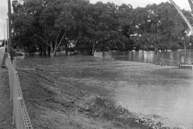
Photograph, Diamond Creek in flood over Glen Park Bridge, Eltham, c. 26 August 1924
Significant flooding of the Diamond Creek occurred in Eltham and Glen Park on Tuesday, August 26, 1924 with several houses swamped and all bridges covered except the Greensborough Road Bridge. [Houses at Eltham Flooded. (1924, August 27). The Argus (Melbourne, Vic. : 1848 - 1957), p. 19. Retrieved from http://nla.gov.au/nla.news-article4156891] The Glen Park Bridge was originally built as a replacement for an older private bridge built by a man named Foley around 1880. In 1911 Heidelberg and Eltham agreed to share the costs to build a new bridge. Construction began in June 1915 and it was officially opened by Cr. Taylor on Cup Day, November 1915. The bridge was destroyed by floodwaters in the afternoon of 20 September 1959 during construction of the new Wattletree Road bridge. The new bridge west embankment joined the existing road at approximately where the bend in the road is situated in the photograph.Colour photograph of originalfloods, eltham, diamond creek (creek), egan's crossing, eltham-diamond creek road, glen park bridge, glen park road -
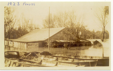 Kew Historical Society Inc
Photograph, Flooded Boat Shed in Kew, 1923, 1923
One of three digital copies of flooded areas of Kew (1923-34), donated by Jan Coutts of Bulleen in 2019. The handwriting on the originals predates the copy.1923 FLOODS / 14/10/1923 FLOODSfloods - kew - 1923 -
 Tatura Irrigation & Wartime Camps Museum
Newspaper cuttings, The Age, Queensland and Victoria Floods 2011, January 2011
9 cuttings from The Age newspaper, January 2011 regarding the Queensland and Victorian record floods.articles and photos of floodsqueensland floods, victoria floods -
 Kew Historical Society Inc
Photograph - Flooding of the Yarra Valley at Kew East, 1974
Flooding of the Yarra Valley, including that section of the Yarra bordering Kew and Kew East in the north and west of the municipality, was a regular occurrence. Extreme flood events of the Yarra River are recorded to have occurred in 1891, 1901, 1916, 1923 and 1934. The Municipality of Kew's response to these floods was to enact planning decisions restricting residential development in flood prone areas following the floods of 1916, 1921 and 1934. While floods continued after the development of the Upper Yarra Reservoir (construction 1948-57), the regularity and extent of these inundations diminished. During the nineteenth century, the land abutting the south side of the Yarra in Kew was devoted to dairy farming. In the twentieth century, before and after the construction of the Eastern Freeway, much of this low-lying area was used as golf courses and public parks.Late example of the capacity of the Yarra Valley at Kew to flood, even though drainage works and the Upper Yarra Reservoir had reduced their regularity.Original black and white print photograph of the low-lying land at East Kew under floodwater on 16 May 1974. The vantage point of the photographer is Lister Street. Flooding was caused by overflowing water in Glass' Creek and the River Yarra. Annotation verso: "Lister Street looking north / Flood level / 16 May 1974 11.30am / R.L. 46.04"hays paddock, floods, yarra river, glass' creek, lister street -
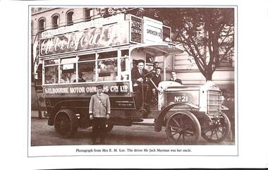 Melbourne Tram Museum
Photograph - Illustration/s, James Flood Charity Trust, c1920
Illustration of a Melbourne Motor Omnibus Co Ltd. Bus, No. 21, possibly at Spring St, on a bus route that operated via Bourke, Spencer and Collins St. Has the destination of Spencer St. The conductor is in a uniform. The bus operated by F. Leslie Bruford, of 352 Collins St. The bus has adverts for Hoyts Olympia and Abbotsford Ale. The buses ran in competition with the tram services. The illustration is part of an Order for the Book, Victoria Illustrated, published during 1984.trams, tramways, buses, collins st, bourke st, competition, bus 21 -
 Yarra Glen & District Historical Society
Black and white photographs, Flood waters in Yarra Glen December 1934
Black and white photograph of Bell street, Yarra Glen, taken in December 1934 from the tower of the Grand Hotel, looking south towards the railway crossing, during the floods. The Victoria Hall is the building in the centre of the photograph. Directly behind the Victoria Hall, the roof of 'River View' guest house can be seen. The Shell Garage, operated by Les Orenshaw, on the left of the photograph was originally built and occupied as a peg factory.The view extends from Bell street across the river flats with the high ground of Chateau Yering in the background. Bell Street is defined by the street trees where the water covers the road in the foreground grand hotel, victoria hall, bell street, floods 1934, 1934 flood, railway crossing, river view, guest house, shell garage, peg factory, river flats, chateau yering, les orenshaw, street trees -
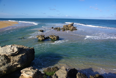
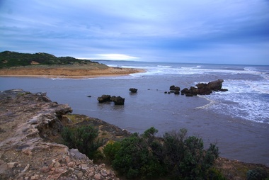 Ballarat Heritage Services
Digital photographs, L.J. Gervasoni, Hopkins River Mouth in flood as the waters receed, c2010 - 2017
Colour photograph of the mouth of the Hopkins River at Warrnambool,hopkins river, mouth, point ritchie, bluehole, warrnambool, coast, coastal, beach, seascape, flood, post flood, geology, coastal geomorphology, waters receeding -
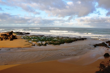
 Ballarat Heritage Services
Digital photographs, L.J. Gervasoni, Hopkins River Mouth in flood - waters receeding, c2010 - 2017
hopkins river, mouth, point ritchie, bluehole, warrnambool, coast, coastal, beach, seascape, flood, post flood, geology, coastal geomorphology, waters receeding -
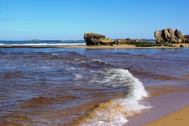 Ballarat Heritage Services
Digital photographs, L.J. Gervasoni, Hopkins River Mouth after the flood, c2010 - 2017
hopkins river, mouth, point ritchie, bluehole, warrnambool, coast, coastal, beach, seascape, flood, post flood, geology, coastal geomorphology, waters receeding -
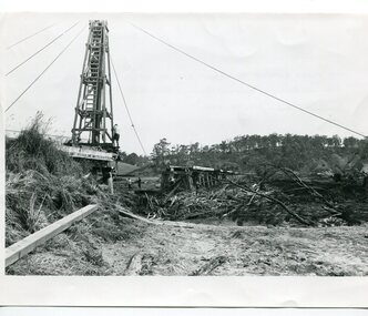 Orbost & District Historical Society
black and white photographs, 15th February 1971
The 1971 flood was the the worst flood on record. At Jarrahmond it was at least 11 metres and up to one and a half kilometres wide on the flats causing enormous damage to the flood plain. Records say that "The brown floodwater stain in Bass Strait could be seen from passing airliners." Considerable damage was done to railway infrastructure, roads and farms. More information from the APRIL, 2008 newsletter by John Phillips. (see orbosthistory.com.au) The railway line was destroyed and was not expected to be opened for a fortnight. Orbost was cut off by 50 square miles of Snowy River floodwater. These photographs are pictorial records of the 1971 floods which was a significant event in the history of Orbost. They are also associated with the East Gippsland Railway.Three black / white photographs of flood debris and flood waters near a railway line. 3102.l has a pile driver 3102.2 shows a gap in the viaduct and 3102.3 shows men with a tractor cleaning up the debris,3102.1 - on back - "1971 FLOOD REPAIRS TO ORBOST RAILWAY VIADUCT - 15th February 1971. Donated by Audrey Van Den Berg VRH 3693" 3102.2 - on back - " DAMAGE TO RAILWAY VIADUCT ACCUMULATED DEBRIS" 3102.3 - on back - "DAMAGE TO RAILWAY VIADUCT AT ORBOST. CLEAN UP BEGINS"orbost-flood-1971 orbost-viaduct-flood-damage orbost-railway -
 Ballarat Heritage Services
Digital photographs, L.J. Gervasoni, Hopkins River Mouth reef exposed after flood, c2010 - 2017
hopkins river, mouth, point ritchie, bluehole, warrnambool, coast, coastal, beach, seascape, flood, post flood, reef, exposed, geology, coastal geomorphology -
Glenelg Shire Council Cultural Collection
Postcard - Postcard - Casterton, Victoria, n.d
SOURCED FROM CASTERTON TOWN HALL (FORMER SHIRE OF GLENELG)Black and white photo postcard, taken from elevated position showing Casterton in flood 1906Back: '1906 flood' written in pencilcasterton, casterton flood, environment, weather -
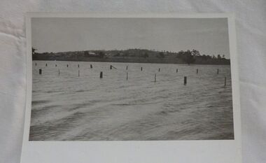
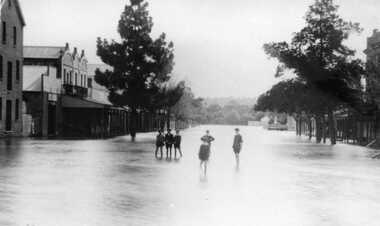 Charlton Golden Grains Museum Inc
Photograph, Aug 1909
1909 flood, High Street, Charlton Victoria. Children standing in floodwater in High Street looking west from corner of Armstrong Street. Malcolm's Flour Mill and Proctors Double story building.B/W photograph of 1909 flood. Children standing in floodwater in High Street looking West from Corner of Armstrong Street Charlton.flood, charlton, armstrong street, arm -
 Kew Historical Society Inc
Photograph, Floods in North Kew, 1934
The great flood of 1934 in Melbourne was one of the most devastating floods since records began. The floods affected all of Melbourne, including Kew.Locally significant photographs of the impact of flooding in Kew in 1934Floods in North Kew, 1934. Flood near Lagoon (Billabong?) Willsmere Road, North Kew.floods (kew) 1934, yarra river -
 Kew Historical Society Inc
Postcard - Flood, Glenferrie Road, Hawthorn, 1921
An item from an outstanding and diverse photographic collection, assembled by members of the Christian and Washfold families of Kew.Flood waters in Glenferrie Road. Shopkeeper and bystanders on pavement. Real photo postcard produced by Kodak, probably to a photo by Henry Christian. "Dec 1921 / Floods in Glenferrie Rd"glenferrie road -- hawthorn, floods -- hawthorn (vic.), christian-washfold collection -
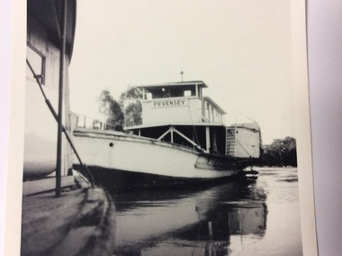 Port of Echuca
Black and white square photograph, 1974
This photograph shows the height of the river in the 1974 floods. The fence on top of the wharf can be seen the other side of the Pevensey. The height of the river can also be seen on the N.S.W bank. This photograph is significant because it shows the height of the river in the 1974 floods.This is a small square black and white photograph of the P.S Pevensey tied up to the Echuca wharf in the 1974 floods. The P.S Canberra is tied up in front of the Pevensey. A very small portion of the Canberra can be seen. On the front of the photograph the words Pevensey can be seen. On the back of the photograph hand written in ink are the words" Pevensey 1974 floods. Beside wharf. Canberra in foreground."1974 floods, flooding, p.s.pevensey, echuca wharf -
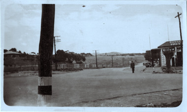 Kew Historical Society Inc
Photograph - Country road
Original, black and white positive print which the inscription on the reverse incorrectly claims is of Kew during the 1934 floods. The date may be 1934, but there is no evidence of flood waters or of location. The photo is of an intersection with a hotel on the corner in front of which a man is standing. The hotel would appear to be named Russell['s] Hotel. There is also an advertisement for Willys on the hotel verandah. Inscribed verso: "Yarra Floods Kew 1934" unidentified locations -
 Eltham District Historical Society Inc
Photograph, 1934 Floods at Eltham
Published in the Diamond Creek Basin Study, 1980 and identified at Diamond Creek, locality not identified, 1934. The location is actually looking south across the Diamond Creek towards Falkiner Street, beside the Main Road bridge at Eltham South from what is now part of Wingrove Park opposite Antoinette Boulevard. The bridge railing is just visible to the left of image. The large leaning Manna Gum beside the bridge still stands in 2021 alongside the Diamond Creek trail. In 1934 extensive flooding of the Yarra River and Diamond Creek set new records for flood plain level (Eltham Chronology, EDHS)Black and white photographCopied by Hugh Fisher, Photographer, 6 York Street Eltham A1678B Floods- Eltham - 1934floods, yarra river, eltham, flooding, diamond creek, flood -
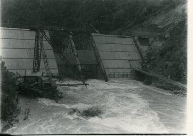 Kiewa Valley Historical Society
Photograph - Kiewa River in flood at Clover Dam
As part of the push to cut electricity costs and diversify supply, the Victorian Government (circa 1930) implemented the conversion strategy from mainly brown coal supply to hydro - electricity. The Kiewa Hydroelectric Scheme became the largest scheme of its kind in the State Of Victoria and the second largest scheme in Australia. Clover Dam and Power Station were built by the State Electricity Commission of Victoria as part of the Kiewa Hydro Electric Scheme from the late 1930's to the early 1940's. This dam was constructed to supply water to feed four turbines (62 mega watts) at the West Kiewa Power Station. This was at the forefront of sustainable "Green" energy. Costs associated with power supplies is still a major incentive of governments, however environmentally friendly alternatives such as wind and nuclear have also made inroads. The Kiewa valley and its surrounding alpine catchment were looked at(Victorian State Government), from the beginning of the twentieth century as a source of alternate power for an ever-increasing demand for electricity by growing population and heavy industrial areas within Melbourne City and State regions. Construction of dams, such as Clover Dam provided the large quantity holding areas of water required to turn the turbines at the various power stations to provide the electricity needed. The impact of these controls by moderating water run-off from the alpine regions is beneficial in reducing flooding from thawing of snow on the alps. This by-product allows agriculture and grazing to be less vulnerable to seasonal flooding thereby resulting in a more stable annual production level.Black and white photograph of Clover Dam with Kiewa River in flood. .5mm white boarder on 3 sides of photo.Handwritten on back of photograph in black pen - Kiewa in flood. Clover Dam.clover dam, secv -
 Bendigo Historical Society Inc.
Newspaper - LYDIA CHANCELLOR COLLECTION: MAJOR T. FLOOD SPEAKS
A small black cardboard box with a red rose on the lid containing newspaper clippings of Cr. Tom Flood's column from 'The Bendigo Advertiser titled, 'Mayor Speaks.' 1966,67.Mayor T. Flood Speaks 1966, 1967newspaper, bendigo advertiser, major speaks, lydia chancellor, collection, newspaper, mayor t. flood, cr. flood, 'mayor speaks, ' 'the bendigo advertiser, ' bendigo -
 Port of Echuca
A black and white photographic postcard, Between 08/1906 - 10/1906
Photographic Postcards were very popular in the early 20th century and this shows the Campaspe river, Echuca in flood. The high water mark is exemplified by having the rower on the water. The water has inundated the surrounding bush with trees partly submerged along the right hand side of the photograph.Rowing clubs were popular in towns along the Murray river and this picturesque scene of the Campaspe river , Echuca in flood shows a man rowing a racing scull down the river.Black and white photographic postcard showing the Campaspe river, Echuca, in flood, with a man rowing a racing scull.On face : "Campaspe River, Echuca". On reverse: printed in ink :" Post Card. This space may be used for correspondence. For address only. Place penny stamp here." In pencil is written: "Aug Sep Oct 1906 Flood" "Donation H V Evans 85 Fullers Rd Chatswood NSW." " Echuca Regional Library" is stamped but has been crossed out in pen.campaspe river, echuca, echuca flood, 1906, rowing, echuca -
 Wycheproof & District Historical Society Inc.
Photograph, Mr Ernie Taylor, Cooroopajerrup Creek 1923, 1923 (exact)
The semi-mythical stream, the Cooroopajerrup Creek. Before there were any channel banks and formed roads, this creek shared the Avoca flood waters with the Tyrrell Creek. In more recent times the Wycheproof channel prevented the major floods of 1956 and 1973 from following the old river course. Also there is said to have been some shifting of the sand-hills at Teddywaddy which have blocked much of the old Cooroopajerrup flow. Little is known of earlier records, but The Mount Wycheproof Ensign records flooding of the creek in 1909. 2011 saw the Cooroopajerrup flow again after 88 years. This 2011 photo was taken at about the same position as the 1923 photo. The modern steel roadway fence is submerged. see-Photograph-Record No 001997.Copy of a B&W photograph of the Cooroopajerrup-Creek in flood-1923. To the north is Mount-Wycheproof, with the hospital barely visible behind the trees just left of centre, and a few scattered dwellings. The nearer railway-fence follows the road leading to the current saleyards.The outer fence has been replaced with a modern steel fence.None1923, cooroopajerrup creek, flood, mount wycheproof -
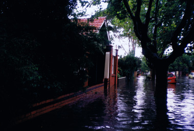
 St Kilda Historical Society
Photograph, Elwood floods 1989 - images collection, 7/02/1989
Glenhuntly Rd floods, February 1989colour photograph unmountedGlenhuntly Road floods Feb 89glenhuntly road, floods, 1989, elwood college, elwood secondary college, elwood -
 Kew Historical Society Inc
Photograph, Floods in North Kew, 1934
Living with natural processes was frequently a challenge to early European settlers and later residents of what was in the 1850s administered by the Borondara Road Board. This was compounded by the area being bounded on three sides by rivers (Yarra River, Koonung Creek and Gardiner's Creek). In 1849, the historian James Bonwick recorded that "our district [Kew] suffered considerably. Mr Wade speaks of 80 acres, out of 100 acres of his cultivated paddock, covered by water." Newspapers continued to describe major flooding in Kew in 1863, 1869, 1878, 1880, 1889, 1891, 1916 and 1934. While the construction of the Upper Yarra dam in 1957 reduced the levels of flowing downstream, local and riverine floods continue.The Kew Historical Society's pictures and map collections testify to the impact of flooding in the district. They have historical importance in documenting the extent of flooding in the district and its affects on homes, services and recreation. Numerous photographs record flooding throughout the Twentieth Century.Floods in North Kew, 1934. Flood near the lagoon (Billabong?)floods (kew) 1934, yarra river -
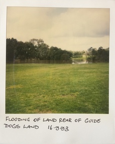 Kew Historical Society Inc
Photograph - Flooding at parkland at rear of Guide Dogs Victoria, 1993
The land currently occupied by Guide Dogs Victoria was once part of the grounds of the Kew Lunatic Asylum. This includes the land, designated as parkland which adjoins the Yarra River. It is now designated as the Chandler Park.Original colour small format polaroid photograph of flooding in parkland at the rear of Guide Dogs Victoria in the area now used as the Main Yarra Trail; taken on 16 September 1993."Flooding of land rear of Guide Dogs land 16.9.93"yarra river -- floods -- kew (vic.), guide dogs victoria, main yarra trail, chandler park -
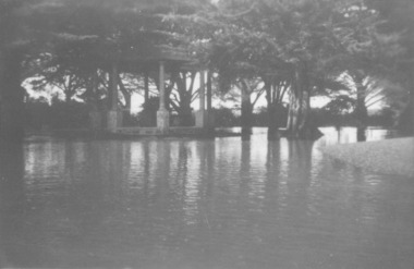 Port Fairy Historical Society Museum and Archives
Photograph
Showing the flood waters of 1946 around the Band Rotunda in the botanical gardens. Funding for the construction of the Rotunda was bequeathed in the Will of local resident Mrs Annie Williams, who was born in Daylesford in 1872 and died in Kew in 1930. Annie’s Will stipulated that the remaining value of her Estate be spent on erecting a Bandstand in the Port Fairy Botanical Gardens dedicated to the memory of her brother Hugh, a stretcher bearer in WW1 and who died in 1921 after being discharged with health issues, her husband Henry, and herself naturally. There is a plaque dedicated to Annie on the Bandstand She requested that the Bandstand be a replica of the one at Daylesford but by 1933 the value of her Estate had diminished to £76.4/8 which was insufficient to cover a similar design and the Borough Councillors felt it would be too extravagant for the Port Fairy Botanical Gardens. Local builder J.J.McLaren’s tender of £71.15/- was accepted and the octagonal concrete pillared construction was completed with the use of sustenance labour the following year. The Bandstand was opened in December, 1934 with a performance by the Port Fairy Band and local residents enjoying the entertainment and a picnic. In 1934 it was reported that there was some fuss in Council because of the whereabouts of the sum of approximately £3/- , being the amount left over from the build. After some months of debate, in which the Councillors suggested that the Engineer had used the money inappropriately, and to which he responded that the build had cost more than the quote, the matter seems to have ended there An image of the flood waters in the botanical gardens in 1946Black and white photograph of Flood water around rotunda in the gardensflood, river, botanical gardens, port fairy, moyne river, rotunda, bandstand -
 St Kilda Historical Society
Photograph, St Kilda floods, 23 January 1991 - images collection, 23/01/1991
Heavy rains caused flooding in the Port Phillip area on 23 January 1991, including in St Kilda. The level of Elster Creek, Elsternwick, rose to 2.54m (from normal level of 0.1m) and there was historically high flooding along Elwood CanalColour photographFlood 23/1/91 9.30amst kilda, flood 1991, 23 january 1991, 23/01/91