Showing 1796 items
matching lake street
-
 Lakes Entrance Regional Historical Society (operating as Lakes Entrance History Centre & Museum)
Photograph, Holding M, 2009
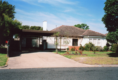
... , at 20 Devitt Street Lakes Entrance Victoria... of sash windows, at 20 Devitt Street Lakes Entrance Victoria ...Dr Robert Hughes had a well set up surgery in what may have been originally a garage beside the family home, during 1970 - 1980's. Later resident converted surgery to a flat.Colour photograph of a timber dwelling with tiled hip roof. Brick chimney has been cement rendered. Windows on each side of central front entry have pictured window in centre of sash windows, at 20 Devitt Street Lakes Entrance Victoriahouses, heritage study -
 Lakes Entrance Regional Historical Society (operating as Lakes Entrance History Centre & Museum)
Photograph, Lakes Post Newspaper, 7/10/1991 12:00:00 AM
... of Patties Lakes Cycling Tour organised by Frank Daly, shows cyclists...Lakes Entrance Regional Historical Society (operating ...Another black and white photograph taken of final stages of Porters Lakes cycling tour looking toward Mourlyan Street corner number 04027.1 size 18 x 22.5 cmBlack and white photograph taken at the final stage of Patties Lakes Cycling Tour organised by Frank Daly, shows cyclists approaching and crossing the finish line with many bystanders at Stock Street and Maurilyan Street intersections, Roadknight Street Lakes Entrance Victoriasports -
 Lakes Entrance Regional Historical Society (operating as Lakes Entrance History Centre & Museum)
Photograph, Lakes Post Newspaper, 1/12/1995 12:00:00 AM
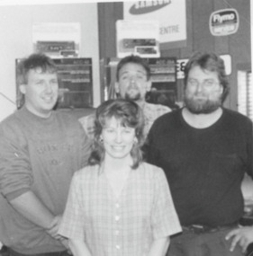
... Appliance Centre Whiter Street Lakes Entrance Victoria. Also... and Christine Porter of Mascot TV Appliance Centre Whiter Street Lakes ...Black and white photograph of staff member Darren Truscott, Geoff Porter, Dale Coleman and Christine Porter of Mascot TV Appliance Centre Whiter Street Lakes Entrance Victoria. Also a second photo of Mascot Tv van with Darryn Trescott 1994businesses, people, retail -
 Rutherglen Historical Society
Image, 1938 (Exact)
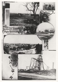
... of Rutherglen. Photos include: view across a vineyard, swans in Lake...Rutherglen Historical Society Murray Street Rutherglen high ...Black and white postcard with the title "The Season's Greeting From Rutherglen", illustrated with photographic views of Rutherglen. Photos include: view across a vineyard, swans in Lake King, a street view, Great Southern Mine, and Garibaldi Mine. This one is an enlarged photographic duplicate of 449.10a rutherglen, vineyard, great southern, garibaldi mine -
 Lakes Entrance Regional Historical Society (operating as Lakes Entrance History Centre & Museum)
Photograph, Holding M, 1999
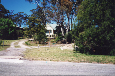
... vegetation, at 6 Worcester Street, Lakes Entrance Victoria... vegetation, at 6 Worcester Street, Lakes Entrance Victoria Photograph ...Appears to have been relocated from unknown site, more research required.Colour photograph of a timber dwelling. Has high pitched corrugated iron roof, decorative timber frieze under pitch of gable over front room. Steps leading up to veranda. Set in native vegetation, at 6 Worcester Street, Lakes Entrance Victoriaaccommodation, houses, heritage study -
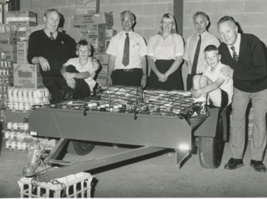
Lakes Entrance Regional Historical Society (operating as Lakes Entrance History Centre & Museum)
Photograph, Lakes Post Newspaper, 1/04/2008 12:00:00 AM
... Jackson in photograph at Bowls Clubrooms Rowe Street Lakes... Clubrooms Rowe Street Lakes Entrance Victoria Photograph Lakes Post ...Colour photograph of Lakes Entrance Bowls Club President Linsay Wangman presenting LERHS President Marie Fish with cheque for $500 from the Wrong Bias account with Wendy Price and Trevor Jackson in photograph at Bowls Clubrooms Rowe Street Lakes Entrance Victoriahistorical society -
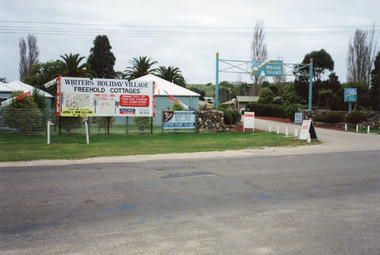 Lakes Entrance Regional Historical Society (operating as Lakes Entrance History Centre & Museum)
Photograph, Holding M, 1994c
... Street, Lakes Entrance, Victoria, developed on the site... Village, Whiters Street, Lakes Entrance, Victoria, developed ...Colour photograph of Whiters Holiday Village, Whiters Street, Lakes Entrance, Victoria, developed on the site that was known as Whiters Camp Park. Shows the entry to the complex between stone fences, advertising boards on fence line, glimpse of cottages and mature trees inside the grounds.tourism, resort, fences -
 Eltham District Historical Society Inc
Slide, Construction of Eltham Town Park, 22 Feb 1974
... and Bridge Street. The lake body has been formed and young trees... and Bridge Street. The lake body has been formed and young trees ...Construction of Eltham Town Park, later renamed Alistair Knox Park. View looking towards the intersection of Main Road and Bridge Street. The lake body has been formed and young trees planted.35 mm colour positive transparency Mount - Agfacolor Service (Blue)alistair knox park, eltham town park, bridge street, main road -
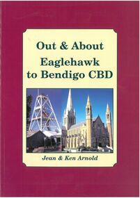 Bendigo Historical Society Inc.
Book - Out & About Eaglehawk to Bendigo CBD
... north east to Nolan Street past Lake Weroona then along... east to Nolan Street past Lake Weroona then along the railway ...This book covers the Bendigo CBD area from Valentine street north east to Nolan Street past Lake Weroona then along the railway line before turning west roughly following Violet Street. Burgundy Outline with Cream Insert with photos of Cathedral and Central Deborah Mine. Rear Cover Canterbury Park Eaglehawk and photos of Rosalind Park - Authors Jean and Ken Arnold - 88 Pagesplaques, monuments -
Lakes Entrance Regional Historical Society (operating as Lakes Entrance History Centre & Museum)
Photograph, 1944 c
... Street Lakes Entrance Victoria... and other necessary buildings, looking east from Myers Street Lakes ...Construction commenced 1942 concluded 1947 250,000 gallons of oil produced from shaftBlack and white photograph of Lakes Oil Limited Company's Deep Shaft production field, image shows derrick over pilot bore headframe over main shaft engineroom, storage tanks, offices and other necessary buildings, looking east from Myers Street Lakes Entrance Victoriaoil and gas industry -
 Lakes Entrance Regional Historical Society (operating as Lakes Entrance History Centre & Museum)
Photograph, 2000
... age. Situated at 90 Carpenter Street, Lakes Entrance.... age. Situated at 90 Carpenter Street, Lakes Entrance ...House built 1911 for James Carpenter as family home. Original front lawn of violets was venue for Violet Picking Days, around 1920 and 1930. Exterior now aluminium cladding. Occupied by Mac and Margo Kerby, pharmicists, 1960's to early 1980's. Ian Daniel 1990's. Name of house 'Corumbene'|Also One Colour photograph of front fence. 02442.1Colour photograph of a substantial weatherboard triple fronted Californian Bungalow. Bull nose veranda returns around angle to side main decorative timber frieze under veranda roof. Two cypress trees and one Norfolk Island Pine of significant age. Situated at 90 Carpenter Street, Lakes Entrance.houses, heritage study -
 Lakes Entrance Regional Historical Society (operating as Lakes Entrance History Centre & Museum)
Photograph - Foodarama Supermarket Lakes Entrance, Lakes Post Newspaper, 1/02/1996 12:00:00 AM
... Frank, Peter, Sam and Dom of Lakes Foodarama Supermarket Myers...Foodarama Supermarket Lakes Entrance Businesses Commerce ...Foodarama Supermarket Lakes Entrance Black and white photograph of four Berlingeri brothers Frank, Peter, Sam and Dom of Lakes Foodarama Supermarket Myers Street with winner of $1000 goods raffle Karen Rosenboom and sons Dian and Mark Lakes Entrance Victoriabusinesses, commerce, supermarkets -
 Lakes Entrance Regional Historical Society (operating as Lakes Entrance History Centre & Museum)
Photograph, Lakes Post Newspaper, 1992
... Weather Station Myers Street Lakes Entrance... Weather Station Myers Street Lakes Entrance Photograph Lakes Post ...Black and white photograph of a group of people Peter Dawson Weather Bureau Inspector for Victoria, Graham Duff Regional Operations Manager for Weather Bureau, Barbara and Frank Ray, Tony Langiano taken on the occasion of the retirement of Barbara Ray after 27 years at the Victorian Bureau of Meteorology Weather Station Myers Street Lakes Entrancegenealogy -
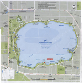 Ballarat Tramway Museum
Map, City of Ballaarat, Lake Wendouree, 2010
... Colour printed map of Lake Wendouree and surrounding... Parade Ballarat Ballarat goldfields Trams tramways Map Lake ...Colour printed map of Lake Wendouree and surrounding streets showing walking paths, roads, tram, bus and rail lines and other features. Used in the large maps placed around the Lake c2009. Printed on an A3 size sheet. Two copies held.trams, tramways, map, lake wendouree, wendouree parade -
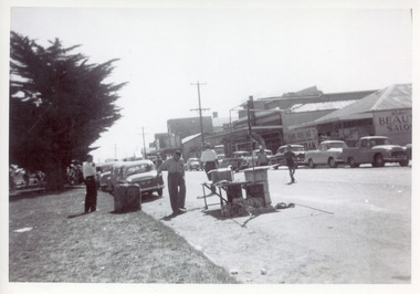 Lakes Entrance Regional Historical Society (operating as Lakes Entrance History Centre & Museum)
Photograph, 1950c
... a street celebration. Lakes Entrance Victoria... of road seemingly in preparation for, or remaining after a street ...Black and white photograph of a section of Esplanade. In view are the Maranui Motel, Catalina Cafe, Bulmers Gift Shop, Bill's hairdresser. Cypress trees on grassy verge on south side of highway. 44 gallon drum, trestle table and frame for shelter on edge of road seemingly in preparation for, or remaining after a street celebration. Lakes Entrance Victoriamemorials, township, celebrations, retail trade -
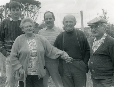
Lakes Entrance Regional Historical Society (operating as Lakes Entrance History Centre & Museum)
Photograph, Anne Macarthur, 9/10/2010 12:00:00 AM
... the building moved to Church Street Lakes Entrance. It was a home... the building moved to Church Street Lakes Entrance. It was a home ...Also eight more colour photographs taken of same house showing various aspects of building. 05007.1, .2, .3, .4, .5, .6, .7, .8 The old Church House served the Bruthen community in 1880s when no longer required it was barged to the New Works area where it became Church and meeting hall. By the time the Entrance work was completed the contractor J R Coate had the building moved to Church Street Lakes Entrance. It was a home for various local families until abandoned then acquired by Val Northrope. After renovation by Val in Lakes Entrance it was moved again to a site beside the Northropes new home near Bruthen.Colour photograph of timber cottage surrounded by picket fence four women at gateway. Cottage situated near Bruthen Victoriahouses -
 Lakes Entrance Regional Historical Society (operating as Lakes Entrance History Centre & Museum)
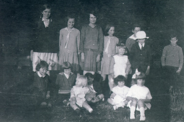
Photograph, 1920 c
... Jemmeson, Roadknight Streets neighbourhood Lakes Entrance Victoria...Lakes Entrance Regional Historical Society (operating ...Black and white photograph of a group of children all neatly dressed for a special occasion. Boy in white hat is Rex Fish, Little girl in front with ribbon is June Fish, next to June is Dorothy Jemmeson, top left back row is Maisie Ault, boy on far right is Oscar Hammarstrom, appear to be families from Jemmeson, Roadknight Streets neighbourhood Lakes Entrance Victoriagenealogy, clothing, guide group -
 Federation University Historical Collection
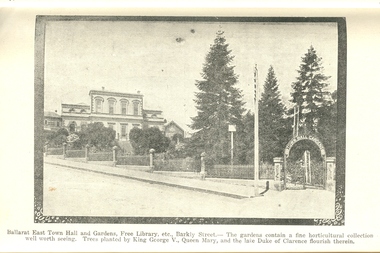
Book, Guide to Ballarat the Beautiful, 1923, 1923
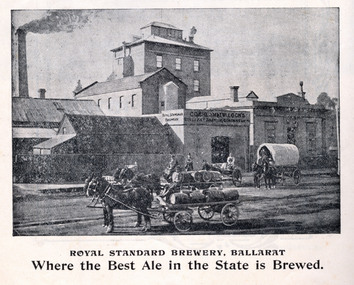
... Stockade, Lake Wendouree, South Street, Grand National Eisteddfod... Stockade, Lake Wendouree, South Street, Grand National Eisteddfod ...The image of Ballarat Trustees relates to a building on the corner of Mair and Lydiard Streets. In 2010 it was used as Cuthberts law firm.Grey/green soft covered book. Includes photographs and map. Themes include: Ballarat History pre gold, mining, Eureka Stockade, Lake Wendouree, South Street, Grand National Eisteddfod of Australasia, schools, Black Hill, Lake Burrumbeet, Creswick, Buninyong. Illustrations and advertisement include: Sturt Street,James Smith, Ballarat Town Hall, Ballarat East Town Hall, Rowlands, Ballarat brewing Co., Royal Standard Brewery, steam train, Lake Wendouree, J.S. Vickery & Son, trout, Berry, Anderson & co., Ballarat Botanical Gardens and hot houses, Claxton Memorial Fountain, statues, New Imperial Gold Mine, Art Gallery of Ballarat, St Patrick's College, Ballarat Grammar School, Ballarat School of Mines, Ballarat College, Sunnyside Woollen Mills, Ballarat Agricultural High School, Passenger Steamer on Lake Wendouree, Moorabool Falls, Lal Lal Falls, Grosvenor Square, Netherby, Buninyong, Ballarat Motor Garage.ballarat, cuthberts, ballarat trustees, sturt street, tram, trams, ballarat town hall, crag's hotel, sun foundry, eureka aerated waters and brewing co, d. lem, chinese practioner, chinese herbalist, hugh v. mckay, sunshine harvester, gordon brothers, central business college, george hotel, edwards pyrites furnace, long's biscuits, ballarat eisteddfod, george farmer, ballarat botanical gardens, eureka stockade, lake wendouree, ballarat school of mines, moorabool falls, kirks reservoir, ballarat post office, hepburn lagoon, star of the east mine, emu river, ballarat observatory, statues, angus' rialto cafe, carlyon's hotel, clarendon ladies' college, j.e, sang, ballarat coffee palace, stansfield and smith, ballaray brewing company, phoenix brewery, rotal standard brewery, john macleod co, robert sim and co, cobb and co\eagle foundry, j.j. goller and co., mt buninyong lookout, ballarat town hall ballarat east gardens, hot house, glass house, statuary pavilion new imperial gold mining co.,, art gallery of ballarat, st patrick's college, ballarat agricultural high school, lake wendouree steamer, grass trees at mt clear, mount clear, lake burrumbeet, newlyn reservoir trout, lal lal falls, grosvenor square, netherby, ramelli's motor garage, buninyong gold obelisk, memorial, imperial gold mine, botanical gardens lily pond and fernery -
 Ballarat Tramway Museum
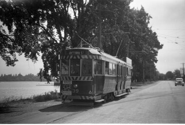
Photograph - Black and White photocopy, Travis Jeffrey, 1961
... at Civil hall on front of tram. Showing Victoria Street... dancing at Civil hall on front of tram. Showing Victoria Street ...Negative No. N387 and black and white print made by a laser printer (stored in folder) of Ballarat No. 39 passing depot junction, in 1961. Tram fitted with lights and small white stripe. Small triangles in corners of front dash. Ad for 60/40 dancing at Civil hall on front of tram. Showing Victoria Street destination. Lake in background, no other vehicles. Photo by Travis Jeffrey, who advised could be Dave Kellett driving. Date of photo on folder 5/9/1960. Date of photo could be incorrect, due to fitting of lights taking place late 1960. Large print of this photo made for display 1995c. Item updated when negative added to collection - 1/6/2003. Original negative rescanned 24/5/2020 and image file updated. Paper print of original photo in folder 73.Paper folder that contained the negative had "NR40A" in red ink, "BA14" in pencil, date stamp of "5 Sep 1960" on front, and on rear date stamps "26 Sep 1962" and "6 Oct 1962".trams, tramways, ballarat, wendouree parade, tram 39 -
 Federation University Historical Collection
Book, Powell & Co, Guide to Ballarat the Beautiful, 1906, 1906
... , South Street, Grand National Eisteddfod of Australia, Lake View...., George Farmer, Sturt Street (colour), Lake Wendouree, Ballarat ...A book highlighting Ballarat and surrounds for visiting tourists. Green, black and red soft covered book of 50 pages. The book includes many illustrations and advertisements. Themes of the book include: Ballarat and district, Lake Wendouree, Ballarat Botanical Gardens, Statues, gold and mining, Ballarat gold nuggets, Eureka Stockade, Ballarat School of Mines, Hepburn Lagoon, Emu River, race courses, Art gallery of Ballarat Advertisements include: Dr Lem Chinese Practictioner, Eureka Aerated Waters & Brewing Co., Sunshine Harvester, Gordon Bros., Long's biscuits, South Street, Grand National Eisteddfod of Australia, Lake View Hotel, Carlyon's Hotel, Clarendon Ladies' College, J.E. Sang Chinese Doctor and Herbalist, Reid's Ballarat Coffee Palace, Robert Sim & Co Timber Merchants, Cobb & C0 livery and stables Ballarat, Eagle Foundry, Fred A. Reed Tobacconist, Heinz bros butchers, J.J. Goller & Co. Illustrations include: Craig's Royal Hotel, McBride's Boots, John Lavis Cordial Manufacturer, R. Graham & Sons tanners, Lester's hotel, Sun Foundry, Central business College, Edwards Pyrites & Ore Reduction Co., George Farmer, Sturt Street (colour), Lake Wendouree, Ballarat East Town Hall, Lake Burrumbeet, Queen Victoria Statue, Fairy Land, Ballarat Botanical Gardens, Lal Lal Falls, Moorabool Falls, Kirks Dam, Lake Wendouree and paddle boat, Lydiard Street, Bopeep Creek, Star of the East Mine, Peter Lalor Statue, great Equatorial Telescopu at Oddie Observatory (Ballarat Observatory), Boer War monument, Entrance to Art Gallery of Ballarat, interior of Art Gallery of Ballarat, Old Curiosity Shop, Angus Rialto cafe, Ballarat Brewing Co, Royal Standard brwery, Phoenix Brewery Warrenheip, John MacLeod and Companyballarat, ballarat school of mines, buninyong, burrumbeet, cobb and co, eureka brewery, ballarat brewing co, sturt street, m1604, chinese, chinese medicine, d. lem, j.e. sang, brewery, tanners -
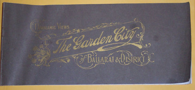 Ballarat Tramway Museum
Book, Berry Anderson Co, "Panoramic Views , The Garden City, of Ballarat & District", c1920s
... , Eureka Stockade, Lake Wendouree, Gardens, Ballarat and District..., Eureka Stockade, Lake Wendouree, Gardens, Ballarat and District ...Thirty two pages on gloss white paper plus brown covers, centre stapled, titled ""Panoramic Views , The Garden City, of Ballarat & District" in Gold printing. On rear has name of printers "Berry and Anderson Co Subtitle on page 1, "The Garden City being a series of 40 magnificent Panoramic Views of Ballarat and District, with special descriptive article, "Ballarat Revisited". On page 1, comprises a list of photos and a photo of Sturt St. looking east with an electric tram hauling a trailer. Pages 2 and 3 comprise the article. Most small photos are recycled postcard photos, dating from around the time of horse trams, through to the 1920, featuring the Arch of Victory, A number of photos of buildings such as Orphan Asylum, or Orphanage, Eureka Stockade, Lake Wendouree, Gardens, Ballarat and District Hospital, The Gardens and Reservoirs or Lakes. Many of the street scenes in Sturt St, feature tram in the City area - see the 11 image files including some close detail scans or horse trams turning from Sturt St to Lydiard St while one horse tram is coming up the hill on the same side of Sturt St. Features both electric and some horse trams. Many photos have marks or ID marks in bottom corners - "PS x Co" and "H.J.S" See email from Alan Bradley - in worksheet file re notes on photos. Purchased on eBay from Pametna McGuire of Mt Eliza on 17/1/200 for $30.55 + postage. See worksheet file for details. For image i5, see also Reg Item 5907 for a postcard view. PDF scan version added 21/5/2019 - see image btm3278i.pdf See email from Alan Bradley of 9/4/06 re notes on the photographs. trams, tramways, ballarat, horse trams, esco, sturt st -
 Federation University Historical Collection
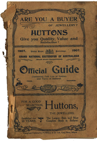
Book - Programme, South Street Eisteddfod Official Guide, 1907, 1907
... , Frederick Bevan, Ballarat (Sturt Street), Lake Wendouree (Yachts... Bevan, Ballarat (Sturt Street), Lake Wendouree (Yachts), J.W ...South Street competitions have been held in Ballarat since 1991.Official guide to the 1907 South Street competitions. Images include: Prince of Wales, Lord Northcote, W.D. Thomas, South Street Competition Executive Committee (W.H. Pearson, W.H. Chandler, A. Prichard, W.H. Richards, W.D. Hill, Col. Williams, W.D. Thomas, F. Besemeres, F.J. Martell, J.T. Morris. F.J. Williams, R. Maddern, R.J. Gribble), Sir John Madden, Lord Tennyson, W.D. Hill, Frederick Bevan, Ballarat (Sturt Street), Lake Wendouree (Yachts), J.W. Beswick, Lawrence Campbell, City of Ballarat Mayor and Councillor (Mayor Brawn, E. Williams, E. Morey. Cr Brokenshire, J. Whykes, J.M. Barker, G. Crocker, W.D. Hill, R. Pearse, T. Hollway), Ballarat East Mayor and Councillors (J. Gent, Cr Glendenning, J.N. Dunn, I. Pearce, C. Bunting, A. Levy, J. Ritchie, J. McNeil, A. McKenzie, Cr Penhalluriak), Sturt Street Looking West, Old Curiosity House, Entrance to the Ballarat Fine Art Gallery, Interior of the Ballarat Fine Art Gallery, Ballarat East Town Hall and Gardens, Lake Wendouree Ferry, W.E. Swenson, S.B. Swenson, J.G.M. Swenson, Rev. T. Flynn, Edwards' Pyrites, Lestor's Hotel, Sunshine Sheild, W to W Shield, Frank Herman, W.F. Coultman, Marks' Trophy, Lighthouse Port Fairy, R. Correll Music Seller, James Smith, Isaac Pitman, Arthur Brumfield, Hugh Leschen, John Robson, St Augustine's Band Geelong, Moorabool Falls, Kirks Dam, Ballarat Choral Society, Alfred Deakin, James Long, Hugh McKay Advertisements include: Huttons the Jewellers, Sam Jamieson, Sun Foundry, City Saw Mills, Blomeley Bros Iron and Brass Founders, G. Bongiorno- Railway Fruit Palace, Henry Brind & Co., Andrew Cant, Harrison's Foundry, Umbrella and Sunshade Emporium, Ballarat City Baths, Ballarat Coffee Palace, Irwin's Provincial Hotel, Victa Studio; D. Lem Chinese Medical Practitioner, Bosisto's Eucalyptus Oil, Ronaldson Bros & Tippett, Unicorn HOtel, Mrs F. Allen Caterer, Coles & Pullum, J.C. Dillon & Co., Surrey Tannery, Coulthard's Ballarat Business College, George Farmer, MrBride's Boots, L.J. Austin, Dyason's, Ballarat Brewing Company, Phoenix Brewery, Royal Standard Brewery, Edwards' Pyrites, Lestor's Hotel, Robson's College of Music, James A. Gear, Williams Shoemen, Tekardo Brothers, Powell & Co.south street competitions, eisteddfod, chinese herbalist, south street, r.b. lemmon, g. bongiorno, w.d. thomas, john madden, lord tennyson, w.d. hill, frederick bevan, j.w. beswick, lawrence campbell, boer war memorial, queen victoria statue, curiosity shop, m.b. john foundry, ballarat east town hall and gardens, sunshine shield, hugh victor mckay, w to w shield, w.j. coltman, frank herman, j. hutton-jones, t. downer, j. marks, hutton and co trophy, marks trophy, hugh leschen, john robson, st augustine's band, geelong, downer trophy, trekardo brothers, moorabool falls, kirks dam, ballarat choral society, alfred deakin, challenge cup, james long, grand national eisteddfod of australasia, ballarat east gardens, ballarat east town hall -
 The Beechworth Burke Museum
Photograph, est. 1860-1875
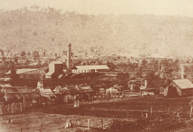
In 1875, the Rocky Mountain Extended Gold Sluicing Company Ltd was created, utilising the previous Rocky Mountain claim for the area near Lake Sambell. The company employed A.L Martin to survey an area for a tunnel underneath Beechworth and Johnson Stephens to dig it. The tunnel was built at a rate of 40 feet a month and eventually measured 800 metres. The tunnel was a true accomplishment both in the present and during the 19th century. It was considered to be a marvelous engineering feat. Beechworth is renowned for its hydraulic sluice method of mining. This involved soil being exposed to torrents of water from high-pressure hoses. From 1876 until its closure in 1921, the mine produced an astounding 47,926 ozs of gold. Companies like this were the source of income for many Chinese gold-diggers who sought to make their fortune on the goldfields of Beechworth. During the height of the rush, the town had around 7,000 Chinese inhabitants living on the outskirts of town as they were not permitted to live within Beechworth itself.The search for gold is ingrained into the history of Victoria and therefore, images like this one which portrays an open-cut sluicing site can reveal important information for society and technology for the date when the photograph was taken. This image is of important historical significance for its ability to convey information about sluicing and the methods used to find gold in 1910. It also shows a location where sluicing was undertaken which provides insight into the impact of sluicing on the environment at a time when it was done. This image of the Rocky Mountain mine is historically significant as the mining complex is now non-existent, with the only remains being the tunnel built in 1880 by the company, which was considered one of the greatest engineering feats of the time. The image also provides a first-hand look into the social and cultural networks at play during the 19th century with racial segregation of the Chinese at the 'Chinese Camp', as well as an insight into Beechworth's origins during the Gold Rush.A sepia rectangular photograph printed on matte photographic paper as a postcardReverse: Historic Beechworth / 7792.1 / ROCKY MOUNTAIN MINE / Viewed from the “Chinese Camp”, shown partly in the foreground, we see the central plant of the famous Rocky Mountain Mining Company. This extensive complex, of which nothing remains, was situated between Silver Creek and the present Lake Sambell area. The company was responsible for a tunnel cut through solid bedrock underneath the town of Beechworth and surfacing near the keystone bridge on the Wangaratta side. Completed in 1880 it was declared to be one of the greatest engineering feats in Australia. The tunnel is still basically intact today. / Series by Wooragee Graphics: Historic Beechworth. / COPYRIGHT BURKE MUSEUM / No.72 beechworth, rocky mountain mine, sluicing, gold rush, mining, gold -
 The Beechworth Burke Museum
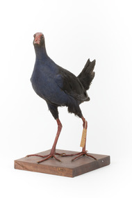
Animal specimen - Purple Swamphen, Trustees of the Australian Museum, 1860-1880
The Purple Swamphen can be readily located across eastern and northern Australia. They reside in areas with water including ponds, lakes, storm water drains, wetlands, swamps and marshes. These birds can often seen in urban locations including parks or along roadsides after a period of rainfall. Due to their adaptability, these birds often change environments. Purple Swamphens are omnivores and eat a wide variety of plants and animals. They live in large family groups and lay an average of five eggs which are the shared responsibility of both parents and occasionally the responsibility of young from a previous brood who may also assist caring for the eggs. This specimen is part of a collection of almost 200 animal specimens that were originally acquired as skins from various institutions across Australia, including the Australian Museum in Sydney and the National Museum of Victoria (known as Museums Victoria since 1983), as well as individuals such as amateur anthropologist Reynell Eveleigh Johns between 1860-1880. These skins were then mounted by members of the Burke Museum Committee and put-on display in the formal space of the Museum’s original exhibition hall where they continue to be on display. This display of taxidermy mounts initially served to instruct visitors to the Burke Museum of the natural world around them, today it serves as an insight into the collecting habits of the 19th century.This specimen is part of a significant and rare taxidermy mount collection in the Burke Museum. This collection is scientifically and culturally important for reminding us of how science continues to shape our understanding of the modern world. They demonstrate a capacity to hold evidence of how Australia’s fauna history existed in the past and are potentially important for future environmental research. This collection continues to be on display in the Museum and has become a key part to interpreting the collecting habits of the 19th century.This taxidermy specimen is of a Purple Swamphen which is styalised standing on a wooden platform and has a paper identification tag tied to its upper left leg. The Purple Swamphen has dark colouring on its back and head with a purple-blue coloured neck, breast and belly. The bill is oversized and is orange/red which is the same colour as the frontal shield on the bird's face. The eyes are made from a red and black glass and the legs of this specimen are orange. The legs are elongated and the toes also long and unwebbed. 17e. / Purple Gallinule / Catalogue Page 35 / taxidermy mount, taxidermy, animalia, burke museum, beechworth, australian museum, skin, reynell eveleigh johns, bird, australian birds, swamphen, moorhen, purple bird, hen, purple swamphen, water bird -
 The Beechworth Burke Museum
Photograph
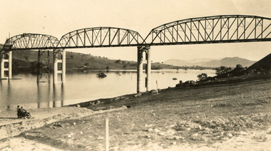
Taken between 1928 and 1930, depicted is the Bethanga Bridge under construction. The Bridge was completed in 1930 and was built to assist residents of the Bethanga district to travel to Albury. Other bridges would become submerged by the backed-up water of the Murray and Mitta Rivers so the Bethanga bridge was built two miles above the Mitta Weir. The Bethanga Bridge was built north of the future Hume Dam which would be completed in 1936. At 2430 feet long, Bethanga Bridge was the longest road bridge in Australia at the time of its completion. The Bridge is 20 feet wide and made up of nine 270 feet long spans. Materials used include ten tons of paint for the steel works; 1600 tons of steel; 900 tons of timber for the decking; and reinforced concrete for the piers. The tender for the construction was awarded to C. Ruwolt Pty. Ltd., engineers who were located on Victoria Street, West Richmond. The contract was awarded for £71,890. It was predicted between 250 and 300 men would find employment on the project. The news was well received by trade unions at the time as there had been a drop in available engineering work.This photograph is historically significant as it depicts the progress of the Bethanga Bridge construction, which was important infrastructure for the area. It is also a good example of methods used in the area to assist in travel over the river prior to the construction of the Hume Dam.Black and white rectangular photo printed on matte photographic paper.Reverse: 1997 3186 / 84-19-3 / This is the bridge. / It is not yet open to traffic / yet. will not be completed / until May next / It is a wonderful bridge the / pillars are 100 feet high. / KODAK PRINT Envelope Obverse: Peterson PHOTO / Hume Weir Envelope Reverse: BMM 84-20-1,2+3. bethanga bridge, lake hume, hume dam, hume weir, murray river, bridge, bethanga, albury -
 The Beechworth Burke Museum
Photograph, c.1927-1930
This image shows the Punt (a kind of small boat) that took residents of Bethanga across the Murray River before the Bethanga Bridge was built. Bethanga Bridge was built between 1927 and 1930, and was made a necessity by the building of the Hume Dam. The Hume Dam, formerly known as the Hume Weir, was in construction between 1919 and 1936, which swelled the Murray River into the floodplain to the East of the dam permanently, creating Lake Hume, and isolating the residents of Bethanga and nearby towns, for whom the trip all the way around the new lake to another river crossing was a massive undertaking. The person who wrote on the back of this card instead chose to cross the river on a boat until the Bethanga Bridge became available. Interestingly, partially submerged trees can be seen in the lake in the background of this photograph, illustrating that the dam had already begun to fill the floodplain even before the bridge was built. This photograph shows the methods the residents of Bethanga used while the Bethanga Bridge was being built. This record is associated with the Heritage Listed sites of the Hume Dam and the Bethanga Bridge, and shows the environment during the process of construction and the creation of Lake HumeSepia rectangular photograph printed on matte photographic paperReverse: 1997.3189 / 84 -19 -1 / This is the snap of the Punt. / Our only means of getting out / of Bethanga for the present / Until the bridge is completed / it is 2 miles above the junction / of the Mitta + Murray. It is / 1/2 a mile wide + runs across / the Murray into NSW / Kodak Print / bethanga, bethanga bridge, hume, hume dam, artificial lake, lake hume, hume weir, flood, floodplain, boat, punt, weir, pier, dock, transport, transportation -
 The Beechworth Burke Museum
Photograph - Photograph - Reproduction
The photograph is a reproduction of a postcard from the Rocky Mountain Mining Company. In 1875, the Rocky Mountain Extended Gold Sluicing Company Ltd was created, utilising the previous Rocky Mountain claim for the area near Lake Sambell. The company employed A.L Martin to survey an area for a tunnel underneath Beechworth and Johnson Stephens to dig it. The tunnel was built at a rate of 40 feet a month and eventually measured 800 metres. The tunnel was a true accomplishment both in the present and during the 19th century. It was considered to be a marvelous engineering feat. Beechworth is renowned for its hydraulic sluice method of mining. This involved soil being exposed to torrents of water from high-pressure hoses. From 1876 until its closure in 1921, the mine produced an astounding 47,926 ozs of gold. Companies like this were the source of income for many Chinese gold-diggers who sought to make their fortune on the goldfields of Beechworth. During the height of the rush, the town had around 7,000 Chinese inhabitants living on the outskirts of town as they were not permitted to live within Beechworth itself.This image of the Rocky Mountain mine is historically significant as the mining complex is now non-existent, with the only remains being the tunnel built in 1880 by the company, which was considered one of the greatest engineering feats of the time. The image also provides a first-hand look into the social and cultural networks at play during the 19th century with racial segregation of the Chinese at the 'Chinese Camp', as well as an insight into Beechworth's origins during the Gold Rush.Black and white rectangular reproduced photograph printed on paperbeechworth, rocky mountain mine, sluicing, gold rush, mining, gold -
 The Beechworth Burke Museum
Audio - Oral History, Jennifer Williams, Dr Roy Phillips, 8th October 2000 (exact date unclear)
Roy Phillips was born in 1907 in Yackandandah and moved with his family to Beechworth when he was five years old. His father was involved in dredging operations at Lake Sambell but his parents also had other family living in Beechworth, with whom they lived. Dr Phillips tells vivid stories about life in Beechworth in the first half of the Twentieth Century, from the daily lives of young children of the time to the town's relationship to the local Chinese community. He discusses features of the landscape such as 'The Rock' at which community concerts were held and 'The Echo' (an echo-sounding point over a nearby gully) which he states are no longer used in the same way. He also discusses changing community attitudes to various issues, for example, 'not being coddled' as a child but living in a town with very strict rules about people of different religions mingling. This oral history recording was part of a project conducted by Jennifer Williams in the year 2000 to capture the everyday life and struggles in Beechworth during the twentieth century. This project involved recording seventy oral histories on cassette tapes of local Beechworth residents which were then published in a book titled: Listen to what they say: voices of twentieth century Beechworth. These cassette tapes were digitised in July 2021 with funds made available by the Friends of the Burke.Dr Roy Phillips' account of his life in Beechworth in the early part of the 20th Century is historically and socially significant to the cultural heritage of the region. He describes town life from a child's point of view during a time of transition to life after the Gold Rush era, including social tensions existing between cultural groups such as the Chinese community and European-heritage townspeople and between people of different religious groups in Beechworth. This oral history account is socially and historically significant as it is a part of a broader collection of interviews conducted by Jennifer Williams which were published in the book 'Listen to what they say: voices of twentieth-century Beechworth.' While the township of Beechworth is known for its history as a gold rush town, these accounts provide a unique insight into the day-to-day life of the town's residents during the 20th century, many of which will have now been lost if they had not been preserved.This is a digital copy of a recording that was originally captured on a cassette tape. The cassette tape is black with a horizontal white strip and is currently stored in a clear flat plastic rectangular container. It holds up 40 minutes of recordings on each side.Dr Roy Phillips /beechworth, yackandandah, wangaratta, mining, dredging, 1910s, 1920s, 1930s, chinese community, typhoid, lake kerferd, reminiscences, memories, childhood, lake sambell, alcoholism, new year celebrations, transport, horses, foresters lodge, oddfellows lodge, funeral practices, child-rearing practices, star hotel, the rock, racism, chinese dragon, benevolent society, star lane coach building factory, outdoor concerts, gold, jimmy ingram, kelly gang, kelly family, churches, catholic, methodist, protestant, anglican, confuscionist, buddhism, women's christian temperance association, hotels, twentieth century, coronation of king george iv, echo point, the echo, tippany cat, marbles, children's games, cornish, cornwall, listen to what they say, oral history -
 The Beechworth Burke Museum
Audio - Oral History, Jennifer Williams, Isabel Wells, 24th February 2000
Isabel Wells was born in Beechworth in 1914. Her father, Mr. Newey, was a butcher; his shop was in Ford street and he took over from his grandfather. The family business, along with the local residents, was supplying the main government institutions in the region, like Mayday Hills Hospital and The Ovens and Murray Home, making a large percentage of his profit. Mr. Newey was also a captain of the fire brigade and Isabel mentioned that there were more fires happening in those days. The menace of a huge fire was impending in Beechworth for many years, due to the lack of adequate water supply and the absence of trained firefighters. The first fire brigade in the town was voluntary and was formed in 1858 under Superintendent Luke Reilly. A few other schemes deployed the following years, with all failing to sufficiently control the fires that occurred, until the creation of the first reliable fire brigade in the 1870s. The worst fire in the town's history happened on 23rd March 1867; it swept through many shops and the post office, leaving behind a damage cost estimated at £12,000. Isabel's mother was in a wheelchair, suffering from osteoarthritis; thus, Isabel had taken over the responsibility for looking after her mother and assisting her with daily living needs and personal care activities. She used to play golf and tennis and she was a member of the town tennis club. In terms of social life, Boxing Day was a big occasion for the town, with horse-races and games taking place. According to her narration, the use of cars was a turning point in the town's social activities, since people were able to visit nearby places and take day trips, such as having a picnic at Lake Kerferd or Buffalo. This oral history recording was part of a project conducted by Jennifer Williams in the year 2000 to capture the everyday life and struggles in Beechworth during the twentieth century. This project involved recording seventy oral histories on cassette tapes of local Beechworth residents which were then published in a book titled: Listen to what they say: voices of twentieth century Beechworth. These cassette tapes were digitised in July 2021 with funds made available by the Friends of the Burke. Isabel's account of her life in Beechworth and the local area during the 20th century is historically and socially significant as it offers valuable information about the business activity in the region and provides a deeper insight into the operation of butcher shops and meat supply during the first half of the previous century. Additionally, it offers invaluable information about the everyday life of people living in Beechworth, and highlights aspects of the overall social life and activities.This is a digital copy of a recording that was originally captured on a cassette tape. The cassette tape is black with a horizontal white strip and is currently stored in a clear flat plastic rectangular container. It holds up 40 minutes of recordings on each side.Mrs Isabel Wells/ isabel wells, beechworth, mr. newey, ford street, butcher, mayday hills hospital, the ovens and murray home, fire brigade, 23rd march 1867, fire, osteoarthritis, boxing day, horseraces, lake kerferd, buffalo, picnic, cars, firefighters, luke reilly, wheelchair -
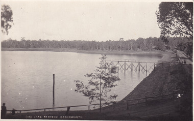 The Beechworth Burke Museum
Postcard, 1910 - 1912
This photograph is taken of Lake Kerferd in around 1910. The photograph shows the road circling around the large lake and the jetty on the lake. On the other side, there is a written message from Fred Pulling to Win Pulling. Fred seems to have gone away and was not sure when he would return. He was also glad to hear about a gentlemen called Perc, who he stated to be a 'decent enough chap'.This postcard is significant because Lake Kerferd itself is significant within Beechworth's history. This lake was constructed in 1862 and was named after the former Beechworth Mayor, Hon. G B Kerferd. This lake was originally constructed to supply the town with water. Fred's correspondence with Win demonstrates a glimpse into what life was like during this time. Black and white rectangular postcard printed on cardObverse: (113) Lake Kerferd Beechworth / Reverse: Beechworth / 29.11.19 / [ Stamped: POST CARD / KODAK AUSTRALIA / Dear Win / Gald to hear that you / have made up your mind about / Perc / He seems a decent enough chap / too / Anyway, Thanks for the letter / Dont exactly know when we are / returning / will write later. Regards / to Nell of course, and H. (indecipherable) / Lots of love / Fred / lake kerferd, jetty, chap, postcard, letter, trees, lake, horse drawn carriage, horse drawn cart, kodak, australia, gum trees, gravel road, beechworth, kerferd