Showing 10999 items matching " land"
-
 Whitehorse Historical Society Inc.
Photograph, Land clearing, Mitcham, C1960's
2 coloured photographs showing a bull dozer clearing land in Mitcham.mitcham, land clearing -
 Greensborough Historical Society
Document, Victoria. Department of Environment Land Water and Planning, Proposed planning changes for Austin Hospital, 28/10/2016
Information on proposed changes to heritage overlays on the Austin Hospital site on Studley Road Heidelberg4p. coloured information sheet, with one page covering letter from the Government Land Standing Advisory Committeeaustin hospital -
 Whitehorse Historical Society Inc.
Article, Many Questions on Land, 1/09/2014 12:00:00 AM
The Victorian State Governme.nt will protect 2 parcels of land totalling 15.4 ha. of the Healesville Freeway Reservation as Crown Land.The Victorian State Government will protect 2 parcels of land totalling 15.4 ha. of the Healesville Freeway Reservation as Crown Land and the planned walking and cycling path, running it's entire length, will go ahead.The Victorian State Governme.nt will protect 2 parcels of land totalling 15.4 ha. of the Healesville Freeway Reservation as Crown Land.healesville freeway reservation, cycling path, walkinig path -
Ringwood and District Historical Society
Book, Borough of Ringwood Land Purchase Fund Cash Book and Ledger
Bound book "Borough of Ringwood Land Purchase Fund Cash Book and Ledger" -
 Whitehorse Historical Society Inc.
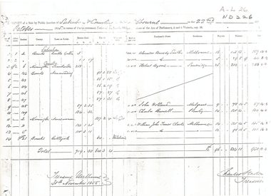
Legal record - Report, Land Sale, 01/10/1855
Report of land sale by public auction, October 1855 suburb and country MelbourneReport of land sale by public auction, October 1855 suburb and country MelbourneReport of land sale by public auction, October 1855 suburb and country Melbournesmith, alexander kennedy, byrne, robert, holland, john, burrell, charles, clarke, william john turner, land sales -
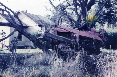
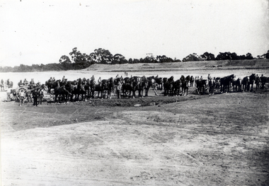 Whitehorse Historical Society Inc.
Photograph - Black & white photograph, Clearing Land for Mitcham Reservoir
Black and white photo of Teams of Horses clearing Land for M.M.B.W. Reservoir at Mitcham.meagher, ray, melbourne and metropolitan board of works, mitcham reservoir -
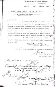 Ringwood and District Historical Society
Document, Ringwood State School - Exchange of Land along Greenwood Avenue, 1920
Photocopy of 2 documents.Document 1, Memorandum from the Government Valuer, Department of Public Works re Exchange of Land at Ringwood School, dated 9th November, 1920. Document 2, Plan of Exchange of Land in Greenwood Avenue, 1920. -
 St Kilda Historical Society
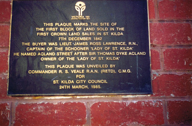
Photograph, Plaque marking the site of the first block of land sold in the first Crown Land Sales in St Kilda 7 Dec 1842, c. 1980s?
colour photograph unmounted (2 identical photographs)This plaque marks the site of the first block of land sold in the first Crown Land Sales in St Kilda 7 Dec 1842. The buyer was Lieut. James Ross Lawrence, R N, Captain of the Schooner 'Lady of St Kilda'. He named Acland st after Sir Thomas Dyke Acland, owner of "The Lady of St Kilda". This plaque was unveiled by Commander RS Veale RAN (retd) CMG for St Kilda City Council. 24 March 1985. -
University of Melbourne, Burnley Campus Archives
Document, Institute of Land & Food Resources, 2000
Folder containing Campus Information, National Undergraduate Curriculum, Land & Food, 5th ed. university of melbourne, institute of land and food resources -
University of Melbourne, Burnley Campus Archives
Document, Reclamation of land at Burnley, 1961-1967
Correspondence between T.H. Kneen, City of Richmond and Dept. of Agriculture re reclamation of landt.h. kneen, burnley, land reclamation -
Whitehorse Historical Society Inc.
Book, Land Settlement, 1987
Land settlement and economic development in Nunawading. University of Melbourne History Honours Thesis. 1987Land settlement and economic development in Nunawading. University of Melbourne History Honours Thesis. 1987Land settlement and economic development in Nunawading. University of Melbourne History Honours Thesis. 1987city of nunawading, land settlement, commercial development -
 Whitehorse Historical Society Inc.
Document, Land Sale Forest Hill
20 acres of land at Forest Hill20 acres of land at Forest Hill Nunawading on Canterbury Road next to Wesleyan Chapel.20 acres of land at Forest Hillwesleyan chapel, willson, henry, hunt's lane, forest hill, mount pleasant methodist church -
Whitehorse Historical Society Inc.
Article, Deal close in Vermont land battle, 1990
Article about the negotiation between the residents and land developers over Wunderlich site developmentArticle about the negotiation between the residents and land developers over Wunderlich site development.Article about the negotiation between the residents and land developers over Wunderlich site developmentrooks road vermont, land subdivision, mitcham road vermont, wunderlich limited -
 Whitehorse Historical Society Inc.
Document, Summary of land acquisition and disposal associated with Antonio Park, n.d
Summary of land acquisition and disposal associated with Antonio Park,Summary of land acquisition and disposal associated with Antonio Park, including plan of general area.Summary of land acquisition and disposal associated with Antonio Park, antonio park, mitcham, parks and reserves -
 Ringwood and District Historical Society
Article - Newspaper Clipping, Land Sale Advertisements, Golden Hill Estate, Ringwood - 1965, 1966, and Plan of Survey of Lot 8, Mullum Mullum Road Ringwood, 1970
Newspaper clippings from Melbourne Sun newspaper (11th December 1965 and 15th January 1966) advertising sale of land - Golden Hill Estate, Ringwood, with summary of features and aerial photograph including artistic representation of street layout. Subdivision includes Mullum Mullum Road, Sonia Street, Jill Court, Linda Drive, Eve Court, Alma Court, and Jacynthe Court. Attachments include reference to Lot 46 as site of original Peter Vergers' orchard residence and subsequent 1970 surveyor's Plan of Survey of Lot 8 Mullum Mullum Road Ringwood, LP 67513, Cert of Title 8581/429.Agent - Aaron, King & Co., Suite 2, 33 Queens Road, Melbourne. (Phone) 26-2443, A.H. 850-2195. Plan of Survey signed on 25.7.1970 by Roger M. Gamble, Land Surveyor, 28 Summit Crescent, Ringwood 3134. -
 National Wool Museum
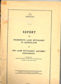
Book, Report on progressive land settlement in Queensland by the land settlement advisory commission
"Report on progressive land settlement in Queensland by the land settlement advisory commission " W L Payne, Commissioner, 1959. Deals at length with the leasing of Queensland government land and its suitability for raising sheep.pastoral industry - settlement sheep stations - establisment, land settlement advisory commission, pastoral industry - settlement, sheep stations - establisment -
![Map, Ballarat and Gordons Lane Plan of Land required [for railway line work]](/media/collectors/5e461d8021ea67224c82f2a1/items/676ff3a62c3783fe00b96a8d/item-media/676ff4a42c3783fe00b96cb6/item-fit-380x285.jpg) Bacchus Marsh & District Historical Society
Bacchus Marsh & District Historical SocietyMap, Ballarat and Gordons Lane Plan of Land required [for railway line work]
The railway line from Melbourne to Bacchus Marsh was completed in February 1887. After this date work continued to extend the line to Ballan. This map indicates a portion of land only a few hundred metres west of the Bacchus Marsh railway station which would have been among the first stages of the line to Ballan to have been constructed. This suggests the date of this map to be in the late 1880s.Single page map showing land required for railway line work near Griffith Street, Bacchus Marsh. Scale 10 chains to 1 inch. Hand-written on the map are the exact distances between Bacchus Marsh and Gordons (Gordon) and between Bacchus Marsh and Melbourne as measured from the corner of Maddingley Road and Station Street. Distances recorded are in miles, chains and links. The land required for the railway works is marked in red ink and runs through an area known as Kennedy's Gully. Part of a set of maps which are pasted into a bound volume containing 76 maps or plans in total. High resolution digital image stored on BMDHS computer network. bacchus marsh victoria history, maddingley victoria history, railway lines -
Clunes Museum
Document - REPORT, LAND CONSERVATION COUNCIL OF VICTORIA, FINAL RECOMMENDATIONS - NORTH CENTRAL AREA, FEBRUARY 1981
THE LAND CONSERVATION COUNCIL WAS ESTABLISHED BY THE LAND CONSERVATION ACT 1970. AS ONE OF ITS THREE FUNCTIONS, IT MAKES RECOMMENDATIONS TO THE MINISTER FOR CONSERVATION WITH RESPECT TO THE USE OF PUBLIC LAND, IN ORDER TO PROVIDE FOR THE BALANCED USE OF LAND IN VICTORIA...BOUND BOOKLET - ORANGE SOFT COVER WITH NAVY BLUE BINDING LAND CONSERVATION COUNCIL, VICTORIA MELBOURNE - FEBRUARY 1981 - INCLUDING MAPSnon-fictionTHE LAND CONSERVATION COUNCIL WAS ESTABLISHED BY THE LAND CONSERVATION ACT 1970. AS ONE OF ITS THREE FUNCTIONS, IT MAKES RECOMMENDATIONS TO THE MINISTER FOR CONSERVATION WITH RESPECT TO THE USE OF PUBLIC LAND, IN ORDER TO PROVIDE FOR THE BALANCED USE OF LAND IN VICTORIA...local history, document, recommendations, land conservation -
University of Melbourne, Burnley Campus Archives
Booklet - Course Information, Advanced Certificate in Horticulture, 1999
courses, t.a.f.e. -
 Churchill Island Heritage Precinct
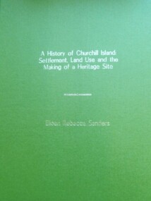
Book - Thesis, Dr E. Rebecca Saunders, A History of Churchill Island: Settlement, Land Use and the Making of a Heritage Site, 2015
An exploration of the intersections between the practices of community engagement, academia and history, the thesis responds to the challenges thrown up by the History Wars and the Churchill Island Project by making a history of settlement that is both academically critical and publicly accepted.A4 format bound text, with green front and back covers and gold writing on front page.non-fictionAn exploration of the intersections between the practices of community engagement, academia and history, the thesis responds to the challenges thrown up by the History Wars and the Churchill Island Project by making a history of settlement that is both academically critical and publicly accepted.saunders, churchill island, settlement, land use, heritage site, thesis 2015 -
 Warrnambool and District Historical Society Inc.
Document, Lease of Land by Victorian Railways to Warrnambool Woollen Mill Co Ltd, 1952
The Warrnambool Woollen Mill was established in 1910 in South Warrnambool by a local company, with the building erected on a site that formerly housed another woollen mill destroyed by fire in 1882. The Warrnambool Woollen Company operated successfully for many years with over 700 employees in the 1940s and a good national reputation for quality goods. It made blankets and other woollen goods and was the first company in Australia to manufacture electric blankets. In the 1960s the mill was sold to the Dunlop Company and for the next thirty years it was bought and sold several times, finally closing in 2000 after 90 years of operation. The woollen Mill was built on a site which was in easy access to the railway line which operated along the original tramway line from the town to the jetty. It is possible that this land would have been used for parking during the period of 1950's to 1970's which was a successful period of manufacturing and trade for the Woollen Mill. A link between an important infrastructure and one of Warrnambool's most important industries.Four page folded document cream in colour . Printed form with diagram of the land in question coloured in pink . Seals of both Victorian railways and Warrnambool Woollen mill are stamped beside signatories on page 3. Dated 30th April 1952. Signed R Naylor for the Warrnambool Woollen Mill and two unreadable signatures for Victorian Railways.warrnambool, warrnambool woollen mill, warrnambool railways, lease victorian railways and warrnambool woollen mill -
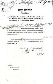 Phillip Island and District Historical Society Inc.
Document, Grant to W.J.McHaffie for lease of Crown land
J D McHaffie, Phillip Island's first leaseholder, relate how McHaffie set up his headquarters (and later built his house) alongside what is now known as McHaffies lagoon. The McHaffie brothers – John David and William – occupied Phillip Island under a license from the Admiralty in 1842 and farmed it as a sheep run.Historical3 A4 photocopies showing application for lease in 1850, size and description of the land and instructions for the application.w.j.mchaffie, land grant, farming, saltwater creek, crown land -
4th/19th Prince of Wales's Light Horse Regiment Unit History Room
Booklet, Manual of Land Warfare Part 1 Vol 1 Pam No 5 Fire Support 1977, 1977
A soft covered booklet describing the principles and processes of the application of fire support in tactical land operations.DSN 7610-66-093-7741fire support, doctrine, fire support, doctrine -
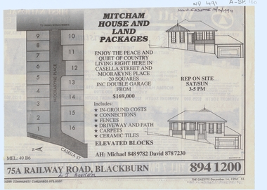 Whitehorse Historical Society Inc.
Article, Mitcham house and land packages, 14/12/1994 12:00:00 AM
house and land package in Moorakyne PlaceAdvertisement in Nunawading Gazette for house and land package in Moorakyne Place Mitcham, 14/12/1994.house and land package in Moorakyne Placeland subdivision, moorakyne place, mitcham, casella street, l. j. hooker -
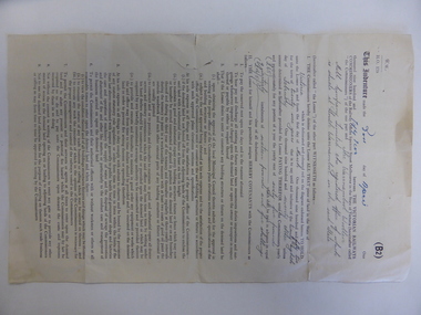
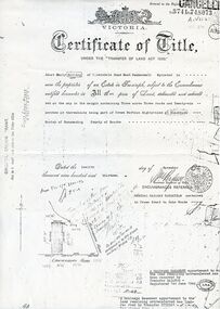
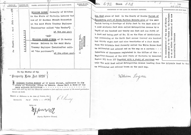 Whitehorse Historical Society Inc.
Document - Land Title, Record of Land site, 07/07/1930
Copy of record of sale by William Logan to William James O'Shea of land on Metropolitan Avenue, Nunawadingmetropolitan avenue, nunawading, logan, william, o'shea, william james, land sales -
 Whitehorse Historical Society Inc.
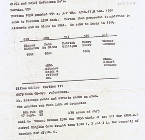
Document, Land subdivision, n.d
notes of records of land dealings in parts of Crown Portions 120 and 111, 1858 - 1886.Photocopy of notes of records of land dealings in parts of Crown Portions 120 and 111, 1858 - 1886. notes of records of land dealings in parts of Crown Portions 120 and 111, 1858 - 1886.land subdivision, richards, thomas, mcglone, john, gilligan, patrick, emery, henry, parsons, charles robert, lobb, graham, gale, alfred chaplin, mitcham brick and pottery co. ltd -
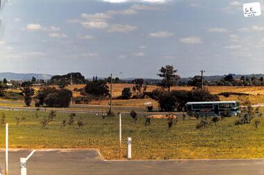 Whitehorse Historical Society Inc.
Photograph, Tally Ho Land
Coloured photo of Tally Ho Land, Corner Springvale Road and Burwood Highway before development.tally ho -
 Whitehorse Historical Society Inc.
Document, Land purchase Certificate of Title, 12/11/1913 12:00:00 AM
Plan of subdivision of land in the Shire of Nunawading which includes 'Wandinong'.Plan of subdivision of land in the Shire of Nunawading which includes 'Wandinong'. Copy of Certificate of Title of Crown Grant to Janet Emily Hooke, nee Billing, dated 12/11/1913, also purchase of land by J. Woods dated 31/3/1856.Plan of subdivision of land in the Shire of Nunawading which includes 'Wandinong'. haines, william, woods, john, hooke, janet emily, billing, wandinong sanctuary, canterbury road, blackburn, blackburn road -
Ringwood and District Historical Society
Document - Land Title, John Quinlan et al, Land title (Ringwood) and correspondence between George Pratt of Nunawading and the Commissioner of Crown Lands 1869-1877, 1869
Land title and correspondence between George Pratt and the Commissioner of Crown Lands and Survey dated 19th(?) August 1869. Numbered 16678 (1M) plus 20 pages marked 42M-61M +Additional Keywords: Commissioner of Land and Survey / Longmare, Mr. / Quinlan, John -
University of Melbourne, Burnley Campus Archives
Card - Bookmark, Study Horticulture, 2005
open days, burnley campus, mcmillan campus