Showing 811 items
matching maps and sections
-
 Glenelg Shire Council Cultural Collection
Medal - Medal - Syd Cuffe, Town Crier, c. 1995
Medal, copper, shaped like globe with banner, with star at each end, bell in centre, surrounding map of Australia. Bottom section of bell, including clapper, form part of shape of medal. Attached to green and gold ribbon.Front: '6th World Town Crier Championships Ballarat '95 ' -
 Bendigo Historical Society Inc.
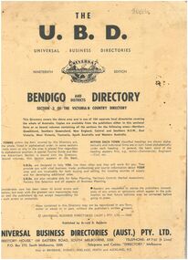
Booklet - The Universal Business Directory (UBD)
The Nineteenth Edition of the Bendigo and Districts Universal Business Directory, which is Section 3 of the Victorian Country Directory for 1969. The directory includes classified sections for Bendigo and surrounding towns, including Carisbrook, Castlemaine, Eppalock, Harcourt, Malmsbury, Maryborough, Newbridge, Raywood, Tooborac and Yapeen. It also includes an Eaglehawk Traders section, emergency phone numbers and maps of Bendigo, Castlemaine, Kangaroo Flat and Maryborough. The booklet is made of soft flimsy paper with black print and contains 51 pages.There is a grey lead scribble on back page between the '6' and '7'.bendigo businesses, bendigo maps, 1960s, bendigo business directory -
 Bendigo Historical Society Inc.
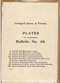
Book - MCCOLL, RANKIN AND STANISTREET COLLECTION: PLATES TO ACCOMPANY BULLETIN NO.49 MALDON GEOLOGICAL SURVEY OF VICTORIA
Book; Brown paper containers with plates (& maps) to accompany bulletin No49 of geological survey of Victoria. V Oswalds G.M. Plan of lease. VI. Oswalds G. M. Plan of workings. VII. Oswalds G. M. Transverse Sect. VIII. Oswalds G. M. Longit. Section. IX. Oswalds G. M. Plan & Sect. 500ft. Level. X. Northey's Reef plan & sections. XI. Carlisle and Whittaker's Mine Plan & Sections.XII. Goldsborough G. M. Co. Gordon's Reef, Plan & Section. XIII. Mount Tarrengower Tunnel Plan & Section.MCCOLL RANKIN & STANISTREETorganisation, industry, surveys, mccoll rankin & stanistreet -
 Bendigo Military Museum
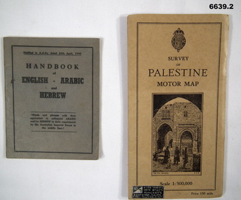
Booklet - HANDBOOK & ROAD MAP, April 1940
Sold by Ringarts Bookshop, Haifa1. This is a small pocket book, grey cover, black ink printing. It has words and phrases of colloquial Arabic and/or Hebrew. 32 pages. It is for Australian Imperial Forces in the Middle East. 2. Palestine Road Map. It has cardboard cover and opens out to a road map, scale 1:500,000. It has a drawing of the old section of Jerusalem on front cover.passchendaele barracks trust, 1. nr9430t, 2.9431t, ww2 -
University of Melbourne, Burnley Campus Archives
Plan, Burnley College Site, c. 1970 - 2001
Miscellaneous plans of the Burnley site with enlargements of sections. Roughly sorted. Different periods. Includes a map of Kew, and part of plan of Charman Ave., Emerald. Annotated plan of area of glass houses and chicken test pens ((1970 - 80?)burnley college, gardens, college buildings, kew, emerald -
 Kew Historical Society Inc
Map, MMBW, MMBW Plan No.40 Collingwood & Kew, 1900-1910
The Melbourne and Metropolitan Board of Works (MMBW) was established by an act of the Victorian Parliament in 1890 to prepare for and to implement a sewerage and water reticulation system across what was then inner Melbourne, its surrounding and middle distance suburbs, including Kew. The MMBW was disbanded in 1991.The map collection of the Kew Historical Society has at its core the historic maps assembled and originally stored in the City Engineer's Department of the City of Kew. These include maps in a number of scales. The vast majority of maps were produced by the MMBW in the first two decades of the twentieth century, and are solid working maps, backed by linen for durability. These maps are historically significant to Kew, the City of Boroondara and to the history of the development of state utilities in Victoria. A number of the Kew maps have additional details added by former municipal officers, including the levels reached by various floods. As these were working documents, information was added to them long after the period of their initial production and distribution.Early map of part of the Borough of Kew, created in the first decade of the twentieth century, at a scale 160 ft to 1 inch. The map covers what was then the south western section of Kew, bordered on its north by Studley Park Road, in the west by Walmer Street and the River Yarra, by High Street South and Princess Street in the East and Barkers Road in the south. The map shows the extent of urban development by that time, prominent institutions and the outlines of built structures in the municipality. Contour lines and historic flood levels were added in ink to the map at a later stage.MELBOURNE AND METROPOLITAN BOARD OF WORKS / PLAN NO. 40 / COLLINGWOOD & KEWmelbourne & metropolitan board of works, mmbw maps, mmbw plans, borough of kew, cartography -
 Melbourne Tram Museum
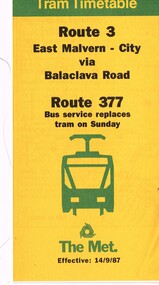
Ephemera - Timetable/s, The Met, "The Met Tram Timetable", Mar. 1987
The Met Tram timetables, folded sheets, generally 8 sections, providing timetables for specific routes, day of week giving information on tram times at specific time points, route map, sections and fares and phone contact numbers. Route 3 - East Malvern - City via Balaclava Road and Route 377 - bus service - dated 14/9/1987.trams, tramways, the met, timetables, melbourne, fares, route 3, route 377, bus replacement -
 Bendigo Historical Society Inc.
Document - MARKS COLLECTION: SECTION OF MAIN CHANNEL
Plan drawn on waxed type paper, fragile. Written in centre of map 'Section on Centre of Main Channel, Scale horizontal 2 chs, vertical 10ft., to an inch'. Plan shows Melbourne Road on top section. Written in red ink '5,000,000 galls in 24 hours = 3472.2 gals per minute'. Plan located in documents from George Lansell auction.bendigo, mining, water channel section -
 Melbourne Tram Museum
Ephemera - Tram Route Guides, Metlink, Set of 12 Metlink route maps, c2008?
... Set of 12 Metlink route maps ...Set of 12 Metlink route maps, DL, providing a line map with the major stops, roads, approx. times for each section, ticketing zones and on the rear, service frequency and information about Metcards. All the same front styles, but three different styles on rear. Possibly produced before the route maps at Reg item 2443, not dated. Route 3, 5, 6, 8, 16, 19, 57, 59, 64, 67, 72, 78, 79,trams, tramways, metlink, tram services, timetables, route 3, route 5, route 6, route 8, route 16, route 19, route 57, route 59, route 64, route 67, route 72, route 78, route 79 -
 Melbourne Tram Museum
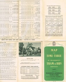
Map, Melbourne & Metropolitan Tramways Board (MMTB), "Map and timetable of Melbourne Tram and Bus Services" - May 1956", May. 1956
Fold out map (10 sections), coloured of Melbourne's Tram and Bus routes, route numbers, rail lines, municipalities boundaries and location of major places of interest. Titled - "Map and timetable of Melbourne Tram and Bus Services" - May 1956". At base of map - timetable of all night trams and bus services. On rear index to routes, 1st and last services, time of Sunday am services, LaTrobe St. services and photo of Wattle Park. Dated May 1956. Note the inset map shows Bourke St as a bus. Three copies held. 413.1 - as for above but with a pasted over section titled "Time table of all - night bus services" on the base of the map replacing the all night tram and bus services. Dated 3/7/1957. Copy from donation of Gary Butler added 3/12/15. See Reg Item 2300 for the March 1952 version.trams, tramways, melbourne, map, tram & bus services, all night services, mmtb -
 Ballarat Tramway Museum
Poster, State Electricity Commission of Victoria (SECV), "Schedule of Fares and Charges", 1937
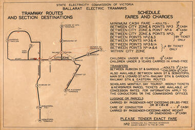
... sections ...Shows Ballarat Tramway (SEC) Fares, Charges, and Section Map. Also gives charges for the various sections, transfers, luggage of parcels, age of children. All fares in pence. In particular note the 1d fares for Sebastopol Post Office and the City Zone. See item 8025 for a the printed explanation of the new fare system introduced by the SEC in Ballarat from Sunday 3/10/1937,Demonstrates the work the SEC undertook to provide information on the new ticket system of 1937 and yields information about the system.Poster - printed on manila card in black ink.Numerous pencil and red colour pencil markings.tramways, sec, fares, sections, tickets -
 Melbourne Tram Museum
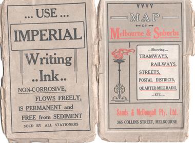
Map, Sands and McDougall Pty Ltd, "Map of Melbourne and Suburbs showing Tramways, Railways, Streets, postal districts, Quarter-Mile Radii etc", c1930
... Maps ...Produced by Sands and McDougall Pty Ltd of Collins St Melbourne. Map - folded sheet of paper 5 sections wide x 6 sections or folds deep contained within a dark grey paper cover titled "Map of Melbourne and Suburbs showing Tramways, Railways, Streets, postal districts, Quarter-Mile Radii etc", showing both cable and electric tramways. verted, but not Market St to Port Melbourne or South Melbourne. Shows the Collins St line being constructed. Collins St routes were opened late 1929, map produced during the early 1930's prior to the closure of Market St - Port Melbourne. Has a detailed list of the postal districts.trams, tramways, maps, melbourne, cable trams, tramways, railways -
 Warrnambool and District Historical Society Inc.
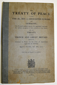
Book, The Treaty of Peace, 1919
A record of the Treaty of VersaillesThis is a book of 451 pages. It has a grey cover with black printing on the front and a grey baize cloth binding. The binding has a tear in the spine section. The pages contain printed text in French and English and five maps inserted into a folder at the back.non-fictionA record of the Treaty of Versaillesworld war one, treaty of versailles -
 Ringwood and District Historical Society
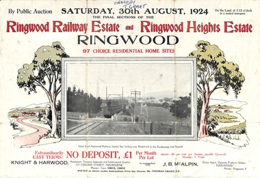
Flyer, Auction Sale Advertisement - Ringwood Railway Estate and Ringwood Heights Estate, Ringwood, Victoria - August, 1924
Refer also to Reg. No. 5183 for Ringwood Railway Estate (September 1923) and Reg. No. 5184 for Ringwood Heights Estate previous release (March 1924)Folded double-sided brochure advertising public auction of Final Sections of Ringwood Railway Estate and Ringwood Heights Estate on Saturday, 30 August, 1924, with town photographs, location map, terms of sale, and summary of local features and services.Subdivision includes Whitehorse Road, Sherbrooke Avenue, Burwood Avenue, Bon View Avenue, Grant Crescent, Hillcrest Avenue, Heatherbrae Avenue, Margaret Street, and Mary Street. (Agents) Knight & Harwood, 315 Collins Street, Melbourne, Phones Central 10615, 10616, in conjunction with J.B. McAlpin, Opposite Railway Station, Ringwood, Phone Ringwood 7. Footnote - "Will sell as above under instructions from the Owner, Mr. Thomas Grant, J.P.". -
 Bendigo Historical Society Inc.
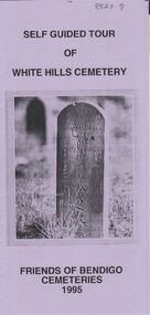
Document - BENDIGO CEMETERIES COLLECTION: SELF GUIDED TOUR WHITE HILLS CEMETERY DOCUMENT
BHS CollectionLilac coloured trifold document: Self guided tour of White Hills Cemetery, Friends of Bendigo Cemeteries 1995. Map with numbered grave sites e.g. Large Jewish section with over 80 known burials. Graves of Afghan traders,Friends of Bendigo Cemeteries, 1995bendigo, cemetery, white hills cemetery tour -
 Melbourne Tram Museum
Map, Ministry of Transport, "Metropolitan Transport Services Map - Melbourne Tram, Train and Bus Services", 10/1971
Fold out map (27 sections 9 across x 3 deep), coloured of Melbourne's Tram and Bus routes, route numbers, rail lines, detailed for the central part of Melbourne. On rear description of routes, private bus routes and map of Melbourne metro lines. Has contact details for bookings and lost property etc. Priced at 10c. Launched in a newspaper advert 26/10/1971. Has map scale in miles. 2nd copy added 16/7/2014On front cover in ink "#1" in top right hand corner and "4 G 33" along bottom edge.trams, tramways, melbourne, map, tram & bus services, railways, mmtb, minister for transport -
Bendigo Historical Society Inc.
Map - MAP: VIRGINIA MINE GARDEN GULLY LINE OF REEF
Map of Virginia Mine on the Garden Gully line of reef, Eaglehawk, transverse section. Shaft, levels and Garden Gully anticlinal axial line drawn. Key shows types of formations - quartz, spurs, sandstone, slate, cleavage, lava. This map forms part of the Geological Survey of Victoria, Structure of Bendigo Goldfield report, No. 47, 1923. H.Herman, late Director of Geological Survey.Geological Survey Victoria, Geological Survey Office, Bendigo.bendigo, gold mining, virgina mine eaglehawk, eaglehawk, bendigo, gold mining, virginia mine, garden gully line of reef. -
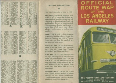 Ballarat Tramway Museum
Map, H.P. Noordwal, "Official Route Map of the Los Angeles Railway", Jun. 1938
A (12 section) fold out map of street car (tram) and bus services for Los Angeles, dated June 1, 1938, showing all LAR (Los Angeles Railway) streetcar and coach (tram and bus) services, Pacific Electric lines within area, detailed "downtown" map, route descriptions and points of interest. Record images added 20/8/2013.Three terminus have been marked with pencil "X". On rear car, next to object number is a symbol looking like a "H & S" merged together.trams, tramways, los angeles, street cars, map -
 Ballarat Tramway Museum
Map, Compiled by MMTB, "Map and timetable of Melbourne Tram and Bus Services" - May 1956, May. 1956
Fold out map (10 sections), coloured of Melbourne's Tram and Bus routes, route numbers, rail lines, municipalities boundaries and location of major places of interest. At base of map - timetable of all night trams and bus services. On rear index to routes, 1st and last services, time of Sunday am services, Latrobe St. services and photo of Wattle Park.trams, tramways, melbourne, map, tram & bus services, all night services, mmtb -
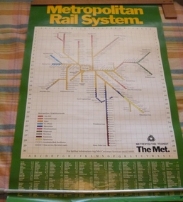 Melbourne Tram Museum
Poster, The Met, "Metropolitan Rail System", mid 1980's
Poster, full colour printed on gloss paper titled "Metropolitan Rail System", giving a diagrammatic Map of the rail system. Shows the sections of line in each Neighbourhood and they colour code At the base of the map has The Met logo and name, a customer service number which has been glued over the printed number. At the base of the poster is a location guide for each railway station.trams, tramways, the met, map, tickets, neighbourhood tickets, railways -
 Bendigo Historical Society Inc.
Map - HUSTLER'S CONSOLS MINE - TRANSVERSE SECTION OF THE HUSTLER'S CONSOLS MINE
Transverse Section of the Hustler's Consols Mine Bulletin No 33, Plate No XXXIII. Map shows poppet legs at the surface and Sill of Shaft 779.42 feet above Sea Level. Shows the different levels and their depths and the different stone and geographical features encountered. Has larger drawing of Section A - B. Geographical Survey of Victoria. Signed by H A Whitelaw, Underground Survey Office Bendigo, September 1913. mining, parish map, hustler's consols mine, transverse section of the hustler's consols mine, geological survey of victoria, underground survey office bendigo, h a whitelaw -
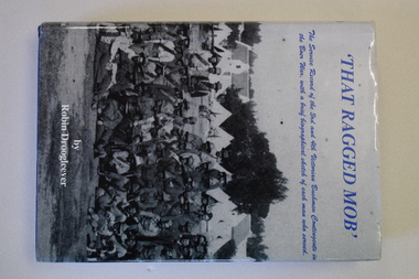 Warrnambool and District Historical Society Inc.
Book, That Ragged Mob, 2009
This Boer War book was written by Robin Droogleever. It is a comprehensive history of the 3rd and 4th Victorian Bushmen Contingents and gives biographical details on everyone who served in these units. Many of the men in these units came from Warrnambool and the surrounding districts and many had been members of the Mounted Rifles or the Western Artillery units before enlisting to serve in the Boer War. One of these was Major Joseph Dallimore from Lake Gillear and his diaries are used extensively in this book as a primary historical source of the events of the war.This is an important reference book detailing the history of the 3rd and 4th Victorian Bushmen Contingents in the Boer War. This book contains many references to the servicemen in the Boer War who were in those units and who came from Warrnambool and district This is a hard covered book of 706 pages. The cover is blue with gold printing on the spine. The dust cover has an off white background with a photograph of some Boer War soldiers on the front and spine and colour photographs of medals, a shoulder badge and a war memorial on the back cover.The text is in two sections with eight parts in the first section and nine parts in the second section. The book contains many black and white photographs, maps and sketches and brief biographical notes on the soldiers who served in the military units described in the book. To Elizabeth O Callaghan, my best wishes, Rob Droogleever 17/10/09boer war, warrnambool -
Bendigo Historical Society Inc.
Book - REPORT ON THE NORTH CENTRAL STUDY AREA OF VICTORIA
252 page Report on the North Central Study Area by the Land Conservation Council of Victoria - July 1978 Illustrated with B&W photos Back section contains several removeable maps. Printed by F D Atkinson, Government Printer, MelbourneLand Conservation Council, Victoria -
 Bendigo Historical Society Inc.
Map - FORTUNA HUSTLER'S MINE - PLAN OF THE FORTUNA HUSTLER'S MINE
Plan of the Fortuna Hustler's Mine, Bulletin No 33, Plate No II. Geological Survey of Victoria. Signed by H A Whitelaw, Underground Survey Office Bendigo, September 1913. Map shows levels and depths. There are smaller drawings of some sections of some levels. mining, parish map, fortuna hustler's mine, plan of the fortuna hustler's mine, geological survey of victoria, h a whitelaw, underground survey office bendigo -
 Bendigo Military Museum
Photograph - Army Survey Regiment - Regimental Training Field Phase, c1988
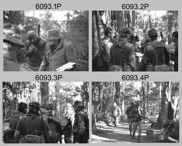
This is a set of 31 photographs of Army Survey Regiment personnel undertaking regimental training in the Wellsford Forest, Bendigo, c1988. The aim of the training was to provide personnel a practical knowledge of infantry and minor tactics at the section level, navigation and map reading, RATEL and Survival in the Field. This is a set of 31 photographs of the Army Survey Regiment undertaking regimental training in the Wellsford Forest, Bendigo. c1988. The photographs were printed on photographic paper and negatives are on 35mm film. They are part of the Army Survey Regiment’s Collection. The photographs were scanned at 300 dpi and negatives at 96 dpi .1) - Photo, black & white, c1988, unidentified personnel. .2) - Photo, black & white, c1988, CPL Terry ‘TJ’ Wicker 3rd from right. .3) - Photo, black & white, c1988, unidentified personnel. .4) - Photo, black & white, c1988, unidentified personnel. .5) - Photo, black & white, c1988, L to R: CPL Steve Coulson, unidentified. .6) - Photo, black & white, c1988, L to R: SPR Kerron South, unidentified – radio, unidentified personnel, SPR Wally Twidale. .7) - Photo, black & white, c1988, unidentified – radio, .8) - Photo, black & white, c1988, L to R: CPL John Bettridge, SPR Wally Twidale, SPR Shane ‘Soupy’ Campbell. .9) - Photo, black & white, c1988, SPR Kerron South .10) - Photo, black & white, c1988, L to R: unidentified, CPL Terry ‘TJ’ Wicker, unidentified. .11) - Photo, black & white, c1988, unidentified personnel. .12) - Photo, black & white, c1988. .13) - Photo, black & white, c1988. .14) - Photo, black & white, c1988, L to R: unidentified personnel, SPR Kerron South .15) - Photo, black & white, c1988, unidentified, CPL Terry ‘TJ’ Wicker, unidentified. .16) - Photo, black & white, c1988, L to R: unidentified personnel, SPR Jim Ash. .17) - Photo, black & white, c1988, MAJ Rene van den Tol .18) - Photo, black & white, c1988, L to R: WO2 Pat Lumsden, SPR Sue (Foote) Bourne. .20) - Photo, black & white, c1988, vehicles. .21) - Photo, black & white, c1988, tentage. .21) - Photo, black & white, c1988, L to R: MAJ Roger Rix, CAPT Dave Sankey, MAJ Bob Roche, unidentified. .23) - Photo, black & white, c1988, L to R: WO2 Alan Bunn, unidentified. .24) - Photo, black & white, c1988, unidentified personnel. .25) - Photo, black & white, c1988, unidentified personnel. .26) - Photo, black & white, c1988, unidentified personnel. .27) - Photo, black & white, c1988, L to R: unidentified personnel, WO2 Rob Bogumil. .28) - Photo, black & white, c1988, unidentified personnel. .29) - Photo, black & white, c1988, unidentified personnel. .30) - Photo, black & white, c1988, L to R: SPR Sue (Foote) Bourne, SPR Tracy (Parker) Ash. .31) - Photo, black & white, c1988, L to R: SPR Tracy (Parker) Ash, SPR Sue (Foote) Bourne..1P to .31P – No personnel are identifiedroyal australian survey corps, rasvy, army survey regiment, army svy regt, fortuna, asr -
 Bendigo Military Museum
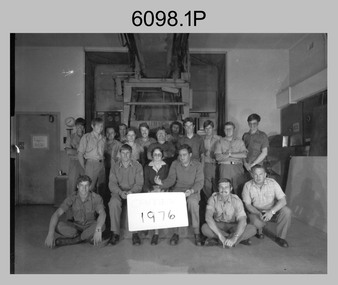
photograph - Camera Section, Lithographic Squadron at the Army Survey Regiment, Bendigo, 1976, 1978 and 1979
This is a set of four photograph of Camera Section, Lithographic Squadron, one of the Army Survey Regiment’s four squadrons, at Fortuna, Bendigo in 1976, 1978 and 1979. The main tasks undertaken by Camera Section’s technicians were photographic enlargements, reductions and duplication of map reproduction material, and processing of aerial photography. Photo .2P and its enlargement (.3P) was taken with Camera Section in front of the Klimsch Commodore camera on the 5th of October 1978, before its decommissioning. It was replaced with a new Klimsch model with computerised control, improved speed and consistent controlled output.This is a set of four photograph of Camera Section, Lithographic Squadron, Army Survey Regiment at Fortuna, Bendigo, c1970s. The black and white photographs were printed on photographic paper and are part of the Army Survey Regiment’s Collection. The photographs were scanned at 300 dpi. .1) - Photo, black & white, 1976, Back Row L to R: unidentified, Garry Hudson, unidentified, Greg Kidman, unidentified, Bob Chamberlain, Mick ‘Buddha’ Ellis, Zoe (Lisiewich) Ames, Bill Jones, Trevor Osborne, Dave Miles, Chris Osborne. Front Row L to R: Frank Lenane, Gavin Neilson, Joanne Green, Warren ‘Waldo’ Shirley, Peter Coombes, John Nicholls. .2) & .3) - Photo, black & white, 5th Oct 1978, Back Row L to R: CPL Bob Chamberlain, Greg Kidman, SSGT George Graham, Chris Osborne, John Nicholls, Frank Lenane, Terry Edwards, Bill Jones, CAPT Gary Kenney, Peter Imeson. Front Row L to R: CPL Warren ‘Waldo’ Shirley, SPR Mick ‘Buddha’ Ellis, CPL Garran Hill. .4) - Photo, black & white, 1979, Back Row L to R: WO2 George Graham, CAPT Stan Vote, Peter Imeson, Gary Tremain, Penny Knott, Zoe (Lisiewich) Ames, Di Chalmers, Rob Bogumil, Bill Jones, Rhys De Laine, Brian Fauth, John McCracken. Front Row L to R: SGT Ralph Chant, SGT Garran Hill, CPL Gavin Neilson, Frank Lenane, Paul Baker, SSGT Trevor Osborne.No personnel are identified. Each photo is annotated on the front. .1P annotated ‘1976’ .2P &.3P annotated ‘CAMERA SECT 5 Oct 1978 The Last of the old Klimsch’ .3P annotated ‘Camera ‘79’royal australian survey corps, rasvy, army survey regiment, army svy regt, fortuna, asr, litho -
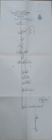
 Bendigo Historical Society Inc.
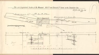
Document - MCCOLL, RANKIN AND STANISTREET COLLECTION: MONUMENT HILL CO., DEBORAH CO. LEASE ON DEBORAH LINE
Plan of Monument Hill Co., and Deborah Co. leases on the Deborah line. Black line drawing, showing longitudinal section. 'Deborah shaft to Nth Deborah 1100 ft ' noted in pencil . 'Nth Deborah shaft to Central Deb shaft 2000ft' in pencil. Other pencil notation on map re distance of leases. Map is attached to back page of booklet, rest of information missing.business, mining, mccoll rankin & stanistreet -
Kiewa Valley Historical Society
Folder - Mt Beauty Album, Premier Town Competition Mt Beauty July 1958
Mt Beauty & District Progress Association was formed when people of the Kiewa works system was to become a rate paying society no longer dependent on the State Electricity Commission of Victoria. 30 community members met on 4th December 1957 to form the new organisation.Mt Beauty and District Progress Association represented, protected and guided the community in arrangements for the future. The Association became more than a Chamber of Commerce. It represented a wide range of interests, a strong voluntary labor force largely responsible for the development of many of the on-going organisations It encompassed and set a strong program for tourism seen as being the security guarantee of the future. This was realised when Mt Beauty won The Victorian Premier Town contest in 1958. Thick brown cardboard cover with two steel rings for all 10 Appendix pages attached. The first section is not attached but inserted. This section with its own brown cardboard cover and bound by steel attachment, consists of the Application from the Mt Beauty & District Progress Association, July 1958 totalling 50 pages.The appendixes are labelled by number and have the relevant document(s) inside eg. mapsalex mccullough, mt beauty & district progress association, the victorian premier town -
 Bendigo Historical Society Inc.
Map - COMET MINE - LONGITUDINAL SECTION COMET MINE
Longitudinal section of the Comet Mine on the Hustler's Line of Reef Bulletin No 33, Plate No XXVI signed by H. S. Whitelaw, Underground Survey Office Bendigo, September 1913. Map shows datum lines, depths of levels, approximate boundaries and references to other plans. Note - Plates 4, 8, 13, 20, 26 and 31 form a Longitudinal Section from Fortuna Hustler's to Hustler's Consols Mine. Geological Survey of Victoriamining, parish map, hustler's line of reef, longitudinal section of comet mine bulletin no 33 plate no xxvi, h s whitelaw -
 Orbost & District Historical Society
pamphlets, Princes Freeway - Orbost Section, 1976
Opened by the Hon. J A Rafferty, Minister for Transport, 25 November 1976, the bridge was the first of four bridges to be built as part of the freeway bypass of Orbost. Construction cost $2.4 million. This construction was an important development along the Princes Highway corridor through East Gippsland. The original highway approached the Snowy River at a very poor alignment, and several serious accidents had occurred at the Orbost end. In times of heavy flood, the highway on both sides of the river had been cut by floodwaters and during the 1971 floods, the highest ever recorded, the river was a mile wide at the crossing. Construction of the bridges commenced in January 1975, with an expectation to open the bridge across the Snowy River as soon as possible. Less than two years later, on 25 November 1976, the bridge across the Snowy River was opened to traffic, allowing the old bridge to be demolished. The remainder of the Orbost Bypass, both the floodplain crossings and the eastern section around the township itself, was declared ‘Princes Freeway’ and opened to traffic in December 1977. (ref http://mrv.ozroads.com.au) The Country Roads Board was the government authority for the construction and maintenance of main roads in Victoria between 1913 and 1983. It was succeeded by the Road Construction authority on 1 July 1983 and later merged with the Road Traffic Authority on July 1 1989 to form the Roads Corporation. James Cameron, an Orbost farming pioneer and Member of the Legislative Assembly, fathered the Country Roads Board. The opening of this Snowy River Bridge was an important development in the accessibility to the township of Orbost.Three coloured Country Roads pamphlets for the 'Princes Freeway - Orbost Section". On the front is a coloured photograph of the new construction over the Snowy River at Orbost. Inside is a program for a ceremony for the opening of the new Snowy River Bridge. There is also a black print map of the project.