Showing 240 items
matching parish of sandhurst
-
 Bendigo Historical Society Inc.
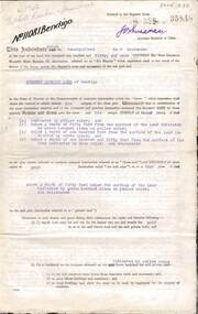
Document - INDENTURE, GOLD MINING LEASE 11081 CROWN AND HERBERT JACKSON LEED OF BENDIGO, MCCOLL, RANKIN AND STANISTREET COLLECTION, 21st September, 1940
... , Parish of Sandhurst. No. 11081. Net Area 24 acres, 3 roods, 3... of Bendigo, County of Bendigo, Parish of Sandhurst. No. 11081. Net ...Six page document plus map, dated 21st September 1940, between the Crown and Herbert Jackson Leed, for the land shown on the accompanying map 'indicated by yellow colour' Depths indicated on lease document. On map: Mining District of Bendigo, County of Bendigo, Parish of Sandhurst. No. 11081. Net Area 24 acres, 3 roods, 3 perches. Signed by Herbert Leed and ?Walsh, Warden Clerk, Bendigo. Map shows lease holding 11081 coloured yellow. Other leases: no's. 9882 11081, 11034, 11080. Streets: Fletcher Street, and Belle Vue Road. Gullies: Derwenters Mistake Bully and Pig Face Gully on lease 11081. Quarry Hill Recreation Reserve marked and some residential allotments. Water race indicated on map. On back of document: ; Deborah United Gold Mining Company No Liability of Charing Cross Bendigo is now the proprietor of the within described estate by transfer registered on 21st November 1940 and numbered 1795202.bendigo, mining, deborah united gold mine, herbert jackson leed, deborah united gold mining. major general sir winston joseph dugan -
 Bendigo Historical Society Inc.
Document - PETER ELLIS COLLECTION: REMARKS ON PROPOSED NATIONAL PARK AREA
... Area in Parishes of Mandurang and Sandhurst printed on white A4... national Park Area in Parishes of Mandurang and Sandhurst printed ...Some Introductory Remarks on the Proposed national Park Area in Parishes of Mandurang and Sandhurst printed on white A4 paper. Same as 8626.446 b with two front pages and the bottoms of some pages missing. An extra page at the end is titled POACEAE of the Bendigo Area. It lists grasses and reeds with their common names and scientific names.bendigo, parks and gardens, national parks, peter ellis collection, wild flowers -
 Bendigo Historical Society Inc.
Document - PETER ELLIS COLLECTION: REMARKS ON PROPOSED NATIONAL PARK AREA
... Area in Parishes of Mandurang and Sandhurst printed on yellow... National Park Area in Parishes of Mandurang and Sandhurst printed ...Some Introductory Remarks on the Proposed National Park Area in Parishes of Mandurang and Sandhurst printed on yellow foolscap paper. Short description of the area. Common names and scientific names of many plants that grow in the area. Some descriptions and localities mentioned. 4 1/2 pages of species (249) and families (56) mentioned.bendigo, parks and gardens, national parks, peter ellis collection, wild flowers -
 Bendigo Historical Society Inc.
Map - CAMPBELL COLLECTION: BENDIGO AND DISTRICT MAPS
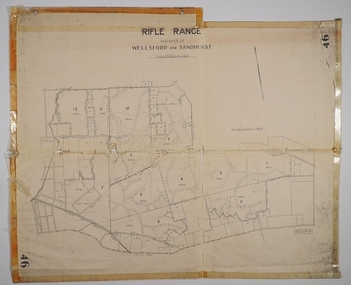
... Sandhurst Parish...Map. Rifle Range, Parishes of Wellsford and Sandhurst...MAP Bendigo allotments Bendigo Rifle Range Sandhurst Parish ...Map. Rifle Range, Parishes of Wellsford and Sandhurst. Scale 20 chains to 1 inch. Total area in plan is 5916 acres. Wallan and Bendigo Railway to Axedale Township and station 8 miles, to Longlea Railway Station 2 1/2 - 3 miles. Rifle Range. Compiled in W.P.B. from Assessment and Parish Plans, by H.A.D. 8-7-29H.A.D.(Darby).map, bendigo, allotments, bendigo rifle range, sandhurst parish, wellsford parish -
 Bendigo Historical Society Inc.
Map - CAMPBELL COLLECTION: BENDIGO AND DISTRICT MAPS, 8-7-29
... Map. Rifle Range, Parishes of Wellsford and Sandhurst... Bendigo allotments H.A.D.(H.A.Darby) Map. Rifle Range, Parishes ...Map. Rifle Range, Parishes of Wellsford and Sandhurst. Scale 20 chains to 1 inch. Total area by Planimeter 5916 acres. Wallan and Bendigo Railway line. Rifle Range. Axedale township and station 8 miles. To Longlea Ryl station 2 1/2 miles. To Epsom 1 1/2 miles. To Bendigo 3 miles. Compiled in W.P.D. from Assessment and Parish Plans by H.A.D 8-7- 29 (number 367 in map cupboard 1)H.A.D.(H.A.Darby)map, bendigo, allotments -
 Bendigo Historical Society Inc.
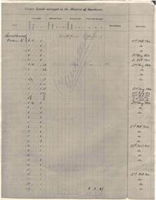
Document - RAILWAYS COLLECTION: CROWN LANDS SURVEYED IN DISTRICT OF SANDHURST
RAILWAYS COLLECTION -large cream -coloured paper photocopy of 'Crown Lands Surveyed in District of Sandhurst' x 2 Information has been entered into columns showing Parish, Town Lands, Suburban Lands, Country Lands, Total Lands Surveyed, Date of Survey, Date of Sale, most Dates of Sale are 1854 The documents have been cancelled.document -
Bendigo Historical Society Inc.
Map - CAMPBELL COLLECTION: BENDIGO AND DISTRICT MAPS, 18-6 29
Map. Longlea, Parishes of Axedale and Eppalock, scale 20 chains to 1 inch, total area 2372 acres. Prepared from Assessment Plan and Parish Plan by H.A. Darby18-6-29., Wondong, Heathcote and Sandhurst line (Railway). (number 386 in map cupboard 1)H.A.Darbymap, bendigo, agricultural lands -
 Bendigo Historical Society Inc.
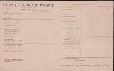
Document - KELLY AND ALLSOP COLLECTION: APPLICATION FOR LOAN ON MORTGAGE
Application for Loan on Mortgage. Messrs Allsop & Co., View Point, Sandhurst. Application has space for name, occupation, amount of Loan, number of years, interest rate, Where, number of Allotment, Section, parish or County, Area, Leasehold or Freehold. Applicants opinion as to value of Land alone. Number of Acres under Cultivation. How Land is watered. State Shire Valuation, Description of Buildings and materials used, Fences, Improvements. Application for Loan on Mortgage. Messrs Allsop & Co., View Point, Sandhurst. Application has space for name, occupation, amount of Loan, number of years, interest rate. Where, number of Allotment, Section, parish or County, Area, Leasehold or Freehold. Applicants opinion as to value of Land alone. Number of Acres under Cultivation. How Land is watered, State Shire Valuation, Description of Buildings and materials used, Fences, Improvements. Is applicant in occupation of Property, if not who is, and at what Rental. Are Buildings Insured, if so, what amount. Is the Property encumbered, is so, to what amount. Present marketable value of the whole, and names and addresses of two references. Authorization to deduct from the advance the costs of the Mortgage and Charges on obtaining the Loan. Note at the end - A Government plan, or sketch showing the position of the land and written valuation from an acknowledged Valuer. On the back is space for a Valuator's Report and a note to the Valuators, also a Proposal for Loan on Mortgage with details of the loan. Date on the form is 188-.business, stockbroker, kelly & allsop, kelly and allsop collection - application for loan on mortgage, allsop & co. -
 Bendigo Historical Society Inc.
Document - INDEXES
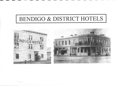
Indexes Includes Names from the 1856 Petition Bendigo and District Hotels Final Marunari List Terry Davidson 1871 - 2018 Index to RHSV Bendigo Branch Newsletters Nov. 1971 - July 2002 Helen Mainka 1954 Bendigo Business District Directory McConnell’s Street and general Directory Date unknown Victorian Directory 1904 Bendigo and District Directory 1904 – 1905 Bendigo district general Directory 1859 City of Bendigo Historical Information Bendigo Hotels compiled by Len Bennetts Hotels of Bendigo and District Compiled by Len Bennetts Sandhurst Land Sales 1854 – 1856 Ralph Birrell Chronicles of Bendigo from the Bendigo Advertiser Christmas Supplement December 22 1904 Some Photographers 1850 – 1900. Including some Bendigo Photographers 1854 – 1958 St. Patrick’s Annual Sports advertisers. Date Unknown Fatalities listed in bendigo Advertiser 1888-1935. Two copies One by year. One alphabetical. District statistics - Mayors and Shire Presidents, Bendigo Football League Premiers 1880- 1987, Sportstar of the year 1965-1987 Plans of townships and Parishes held at Ducley House. From the Bendigo Lands Office 1976. -
Bendigo Historical Society Inc.
Map - PARISH OF STRATHFIELDSAYE : COUNTY OF BENDIGO, 1-10-19
Map. Parish of Strathfieldsaye, County of Bendigo, Wellsford, Sandhurst, Sedgwick, Eppalock, Axedale. Photo-Lithographed at the Department of Lands and Survey, Melbourne by W.J.Butson, 1-10-19. Price 1/-. By authority A.J. Mullett, Government Printer, Melbourne. (number 34 in map cupboard 1)A.J. Mullett, Govt. Printer, Melbourne.map, bendigo, strathfieldsaye -
 Bendigo Historical Society Inc.
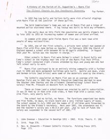
Document - A HISTORY OF THE PARISH OF ST AUGUSTINE'S: MYERS FLAT
A history of the Parish of St Augustine's Myers Flat - The oldest Church in the Sandhurst Diocese by Fay Parker. A 7 loose- paged printed document covering - early history of Myers Flat; Myers Flat school; building and dedication of church/school (1864); enrolments of children; fund raising; Myers Flat Cricket Club; hotels in Myers Flat (& Brewery)); choir and missions at St Augustine's; teachers and students (incl. names of students in last years); restoration (1964/5); National Trust classification (1970); priests over the years ; names of families still attending St Liborious and St Augustine's with original forebears among first parishioners; bibliography; final page is a poem about ''St Augustine's'' written by Aimee Rees to celebrate the centenary of St Augustine's. B. Single typed page beginning ''My grandmother Anne Rocks was born at Myers Flat on November 2nd, 1867 '' with further information re great grandmother and great grandfather and (10) children of that family - no author given for this page (but could be Fay Parker???)Fay Parkerchurch, history, st augustines myers flat, myers flat school, cricket club, brewery, myers flat cricket club, st liborious, st augustine's, anne rocks. rev. dean hayes. right rev. bishop goold. rev. dr backhaus. st ausustine's poem. -
Bendigo Historical Society Inc.
Map - BENDIGO AND DISTRICT PARISH MAPS, 21-10-26
Map. Sandhurst, County of Bendigo, City of Bendigo, Strathfieldsaye, Mandurang, Marong, Nerring, Borough of Eaglehawk, Township of Kangaroo Flat, Lockwood, Huntly, Epsom, Wellsford. By Authority H.J. Green, Government Printer, Photo-Lithographed at the Department of Lands and Survey, Melbourne bj W.J Butson 21-10-26,Price 1/-. (number 13 in map cupboard 1)By Authority H.J. Green, Govt. Printermap, bendigo, sandhurst -
 Bendigo Historical Society Inc.
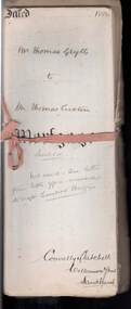
Document - CONNELLY, TATCHELL, DUNLOP COLLECTION: LEASE HOLD MORTGAGE MR. THOMAS GRYLLS TO THOMAS LUXTON ESQ
a. Leasehold mortage documents Mr. Thomas Grylls to Thomas Luxton Esq. Registered 16th. November, 1888, No. 96127. Parish of Dingee, County of Bendigo, 224 acres 3 roods and 9 perches. Vols 256, Folio 51104, Vols 279, Folio 55715, Vols 307, Folio 61362, Vols 416, Folio 83186. Mortgage document, various letters, notes, calculations of costs pertaining to above transaction enclosed in file.cottage, miners, connelly, tatchell & dunlop, thomas grylls, thomas luxton, sharebroker, h. harrison, titles, sandhurst, dingee -
 Bendigo Historical Society Inc.
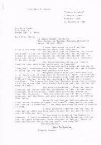
Document - CORRESPONDENCE: ESPIE AND STONE FAMILIES (LOCKWOOD)
1991 correspondence re Espie and Stone families (Lockwood) from Alex H Stone. Also mention of Nicholas and Johson families (Tasmania). Family history in letter and accompanying letter is a 'List of Material being sent' nominating 13 items. This list is incomplete - there is now attached : Petition (1857); Parish plans 4 pages; 3 copies of photos - Queen's Hotel, Lockwood, Lockwood Post Office, Lockwood South Post Office (Happy Jack Hotel).List of Postmasters at Lockwood from 1856.person, individual, samuel espie, espie, nicholas stone and johson families. mrs margaret m. stone of duntroon helbourne. etloe bothwell. william nicholas, anne hope, bendigo creek, sandhurst, lockwood county of bendigo, lockwood south post office opened 1909, happy jack hotel, queens head hotel lockwood, 1865 post master lockwood samuel espie, alex h. stone. -
 Bendigo Historical Society Inc.
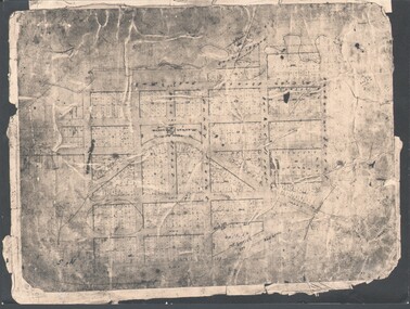
Photograph - WES HARRY COLLECTION: TOWNSHIP OF SANDHURST, 1854
Photograph of the Parish Plan of the Township of Sandhurst in 1854. It covers the area of the CBD from Mitchell (not named) to Bernal Streets and from the Bendigo Creek to Mollison St. ( other than Pall Mall and McRae streets, none of these parallel streets are named)place, bendigo, first survey, sandhurst, first survey, bendigo creek -
 Bendigo Historical Society Inc.
Document - OLD TOM LEASE MAP
Hand Drawn map of Old Tom Lease - Parish of Huntly, County of Bendigo, Mining district of Sandhurst.place, land, mining -
 Bendigo Historical Society Inc.
Document - LANDS OFFICE : SPECIAL LAND SALES IN SANDHURST 1861 TO 1864, 1861 - 1864
Document: light brown cover, hard cover journal. Contains details of crown lands surveyed and sold in the District of Sandhurst. Index and 217 pages. LH page: parish, town lands, suburban lands, country lands, total lands surveyed, date of survey. RH page: date of sale, by auction, by selection, price per acre, total amount, names of purchasers. On spine: '2' in red, ' sales Bendigo 1861 - 1864'Lands Officeplace, bendigo, land sales, bendigo, sandhurst, land sales, land surveyed -
Bendigo Historical Society Inc.
Map - SANDHURST SHEET 3, 27/05/1925
... Map: sandhurst sheet 3. Parish plan ( number 202 in Map... Bendigo parish plan Sandhurst Map: sandhurst sheet 3. Parish plan ...Map: sandhurst sheet 3. Parish plan ( number 202 in Map Cupboard 1)map, bendigo, parish plan, sandhurst -
Bendigo Historical Society Inc.
Map - SANDHURST SHEET 1, No date visible
Map: Sandhurst ,County of Bendigo sheet 1. Parish plan ( number 201 in Map Cupboard 1)map, bendigo, city streets, sandhurst -
Bendigo Historical Society Inc.
Map - SANDHURST SHEET 2, No date visible
Map:Sandhurst, County of Bendigo Sheet 2. Parish plan, Eaglehawk. ( number 200 in Map Cupboard 1)map, bendigo, city streets, sandhurst -
Bendigo Historical Society Inc.
Map - SANDHURST SHEET 3, No date visible
... Map: Sandhurst sheet 3. Parish plan ( number 199 in Map... Bendigo city streets Sandhurst Map: Sandhurst sheet 3. Parish plan ...Map: Sandhurst sheet 3. Parish plan ( number 199 in Map Cupboard 1)map, bendigo, city streets, sandhurst -
Bendigo Historical Society Inc.
Map - SANDHURST SHEET 4, January 1947
... Map: Sandhurst sheet 4. Parish plan ( number 198 in Map... Bendigo city streets Sandhurst Map: Sandhurst sheet 4. Parish plan ...Map: Sandhurst sheet 4. Parish plan ( number 198 in Map Cupboard 1)map, bendigo, city streets, sandhurst -
Bendigo Historical Society Inc.
Map - SANDHURST SHEET 5, Circa 1940's
... Map: Sandhurst sheet 5. Parish plan ( number 197 in Map... Bendigo city streets Sandhurst Map: Sandhurst sheet 5. Parish plan ...Map: Sandhurst sheet 5. Parish plan ( number 197 in Map Cupboard 1)map, bendigo, city streets, sandhurst -
Bendigo Historical Society Inc.
Map - SANDHURST SHEET 6, 1947
... Map: Sandhurst sheet 6. Parish plan ( number 196 in Map... Bendigo city streets Sandhurst Map: Sandhurst sheet 6. Parish plan ...Map: Sandhurst sheet 6. Parish plan ( number 196 in Map Cupboard 1)map, bendigo, city streets, sandhurst -
Bendigo Historical Society Inc.
Map - BENDIGO (COUNTY), Circa 1870's
Map:Plan showing the whole of the County of Bendigo-- attached handwritten sheet in the top left hand corner-'Proclaimed Commons Sandhurst District'. Also attached is a separate plan of the parish of Kimbolton (number 262 in map cupboard 1)map, bendigo, parish plan, bendigo, proclaimed commons -
Bendigo Historical Society Inc.
Map - SANDHURST (PART), Circa 1880's
Map: Parish plan showing an area from McKenzie/View streets to Long Gully ( number 232 in Map Cupboard 1)map, bendigo, parish plan, sandhusrt, mckenzie street , view street, long gully -
Bendigo Historical Society Inc.
Map - CITY OF SANDHURST RESURVEY SHEET 2, 23/05/1881
... Map City of sandhurst Resurvey, sheet 2. Parish plan... Bendigo parish plan Sandhurst Resurvey Map City of sandhurst ...Map City of sandhurst Resurvey, sheet 2. Parish plan ( number 231 in Map Cupboard 1)map, bendigo, parish plan, sandhurst resurvey -
Bendigo Historical Society Inc.
Map - SANDHURST (PART), Circa 1880's
... Bendigo parish plan Sandhurst Belle Vue Road Barnard street Maple ...Map: Parish plan covering the area from Belle Vue Rd. to Barnard St. and Maple St to Short St. ( number 230 in Map Cupboard 1)map, bendigo, parish plan, sandhurst, belle vue road, barnard street, maple street , short street -
Bendigo Historical Society Inc.
Map - CITY OF SANDHURST SHEET NO.6, 25/04/1882
... Map: City of Sandhurst sheet No. 6. Parish plan... Bendigo parish plan Sandhurst Map: City of Sandhurst sheet No. 6 ...Map: City of Sandhurst sheet No. 6. Parish planmap, bendigo, parish plan, sandhurst -
Bendigo Historical Society Inc.
Map - CITY OF SANDHURST RESURVEY SHEET NO. 3, 13/05/1881
... Map: City of Sandhurst Resurvey sheet No. 3. Parish plan.... Bendigo parish plan Sandhurst Resurvey Map: City of Sandhurst ...Map: City of Sandhurst Resurvey sheet No. 3. Parish plan.map, bendigo, parish plan, sandhurst, resurvey