Showing 369 items matching " price list"
-
 Phillip Island and District Historical Society Inc.
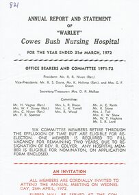
Programme, Annual Report and statement of "Warley" Cowes Bus Nursing Hospital 1972 and Diamond Jubilee celebrations 1983
HistoricalReport is an A4 cream sheet with black and red print., folded in half. Office bearers are listed and financial, secretary's and Ladies Auxiliary reports are included. Two single sheets inside have meeting information and prices of subscriptions. Celebration is cream cardboard, folded in half with blue print and photo of the original hospital on cover. The program for the day is inside.Annual Report and statement of "Warley" Cowes Bush nursing Hospital for the year ended 31st March 1972. "Warley" Bush Nursing Hospital Diamond Jubilee celebration Sunday, December 4th ,1983hospital, warley hospital -
 Flagstaff Hill Maritime Museum and Village
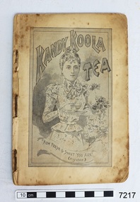
Book - Cookbook, The Kandy Koola Cookery Book, 1898
This is a cookbook of family recipes and promotes products available for purchase at that time. The products include Kandy Koola, Nestle, Usher’s Whiskey and O.K. Kandy Koola ran an advertisement in the West Gippsland Gazette on 2 May 1911 promoting its tea as perfect for a picnic. The text reads “Picnicking. All as hungry as hunters – made a fire of small twigs – put on our billy of fresh spring water – and waited. Soon bubble, bubble, bubble and the billy boiled. In goes the pure Kandy-Koola Tea. Tea! Tea is not the word – it tasted like nectar! One cup, two cups, three cups – then had to make a fresh billy full. Lazed away the rest of the day sipping our Kandy Koola and chatting. How good indeed! “All grocers sell Kandy Koola Tea. It is pure leaf, selected and blended with the greatest care and skill. Ask your grocer for Kandy Koola . Sold in three grades, i.e. red, blue and green packets” A copy of this cookery book is in the Monash University Library’s Rare Books Collection and has a cover with red printing on a cream background. The price stamp on the corner of the cover is “One Shilling” and is under an image of a crown. The book has 71 pages. It is listed as being published in Melbourne, 1898. The comment given is “This is an early example of an Australian cookbook printed as a product promotion, ‘published by the proprietors of Kandy Koola Tea for presentation to the ladies of Victoria, with compliments.’ “ Flagstaff Hill also has a green Kandy Koola Tea tin in our Collection This Kandy Koola Cookery Book is an example of the recipes, foods, manufacturers, advertisements available and used in the late 19th century in Australia’s colonial times. Food types, preparation and cooking methods show those available to housewives in those times.Book, cookbook, The Kandy Koola Cookery Book and Housewife’s Companion. Small book, pages bound with staples, contained in a black card cover (original outer covers is missing). Pages start at number 11, which is an advertisement for Kandy Koola Tea. The book includes a wide variety of recipes promoting products of Kandy Koola, Nestle, Usher’s Whiskey and O.K. There are pages of line drawings of a ‘Chinese Tea Plantation’ and ‘Natural Bridge in Virginia U.S.A.’ Advertisements include a drawing of a kangaroo. flagstaff hill, warrnambool, shipwrecked coast, flagstaff hill maritime museum, maritime museum, shipwreck coast, flagstaff hill maritime village, great ocean road, cookery book, cookbook, australian cookbook, 19th century cookbook, colonial cookbook, domestic, book, promotional cookbook, o.k. preserves manufacturer, nestle, usher’s whiskey, image of chinese tea plantation, image of natural bridge in virginia u.s.a., cook book, kandy koola cookery book -
 Ringwood and District Historical Society
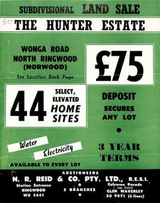
Flyer, Land Sale Brochure, The Hunter Estate, North Ringwood, Vic. - circa 1960
... , with separate attachment listing lot number prices.... facilities and services, with separate attachment listing lot number ...Bi-fold land sale advertisement for The Hunter Estate, North Ringwood, including terms of sale, area map, layout of the estate, and summary of local facilities and services, with separate attachment listing lot number prices.Subdivision includes Wonga Road, Hunter Avenue (later Graeme Avenue), Panfield Avenue, Hendra Grove, and Mullum Mullum Road. Agent - N.R. Reid & Co. Pty. Ltd., Station Entrance, Ringwood. (Phone) WU 6661. -
 Kiewa Valley Historical Society
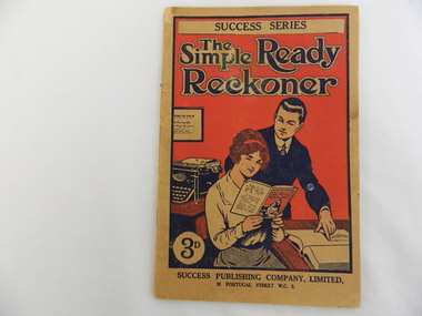
Book - Home Business, Success Publishing Company, Ltd, The Simple Ready Reckoner - Success Series by Charles Platt
The picture on the front of this book depicts the female as the weaker sex unable to understand or work out numbers.This book may have been used in a Kiewa Valley business or farm.Thin soft covered red, black, fawn, brown book with picture of a female sitting down looking at this book while the male points to the ledger as if to show her how (the book) can be used. The book has a list of numbers - a Discount Table - giving how much a number of items cost at a given price. eg. 10 books at 3/- each = 30/-business, money, accounting -
 Warrnambool and District Historical Society Inc.
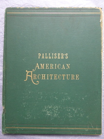
Book, Palliser's American Architecture, 1888
... and diagrams and a list of the prices for the designs in the book... illustrations, plans and diagrams and a list of the prices ...This book contains many late 19th century designs from the office of the American architects Palliser, Palliser and Co. The book was owned by John Crawley. He was the Shire of Warrnambool Engineer from 1895 to his death in 1935. He succeeded his father, also John, beginning work at his father's office in 1885. This book is of antiquarian interest because it has many examples of the designs of the private and public buildings in U.S.A. in the late 19th Century. It is also important because it belonged to John Crawley, a member of the Crawley family, prominent in administrative and technical positions in the Shire of Warrnambool in the 19th and 20th centuries.This is a hard cover book of 104 pages. The cover is green with gold borders and gold lettering. The book has come apart from its binding and the lower part of the spine covering is missing. The book has many black and white illustrations, plans and diagrams and a list of the prices for the designs in the book. The inscription is hand written in black ink. There is some evidence of silverfish damage.J Wm Crawley Junior 12.12. 98crawley family, shire of warrnambool, john william crawley junior -
 Eltham District Historical Society Inc
Document - Property Binder, 895 Main Road, Eltham
Folder: 895 Main Road, Eltham Contents Listing 1. Certificate of Title; Vol. 8424, Fol. 334, 5 February 1963 2. Certificate of Title; Lot 2, Plan of Subdivision No. 63242, Parish of Nillumbik, Vol. 8479, Fol. 283, 18 May 1964 (Eltham War Memorial Trust) 3. Newspaper article: Extensions to shire offices will benefit all, by Fab Calafuri, Diamond Valley News, Tuesday, July 8, 1986, p6 [Reverse side, p5, Residents rally to save dam by Helen Gillman about Peck’s Dam in Napier Street, Montmorency] 4. Office memo: Temporary Shutdown of Water Supply Shire Offices – Tuesday 9 March 1993; Anthony Guzzo, 5 March 1993 – Melbourne Water advice due to works on new library 5. Plan of Old Municipal Offices, date and creator unknown 6. Newspaper clipping: Move to convert shire office for police use, by Jodie Haythorne, Diamond Valley News, May 1995 7. Newspaper clipping: Sale of Eltham office / Removal of Question time; Nillumbik Happenings, Mountain Views, 15 May 1995 8. Newspaper clipping: Bid for TAFE campus, Mountain Views, 25 September 1995, p8 9. Newspaper clipping: Will the former Shire of Eltham offices become a TAFE college?, The Advertiser, circa September 1995 [Reverse side; Jezza! Photo of football legend Alex Jesaulenko at Watsonia RSL also Advertisement: Maternal and Child Health Centre Timetable] 10. Newspaper clipping: Eltham may get TAFE campus in shire offices, by Fiona Kaegi and Natalie Town, and Nillumbik set for rate cuts, Diamond Valley News, circa September 1995 [Reverse side; Art for hope – article about artist Damien Curtain at Hurstbridge Primary School] 11. Newspaper clipping: More talks on TAFE, The Advertiser, Tuesday, October 17, 1995, p3 – includes photos of Nillumbik Chief Commissioner Don Cordell, Box Hill College of TAFE Executive Director Andrew Jackson and Niillumbik CEO Barry Rochford; Eltham MP Wayne Phillips with Eltham Chamber of Commerce President Norm Williams and Rotary Club of Eltham President Peter Bishop; Eltham College principal John Brennan with St Helena Secondary College head Ken Cunningham and Eltham High School principal Ron Edwards. [On reverse, p4, Sorry sag of botched relations, Jock Kyme] 12. Newspaper clipping: Eltham hails TAFE take-over, by Fiona Kaegi and Council to hold regular briefings, Diamond Valley News, 18 October 1995 13. Newspaper clipping (photocopy): Why no council office at Eltham?, Mark Burns, Letters, Diamond Valley News, 18 October 1995 14. Newspaper clipping: Future of Eltham office?, Mountain Views, Monday, October 23, 1995, p8 15. Newspaper clipping: Council seeks opinions on former shire offices, by Fiona Kaegi, Diamond Valley News, 25 October 1995 16. Newspaper clipping: Shire office move, The Advertiser, December 1995 17. Newspaper clipping: Former shire offices up for sale; possibly Diamond Valley News, December 1995 18. Newspaper clipping: Agents to sell shire office, Mountain Views, Monday, December 18, 1995, p8 19. Newspaper clipping: Advertisement; Nillumbik Shire Council Proposed Sale or Lease of Eltham Municipal Offices, Diamond Valley News, 10 January 1996 20. Newspaper clipping: No Submissions on Eltham Shire Offices, Diamond Valley-Whittlesea Advertiser, 30 January 1996, p1 21. Photocopy: Minutes of Ordinary Council Meeting, 31 January 1996, 7.4 Sale or Lease of Former Eltham Municipal Offices 22. Photocopy: Letter HTW Valuers to Nillumbik Shire Council, Valuation of former Eltham Municipal Offices at $1.45 million, 31 January 1996 23. Newspaper clipping: New G’boro, Eltham places, Diamond Valley-Whittlesea Advertiser, Tuesday, March 26, 1996, p4 [on reverse, p3, ALP Faithful at Montsalvat] 24. Newspaper clipping: Legal costs a hurdle for action group, by Laeta Antonysen, Diamond Valley News, 16 April 1996 25. Photocopy (91 pages): Tender Documents for purchase of Former Eltham Shire Offices 895 Main Road, Eltham, Prepared for Nillumbik Shire Council, Maddock Lonie & Chisholm, Melbourne. Tenders close at 3.00pm on 24 April 1996 26. Newspaper clipping (Photocopy): Building’s asbestos riddle. By Fiona Kaegi, Diamond Valley News, 26 June 1996 27. Photocopy: Minutes of Ordinary Council Meeting, 26 June 1996, 11.43/96 Sale of Eltham Offices, Main Road, Eltham 28. Media Release (Photocopy of facsimile from Barry Rochford, CEO): Community Facilities in New Gateway to Eltham, 28 June 1996 29. Photocopy (A3): TPA1 – Site Plan 1:200 Proposed Convenience Centre At Main Road Eltham, Baldasso Cortese Pty Ltd Architects, Collingwood, July 1996 30. Newspaper clipping: ‘Whopper’ For Eltham?, Letters, Sigmund Jorgensen, The Advertiser, Tuesday, July 2, 1996, p3 31. Newspaper clipping: Ex-shire offices to go, by Fiona Kaegi, Diamond Valley News, 3 July 1996, p1 32. Photocopy Newspaper clipping: Unsuccessful bidders criticise sale of offices, by Fiona Kaegi, Diamond Valley News, 10 July 1996 33. Newspaper clipping: Insensitive proposal, Sue Dyet, Letters, Diamond Valley Newsm 17 July 1996 34. Photocopy: Minutes of Ordinary Council Meeting, 17 July 1996, 7.116/96 Sale of Eltham Offices, Main Road, Eltham 35. Newspaper clipping: Former shire office sale angers residents, Diamond Valley News, 30 July 1996, p3 36. Newspaper clipping: Eltham Offices Demolition, ‘You can’t demolish city hall’, The Advertiser, Tuesday, July 30, 1996, pp14-15 features photos of Eltham protestors, Thelma Barkway, Harry Gilham, Jenni Mitchell, Jock Kyme and David Essex 37. Photocopy (A3): TPA1 – Site Plan Proposed Convenience Centre, Main Road, Eltham, Graeme Bentley Landscape Architects, August 1996 38. Newspaper clipping (Photocopy): Letters; Disbelief at plans, Margaret Jennings; Lack of respect, Mike Jansz; Community opinion, Sigmund Jorgensen, Diamond Valley News, circa August 1996 39. Newspaper clipping (Photocopy): ‘There was no conflict of interest’, The Advertiser, Tuesday, August 4, 1996 40. Newspaper clipping: Chamber supports plans, by Jodie Guest, Diamond Valley News, 7 August 1996 41. Newspaper clipping (Photocopy): Letters; Adding to the price, Kelly Fitzpatrick; Area being torn apart, Jenni Bundy, Diamond Valley News, 7 August 1996 42. Newspaper clipping: Labor joins battle to save offices, by Fiona Kaegi, Diamond Valley News, (7?) August 1996 43. Newspaper clipping: Letters to the Editor; ‘Atrocious assault of commercialism’, Lois Loftus-Hills, The Advertiser, Tuesday, August 13, 1996, p9 44. Newspaper clipping: Letters; Roll up for the show, Kahn Franke; Thanks for turn-out, Margaret Jennings; Way past time, Jenni Bundy; Angry at the vandalism (continued p13 missing), Diamond Valley News, August 14, 1996, p12 45. Newspaper clipping: ‘Enough is enough’ states John Cohen; Letters to the Editor, Diamond Valley-Whittlesea Advertisers, Tuesday, August 20, 1996, p2 [Reverse, p1, Trade boost at Diamond Creek] 46. Newspaper clipping: Public viewing, Diamond Valley News, 4 September 1996, p 47. Newspaper clipping: Letters; Chiefs must resign, Gayle Blackwood; Time to have your say, Margaret Jennings; Sensible balance, Gwen Jakins; Recycling: a fine example, Grace Mitchell; Limits on site use, Stephen Clendinnen; Diamond Valley News, 4 September 1996, p4 48. Newspaper clipping: Letters; A lasting memorial, Ken and Laurel Eckersell; Stripping assets, Jack Lawson; Diamond Valley News, 4 September 1996, p29 49. Newspaper clipping: Letters; Nillumbik: in the eye of the beholder, Sigmund Jorgensen; ‘Crying inside’ over Eltham Shire office, Grace Mitchell; The Advertiser, Tuesday, September 10, 1996, 2 50. Newspaper clipping: Public Notice; Notice of an Application for Planning Permit, Dallas price Homes Pty Ltd, Diamond Valley News, 11 September 1996 51. Newspaper clipping (Photocopy): Timing was the problem: chief, by Laeta Antonysen, Diamond Valley News, 11 September 1996 52. Newspaper clipping: Letters; Architectural monstrosity, Jenni Bundy; Bargain price, Gavin Gray; Paying for road works, Sue Dyet; Diamond Valley News, 11 September 1996 [ on reverse, articles on Queen’s Guide Nicola Blay (photo) and Plenty River and Diamond Creek waterways] 53. Newspaper clipping: Eltham Hub Plans on Show, The Advertiser, Tuesday, September 17, 1996, p1 54. Newspaper clipping: Bleeding halted: Commish and Letters; Sigmund’s credibility gap, David Nolte; ‘Double standards’, Ros Harris, The Advertiser, Tuesday, September 17, 1996, p3 55. Newspaper clipping: Gateway to the future; Plans on display, public comments sought, by Laeta Antonysen, Diamond Valley News, September 18, 1996, p8 [Reverse, p7, Policy limits event signs, and, Council ‘arrogant’ on ward option: MP] 56. Newspaper clipping (Photocopy): 19 on council inquiry list, by Jodie Guest, Diamond Valley News, 18 September 1996 – about council listing 19 people who are only to be dealt with directly by CEO, Barry Rochford 57. Newspaper clipping (Photocopy): Eltham is wonderful, Sigmund Jorgensen, Letters, The Advertiser, Tuesday, September 24, 1996, p4 58. Objection to Grant of Planning Permit (Photocopy): Russell Yeoman per Eltham District Historical Society Inc. re application 960376 for petrol station, convenience shop, retail shop, etc to be issued to Dallas price Homes Pty Ltd, 25 September 1996 59. Newspaper clipping (Photocopy): Public meeting, Eltham Gateway Action Group – to discuss latest plans to develop former shire office site on Sunday 4 September 1996; publication unknown, possibly Diamond Valley News 60. Newspaper clipping: Minister orders sale probe, by Jodie Guest, Diamond Valley News, Wednesday, October 12, 1996, p1 61. Newspaper clipping: Letters; Headline could mislead, Wayne Phillips, Member for Eltham, The Advertiser, Tuesday, October 8, 1996, p3 62. Newspaper clipping: Letters; Few jobs for young, Margaret Jennings; The whole truth, Alan Ramsay, Diamond Valley News, October 9, 1996, p12 63. Newspaper clipping: Public outcry at Abbott veto with ‘reserve power’; 200 residents yell abuse as commissioners give ok to Eltham service station, The Advertiser, Tuesday, October 15, 1996, p1 64. Newspaper clipping: Letters; Eltham Hub briochure has ‘trees that are a fiction’, Lois Lofus-Hills, The Advertiser, Tuesday, October 15, 1996, p2 65. Newspaper clipping: Shrewd tactics row, by Jodie Guest, Diamond Valley News, Wednesday, October 16, 1996, p1 66. Newspaper clipping: Residents have their say on former shire offices, by Jodie Guest, and, Anger over reserve power, by Laeta Antonysen, Diamond Valley News, Wednesday, October 16, 1996, p9 67. Newspaper clipping: Office sale report will not be made public, Diamond Valley News, October 23, 1996 [Reverse, article featuring Youth development officer, Ian Patching] 68. Newspaper clipping: Letters; Happening in a hurry, Peter Dodds; Development unsuitable, Mark Burns; Vale those dreamers, Sigmund Jorgensen, Diamond Valley News, October 23, 1996, two pages unidentified 69. Newspaper clipping: Group to fight council decision on office site, by Laeta Antonysen, Diamond Valley News, October 26, 1996 – re Eltham Gateway Action Group taking Council to the Administrative Appeal Tribunal over approval of controversial development [Reverse, article on Bend of Islands place name] 70. Newspaper clipping: Three days allowed to hear objection, by John Dubois, Diamond Valley New, December 4, 1996 71. Newspaper clipping: Letters; Site traffic dangers, Frank Burgoyne; Thanks for support, Margaret Jennings, Diamond Valley News, noted in pen as 8 December 1996 though probably 11 December 1996 [Reverse, What about that link, asks council, by Natalie Town – about ring road between Greensborough and Ringwood] 72. Newspaper clipping: Minister to rule on proposal, by Fiona Kaegi, Diamond Valley News, December 18, 1996 73. Report (Photocopy, 31 pages): Convenience Centre Development Proposal: Italian Cypress at Former Eltham Shire Offices Site, Main Rd. Eltham, Graeme Butler & Associates, 1997 74. Newspaper clipping: People unite to battle project, by Fiona Kaegi, Diamond Valley News, February 19, 1997 75. Letter (Photocopy): Ms B Martin to Fiona Kaegi to be submitted for Letters to the Editor, Diamond Valley News 26 March 1996 edition 76. Letter (Photocopy): Thelma Barkway to Fiona Kaegi to be submitted for Letters to the Editor, Diamond Valley News 26 March 1996 edition 77. Newspaper clipping: Legal Battle, by Fiona Kaegi, Diamond Valley News, Wednesday, April 2, 1997 78. Newspaper clipping: Site Row Saga, by Laeta Antonysen, Diamond Valley News, Wednesday, April 9, 1997 79. Newspaper clipping: Community fears loss of heritage, by Laeta Antonysen, Diamond Valley News, April 9, 1997 80. Newspaper clipping: Debate erupts over service station plan, by Laeta Antonysen, Diamond Valley News, April 9, 1997 [Reverse, ‘No’ to rates hike proposal] 81. Newspaper clipping: Letter to the Editor; “Your front-page last week is considerable inaccurate … a surplus of $14,000 is expected at 30 June 1977.”, Robert Marshall, The Advertiser, April 28, 1997, p1 82. Newspaper clipping: $1.1m Debt Plan, by Fiona Keagi, Diamond Valley News, Wednesday, April 23, 1997, p1 and continued on p24, Shire to defer works programs 83. Newspaper clipping: Blast for Council, by Laeta Antonysen, Diamond Valley News, Wednesday, April 30, 1997, p1 and continued on p7, ‘Experts’ oppose plans for shire site. 84. Newspaper clipping: Photo – Uncertainty: the future of the former Eltham Shire office site is still to be decided by Planning Minister Rob Maclellan., Diamond Valley News, April 30, 1997 [ Reverse; Not your average convenience store, by Laeta Antonysen] 85. Newspaper clipping: Shire site decision soon, Diamond Valley News, May 28, 1997 86. Newspaper clipping: Letters to the Editor; Features to protect, Ken Eckersell, Diamond Valley News, June 4, 1997 87. Newspaper clipping: Costly bun fight over shire offices, by Laeta Antonysen, Diamond Valley News, July 2, 1997 [reverse, Montsalvat plans season of festivals, by Fiona Kaegi] 88. Newspaper clipping: Shire office shemozzle, Diamond Valley News, July 2, 1997 – provides a brief timeline of events June 1996 to April 22, 1997 89. Newspaper clipping: Law Suit Threat, by Fiona Kaegi and Laeta Antonysen, Diamond Valley News, Wednesday, July 9, 1997, p1 90. Newspaper clipping: Report rejects store plan, and, Residents with panel, Diamond Valley News, Wednesday, July 9, 1997 91. Newspaper clipping: Councillors meet Shell developer, by Laeta Antonysen, Diamond Valley News, July 30, 1997 92. Newspaper clipping: Deadline extended to allow more talks, by Fiona Kaegi, Diamond Valley News, August 8, 1997. Also Curves to stay in link road about Nillumbik’s realignment plans for Diamond Creek’s ‘windy mile’ [Reverse, Shire tightens grants scheme] 93. Newspaper clipping: $10m option for shire office site, by Laeta Antonysen, Diamond Valley News, September 10, 1997 94. Newspaper clipping: New plan for shire office site, by Laeta Antonysen, and , Council refuses to do trade with developer, Diamond Valley News, September 17, 1997, p12 [ Reverse, p11, Mixed reaction to kangaroo culling] 95. Newspaper clipping: Gateway plan review, by Laeta Antonysen, Diamond Valley News, October 22, 1997, p3 96. Newspaper clipping: Top planner calls for rethink on office site, by Jodie Guest, Diamond Valley News (includes photo of John Pizzey) 97. Newspaper clipping: Opposition offers help on planning, by Jamie Duncan, Diamond Valley News, November 5, 1997, p3 (includes photo of Opposition Leader John Brumby and Nillumbik Shire President Robert Marshall at the Eltham Gateway site) 98. Letter (Photocopy): Russell Yeoman, Secretary, Eltham District Historical SAociety to Mr B. Rochford, CEO, Nillumbik Shire Council, 15 November 1997 with specific reference to the health of the three “Shillinglaw” trees 99. Newspaper clipping: Puzzlement over delay on office site, by Laeta Antonysen, Diamond Valley News, November 19, 1997 100. Newspaper clipping: Developer pulls out, by Laeta Antonysen, Diamond Valley News, December 10, 1997, p3, and, Council uproar over officers [Reverse, p4, Final victory – announcing resignation of Jenni Mitchell as president of Etham Gateway Action Group] 101. Newspaper clipping: Letters; Asset of pride, Sigmund Jorgensen, Diamond Valley News, January 14, 1998 102. Newspaper clipping: Minister ‘no’ to plan, by Laeta Antonysen, Diamond Valley News, February 11, 1998, p3 103. Newspaper clipping: Shell shocked as Eltham planning protest is upheld, by Gabrielle Costa, date and publication unknown; possibly The Age, February 1998 104. Newspaper clipping: Land review, by Laeta Antonysen, Diamond Valley News, April 1, 1998 105. Newspaper clipping: Bid to move shire offices to new site, by Laeta Antonysen, Diamond Valley News not specifically about 895 Main Road but former Diamond Valley Shire Offices at Civic Drive, Greensborough, circa June 1998 106. Newspaper clipping: Letters; What about us?, Gayle Blackwood, Diamond Valley News, circa June 10, 1998 107. Letter (Photocopy): Sigmund Jorgensen to Kahn Franke, 1 July 1998 re advertisement and list of contributors 108. Advertisement (Photocopy): Show that democracy is not dead in Nillumbik !!!, Saturday 17 Oct. 1998 109. Newspaper clipping: Arts dream shattered, by Natalie Birch, Diamond Valley Leader, July 17, 2002, p3 – Council about to dump plans for an arts centre on former office site 110. Newspaper clipping: Letters; This site belongs to the people, John Cohen; Pro-development, Jenni Bundy, Diamond Valley Leader, May 21, 2003 111. Discussion Paper: Community Use of Site, 895 Main Road Eltham, 8 pages, Gayle Blackwood, Sue Dyet, Ken Eckersell, 25 August 2003 with supporting drafts dated August 5 and 6. 112. Newspaper clipping: Shire plan ‘sacrilegious’; Residents fight war memorial sale, by Dave Cropssthwaite, Diamond Valley Leader, Nillumbik Edition, Wednesday, August 18, 2004, p1 – about council plans to sell Eltham War memorial and former Shire Office sites 113. Newspaper clipping: Land sales to come under more debate, by Dave Crossthwaite, Diamond Valley Leader, September 15, 2004, p5 114. Newspaper clipping: Council saves ex-office site, axes club plan, Diamond Valley Leader, March 30, 2005 115. Newspaper clipping: Letters; Ask the people, John Cohen, Diamond Valley Leader, April 6, 2005, p20 116. Newspaper clipping: Shire moving for public use zoning on Eltham landmark sites, Diamond Valley Leader, October 25, 2006 117. Newspaper clipping: Letters; Consultation a sham, Carol Doherty; Civic centre excellent, Marguerite Marshall; Only Eltham counts, Carmel Jacobsen, Diamond Valley Leader, May 22, 2007 [Reverse, Disability a test for councillor (Bo Bendtsen)] 118. Newspaper clipping: Advertisement; Nillumbik Planning Scheme, Approval of Amendment C49 – rezoning of 895 and 903-907 Main Road, Diamond Valley Leader, September 5, 2007, p7 119. Newspaper clipping: Illustration; An artist’s impression of the proposed Nillumbik civic centre in Main Rd., Diamond Valley Leader, June 25, 2008 [Reverse, City link with learning – about Eltham College setting up a city campus for Year 9 students, with photo featuring principal Dr David Warner and students] 120. Newspaper clipping: Civic centre forecast withdrawn, Diamond Valley Leader, July 2, 2008 121. Letter: Nillumbik Shire Council, 5 September 2008, re Civic Future Project 122. Letter: Nillumbik Shire Council to EDHS, 5 October 2008, re Civic Future Project 123. Letter (Copy): Mrs D. Bassett-Smith to Mayor and Councillors, 17 April 2009 re former shire office site and future community use 124. Letter (Copy): Eltham District Historical Society to Bill Forrest, CEO, Nillumbik Shire Council, 1 August 2009, in support of D. Bassett-Smith letter of 17 April 2009 and response from Council, 12 August 2009 125. Newspaper clipping: Hotel mooted for site, by Brittany Shanahan, Diamond Valley Leader, July 5, 2017 126. Newspaper clipping: Letters; Fury, surprise and support for Eltham development; Re: Grand plan for Eltham’s jewel (February 7), Cath McLardy, Diamond Valley Leader, February 14, 2008, p14 [Reverse, p13, Learning from the fateful day; the devastation on that day in 2009 will always stay in Steve Warrington’s mind. He recalls the tragedy] 127. Newspaper clipping: Letters; Plan to fight council on land sell-off, Jennifer Ambrudge and others, Diamond Valley Leader, February 14, 2018, p15 – about council plan to sell off reserves and shire office site and Eltham War Memorial 128. Newspaper clipping: Plans for site urged, by Brittany Shanahan, Diamond Valley Leader, September 5, 2018 129. Newspaper clipping: Approach under fire; Council plans for historic shire site raises eyebrows, by Brittany Shanahan, Diamond Valley Leader, September 19, 2018 130. Newspaper clipping: Advertisement; Our plan for a revitalised Eltham, Nillumbik Shire Council, Diamond Valley Leader, Wednesday, October 3, 2018, p7 131. Notice: Eltham Community Town Meeting, Saturday 134th October 2018 – about council plans to sell off community reserves and assets – along with flyer for Eltham Community Action Group 132. Essay A4 18 pages: An essay addressed to the Councillors of Nillumbik Shire, October 2018 (with addendum 7 November), Andrew Lemon 133. Photocopy Marked Up Flyer: The story behind 895 and 903-907 Main Road, Eltham – the heart of Eltham’s Town Centre, with marked up comments by Eltham Community Action Group, collected 9 December 2018 134. Newspaper clipping: Calls to fix ‘outdated’ site; negotiations cease with developers amid renewed push to improve civic space at Main St. Eltham, by Anthony Plovesan, Diamond Valley Leader, May 29, 2019, p5 135. Newspaper clipping: Ex-council site flagged for hospital; Councillor suggests former Eltham headquarters would be ideal spot, by Anthony Plovesan, Diamond Valley Leader, October 30, 2019, p3 136. Concept plan: Proposal; Nillumbik Cultural Gallery with Art Cinema, Restaurant, Tourism, Preliminary Sketch Design G, Barry Pearce Architect and Designer, 8 April 2022, 8 pagesmain road, eltham, property, houses, shops, businesses, shillinglaw trees, eltham shire offices site -
 Glen Eira Historical Society
Ephemera - Carnegie Cricket Club
This file contains nineteen Carnegie Cricket Club season match cards owned by the club’s Honorary Secretary for 1930-1931, and life member, Mr. T. E. S. Ash. The cards encompass the years from 1930-1931, 1936-1938, 1940-1941, 1943-1951 and 1952-1960. Each of the match cards list the office bearers for the year as well as the club’s fixtures. Some contain handwritten annotations by Mr. Ash as to the outcomes of the matches.ash mr., shelton j. n., reid s. h., price c., harratt f., stevenson h., donaldson t., walker a., cakebread e., gregg r., tebbs j., tempany t., quinn p., price f., lonch w., newing s., henderson e., reader a., larter f. t., harwood h., ash t. e. s., neerim road, bone j., jenner t., paul j., richards u., diamond c., mckee w., reid s. h., robertson g., sherwood j., tyers s. w., allaway j. e., clarke t. b., goldman a., jukes a., spencer w., beaumont c., carnegie, wishart g., bone r., boxshall k., cameron h., johnson a., hubbard l., larter f., price c. l., moore d., allaway e., ash t., louch w. h., goodall m., reid g., graham j., reid m., wilde w., willison p., murrumbeena, henty street, crussell j. a., williams h., allan p., pooley p. c., greig g., pierce l., caples r. w., newbury c. j., chamberlain a., cusack r., driver w. j., mau r., moore d. c., wishart m., pummeroy k., bailey f. i., brown r. w., whelan j. g., parker c., rofe r., wilkins d., dann e., tebbs j. (junior), yenden road, loush w., neville street, williams r. h., greenway a., lewis j., rolfe d., saunders r., wishart d., st. anthony, glenhuntly, stocks w., christie a., greenway a. e., caulfield south, ireland p., mcdougall c. j., burke s., pert r. g. a., mimosa road, carn. soc., carnegie socials, caulfield sth, ormond a, sweetnam r. w., price f. n., bone r. n., burke s. r., mcintosh a., ormond, caulfield east, ormond park, murrumbeena c, murrumbeena d, elsternwick, murrumbeena e, carnegie soldiers, mccarron a., newbury c. r., middleton j., o’connor j., cakebread j., morton l., lyons street, mckinnon, carnegie traders, bone r. j., north road, caul. f’balls, caulfield north, clarke t., whitelaw w., sweetman r. w., jury j., macfarlan i., daniells j. (senior), price r., bull a. j., tranmere avenue, wakeman o. w., coorigil road, bailey i., james p. c., ormond b, james p., pert r., green w., knox h., reid street, caulfield, heib j., price v. j., elliot a., phillips n., wilde w. j., cusack s., tyers n. s., hender b., george d., ford j., castles p., rolfe d. h., cusack r. s., gamble h., louch w. h., pearce e., koornang road, koornan road, harrington a., somerville h. j., grange road, sutherland m., bent street, rowland s., chestnut street, ariadne avenue, rankin ian, caulfield city, carnegie r. s. l., caulfield foot, murrumbeena foot, whitelaw m., chilvers r., kennedy d., mclatchie h., murrumbeena z, ormond c. of c., murrumbeena b, bentleigh, crussell j., mckee g., andrews e. j., andrews n., somerville h., moonya road, murrumbeena park, sweetnan r. w., hubbard l. c., harwood h. j., wilkins d. (senior), sporting clubs, cricket, clubs and associations, volunteers -
Glen Eira Historical Society
Map - Cantala
Six pages of handwritten notes, undated and unattributed, detailing the history of the subdivision and demolition of Cantala, Dandenong Road, 40, Caulfield. The notes, which include a list of references, detail the main auction on 21/05/1938 and prices paid for the allotments. Also included in the file are photocopies of three auction posters for the 21/05/1938 auction in 32 allotments. Two of the posters are small and one of these includes a map (107mm x 110mm) of the Cantala Estate. The other poster is spread across three A4 pages and includes a map and plan (204mm x 110mm) of the allotments. There is an extra copy of the final page of this larger poster.miller septimus, miller helen m, mcintyre angus, miller n a, crouch h c, cantala, dandenong road, wiora, alma road, waiora road, findon avenue, cantala avenue, caulfield, caulfield north, st kilda east, yeo grosthwaite and co, abercromby and beatty pty ltd, mansions, land subdivision, house auctions, auctioneers, land sales, land values, architectural features, gardens, advertisements, racehorses, road construction and maintenance, surveyors, lawyers, minute books, trams -
 Eltham District Historical Society Inc
Document - Appendix, M.B. Watson, Shire Secretary, List of Former Road Board Chairmen and Shire Presidents (1856-1966), 28 Nov 1966
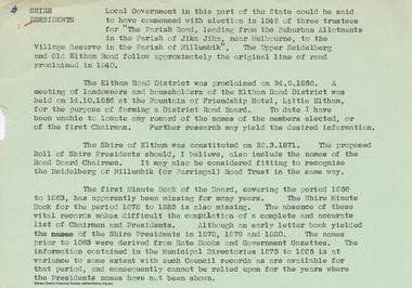
Appendix to Shire Secretary’s Report, 28 November 1966 SHIRE PRESIDENTS Local Government in this part of the State could be said to have commenced with election in 1846 of three trustees for "The Parish Road, leading from the Suburban Allotments in the Parish of Jika Jika, near Melbourne, to the Village Reserve in the Parish of Nillumbik". The Upper Heidelberg and Old Eltham Road follow approximately the original line of road proclaimed in 1840. The Eltham Road District was proclaimed on 24.9.1856. A meeting of landowners and householders of the Eltham Road District was held on 14.10.1856 at the Fountain of Friendship Hotel, Little Eltham, for the purpose of forming a District Road Board. To date I have been unable to locate any record of the names of the members elected, or of the first Chairman. Further research may yield the desired information. The Shire of Eltham was constituted on 28.3.1871. The proposed Roll of Shire Presidents should, I believe, also include the Road Board Chairmen. It may also be considered fitting to recognise the Heidelberg or Nillumbik (or Warringal) Road Trust in the same way. The first Minute Book of the Board, covering the period 1856 to 1863, has apparently been missing for many years. The Shire Minute Book for the period 1878 to 1885 is also missing. The absence of these vital records makes difficult the compilation of a complete and accurate list of Chairmen and Presidents. Although an early letter book yielded the names of the Shire Presidents in 1878, 1879 and 1800. The names prior to 1863 were derived from Rate Books and Government Gazettes. The information contained in the Municipal Directories 1875 to 1885 is at variance to some extent with such Council records as are available for that period, and consequently cannot be relied upon for the years where the Presidents names have not been shown. shire of eltham archives, series listing, a. armstrong, a. beale, a. brinkkotter, a. donaldson, a.h. price, a.j. braid, c.h. bath, c.m.a. pelling (mrs.), c.t. bell, d.c. o'beirne, e.d. butler, e.h. cameron, e.j. andrew, e.p. harmer, f.e. griffith, f.v. squire, f.w. nankervis, g. love, g. robertson, h. dendy, h. hewitt, h. stooke, l.t. wilmot, j. cox, j. murray, j. barr, j. bell, j. fitch, j. herbert, j. lawrey, j. mealy, j. pape, j. ryan, j. smedley, j.b. shallard, j.l. beale, l. c. docksey, r. mcadam, r.a. bell, r.c. white, r.r. woolcott, rutter, s.s. addison, s.w. scott, t. armstrong, t. irvine, w. horris, w. hubbard, w. lorimer, w. morris, w. taylor, w.c. farrell, w.f. ford, w.g. gray, w.h. bradbury, w.j. taylor, w.v. houghton -
Federation University Historical Collection
Book - Various Committee minute book, Ballarat School of Mines and Industries, Ballarat, Ballarat School of Mines Equipment committee, Student loan fund committee, Legislation/constitution committee and appeal committee minutes, 13/03/2021
School of Mines is a predecessor of Federation UniversityThese minute books record the meetings of several different committees, including Equipment committee, student loan fund committee, legislation and constitution committee and appeal committee, of School of Mines in the 1970's and give us an understanding of the operations of the School of Mines in that era and of the people involved with the institution at that time. It shows projects that were being undertaken at the institution at the time and gives us an historical perspective on project costs and the type of work being done.Large red book with gold lettering on the front and hand writing on the spine in black marker.Sticker on front cover listing committees and writing on the spine.ballarat school of mines, appeal committee, equipment committee, legislation and constitution committee, student loan fund committee, w.j.c north, e.j tippett, w.j. anderson, a.e stohr, m.b john, k.h price, j.j smail, l.c yandell, h. patterson, g.k sutton, william d jenkins, maxwell lazarus, neil. a matthews, anthony m. smith, peter. j smith, neil. a pinniger, peter. j white, christopher. f bones, dannt livitsanos, ronald f. mason, david. j douglas, philip. a findlay, kevin. j mcilvena, bruce. e greening, j.a sharrock -
 Federation University Historical Collection
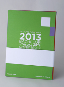
Article - Catalogue pack, Graduate Publication 2013 Bachelor of Visual Arts Graphic Design & Multimedia, 2013
University of Ballarat, third year / graduate A5 promotional pack/publication consisting of four volumes and one 4pp card, with a paper wrap holding the five pieces together. Reverse of Volume Two lists lecturers: Chrissie Smith, Ben Mangan, Glen Bellman, Gavin Nash, Luke Keys, Damian Lentini and Jennifer Jones-O'Neill Guest speakers at the event were Travis Price, Amy Walker, Sam Harmer, Nick Hallem and Phillip Berry. Publication layout and design attributed to Leah Armstrong, Josh Dunbar and Carleen Harmon. Poster, Invitation and flyer design attributed to Leah Armstrong, Josh Dunbar, Carleen Harmon and Lara Russell. Sovereign Press sponsored the print. Exhibition opening Friday 22 November 2013. Students listed across volumes are: V1: Scott Gullock, Carleen Harmon, Kate Simpson, Josh Dunbar, Jennifer Marlow. V2: Billy Burns, Jessica Nuzum, Leah Armstrong, Lisa Kearney, Samantha Reddie, Lauren McKenna. V3. Ashlea Caygill, Sarah Trotter, Naomi Roberts, Simon Dunbar, Lara Russell, Ray Edwards, Casey Pinkerton. V4: Teghan Johns, Tyler Zebra, Nawal Al-Adasani, Bonnie Redfern, Amarinda Long, Dylan Leak. University of Ballarat, third year / graduate A5 promotional pack/publication consisting of four volumes and one 4pp card, with a paper wrap holding the five pieces together.teghan johns, tyler zebra, nawal al-adasani, bonnie redfern, amarinda long, dylan leak., ashlea caygill, sarah trotter, naomi roberts, simon dunbar, lara russell, ray edwards, casey pinkerton., billy burns, jessica nuzum, leah armstrong, lisa kearney, samantha reddie, lauren mckenna, scott gullock, carleen harmon, kate simpson, josh dunbar, jennifer marlow, university of ballarat, federation university, graphic design, multimedia, bachelor, degree, camp street campus, arts academy -
 Federation University Historical Collection
Book - Catalogue, Hype – GD/MM – Federation University Australia 2015, 2015
The Hype 'zine (magazine" accompanied a projection project of the same title, projected onto the Ballarat Town Hall, Sturt Street, every night between 1 and 11 October 2015. Student names: Callum Bennier, Renee Bevan, Maddie Durie, Ben Hall, Callum Jenkins, Shannon Johnstone, Mel Negri, Brad O'Loughlin, Jess Powell, Jake Richardson, Chenae Smith, James Stuart, Elaine Tso, Laura Wright. Acknowledgments on final page. Lecturers and supporters: Alistair Heighway, Ben Mangan, Chrissie Smith, Debbie Hill, Travis Price, Jennifer Jones-O'Neil, Jill Orr, Jimmy Pasakos, John McDonald, Justin Weyers, Luke Keys, Paul Mah, Peter Gaulke, Peter Pilven, Phillip Berry, Roberta Crisci-Richardson. "A further thank you to the guidance and contribution to our final year: Ben Mangan, Peter Gaulke, Phillip Berry." Sponsors listed on final page and inside back cover.Promotional catalogue created by Federation University, Bachelor of Visual Arts (Graphic Design / Multimedia) third year, graduating students, 2015. 36pp full colour text pages and 4pp saddle-stitched cover, Uncoated stock. Cover of this version includes three unprinted circular stickers, and two printed stickers (one silver featuring word "wow?" and a fluorescent orange saying "real fake").university of ballarat, federation university, graphic design, multimedia, bachelor, degree, camp street campus, arts academy, callum bennier, renee bevan, maddie durie, ben hall, callum jenkins, shannon johnstone, mel negri, brad o'loughlin, jess powell, jake richardson, chenae smith, james stuart, elaine tso, laura wright., alistair heighway, ben mangan, chrissie smith, debbie hill, travis price, jennifer jones-o'neil, jill orr, jimmy pasakos, john mcdonald, justin weyers, luke keys, paul mah, peter gaulke, peter pilven, phillip berry, roberta crisci-richardson. -
 Federation University Historical Collection
Book - Catalogue, Disruption By Design: Intentional Catalyst for Change, 2012
This publication accompanied the exhibition of UB Bachelor of Visual Arts (Graphic Design) graduate students which ran from 23 November to 2 December 2012. Foreword by Professor John McDonald, Dean, School of Education and Arts, and by "Inkahoots" design studio. Student list: Christopher Frith, James Croft, Jesse Mason, Andrew Cox, Daniel Roache, Jenna Locket, Aaron Croft, Emily Phillips, Caitlin Heimeier, Maddy Collicoat, Brayden Waight, Elisa Micallef, Danii Zecevic, Zoe-Lee Scriven, Carla Ellis, Bryce Holywell, Lindsay Sewart, Megan Sutherland, Steven Fiume, Brianna Wines, Matt Sullivan, Alyssa Roberts, Hayley Burman, Jacqui Leutenmayr, Jessica Weston, Kimberley Wilson, Georgia Clarke, Josh Fry, Breanna Dignan, Lucy-Ann Moore, Tom Miatke, Daniel Howard, Matt Watts. 33 students. Inside back cover, thanks supporters, lecturers and sponsors. Lecturers: Ben Mangan, Chrissie Smith, Gavin Nash, Luke Keys, Glen Bellman, Travis Price, Sam Harmer, Damian Lentini, Jennifer Jones-O'Neill, Jimmy Pasakos, Pete Swan and Peter Pilven. Book layout and design by Aaron Croft, James Croft and Daniel Howard. Note: "Multimedia" has been removed from the degree title here.Promotional catalogue created by University of Ballarat, Bachelor of Visual Arts (Graphic Design) third year, graduating students, 2012. 40pp text pages (printed orange, silver and black) and 4pp saddle stitched cover (printed orange and silver), uncoated stock.university of ballarat, federation university, graphic design, multimedia, bachelor, degree, camp street campus, arts academy, christopher frith, james croft, jesse mason, andrew cox, daniel roache, jenna locket, aaron croft, emily phillips, caitlin heimeier, maddy collicoat, brayden waight, elisa micallef, danii zecevic, zoe-lee scriven, carla ellis, bryce holywell, lindsay sewart, megan sutherland, steven fiume, brianna wines, matt sullivan, alyssa roberts, hayley burman, jacqui leutenmayr, jessica weston, kimberley wilson, georgia clarke, josh fry, breanna dignan, lucy-ann moore, tom miatke, daniel howard, matt watts, ben mangan, chrissie smith, gavin nash, luke keys, glen bellman, travis price, sam harmer, damian lentini, jennifer jones-o'neill, jimmy pasakos, pete swan and peter pilven -
 Federation University Historical Collection
Booklet - Catalogue, Once upon a time… The Land of Design, Advanced Diploma of Arts (Graphic Design), 2008, 2008
Storybook/fairytale themed promotion of student work on completion of the two-year Advanced Diploma of Arts (Graphic Design) course at University of Ballarat, 2008. Page one features student names and photographs, plus "character" names. Pages 2-3 fairytale map. Subsequent pages include folio examples, one student per double page spread. Inside back cover notes sponsors, Sovereign Press and The Image Company. Teaching staff for duration of the two-year course listed as: James Baker, Peter Lambert, Jill Hyatt, Ben Sanders, Travis Price, Sam Harmer, Trevor Tagliabue, Alister Heighway, Sarah Lloyd. Promotional catalogue for graduating students of the University of Ballarat (TAFE), Advanced Diploma of Arts (Graphic Design). 32-page + 4-page cover saddle-stitched booklet. Full colour offset throughout.university of ballarat, federation university, graphic design, tafe, advanced diploma, arts academy, camp street campus -
 Federation University Historical Collection
Article - Catalogue package, Creativity Released, Advanced Diploma of Graphic Design, 2010, 2010
Unprinted, forme-cut black folder, triangular window, sealed with triangular sticker containing a suite of A5 (148 x 210mm) cards promoting works of University of Ballarat, Advanced Diploma of Graphic Design (2 years) students. Contains 15, two-sided A5 cards, most featuring student work. Reverse of first card lists 12 graduates for 2010. Introduction by Paul Mah (co-ordinator / teacher). Teaching staff listed as Sam Harmer, Jill Hyatt, Slena Shillito, Travis Price, Ben Sanders, Anthony Woodward, Paul Mah, Alister Heighway, Peter Lambert, James Baker. Printed by Sovereign Press. Pack by Bennet-Meyer Packaging. One card features supporting sponsors Unprinted, forme-cut black folder, triangular window, sealed with triangular sticker containing a 15 A5 cards promoting student work.Promotional catalogue (pack of A5 cards) for graduating students of the University of Ballarat (TAFE), Advanced Diploma of Graphic Design. Unprinted, forme-cut black folder, triangular window, sealed with triangular sticker containing a 15 A5 cards promoting student work.university of ballarat, federation university, graphic design, tafe, advanced diploma, arts academy, camp street campus -
Federation University Historical Collection
Article - Catalogue package, Creativity Released, Advanced Diploma of Graphic Design, 2010, 2010
Unprinted, forme-cut black folder, triangular window, sealed with triangular sticker containing a suite of A5 (148 x 210mm) cards promoting works of University of Ballarat, Advanced Diploma of Graphic Design (2 years) students. Contains 15, two-sided A5 cards, most featuring student work. Reverse of first card lists 12 graduates for 2010. Introduction by Paul Mah (co-ordinator / teacher). Teaching staff listed as Sam Harmer, Jill Hyatt, Slena Shillito, Travis Price, Ben Sanders, Anthony Woodward, Paul Mah, Alister Heighway, Peter Lambert, James Baker. Printed by Sovereign Press. Pack by Bennet-Meyer Packaging. One card features supporting sponsors Unprinted, forme-cut black folder, triangular window, sealed with triangular sticker containing a 15 A5 cards promoting student work.As per parent record, but opened. Promotional catalogue (pack of A5 cards) for graduating students of the University of Ballarat (TAFE), Advanced Diploma of Graphic Design. Unprinted, forme-cut black folder, triangular window, sealed with triangular sticker containing a 15 A5 cards promoting student work.university of ballarat, federation university, graphic design, tafe, advanced diploma, arts academy, camp street campus -
 Federation University Historical Collection
Book - Catalogue, ADGD, Advanced Diploma of Graphic Design, Graduate Book, 2011, 2011
Page 4 features list of 13 graduates of the University of Ballarat Advanced Diploma of Graphic Design (2 years). Introduction by Paul Mah (co-ordinator / teacher). Teaching staff listed: Sam Harmer, James Baker, Selena Shillito, Travis Price, Jill Hyatt, Ben Sanders, Anthony Woodward, Alister Heighway, Peter Lambert, Paul Mah. Cover design by Kylie Findlay (student). Student work featured throughout along with student names, photos and contact details. 32pp + 4pp cover saddle-stitched booklet. Full colour cover, gloss varnish pattern, gold foil. Full colour offset pages. Promotional catalogue for graduating students of the University of Ballarat (TAFE), Advanced Diploma of Graphic Design, 2011. 32-page + 4-page cover saddle-stitched booklet. Full colour cover, gloss varnish pattern, gold foil. Full colour offset pages.university of ballarat, federation university, graphic design, tafe, advanced diploma, arts academy, camp street campus -
4th/19th Prince of Wales's Light Horse Regiment Unit History Room
Booklet, Priced List of Equipment, 1939
... covered 16 page booklet giving prices of Army equipment Priced ...Notified in A.A.Os dated 31 October 1939Soft covered 16 page booklet giving prices of Army equipment -
 Flagstaff Hill Maritime Museum and Village
Tool - Wood moulding Plane, Edward Preston & Sons, Early 20th century
By the end of the nineteenth century, the firm of Edward Preston & Sons was founded in 1825, becoming one of England's leading makers of hand tools and in many ways a British counterpart to America's "Stanley" for its wide range of quality utilitarian tools at affordable prices. Edward Preston Sr. (1798–1883) was first listed as a plane-maker at 77 Lichfield Street in the Birmingham Directory of 1833, but later listings and advertisements assert that the business was started in 1825. Preston is likewise recorded as a plane-maker living with his family in Lichfield Street in the 1841 census, at which time his younger son Edward was 6 years old. Around 1850, his son Edward left school to join his father's business and is recorded in the 1851 census as a plane-maker at his father's address. He appears to have been quite a talented and resourceful young man, as he had later been able to start up his own "wood and brass spirit level manufacturing business at 97½ Lichfield Street by 1864. By 1866, Edward Jnr had added planes, routers, joiners, coach, gun, cabinet, and carpenters tools to his line, and the following year he moved his shop from his father's address and relocated to 26 Newton Street, before moving again to much larger premises at 22–24 Whittall Street. This location became known as the Whittall Works and later was the office and factory of Edward Preston & Sons, Ltd. In 1889 Edward Preston Jnr and his three sons were brought into the firm and the name was changed to Edward Preston & Sons, becoming Edward Preston & Sons Ltd on incorporation in 1898. Part of the firm's output was a healthy line of malleable and gun-metal planes and patent adjustable iron smoothers, shoulder planes, bull-nose, and block planes - a range that was expanded in later years. The 1901 catalog shows several styles of planes that were unique to the Preston brand, along with the usual styles which had already been set by other makers. The death of Edward Preston Jnr was reported in the Lichfield Mercury of 26 September 1913. "Mr. Preston was decided of an innovative turn of mind," the newspaper wrote, "as many of the machines in use at his works, as well as of the tools produced were the invention of himself and his three sons, who now manage the business." The report noted that at the time of his death, the business was carried on at Whittall Works, Cheston Street, Aston, Birmingham. Falling on hard times, the firm of Edward Preston & Sons was sold to the Birmingham firm of John Rabone & Sons in 1932, and shortly thereafter manufacturing rights to some of the Preston range of planes were sold to the Sheffield firm of C. & J. Hampton, who would later merge with the Record Tool Company. Some of the Preston planes were directly added to the Record line by the Hampton firm, while others were modified or discontinued altogether. Generally, all Preston wooden planes are stamped on the front of the plane, the shape, size, and character type of the stamp indicating the age of the plane. On some metal planes, all the parts were stamped with a number or symbol during manufacture. This number was used to re-assemble the parts following a batch process. Not all Preston tools are trade-marked clearly. Early shoulder, rebate, chariot planes, and chamfer rebates commonly appear without trademarks but may have assembly numbers. The "E P" trade-mark was already in use by 1882. The trade-mark "Preston" also appears on some later tools that were manufactured in Sheffield, England. These are generally smoothing planes and appear modern and very similar in construction to other modern manufacturers' planes.The item gives a snapshot of one of England's premier tool manufacturing companies at a time when significant industrial changes were occurring in manufacturing and business structures in the World that were beginning to affect social changes.Ogee wood moulding plane Maker E Preston & Sons No 5 (Owner A T Nipe) also has A's stamped on ends and the No 7flagstaff hill, warrnambool, shipwrecked-coast, flagstaff-hill, flagstaff-hill-maritime-museum, maritime-museum, shipwreck-coast, flagstaff-hill-maritime-village -
Glenelg Shire Council Cultural Collection
Booklet - Cinema Program, 'Observer' Print Portland, Star Cinema Program, 1935
... ' for weeks ending January 26 and February 2, 1935. Includes list.... Includes list of films, admission prices, where to buy tickets ...The Star Theatre opened on 7th November 1925, with 991 seats located in orchestra and balcony levels. It was rebuilt to the plans of architect Geoffrey S. Richards, opening of 27th October 1937. In 2011, there was a small Star Cinema operating in the former balcony area. The main orchestra floor has been in use as a plumbers merchants, but is unused. The Star Cinema was closed in 2015 and is now in use as a church.Green card (folded) Cinema Program for 'Star Talkies' for weeks ending January 26 and February 2, 1935. Includes list of films, admission prices, where to buy tickets and whether the films are suitable or not suitable for a general audience.star cinema -
Glenelg Shire Council Cultural Collection
Administrative record - Administrative record - Proposed Heritage Valley Subdivision, 15/04/1992
Two lined sheets of paper, Elder's Real Estate logo top left, photocopies. Contain lists of lot numbers, area and price of blocks in proposed Heritage Valley subdivision. a) is an updated list and b) a further updated list -
 City of Moorabbin Historical Society (Operating the Box Cottage Museum)
Manufactured objects, safety matches Bryant & May Ltd, 20thC
Bryant and May was a United Kingdom (UK) company created in the mid-nineteenth century specifically to make matches. Their original Bryant and May Factory was located in Bow, London. They later opened other match factories in the United Kingdom and Australia, such as the Bryant and May Factory, Melbourne; and owned match factories in other parts of the world.Bryant and May survived as an independent company for over seventy years, but went through a series of mergers with other match companies and later with consumer products companies. To protect its position Bryant and May merged with or took over its rivals. In 1971 the Northern Ireland factory, Maguire & Patterson closed down following a terrorist attack.. In the 1980s, factories in Gloucester and Glasgow closed too leaving Liverpool as the last match factory in the UK, until December 1994. The former Australian match factory, in Melbourne, closed in the mid-1980s. The registered trade name Bryant and May still exists and it is owned by Swedish Match, as are many of the other registered trade names of the other, formerly independent, companies within the Bryant and May group. The British match brands continue to survive, as brands of Swedish Match, and are made outside the UK. Matches were first produced by Bryant & May in Australia in 1909. The Redhead name applies to the red striking heads of the matches which were introduced to Australia in 1946. The logo on the matchbox depicted the head and shoulder of a redheaded woman and has had four major updates since that time with a number of special issues depicting animals, birds and notable persons also producedThe Bryant & May Ltd factory in Church St Richmond is a listed building and has been converted to apartments following the closure of the Company 1980. Bryant & May's Ltd were influential in fighting against the dreadful disease known as Phossy jaw which was caused by white phosphorus used in the manufacture of the early matches. They were also the object of the 'Match Girls Strike' in London 1888, which won important improvements in working conditions and pay for the mostly female workforce working with the dangerous white phosphorus. The public were slow to purchase these safety matches because of the higher price .A box of safety matches with unused matches made by Bryant & May Pty Ltd , Richmond Victoria Australia. The tray containing the matches slides inside the open ended cover.. The striking patch is on both sides of the cover.PREVENT FIRES/ BRYANT & MAY'S / a crown in an oval shape / SAFETY MATCHES/ MOTORISTS USE ASHTRAY/ AV. CONTENTS 60 / Made in Australiasafety matches, bryant & may's pty ltd, phosy jaw disease, early settlers, moorabbin, bentleigh, richmond, cheltenham, lights, lamps, tobacco -
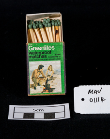 City of Moorabbin Historical Society (Operating the Box Cottage Museum)
Maufactured Objects, 1 box of Bryant & May waterproof safety matches, 20thC
‘Strike anywhere’ or ‘Waterproof’ matches are still used today all around the world, including many developing countries and are widely used for camping, outdoor activities, emergency/survival /military situations, and stocking homemade survival kits. Anton Schrötter von Kristelli discovered in 1850 that heating white phosphorus at 250 °C in an inert atmosphere produced a red allotropic form, which did not fume in contact with air. It was suggested that this would make a suitable substitute in match manufacture although it was slightly more expensive. Two French chemists, Henri Savene and Emile David Cahen, proved in 1898 that the addition of phosphorus sesquisulfide meant that the substance was not poisonous, that it could be used in a "strike-anywhere" match, and that the match heads were not explosive. British company Albright and Wilson, was the first company to produce phosphorus sesquisulfide matches commercially. The company developed a safe means of making commercial quantities of phosphorus sesquisulfide in 1899 and started selling it to match manufacturers. Bryant and May was a United Kingdom (UK) company created in the mid-nineteenth century specifically to make matches. Their original Bryant and May Factory was located in Bow, London. They later opened other match factories in the United Kingdom and Australia. On 15th December 1909, Bryant & May, Australia’s first match factory at Church Street, Richmond, Victoria. was opened by The Honorable Alfred Deakin, Prime Minister of Australia, and Mrs. Deakin The Bryant & May Ltd factory in Church St Richmond is a listed building and has been converted to apartments following the closure of the Company 1980. Bryant & May's Ltd were influential in fighting against the dreadful disease known as Phossy jaw which was caused by white phosphorus used in the manufacture of the early matches. They were also the object of the 'Match Girls Strike' in London 1888, which won important improvements in working conditions and pay for the mostly female workforce working with the dangerous white phosphorus. The public were slow to purchase these red phosphorus sesquisulfide safety matches because of the higher price1 box of unused Bryant & May safety matches 'Greenlite' waterproof Greenlites / waterproof / matches / CONTENTS 47 / MADE IN AUSTRALIA BY BRYANT & MAY / E 2994 photograph of a man and woman beside a camp fire on the beachsafety matches, bryant & may pty ltd, phossy jaw disease, early settlers, moorabbin, bentleigh, cheltenham, lights, lamps, tobacco, white phosphorous, red, phosphorus sesquisulfide, swedish match pty ltd, pitt william, savens henri, cahen emile david , richmond victoria, -
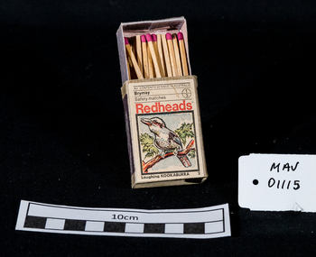 City of Moorabbin Historical Society (Operating the Box Cottage Museum)
Containers, matchbox 'Redhead' with matches, 20thC
On 15th December 1909, Bryant & May, Australia’s first match factory at Church Street, Richmond, Victoria. was opened by The Honourable Alfred Deakin, Prime Minister of Australia, and Mrs. Deakin. It was heralded by the first Commonwealth Government of newly-federated Australia because the government of the day was anxious to encourage secondary industry and pledged tariff protection of local manufacturers. The building was constructed in 1909 as the Empire Works to a design by prolific Melbourne architect William Pitt and was purchased soon after by British safety match manufacturer Bryant and May, who significantly expanded the building, adding another level and the landmark clock tower. Bryant and May were unique in that they operated as a model factory, providing workers with conditions and amenities that even today seem generous. These included a dining hall and sports facilities such as a tennis court and bowling green which were constructed in the 1920s. Bryant and May ceased Australian match manufacture in the early 1980s as a result of import competition. Their iconic Redheads matches are now imported from Sweden. The complex has since been converted for use as offices and showrooms but is extremely well preserved. It is listed on the Victorian Heritage Register. Bryant and May was a United Kingdom (UK) company created in the mid-nineteenth century specifically to make matches. Their original Bryant and May Factory was located in Bow, London. They later opened other match factories in the United Kingdom and Australia, such as the Bryant and May Factory, Melbourne; and owned match factories in other parts of the world. Bryant and May survived as an independent company for over seventy years, but went through a series of mergers with other match companies and later with consumer products companies. To protect its position Bryant and May merged with or took over its rivals. In 1971 the Northern Ireland factory, Maguire & Patterson closed down following a terrorist attack.. In the 1980s, factories in Gloucester and Glasgow closed too leaving Liverpool as the last match factory in the UK, until December 1994. . The registered trade name Bryant and May still exists and it is owned by Swedish Match, as are many of the other registered trade names of the other, formerly independent, companies within the Bryant and May group. Two French chemists, Henri Savene and Emile David Cahen, proved in 1898 that the addition of phosphorus sesquisulfide meant that the substance was not poisonous, that it could be used in a "strike-anywhere" match, and that the match heads were not explosive. British company Albright and Wilson, was the first company to produce phosphorus sesquisulfide ( Red Phosphorous) matches commercially. The company developed a safe means of making commercial quantities of phosphorus sesquisulfide in 1899 and started selling it to match manufacturers. Matches were first produced by Bryant & May in Australia in 1909. The Redhead name applies to the red striking heads of the matches which were introduced to Australia in 1946. The logo on the matchbox depicted the head and shoulder of a redheaded woman and has had four major updates since that time with a number of special issues depicting birds, animals and notable persons also produced.The Bryant & May Ltd factory in Church St Richmond is a listed building and has been converted to apartments following the closure of the Company 1980. Bryant & May's Ltd were influential in fighting against the dreadful disease known as Phossy jaw which was caused by white phosphorus used in the manufacture of the early matches. They were also the object of the 'Match Girls Strike' in London 1888, which won important improvements in working conditions and pay for the mostly female workforce working with the dangerous white phosphorus. The public were slow to purchase these safety matches because of the higher price .A box of safety matches with unused matches made by Bryant & May Pty Ltd , Richmond Victoria Australia. The tray containing the matches slides inside the open ended cover.. The striking patch is on both sides of the cover. Av. CONTENTS 50 MADE IN AUSTRALIA / Brymay / 1/3 / Safety Matches / Redheads / a colour picture of a Kookaburra / Laughing KOOKABURRAsafety matches, bryant & may pty ltd, phossy jaw disease, early settlers, moorabbin, bentleigh, cheltenham, lights, lamps, tobacco, white phosphorous, phosphorus sesquisulfide, swedish match pty ltd, pitt william, savens henri, cahen emile david , richmond victoria, -
 Kiewa Valley Historical Society
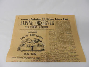
Newspaper Article - Tawonga School Centenary 1980 x2, Alpine Courier incorporating The Hydro Courier, 1980
This newspaper article was produced at a time when newspapers were the main source of local information. The period before the explosion of mobile communication technology and the cost effectiveness of communication by "texting" and internet "social connections, eg. facebook and other social media networkings" The newspapers were the main links between and within large regions. The Hydro Courier was first printed in 1950 as a YMCA community service publication by Mr. Albert Clarke YMCA Officer and Mr. Alex McCullough a State Electricity Commission employee. This paper was one very important publication that provided relevant community information to all and was the major contributer to the "Valley" cohesive fibre and unity. This article not only records the celebration (centenary) of the Tawonga School but also presents the history of the school and important events such as various relocations of classrooms and how the region was settled and developed from the 1870's onward. The yawonga school opened in 1880 on 8 acres of land. It consisted of one large wooden building (22 ft x 11 ft). It had two windows, one brick chimney, bare wooden floor and a shingle roof. This article also presents the time when Mount Beauty area was likened to an island and occasionally school children could not attend school because of a flooded Kiewa river. The article also covers the changes brought about by the increased employment opportunities from SEC Kiewa Works(1935), the Sawmill(1946), the Gold mine(1949) and the Tobacco Industry (largest growing area in Australia).This item is a one page (original) article of the centenary celebrations for Tawonga Primary School came from the Alpine Observer and incorporated the Hydro Courier. It covers the arrangements for the celebration of the 100 years of the school's existence. The printed layout is typical of the typeset in use in 1980's. There are seven distinctive type collumns separated by a printed line. Three photographs are published with one photograph of a demountable classromm ,circa 1980, and the other two of student class photos of 1899 and 1914. Teacher and student names are listed below each photograph. On the back of this page are "specials" for "Sam's Cut Price Stores", specifically the Myrtleford store. Of interest is the advertisement of "Cartons of Cigarettes at cut prices". The page was produced as part of a "run" with "telltale" holes at each corner for stabilising the page in the printing process."Centenary Celebrations For Tawonga Primary School" below this in an enclosed heading "ALPINE OBSERVER" underneath in smaller print "WITH WHICH IS INCORPORATED" below this in larger print "THE HYDRO COURIER" and below this from left to right, "No. 719 (Vol. 3) THURSDAY, 23rd OCTOBER, 1980" next "in smaller print Recommended Price Single Copy, 20c "(cents)rural school development, tawonga school centenary, kiewa valley development 1880 to 1980 -
 The Cyril Kett Optometry Museum
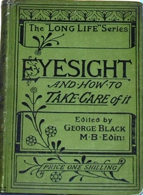
Book, Eyesight and how to take care of it, 1888 (estimated)
This book is a guide to eyecare for the intelligent lay-reader, not so different from books still published today. It appeared in a number of editions until about 1900. This one is edited by George Black MB(Edin) as part of the Long Life Series. As this book is a guide to eyecare for the lay-reader it is socially significant. It is not rare, but being somewhat ephemeral it would not be expected to see copies of this book surviving in the very good condition of our copy. No other copies are listed on WorlCat for Australia.Small hardback book in original printed green cloth covers, 139 pages and 21 figures with 20 pages of book advertisements. The decorative Art Nouveau cover is visually attractive. It is a late nineteenth century guide to eyecare for the intelligent lay-reader. It was priced at one shilling.Signature of J B Shattock on half title page.ophthalmology, eye, eyesight, eyecare -
 Ringwood and District Historical Society
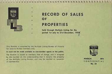
Booklet, Record of Sales of Properties in Victoria 1973-1979 (missing 1977)
Multiple listing Bureau of Victoria compiled the booklets. Carter Real Estate Agents were members of the multiple listing bureau and were issued with the booklets11 spiral bound booklets with covers of various colours of buff and green. Containing addresses, number of rooms, age, selling agents and the price of houses in Melbourne. Country areas included - Geelong, Ballarat, Bendigo Mornington and South Western."RECORD OF SALES OF PROPERTIES ... This Booklet is compiled by the Multiple Listing Bureau of Victoria for issue to Bureau members only. It must not be made available to non-member agents or the public." -
 Cheese World Museum
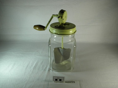
Butter Churn, Taco butter churn, 1880 (estimated)
These glass churns came in several different sizes. A 3 and 1/2 pint vessel could churn 2 pints of cream into butter. A similar glass churn is advertised in the mail order catalogue for D & W Chandler Ltd, Melbourne. Issue No.49, page 168. Listed as 'Butter machines (Glass) Makes butter equal to the best wooden churn, and quicker. Prices-2 qts, 9/6; 3 quts, 13/3; 4 qts, 14/6 each.'Taco butter churn with square clear glass jar with round mouth and round green painted metal lid with a small wedge of airholes. The lid has a round turning mechanism with attached wooden handle. A shaft with a metal paddle goes down into the jar to beat the cream. A paper label is attached to the bottom.'Taco Burnley England' on turning mechanism on lid, 'British Foreign Pats Pending' on reverse. 'Made in England' imprinted on base. Paper label attached to base 'Kraft Foods Ltd' 'M.G.'butter, allansford, dairy industry, dairy utensils, butter churns, kraft foods ltd, taco -
 Cheese World Museum
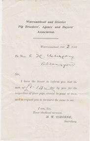
Licence, Pig Breeders Licence, 1903
The Uebergang family came from Silesia to Australia in 1848 and were early settlers in the Allansford area. The sons and other descendants also purchased farms in the area. The Percy Uebergang family lived at Tooram Park, Allansford from 1912 until 1992. Percy and Myrtle Uebergang's children were twins, Ray and Joyce born in 1926 who lived at Tooram Park until their deaths, Ray in 1986 and Joyce in 1992 after which the property was sold. Neither Ray nor Joyce married and following the death of her brother Joyce set up the Ray and Joyce Uebergang Foundation which supports the local community. The collection of items from their property was put into store for a number of years before being given into the care of the Cheese World Museum. The family often re-used, recycled and repaired items and examples can be seen in the museum. This item is part of the collection of items given into the care of the Cheese World Museum. The Warrnambool and District Pig Breeders', Agents and Buyers' Association was responsible for inspecting pigs. During the early 20th century the pig industry was included as part of the dairy industry. After milk was separated the cream went to the factory and the skim milk went back to the farm to feed the pigs. Early newspaper reports include information relating to the price of bacon in the list of dairy goods. Warrnambool Cheese and Butter Factory commenced a bacon factory in the early 1900s but it was a short-lived operation. This licence is significant as it assists in understanding the relationship between the dairy industry and the pig industry.A5 size paper with black printed details of the Warrnambool and District Pig Breeders', Agents' and Buyers' Association with the date of the licence, name of licensee and fee due.Warrnambool and District/Pig Breeders', Agents' and Buyers'/Association/Warrnambool, Oct 2 1903/To Mr C H Uebergang/Allansford/Sir,/I have the honor to inform you that the sum of £1-14 due by you for the inspection of your pigs, should be paid at once, and to request you to forward the same to me./I am, Sir,/Your obedient servant,/H.W. OSBORNE,/Secretary [on reverse in pencil] M Millard £20.16.0allansford, uebergang, pigs, pig breeders, dairy industry, agriculture, warrnambool and district pig breeders -
 Learmonth and District Historical Society Inc.
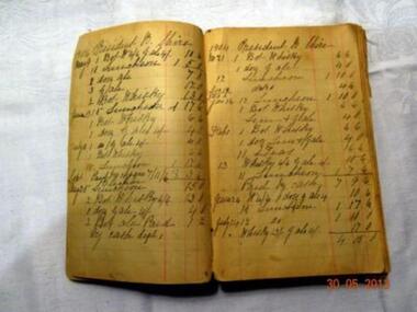
Book, Inventary of Liquer bought by Shire President, Late 19th Century
This book was kept as an inventory, by the Shire President. Cr Matthew John Ryan of all liquor bought,and shows the date, particular liquor and cost.Record of money spent.Small Inventary book documenting Liquer boughtList of various Liquers bought ,with dates and prices.liquer register.councilor mathew john ryan.c 1904