Showing 844 items
matching surveyors
-
 Bendigo Historical Society Inc.
Document - UNDERGROUND SURVEY OF BENDIGO MINES
Two page document, 'Underground survey of Bendigo, report on Constellation Company's Mine on northern extension of the Garden Gully line of reef. Report on the New Chum Railway Reserve Company and the Shenandoah Company, the New Chum Railway Co being immediately south and the Shenandoah Co immediately north of the railway line. Two maps Constellation Co. Mine shaft and New Chum Railway and Shenandoah auriferous reef below 2700 feet.Jems Stirling, geologist and W.H Cundy Underground Surveyor, Department of Minesbendigo, mining, garden gully line of reef mines -
 Ringwood and District Historical Society
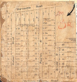
Map, Residential Subdivision Allotment Layout on Mullum Mullum Road, Hobart Street, Paxton Street, Arnold Street and Warrandyte Road, Ringwood, Vic. circa 1920
One of 3 unrelated land subdivision maps on cardboard backing.H.C. Crouch, Licensed Surveyor, 443 Lt Collins Street, Melbourne. -
 Ringwood and District Historical Society
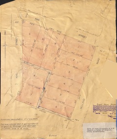
Document - Plan of Subdivision, Parts of Crown Allotments 45 & 46, Township & Parish of Ringwood, County of Mornington - 1950
Map on manila folder attached to cardboard backing showing residential allotments on King Street and Holland Road, Ringwood East.Signature of Russell Francis Kinnane, Licensed Surveyor, 4th December, 1950. -
 Ringwood and District Historical Society
Article - Newspaper Clipping, Land Sale Advertisements, Golden Hill Estate, Ringwood - 1965, 1966, and Plan of Survey of Lot 8, Mullum Mullum Road Ringwood, 1970
Newspaper clippings from Melbourne Sun newspaper (11th December 1965 and 15th January 1966) advertising sale of land - Golden Hill Estate, Ringwood, with summary of features and aerial photograph including artistic representation of street layout. Subdivision includes Mullum Mullum Road, Sonia Street, Jill Court, Linda Drive, Eve Court, Alma Court, and Jacynthe Court. Attachments include reference to Lot 46 as site of original Peter Vergers' orchard residence and subsequent 1970 surveyor's Plan of Survey of Lot 8 Mullum Mullum Road Ringwood, LP 67513, Cert of Title 8581/429.Agent - Aaron, King & Co., Suite 2, 33 Queens Road, Melbourne. (Phone) 26-2443, A.H. 850-2195. Plan of Survey signed on 25.7.1970 by Roger M. Gamble, Land Surveyor, 28 Summit Crescent, Ringwood 3134. -
 Warrnambool and District Historical Society Inc.
Letter book 14, 1923
This letter book contains letters, sketch maps and plans and dates from 1923 to 1926. It came from the office of John William Crawley, Junior, an engineer, surveyor and architect in private practice in Warrnambool and also the engineer for the Shire of Warrnambool from 1895 to 1935. His father, brother and son were also engineers, working in that capacity or as the Shire Secretary for the Shire of Warrnambool, with the Crawley family recording a total of 132 years of service to the Shire. The Shire of Warrnambool existed from 1863 to 1994. This letter book was passed on to John Crawley’s son, Rolf, the engineer for the Shire of Warrnambool from 1935 to 1968. It then came into the possession of Michael Hand who took over the private surveying business of Rolf Crawley in Warrnambool. The Warrnambool and District Historical Society acquired the letter book, along with several other Crawley ledgers, from the estate of Michael Hand.This letter book is of considerable significance as it contains letters, maps and plans drawn up by John William Crawley, an engineer and surveyor in private practice in Warrnambool and the engineer for the Shire of Warrnambool for 40 years. It will be useful for researchers. This is a brown hard cover letter book of 1010 pages, with brown binding on the corners of the cover and on the spine. The cover is cuffed and torn. There is gold lettering on the spine. The book contains handwritten letters, maps and plans and an alphabetical index at the front, The pages are water-stained. There is a mauve stamp on the first page.‘Letter Book 1923 to 1926’ ‘J. Wm. Crawley Shire Hall Warrnambool (Private)’ ‘Rolf L. Crawley Civil Engineer, Drainage and Water Supply Engineer, Licensed Surveyor, Registered Architect, Warrnambool’ john william crawley junior, warrnambool, rolf crawley, warrnambool, shire of warrnambool -
 Melbourne Tram Museum
Domestic object - Biography, Robert Green, H. S. McComb Collection, Goodbye Mr McComb, c2014
1 - list - Box Listing (box 73.1 to 73.13) prepared by Robert Green of the papers acquired from Howard McComb and donated to the depot. 2 - Biography of Howard Spencer McComb - MMTB Surveyor and historian from "The Victorian Historical Journal Vol 64, No. 1, April 1993" MMTB surveyor 1922 to 1962. Written by Warren Perry.trams, tramways, mmtb, surveys, history -
 Forests Commission Retired Personnel Association (FCRPA)
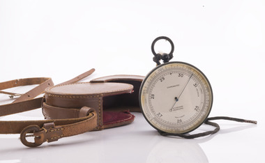
Surveyor's Pocket Altimeter, c 1940
This instrument measures elevation by sensing minute changes in barometric air pressure relative to a fixed datum point at sea level or a known elevation, such as the starting point of a major town during a road survey, and has an accuracy of +/- 20 feet when used in experienced hands. The finely divided scale around the perimeter of the face is marked from 0 to 6000 feet elevation and 25 to 31 inches of mercury (Hg) for barometric pressure The single fine counter-balanced hand or pointer rotates anti-clockwise with increasing elevation and decreasing pressure. The label "compensated" indicates that the instrument is constructed to compensate for the effect of temperature changes on the accuracy of readings. Surveyor's Pocket Altimeter - Aneroid Barometer Type Branded N H Seward, Melbourne. Made in England. With leather carrying case and strap.forest measurement, forests commission victoria (fcv), surveying -
 Bendigo Historical Society Inc.
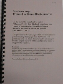
Book - SANDHURST MAPS, 1870s
Sandhurst Maps Prepared by George Black Surveyor. Enlarged from original survey Field Book. Prepared by Carol Holsworth December 2011george black, sandhurst maps, 1870 -
 Falls Creek Historical Society
Photograph - Mt McKay, Bogong High Plains
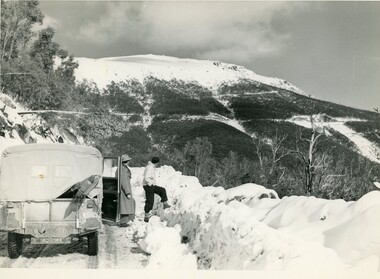
MEYER COLLECTION - FALLS CREEK PHOTOS In 1947 a determined group of like-minded State Electricity Commission (SEC) staff including Ray Meyer, the chief surveyor of the Kiewa Hydro-Electric Scheme, had a common interest that revolved around the skiing potential of the snow-covered high plains which included what is now the resort of Falls Creek. The six SEC employees, Toni St Elmo, Ray Meyer, Jack Minogue, Lloyd Dunn, Adrian Ruffenacht and Dave Gibson (together with their families) banded together to secretly build a 'hut' that was the first ski lodge at Falls Creek. Using a road built in 1930s to gain access to Falls Creek, their hut project was carried out in secret as efforts by other skiers were blocked by H.H.C. Williams – the engineer in charge of the Hydro Scheme. In 1946 Ray Meyer made a trip to the Lands Office in Melbourne. He came away with a 99-year lease on three acres that was ideally suited for a hut designed by Lloyd Dunn. Adrian Ruffenacht (Design Engineer for the KHS) had suggested where the group should build because of easy access to a spring for water. Much of the building material required was scavenged from derelict huts on the high plains. Due to the need for secrecy, the determined group worked on the hut in the evenings and weekends to avoid detection. During the building period the group had met at Echidna Rock (now known as Eagle Rock) where Skippy St Elmo announced, "This is my favourite ‘Skyline’.” And so the first lodge in the area at Falls Creek Ski Resort came into existence. With the development of the International Poma in the 1970s, the Skyline Lodge, which was sited between the ski-lift’s pole one and pole two, was demolished. However, the legacy of Ray Meyer, Toni St Elmo, Jack Minogue, Lloyd Dunn, Adrian Ruffenacht and Dave Gibson and Skyline lives on in the vibrant atmosphere of Falls Creek Resort. The MEYER COLLECTION documents developments on the Kiewa Hydro Scheme and their life at Falls Creek from the mid 1930s to 1960s.This image is significant because it depicts activities in the life of a pioneering family of Falls Creek area.A black and white photo of Phil Gabillot and Ray Meyer looking towards Mt. McKay and the High Plains. Phil Gabillot was in charge of "Trois Es', the French tunnel construction company and Ray Meyer was Chief Surveyor of the Kiewa Scheme at this time.falls creek, victorian snowfields, mt kckay, bogong high plains, ray meyer, phil gabillot -
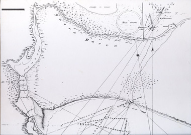
 Bendigo Historical Society Inc.
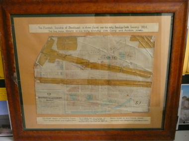
Document - PLAN OF TOWNSHIP OF SANDHURST 1854, July 25. 1854
Coloured- The planned township of Sandhurst is placed over the early Bendigo creek township of 1854. The two main streets of the early township were Camp and Auction streets. The street shown as Dowling street later became Queen & Hopetoun streets. The building near the bridge at View Point is Pykes Building. The Post Office was located here in 1854 - 58. Bernal street is now Chapel street. The creeks were straightened to their present courses. Streets on map are. Pall Mall - Bridge - McCrae - Hargraves - Lyttleton - Myers - Mollison - McLaren - Mitchell - Williamson - Mundy - Bernal - Baxter - Larritt - Bramble - McIvor - Bull. Also shown on map: Bendigo Creek - Government Reserve - Present Cemetery - Proposed diversion of creek. FH 562 Deframed 2022Lithographed at Surveyor Generals Office. Melbourne. July 25. 1854. By R. Meikle.place, bendigo, original 1854 bendigo map -
Port Melbourne Historical & Preservation Society
Plan - Proposed land sub-division, west of railway, Sandridge, 19 Nov 1866
1866 plan of proposed sub-division of land at Sandridge, west of railway. Includes manure depot.J. Noone (Photolithographer, Dept. of Lands and Survey) J. Hardy (Assistant Surveyor)town planning, town planning - proposals shelved, j noone, j hardy -
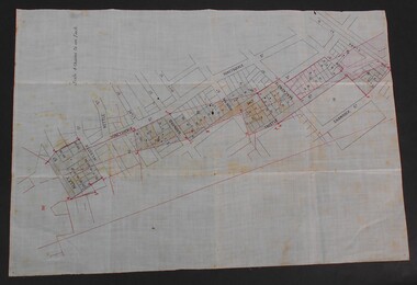
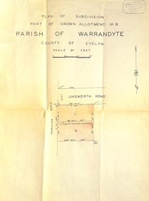 Ringwood and District Historical Society
Document - Plan of Subdivision, Part of Crown Allotment 31B, Parish of Warrandyte, County of Evelyn - (undated, circa 1960s)
Map showing residential allotments numbered 1 and 2 on Through Road and Unsworth Road, Ringwood, Vic., with property dimensions and location of drainage & sewerage easement.H.J. Macey Licensed Surveyor, 36 Nerissa Street, Burwood (Telephone) BX1917. -
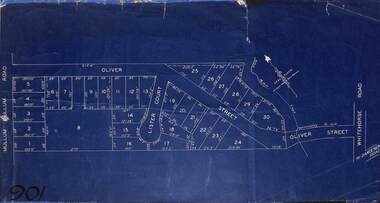 Ringwood and District Historical Society
Map, Subdivision Plan of residential allotments in Mullum Mullum Road, Oliver Street and Lister Court, Ringwood, Victoria - (Undated)
Blueprint copy on cardboard backingNorth directional indicator includes name of Surveyor and Town Planner, Saxil Tuxen. -
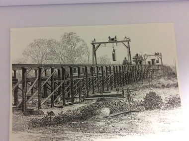 Port of Echuca
A black and white photograph of a drawing, Black and white photograph of a drawing depicting the construction of the iron Murray Bridge, at Echuca, showing Surveyor, bridge workers, hoists, a crane, and much activity, 1981
Original negative and photograph held by The Age, before by Orm Cook, Echuca. Photo is of a drawing of Bridge work taking place in 1877, across Murray River at Echuca. Orm Cook gave The Age the photograph in 1981 as the round arches on the bridge were about to be removed.A bridge crossing of the Murray River was needed by 1877. It linked Echuca and Moama in a more tangible way. The bridge was funded privately and public use of it was discussed for the next several years.A black and white photograph of a drawing, depicting the construction of the iron Murray Bridge at Echuca, showing the Surveyor, the bridge workers, hoists , a crane, and much activity.Written in pen on the back, "Murray Bridge at Echuca under construction. Original to 'Age' came from Orm Cook. Also the numbers 6530 written in pen. Also on the back is a rectangular stamp with these words inside the rectangle. "COPYRIGHT. This photograph may not be reproduced without permission in writing from the Editor of "The Age" 250 Spencer Street, Melbourne, and 39/41 York St, Sydney.murray river, bridge work, bridge construction, bridge workers., the age newspaper., orm cook. -
 Whitehorse Historical Society Inc.
Photograph, Roger N. Hannaker
Black and white photo of Roger N. Hannaker, President Australian Institute Building Surveyors, Vic. Chapter. Also Manager, Buildings, City of Nunawading.hannaker, roger n., australian institute of building surveyors -
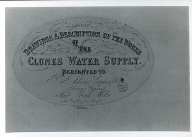 Clunes Museum
Document - MAP
CLUNES WATER SUPPLY DRAWINGS & DESCRIPTIONS OF THE WORKS PRESENTED TO P.F. ADAMS ESQUIRE SURVEYOR GENERAL OF NEW SOUTH WALES WITH OCT. LANGHAMS COMP.DRAWINGS AND DESCRIPTIONS OF THE WORKS OF CLUNES WATER SUPPLY.local history, photography, photographs, water supply -
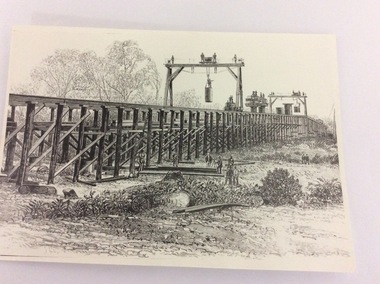 Port of Echuca
Photograph - Black and white photograph of a drawing, A black and white photograph of a drawing of the construction of the bridge crossing the Murray River at Echuca in 1887, 1981
The drawing shows all the activity and building roles involved in building a bridge in 1877. The crossing of the Murray River was very important to citizens living in both Echua, but especially those living in Moama and in further NSW regions as it provided them with access to Victorian market regions. The bridge was built privately for Deniliquin farmers, but eventually opened up to the general public.This is significant because it represents the roles of different tradesmen in the construction industry in the late 19th Century. It also shows construction stages . Bridge pylons are being inserted into the fiver banks. It is also a very well produced drawing, the artist is anonymous, but very skilled.A photograph of a drawing of the construction of the bridge crossing the Murray River in 1877. The picture shows surveyors, construction workers, crane operators, hoists and a crane and much activity.Written on the back in pen are the numbers 6530. In pencil are the numbers 61/8"? and 10"?. Stamped on the back is a small rectangle with the words 'COPYRIGHT. This photograph may not be reproduced without permission in writing from the Editot of "The Age" 250 Spencer Street Melbourne, and 39/41 York St., Sydney.' written inside it.bridge works, murray river crossing, moama, echuca, orm cook collection, 'the age' newspaper., deniliquin farmers, engineering, bridge building, pylons, 1877 -
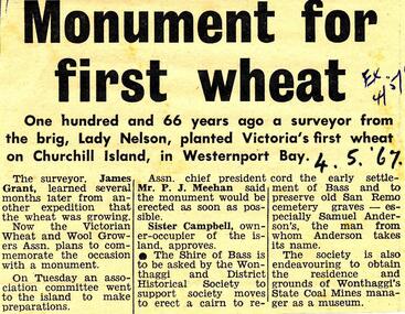 Phillip Island and District Historical Society Inc.
Newspaper Clipping, First Wheat planted in Victoria, 4/5/1967
Collection of newspaper clippings from Scrap Book 1960 - 1973Article about the first wheat planted in Victoria on Churchill Island by surveyor James Grant 166 years ago and a Monument should be erected to commemorate the occassion.first wheat crops for victoria, churchill island, james grant, newspaper clipping, jean jamieson -
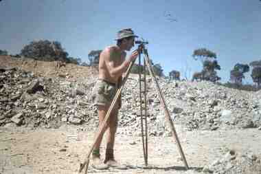 Bendigo Historical Society Inc.
Slide - RALPH BIRRELL COLLECTION: EIG SCHOOL, c1966
EIG School - Ralph Birrell Collection. - Construction of Latrobe Uni. C1966. Bendigo Institute of Technology, Engineering School, Applied Science. Surveying with surveyors tripod.Kodakeducation, tertiary, latrobe university bendigo, eig school - ralph birrell collection. - construction of latrobe uni. c1966. bendigo institute of technology, engineering school, applied science. surveyors tripod. -
Port Melbourne Historical & Preservation Society
Book - Borough of Sandridge/Port Melbourne, Surveyor's correspondence, Charles Clay, Borough Surveyor et al, 1877
Book of Sandridge/Port Melbourne Borough Surveyors' correspondence copies, 1877 - 1890 re various contracts, streets, abattoirs, other engineering projects etc.local government - borough of sandridge, local government - borough of port melbourne, engineering - roads streets lanes and footpaths, arthur victor heath, town clerks, charles clay -
 Port Melbourne Historical & Preservation Society
Map - Track, Sandridge to Melbourne, 1840
Bromide of surveyor's sketch of the track to Melbourne from Sandridge (Liardet's Beach), 1840. Originals with Lands Department, Melbourne. (possibly the work of William Wedge DARKE?)Slight processing stain upper right, '6' on backbusiness and traders - hotels, william wedge darke, piers and wharves -
 Bendigo Historical Society Inc.
Document - WES HARRY COLLETION: SURVEORS MAP ON LINEN OF HONEySUCKLE AND THISTLE STREETS
A surveyor's map to scale 4 chains to 1 inch of Honeysuckle & Thistle Streets, between Alley Street and Clark Street Unknown purpose of the plan - undated -
Port Melbourne Historical & Preservation Society
Plan - Open drainage channel, cnr Beach Street and Railway Place, Port Melbourne, Frederick William Bull, Principal Surveyor, 1862
Plan for open drainage channel at corner of Beach Street and Railway Place, 1892."Open Channel at Foot of Railway Place":Signed by Frederick William Bull, Principal Surveyorengineering - canals and drainage, engineering department - borough of sandridge, frederick william bull, business and traders - hotels -
Port Melbourne Historical & Preservation Society
Plan - Raglan Street, Port Melbourne, Borough of Sandridge, 1890s
Plan of Raglan Street showing longitudinal section.Chas Clay (Borough Surveyor):E. Clark (Town Clerk):John Clang (Contractor ?)raglan street, engineering - roads streets lanes and footpaths, town clerks, charles clay, edward clark -
Stawell Historical Society Inc
Map, H C Bates Surveyor, Plan of Underground Workings. 1888, 25/8/1888
goldMagdala Co Now Moonlight Co StawellScale 80ft to an inch H C Bates Mining Surveyor 25/8/88mining -
 Bacchus Marsh & District Historical Society
Map, O'Hagan v Shire of Bacchus Marsh, Allotment 5, Sec 16, Parish of Korkuperrimul
The purpose for this map being created or the date when it was made has not been established. It appears to be documentation relating to a legal dispute by a landowner named O'Hagan and the Shire of Bacchus Marsh. Features identified on the map are allotment 5, section 16, Parish of Korkuperrimul, a 'cultivation paddock', a section of the Werribee River, the path of a section of a 'Main Channel', and a barrier or filled in section across the Werribee River called 'Lee's Filling'. The O'Hagan is likely to be Patrick O'Hagan, 1829-1914 who arrived in Bacchus Marsh in 1864 and was a prominent citizen and landowner in the area for many years until his death in 1914.Single page map showing allotment 5, section 16 in the Parish of Korkuperrimul, Scale 4 chains to inch. Part of a set of maps which are pasted into a bound volume containing 76 maps or plans in total. High resolution digital image stored on BMDHS computer network. Stamped: Munzt, Bace and Muntz, Civil Engineers and Licensed Surveyors , 388 Collins Streetbacchus marsh victoria maps, water supply structures and establishments, watercourses -
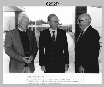 Bendigo Military Museum
Photograph - Retired Officers of the Royal Australian Survey Corp on Corps Day, School of Military Survey, Latchford Barracks, Bonegilla, 1991
This is a photograph of three retired officers from the Royal Australian Survey Corps taken on Corps Day, at the School of Military Survey, Latchford Barracks, Bonegilla in July 1991. BRIG Don Macdonald AM served in the Australian Regular Army from 1st of January 1936 to 22nd of March 1967. He was the Director of the Survey Corps from January 1960 to March 1967. COL Macdonald was promoted to Brigadier before assuming the honorary position of Colonel Commandant of RA Svy from August 1967 to January 1973. LTCOL Bob Skitch served in the Australian Regular Army from 14th of February 1955 to 27th of February 1981. He was the CO of the Army Survey Regiment from 1976 to 1980. LT Leo Noel Fletcher MID served in the Australian Regular Army from 1st January 1938 to 14th November 1945. He was the NSW Surveyor General from 1965 to 1978.This is a photograph of three retired officers from the Royal Australian Survey Corps taken on Corps Day, at the School of Military Survey, Latchford Barracks, Bonegilla in July 1991. The black and white photograph was printed on photographic paper and is part of the Army Survey Regiment’s Collection. The photograph was scanned at 300 dpi. .1) - Photo, black & white, 1991, retired RA Svy officers – L to R: LT Leo Noel Fletcher MID, LTCOL Bob Skitch, BRIG Don Macdonald AM.Annotated on front of photo ‘RASvy Corps Day1991. Three of the Corps past members meet for the first time in many years. Lt Noel Fletcher (ex NSW Surveyor General), Lt Col Bob Skitch and Brig Don MacDonald.’royal australian survey corps, rasvy, army survey regiment, army svy regt, fortuna, asr, school of military survey -
Port Melbourne Historical & Preservation Society
Book - Correspondence, A V HEATH, Town Surveyor, Port Melbourne, Arthur Victor Heath, Town Surveyor, 1894 - 1898
One of two books containing tracing paper copies of letters handwritten by Town Surveyor A.V. HEATH: from 29 January 1896 to 16 February 1898.engineering - roads streets lanes and footpaths, local government - town of port melbourne, local government - borough of port melbourne, engineering - other, arthur victor heath -
 Bendigo Historical Society Inc.
Slide - ALLAN BUDGE COLLECTION: SLIDE HIGH STREET GOLDEN SQUARE, 1988
Slide, ALLAN BUDGE COLLECTION, Polychrome Brickwork, High Street, Golden Square. Features the following information; James Blair; Architect, Building Surveyor, Sworn Valuer.house, public, allan budge collection, allan budge collection -
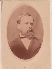 Clunes Museum
Photograph
.1 SEPIA PHOTOGRAPH MOUNTED ON CARDBOARD .2 COPY OF ABOVE PRINTED ON PHOTOGRAPHIC PAPER TOWN CLERK & SURVEYOR, BARTSON, ARTHUR. FROM COLLAGE REG 822local history, photography, photograph, councillors