Showing 724 items matching "145"
-
 Bendigo Historical Society Inc.
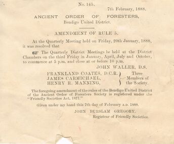
Document - ANCIENT ORDER OF FORESTERS NO. 3770 COLLECTION: CORRESPONDENCE
Printed leaflet dated 7th February 1888 and numbered No. 145. Amendment of Rule 5. At the Meeting held on Friday, 20th January, 1888 it was resolved that the Quarterly District Meetings held at the District Chambers on the third Friday in January, April, July and October, to commence at 5 p.m. and close at or before 10 p.m. Registed under the 'Friendly Societies Act, 1877'. Names on the paper are John Waller, Frankland Coates, James Carmichael, Henry R. Manning and John Burslam Gregory.societies, aof, correspondence, ancient order of foresters no. 3770 collection - correspondence, amendment of rule 5, john waller, frankland coates, james carmichael, henry r manning, friendly societies act 1877, john burslam gregory -
 Glenelg Shire Council Cultural Collection
Photograph - Photograph - Sheet of contact prints, n.d
Port of Portland Authority ArchivesFront: ' 28-10-64 138 28-10-64 139 28-10-64 140 28-10-64 134 28-10-64 145 28-10-64 146' - in white beneath each print Back: 134 139 146 - in pencilport of portland archives -
Lakes Entrance Historical Society
Administrative Record - Ledger, Pound Cash Book, 42108
Entries are hand written in ink on Gelantipy Pound proforma and glued to ledger pages, pages 1 to 14 have been used, leather bound with heavy cardboard cover, pages 15 to 145 are empty, there are also 15 blank proforma pages, contains some loose dockets.A ledger containing details of animals impounded by Gelantipy Poundaccounts book -
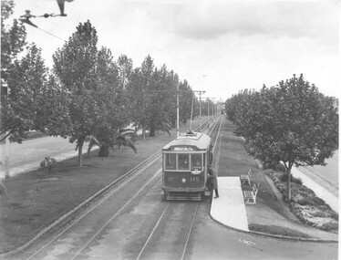 Melbourne Tram Museum
Photograph - Tram 145 Dandenong Road, mid 1920s
Photo shows Q class tram 145 in Dandenong Road, at a stop picking up a male passenger. The tram has the destination of Brighton Cemetery with an Auxiliary board "Via Dandenong Road." The conductor can be seen at the back of the tram observing the passenger boarding. Photo possibly mid 1920s.Yields information about tram services in Dandenong Road during the 1920s and the road itself.Black and white photo with notes on the rear.In ink "new cars Q class 139 - 150, combination straight sill, 7'6 wheelbase, 21E trucks GE203 motrs, 13.027 Tons Tare."trams, tramways, q class, dandenong road, tram 145, brighton cemetery -
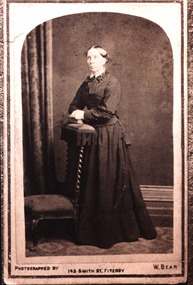 Greensborough Historical Society
Photograph - Digital image, Harriett Walker Stock, 1883c
Harriet Walker Stock, came from England 1861, first to Lower Plenty then to Greensborough. Photographs from the collection of Peter Blackbourn, a descendant of the Chapman Stock family. Annotations to photos by Peter Blackbourn. [Nearly 100 advertisements for W. Bear at 145 Smith Street may be found for years 1882-1883]Digital copy of black and white studio photograph.peter blackbourn, harriett walker stock -
 Seaworks Maritime Museum
Plaque
In 2010, the Government announced that the ETV fleet would be no longer be funded by the MCA from September 2011, saving £32.5m over the Spending Review period. The Department stated that "state provision of ETVs does not represent a correct use of taxpayers money and that ship salvage should be a commercial matter between a ship's operator and the salvor".Two days after the announcement that the fleet was to be disbanded, Anglian Prince was sent to the aid of the UK's newest and largest nuclear submarine HMS Astute, which ran aground off the Isle of Skye in Scotland during sea trials.Builder's plaque, Imai Mfg Co, for the 'Jaramac 48' - Text is impressed into the front and painted red. A red painted border surrounds the edge of the plaque. A small silver plate is attached to the upper right hand corner with engraved text on it.1979 circa. Jaramac 48 - 4,200 HP, Harbour Tug, Built 1975. Renamed 'Mac Tide 48'JARAMC 48/OWNER J. RAY MCDERMOTT & COMPANY INC/ OFFICIAL NO./ GROSS TONNAGE 554t.84/ NET TONNAGE 71t.00/ CONTRACTOR HASEGAWA & CO., LTD./ BUILDER IMAI MFG. CO., LTD/ HULL NO. SHIP NO. 145" Gold Plaque "DONATED BY/ J Ray McDermott (Aust) P/l)/ 1979" -
 Ballarat Tramway Museum
Photograph - Colour Photograph/s, Earl Ewers, 26/12/1999 12:00:00 AM
Colour print of BTM tram No. 40, at Depot Junction on a very wet Boxing Day, 1999. Tram has "Bray Raceway" sign on front drivers panel, with ice cream van in the background. Appeared in colour in the February 2000 of Trolley Wire on Page 44. Printed onto Kodak Royal Paper. Photo by Earl Ewers. Photo taken 26/12/1999.On rear in blue ink "Car No. 40 going about its business at Depot Junction on a very wet Boxing Day 1999." and in bottom right hand corner "Earl Ewers" In centre of photo on rear is label with "Photo / Enlarge to 119% 145 x 100 Colour.", crop marks and a yellow sticker with "59" written on it.btm, depot junction, trolley wire, tram 40 -
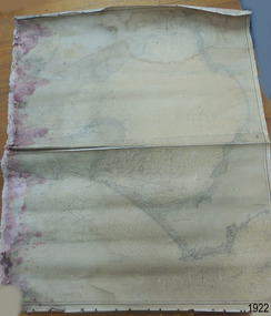 Flagstaff Hill Maritime Museum and Village
Document - Chart, Admiralty Office, Port Phillip, 1899
Accurate charts were imperative for sea farers to sail their vessels safely from one side of the world to another. The British Admiralty published many charts and updated them frequently. Specialists were employed to gather information such as depth soundings to give the navigator as many helps as possible. At regular intervals the charts had to be updated with the amount of adjustment needed to a compass to allow for magnetic variation.This chart is significant for its association with incoming and outgoin ships for trade and passengers in the late 19th century.Admiralty Chart of Port Phillip, Victoria, South Coast of Australia. It shows navigation buoys, lighthouses, tides and money other details. It was surveyed by Commander Henry L. Cox R.N. in 1864. Published by Admiralty August 19th 1865. Corrections were made by Staff Commander E.J. Stanley R.N. in 1874. The West Channel was surveyed b J.B. Mason , Engineer, in 1899. Published and cartographed in Admiralty, London, England in 1897, supervised by Capt G H Richards R N Hydrographer. Chart was updated in 1899. Sold by W D Potter Agent for Admiralty Charts 145 minorities.Printed: "Port Phillip" "Australia - South Coast, Victoria"flagstaff hill, warrnambool, maritime-museum, flagstaff hill maritime museum & village, shipwreck coast, chart, australia, south coast, port phillip, admiralty, 1899, navigation, cartography, cartographer -
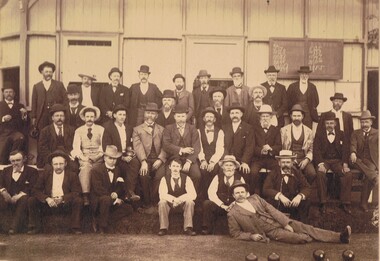 Bendigo Historical Society Inc.
Photograph - GROUP OF MEN IN LAWN BOWLING CLUB, 1900, c.1900
Sepia photograph of 1900 Bendigo Bowling Club. Group of well dressed men outside a building. Men wearing waistcoats, suits, ties, hats. Four bowls (for playing law bowls) right front of photo. Inscriptions: Card, front - R Dermer Smith, Photo Bull St., Bendigo. Card back - GP88. Stamped 'Royal Historical Society of Victoria, Bendigo Branch, 1959, 145)' Paper posted to rear of card. Stamped - 'Royal Historical Society of Victoria, Bendigo Branch' Hand written in stamp '1959', '145'. Hand written in blue ink '1900 Bowling Club'. 'M Yates (Bendigo Station Master), F Brown, Roeder (Hotel Athenaeum), Howel (Band Manager), Town Clerk W Honeybone, Jackson Parker, AJ Pearce (Grammar School), Fred Barder, Pascoe, JA Deravin (Dolfe), WHB Neill, Charley Satchell (Solicitor_, Charlie Fly (Grocer), Andrews (Commercial Traveller), MA Bosselman, Mr WJ Jackson Sen, Mr WJ Jackson Jun. (tailors), John Fly (brother of Charles), Dr. Garnet, Dr. Theodore Deravin. (old Grammar School at back of St Andrews about to be demolished). Not Bendigo. Rear Admiral Dr St---dee, 1893.person, group, sports team -
 National Vietnam Veterans Museum (NVVM)
Medal - Medals, Replica
38324 Signalman Barry Arthur Logan, 552 Signal Troop, 145 Signal Squadron, Age 19, from Mildura, Victoria He was killed in action when the APC in which he was traveling stuck a mine and exploded in Xuyen Loc Province, south west of Saigon on 28th March 1967 while attached to the United States Army 11th Armoured Cavalry Regiment on Operation PORTSEA.1x Australian Active Service medal 1x Australian Service medal 1X Australian Defence medal 1x Republic of Vietnam Campaign medalmedals, australian, barry arthur logan, killed in action, apc, xuyen loc povince, saigon, united states army, 11th armoured cavalry regiment, operation portsea, signalman, 38324, royal australian corps of signals, 709 signal troop, 552 signal troop, mine explosion -
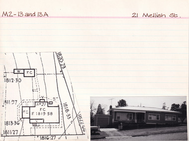 The Beechworth Burke Museum Research Collection
Card (Series) - Index Card, George Tibbits, 21 Mellish Street, Beechworth, 1976
George Tibbits, University of Melbourne. Faculty of Architecture, Building and Town & Regional PlanningIndex system that support the research for Beechworth : historical reconstruction / [by] George Tibbits ... [et al]Arranged by street names of BeechworthEach index card includes: street name and number of property, image of property, allotment and section number, property owners and dates of ownership, description of the property according to rate records, property floor plan with dimensions.beechworth, george tibbitsbeechworth, george tibbits -
 Port Melbourne Historical & Preservation Society
Photograph - Various Port Melbourne locations, 1970s
12 photos taken around Port Melbourne in the 1970s. (01) Rouse st dwellings (02) 61-69 Bay st - two copies (03) Faram Bros hardware (04) 286 Nott St (05) 348 Bay St (06) 244 -246 Nott St (07) Tom BUCKINGHAM clothing shop at 79-85 Bay St - two copies ( 08) 1 Beach St residence (09) Metthodist Church (now demolished) (10) Corner Bay and Rouse Sts, Old Post Office (11) Former fire station at 143-145 Liardet St (12) Nott St Primary schoolfaram brothers hardware, engineering - roads streets lanes and footpaths, built environment, religion - wesleyan methodist church, rouse street, bay street, theodore thomas (tom) buckingham, beach street, post office, fire station, nott street state school -
 Bendigo Historical Society Inc.
Document - LANDS OFFICE, REPORTS OF SALES BY PUBLIC AUCTION, 1864 - 1892
Document: buff leather hard covered journal. On spine on red rectangle ' Land sales by public auction' written in gold. On bottom of spine 'Lands and Survey' written in gold on black. On base of spine '4' printed in black. Pages contain details of sales of crown lands by public auction Act 25, Victoria 145. Alphabetical index of counties inside front cover. 443 numbered pages. LH side columns, number, county, parish, section, allotment sold, unsold, price. RH page - improvements, purchaser, residence, amount, later sales have printed notices pasted in. Dated 27 April 1864 to 7 October 1892.Lands and Survey Dept.place, bendigo, sandhurst, crown land, public land auctions, land sales. -
 Kiewa Valley Historical Society
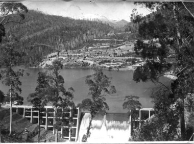
Set of 3 black and white photographs of Lake Guy, Bogong Village and single men's quarters, 1943/44
Construction of Bogong Village was commenced in 1940 and was the Field Headquarters for the early part of the construction of the Kiewa Hydro Electric Scheme. In all, a total of 36 houses, medical centre, police station, trading store and primary school were built. As well, there was a hostel for staff personnel and prefabricated units, each 10 feet x 8 feet, with separate dining and recreational facilities for the worker's. This camp was closed in 1962.These photos show the type of accommodation, available in this period, as well as the benched layout of the village. The damage of the 1939 bushfires is still evident.1. Black and white photo of Junction Dam Wall, Lake Guy and Bogong Village. 2.Black and white photo of single men's quarters at Bogong Village. 3.Lake Guy and Bogong Village.1.Back of photo, Left upper corner - K1334 Upper Right corner - mu (very faint) 6-10-43 2.Back of photo, Left upper corner - K1399 Upper right corner - 14 m 1-2-44 3. Back of photo, left upper corner -K1738 Upper right corner - 145 a mus 5-12-44 bogong village, lake guy, secv -
 Clunes Museum
Artwork, other - FRAMED LITHOGRAPH
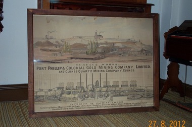
PORT PHILLIP & COLONIAL MINING COMPANY LIMITED AND CLUNES QUARTZ MINING COMPANY, THE MACHINE CONTAINED 5 BOILERS, 3 ENGINES 145 HP, 80 HEADS OF STAMPS, 7 BUDDLES, 2 CHILIAN MILLS & 2 STONE BREAKERS, STEAM VALVES. TONS OF QUARTZ RAISED BY THE PORT MINING & CLUNES COMPANIES TO MARCH 1880 1123365 TONS & GOLD 465,168 OUNCES, 7 DWTS, VALUE 1860, 925,54 POUNDS. EXHIBITED BY R.H. BLAND, CLUNES.LITHOGRAPH DEPICTING SURFACE WORKS OF THE PORT PHILLIP & COLONIAL MINING CO. LIMITED AND INTERIOR OF MACHINE HOUSE.local history, illustrations, lithograph, mining. -
 Bendigo Military Museum
Uniform - TROUSERS, WORK DRESS - ARMY, 2003
DCPU (Disruptive Pattern Camouflage Uniform) Work dress trousers. Colours - light to dark green through to mid to dark brown. Gore-Tex (Polyester/laminate) type fabric for wet weather. Worn as overpants. Drawstring cotton cord at waistband, with plastic look clip. Two side pockets, at ankles loop and hoop adjustable strap. White colour polyester fabric manufacturers label, inside back waist band.Manufacturers information on label - black ink print. " REFLECTIVE/ IMAGES/ O/N G5.202857/ N/S/N 8405/66/145/7099/ AUG 2003/ BATCH: 912726/0004/ SIZE: XL- 82 CM/ NAME:/ SERVICE/ CARE INSTRUCTIONS/ DRY CLEANABLE/ MACHINE WASHABLE 40dc/ DO NOT BLEACH/ DO NOT SPIN DRY/ DO NOT WRING/ HANG TO DRY/ LIGHT/ COOL IRON".uniform, army, work dress, dpcu, trousers -
 Eltham District Historical Society Inc
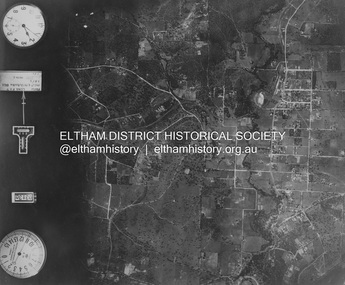
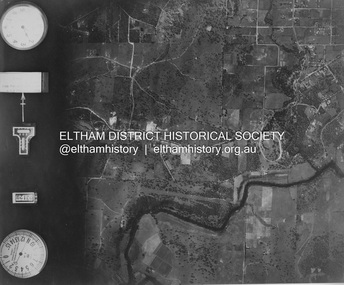
Photograph - Aerial Photograph, Landata, Eltham and Montmorency, Nov. 1931
Centred over present-day Belmont Reserve, Montmorency Historic Aerial Imagery Source: Landata.vic.gov.au Aerial Photo Details: Project No :1931 Project : MALDON PRISON Run : 19 Frame : 3130 Date : 11/1931 Film Type : B/W Camera : F8 Flying Height : 11000 Scale : 18860 Film Number : 60 GDA2020 : 37°43'13"S, 145°07'54"E MGA2020 : 335330, 5823576 (55) Melways : 21 F6 (ed. 42)aerial photo, eltham, neil webster collection, belmont reserve, montmorency, rattray road -
 Eltham District Historical Society Inc
Photograph - Aerial Photograph, Landata, Eltham, Nov. 1931
Centred over Mount Pleasant Road and Kent Hughes Road, Eltham Historic Aerial Imagery Source: Landata.vic.gov.au Aerial Photo Details: Project No :1931 Project : MALDON PRISON Run : 20 Frame : 3137 Date : 11/1931 Film Type : B/W Camera : F8 Flying Height : 11000 Scale : 18860 Film Number : 60 GDA2020 : 37°43'37"S, 145°09'26"E MGA2020 : 337606, 5822892 (55) Melways : 22 A8 (ed. 42) aerial photo, eltham, neil webster collection, kent hughes road, mount pleasant road -
 Port Melbourne Historical & Preservation Society
Photograph - Properties in Farrell Street, Port Melbourne, 2005
Photographic images of properties in Port Melbourne. Image may have been taken by a PMHPS member or scanned from a past resident, or taken for real estate purposes. Properties in Farrell Street. Numbers 116; 117; 118; 119; 121; 122; 123; 125; 126; 127; 128; 129; 130; 131; 132; 133; 134; 135; 136; 137; 138; 140; 141; 143; 144; 145; 147; 149; 150; 151; 152; 153; 154; 155; 156; 157; 159; 160; 161; 163; 164; 165; 167; 168; 170; 174; 175; 176; 177; 178; 180; All photos appear to be taken in September 2005, except 149 and 126 (March 2015).built environment - domestic, farrell strett -
 Tennis Australia
Trophy, 1973
Two part (bottle & lid) glazed ceramic trophy for 'CLINT EASTWOOD/INVITATIONAL/CELEBRITY TENNIS/TOURNAMENT'. Trophy is also a bottle of Beam whiskey, as per label on base: 'BEAM/100 MONTHS OLD/KENTUCKY BOURBON WHISKEY/86 PROOF/ BOTTLED BY JAMES B. BEAM DISTILLING CO. CLERMONT- BEAM, KENTUCKY'. Sticker on front stating:'OKLAHOMA/LIQUOR TAX PAID/12 GALLON'. Text on rear of vessel states: 'PEBBLE BEACH/JULY, 1973'. Text embossed under base states: 'CREATION OF JAMES B. BEAM/DISTILLING CO./KY-DRB-230/GENUINE REGAL CHINA 1973/C.MILLER/REGAL CHINA CORPORATION/145/LIQUOR BOTTLE'. Materials: Ceramic, Cork, Adhesive labeltennis -
 Melbourne Legacy
Journal - Newsletter, Legacy Newsletter 1984-1986 (For the members of the Melbourne Legacy Widows' Club), 1984 to 1986
Examples of Melbourne Legacy Club newsletters, covering the activities of Melbourne Legacy Widows' Club. Information includes a notice from the Chairman of the Widows' Committee, dates of meetings, possible day trips and theatre outings, and cruises. The ladies were welcome to attend monthly meetings, card afternoons, indoor bowls competitions, outings and tours, plus the annual fete and Christmas concert. The first edition of the newsletter was in 1960, previously there had been a quarterly magazine but the distribution was limited, they changed to a 4 page newsletter format to reach more of the widows. Various pages of interest have been added to show different news items. Other editions haven't been scanned.Brings to life the activities provided for the widows and the work of Melbourne Legacy in the early years.Black typed newsletter x 19 editions from 1984 to 1986, No 143 to 160, each edition 6 foolscap pages. No 143, 31 January 1984 No 144, 31 March 1984 No 145, 31 May 1984 No 146, 31 July 1984 No 147, 30 September 1984 No 148, 30 November 1984 No 149, - MISSING No 150, 31 March 1985 No 151, 31 May 1985 No 152, 31 July 1985 No 152 (2) 30 September 1985 No 153, November 1985 No 154, January 1986 No 155, March 1986 No 157, May 1986 No 158, July 1986, 8 pages No 159, September 1986, 8 pages No 160, November 1986newsletter, activities -
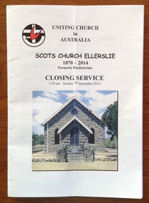 Warrnambool and District Historical Society Inc.
Programme - Scots Church Ellerslie 1870-2014 Closing Service, 2014
The foundation stone of the Scots Church Ellerslie was laid by Mrs Jemima Vans Robertson on 1st November 1870. She was the leader and benefactor of the church. Worship services were held in the church for the next 145 years. The Sunday School was started in1871 and until 1977 Ellerslie was part of the Framlingham Presbyterian Charge. The PFA for young people was very active in the 1950s and 60s. Since 1977 the Ellerslie church has been part of the Uniting Church in Australia and was an integral part of the Mortlake Parish. The church closed in 2014 and marked for sale. This program is of some interest as it gives us a short history of Scots Church in Ellerslie and tells of its closure in 2014. This is a program for the closing of Scots Church Ellerslie (2014). It has five double pages with printed material and colour photographs. The pages are stapled together.Front Cover: Uniting Church in Australia, Scots Church Ellerslie 1870-2014 Formerly Presbyterian, Closing Service, 1.30 p.m. Sunday 7th December 2014ellerslie, scots church, presbyterian church, uniting church -
 Eltham District Historical Society Inc
Photograph - Aerial Photograph, Landata, Eltham and Lower Plenty, Nov. 1931
Centred over present-day Rosehill Road and View Road, Lower Plenty Historic Aerial Imagery Source: Landata.vic.gov.au Aerial Photo Details: Project No :1931 Project : MALDON PRISON Run : 19 Frame : 3129 Date : 11/1931 Film Type : B/W Camera : F8 Flying Height : 11000 Scale : 18860 Film Number : 60 GDA2020 : 37°44'16"S, 145°07'40"E MGA2020 : 335039, 5821622 (55) Melways : 21 E11 (ed. 42)aerial photo, eltham, lower plenty, neil webster collection, rosehill road, view road -
 Eltham District Historical Society Inc
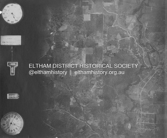
Photograph - Aerial Photograph, Landata, Eltham and Eltham North, Nov. 1931
Centred over present-day Opal Court and Manning Road, Eltham North Historic Aerial Imagery Source: Landata.vic.gov.au Aerial Photo Details: Project No :1931 Project : MALDON PRISON Run : 19 Frame : 3131 Date : 11/1931 Film Type : B/W Camera : F8 Flying Height : 11000 Scale : 18860 Film Number : 60 GDA2020 : 37°42'10"S, 145°08'07"E MGA2020 : 335621, 5825531 (55) Melways : 21 G2 (ed. 42)aerial photo, eltham, neil webster collection, eltham north, manning road, opal court -
 Eltham District Historical Society Inc
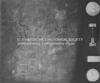
Photograph - Aerial Photograph, Landata, Eltham and Eltham East, Nov. 1931
Centred over present-day Beard Street bewteen Park Road and Main Road, Eltham East Historic Aerial Imagery Source: Landata.vic.gov.au Aerial Photo Details: Project No :1931 Project : MALDON PRISON Run : 20 Frame : 3135 Date : 11/1931 Film Type : B/W Camera : F8 Flying Height : 11000 Scale : 18860 Film Number : 60 GDA2020 : 37°42'16"S, 145°09'41"E MGA2020 : 337912, 5825386 (55) Melways : 22 B2 (ed. 42)aerial photo, eltham, neil webster collection, beard street, eltham east, main road, park road -
 Eltham District Historical Society Inc
Photograph - Aerial Photograph, Landata, Eltham, Nov. 1931
Centred over present-day Laleham Court between Arthur Street and Hartland Way, Eltham Historic Aerial Imagery Source: Landata.vic.gov.au Aerial Photo Details: Project No :1931 Project : MALDON PRISON Run : 20 Frame : 3136 Date : 11/1931 Film Type : B/W Camera : F8 Flying Height : 11000 Scale : 18860 Film Number : 60 GDA2020 : 37°42'56"S, 145°09'33"E MGA2020 : 337759, 5824139 (55) Melways : 22 B5 (ed. 42) aerial photo, eltham, neil webster collection, arthur street, hartland way, laleham court -
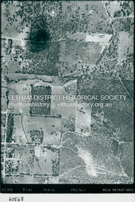 Eltham District Historical Society Inc
Photograph - Aerial Photograph, Landata, Eltham, Luck St; Bible St to Beard St, Dec. 1945
Centred on present day Eltham East Primary School, east of Main Rd along Luck St to Beard St Historic Aerial Imagery Source: Landata.vic.gov.au Aerial Photo Details: Project No :5 Project : MELBOURNE AND METROPOLITAN AREA PROJECT Run : 36 Frame : 60548 Date : 12/1945 Film Type : B/W Camera : EAG4 Flying Height : 10200 Scale : 6000 Film Number : 195 GDA2020 : 37°42'46"S, 145°09'18"E MGA2020 : 337371, 5824456 (55) Melways : 22 A4 (ed. 42)aerial photo, eltham, arthur street, beard street, bible street, eltham east primary school, frank street, henry street, luck street, stanley avenue, wycliffe crescent, neil webster collection -
 Eltham District Historical Society Inc
Photograph - Aerial Photograph, Landata, Eltham, Main Rd; Railway Rd to Zig Zag Rd, Dec. 1945
Centred on present day Edendale Farm from Glen Park rd to Zig Zag Rd Historic Aerial Imagery Source: Landata.vic.gov.au Aerial Photo Details: Project No :5 Project : MELBOURNE AND METROPOLITAN AREA PROJECT Run : 37 Frame : 60549 Date : 12/1945 Film Type : B/W Camera : EAG4 Flying Height : 10200 Scale : 6000 Film Number : 196 GDA2020 : 37°42'12"S, 145°09'09"E MGA2020 : 337141, 5825486 (55) Melways : 21 K2 (ed. 42)aerial photo, eltham, edendale farm, eltham - yarra glen road, eltham-hurstbridge railway line, gastons homestead, gastons road, glen park road, main road, park road, railway road, wattletree road, zig zag road, neil webster collection -
 Kew Historical Society Inc
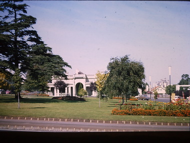
Photograph - South Esk - Cotham Road (Kew), Ron Setford, 1967
Ron Setford and his wife Grace Setford lived in Tanner Avenue, East Kew, from c.1946 to c.1995. A keen photographer, he recorded the changing face of Kew over a 20 year period. Apart from 30 photographs of built structures and places in Kew dating from 1960 and 1961, 145 of his 35mm colour slides chronicle the development of the Eastern Freeway through the Yarra Valley over a five year period from c.1972 to c.1977. This important collection was donated to the Society by his granddaughter in 2025.This collection of 175 35mm slides is of local and statewide significance, owing to its subject matter, particularly the major development of road transport infrastructure during the 1970s with the construction of the Eastern Freeway. The photographer also took care to annotate and date most of his slides which enable the researcher to pinpoint temporal and spatial locations."South Esk / May 1967"ron setford, south esk - kew (vic.), historic houses -- kew (vic.) -
 Kew Historical Society Inc
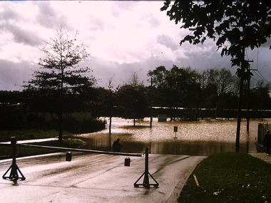
Photograph - Flooding - Kilby Road (Kew), Ron Setford, 1974
Ron Setford and his wife Grace Setford lived in Tanner Avenue, East Kew, from c.1946 to c.1995. A keen photographer, he recorded the changing face of Kew over a 20 year period. Apart from 30 photographs of built structures and places in Kew dating from 1960 and 1961, 145 of his 35mm colour slides chronicle the development of the Eastern Freeway through the Yarra Valley over a five year period from c.1972 to c.1977. This important collection was donated to the Society by his granddaughter in 2025.This collection of 175 35mm slides is of local and statewide significance, owing to its subject matter, particularly the major development of road transport infrastructure during the 1970s with the construction of the Eastern Freeway. The photographer also took care to annotate and date most of his slides which enable the researcher to pinpoint temporal and spatial locations."Flood Kilby Rd / May 74"ron setford, floods -- kew (vic.), kilby road -- kew (vic.)