Showing 1506 items matching "acres"
-
 Bendigo Historical Society Inc.
Map - CAMPBELL COLLECTION: BENDIGO AND DISTRICT MAPS
Map. Longlea, Parishes of Eppalock and Axedale. Scale 20 chains to 1 inch. Total area of map 2372 acres, with Bendigo 9 1/2 miles away. H.A. Darby 18-6-29. (number 349 in map cupboard 1)H.A Darbymap, bendigo, allotments -
 Bendigo Historical Society Inc.
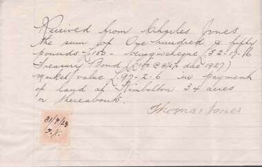
Document - L. PROUT COLLECTION: HANDWRITTEN RECEIPT
Handwritten receipt signed by Thomas Jones acknowledging he received from Charles Jones the sum of 150 pounds in payment of land at Kimbolton 34 acres or thereabouts. A two pence stamp duty is affixed the the letter and the date 31/08/23 is on the stamp.document -
 Bendigo Historical Society Inc.
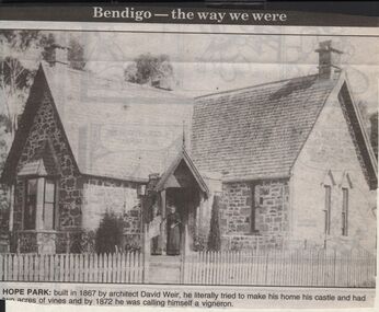
Newspaper - JENNY FOLEY COLLECTION: HOPE PARK
Bendigo Advertiser "The way we were" from 1999. Hope park: built in 1867 by architect David Weir, he literally tried to make his home his castle and had two acres of vines and by 1872 he was calling himself a vigneron.newspaper, bendigo advertiser, the way we were -
 Whitehorse Historical Society Inc.
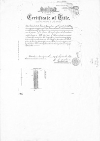
Administrative record - Document, Certificate of Title, 1/09/1909
Photocopy of Certificate Vol. 3352 Fol 335 to Freehold Assets Co Ltd 29 September 1909 for fifty acres fronting on South Side of Canterbury Road, part Crown Portion 94; including record of subdivision transfers 1909 - 1916 and 1992.land subdivision, .freehold assets company limited, glebe street forest hill, crittle, thomas nathaniel, henwood, william, mcarthur, john, draeger, carl julius otto, jay, daniel, barnes, john thomas, mary ann, kleinert, beatrice annie, stanley ernest -
Clunes Museum
Plan, 23RD SEPTEMBER,1854
GEOLOGICAL SKETCH PLAN AND LETTER FOR TWO RIGHTS CLAIMED BY DONALD CAMERON AT "CLUNES" - 320 ACRES IN THE WEST SIDE OF "CRESWICK CREEK" AND 160 ACRES IN EAST SIDE.1 .2 HANDWRITTEN GEOLOGICAL SKETCH/PLAN COMBINED WITH CORRESPONDENCE DATED 23 SEPTEMBER 1854 - FROM THOMAS BURR, SURVEYOR, 1854 AND PROVIDED TO THE SURVEYOR GENERAL. IT RELATED TO TWO RIGHTS CLAIMS BY PRESCRIPTION OF DONALD CAMERON ESQ.local history, plan, donald cameron, thomas burr, gold mining -
University of Melbourne, Burnley Campus Archives
Newspaper - Newspaper Cutting, The Age, The News of the Day, 1861
Photocopy of article in "The Age" 6 June, 1861 p5. Description of the Monthly Meeting of the Committee of the Horticultural Society of Victoria. Progress on fencing and clearing of 11 acres, cottage built for foreman. Dr Mueller had given a very valuable collection of trees, plants and shrubs.the age, rhsv, royal horticultural society of victoria, von mueller, donation of plants, fencing, establishment of experimental gardens, burnley gardens, cottage, foreman, curator, monthly meeting -
 Orbost & District Historical Society
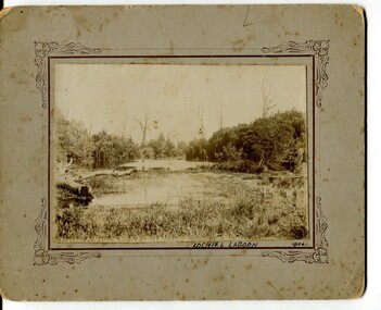
black and white photographs, 1906
These photographs are of Lochiel "Lagoon next to the Cameron House, "Lochiel" owned by James Cameron. The three Cameron brothers had entered into a partnership - John selected 200 acres, James 235 acres and Alex. 273 acres, all adjoining. They also took up 'Lochiel' under the suburban lot scheme. The 'Lochiel‟ property went to James on the dissolution of the partnership.This is a pictorial record of Orbost in the early 20th century. This item is also associated with James Cameron, a prominent early Orbost identity. 3125.1 is a black / white photograph on grey card. It is of a lagoon surrounded by trees, grasses. 3125.2 is a black / white photograph of a lagoon showing a fence on the left side,with two men (one holding a baby), a child and a dog in front of the fence on the bank.on front of 3125.1 - Lochiel Lagoon 1906lochiel-orbost cameron-james -
University of Melbourne, Burnley Campus Archives
Plan, School of Horticulture - Burnley, 1957
(1) Plan of whole site dated 22.05.1957, marked into different areas by letter with key for size of area, proposed new buildings, existing permanent and temporary buildings. New inclusion of about 1 acre hand drawn (behind Administration Building). "Burnley Areas," handwritten on reverse. (2) Handwritten notes (T.H. Kneen): Table with area, size sq ft, size acres, of Stockman's Cottage, Grazing area, Ornamental, New extension, Crops - Controlled by School (Plant Breeding, Agrostology, Biology, Egg-laying Competition) - Controlled by Other Branches. From T.H. Kneen files. On same plan as B91.0484 (original) and B91.0476.t.h. kneen, burnley gardens, burnley school of horticulture, stockmans' cottage -
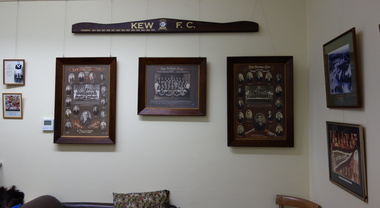 Kew Historical Society Inc
Photograph - Series, Sport in Kew Exhibitions, 2014
The Kew Historical Society, founded in 1958, is one of the oldest continuing historical societies in the Greater Melbourne region. From its beginnings, the Society has mounted exhibitions and/or displays, in early days in shop windows and in community spaces located in the Kew City Hall (later Kew Library), and since 2010 at the Kew Court House. Exhibitions typically coincided with the annual Kew Community Festival in March, but after 2013 evolved into three new exhibitions yearly at the Kew Court House. Smaller displays continue to be mounted in the Kew Library. A series of born digital photographs of an exhibition mounted at the Kew Court House and or Kew Library in 2014 involving photographs and artefacts from the Kew Croquet Club, the Kew Football Club, the Kew Golf Club, the Green Acres Golf Club and the North Kew Tennis Club. kew historical society - exhibitions, exhibition - sport in kew (vic) -
 Bendigo Historical Society Inc.
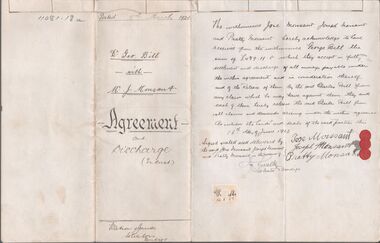
Legal record - BILL Dr. George - Agreement and Discharge, Watson, James & Rogers, Rogers Collection, 1924 - 1925
In the early 1980s the firm of Watson, James & Rogers merged with the partnership of Every & Every and became the iconic “Rogers & Every” as known today. The firm is still located on Bull Street. https://rogersevery.com.au/about/* Agreement and Discharge between George Bill of Homebush and Jose Monsant, Joseph Monsant and Pratty Monsant. Agreement concerns 30 acres of land. Dated 5 March 1924. * Hand written note acknowledging receipt of agreement. Dated July 1925. Signed Geo. Bill.Signatureswatson james & rogers, bendigo, legal documents, monsant -
 Bendigo Historical Society Inc.
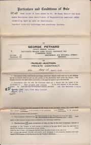
Document - H.A. & S.R. WILKINSON COLLECTION: CONDITION OF SALE
Condition of sale by private contract dated 30th May, 1925 between E. Dobbie and F. C. Neivandt for land at 20 Casey Street held under residence area certificate of registration No. 10890 containing half an acre, together with all buildings. Price 155 pounds.organization, business, h.a. & s.r wilkinson real estate -
 Bendigo Historical Society Inc.
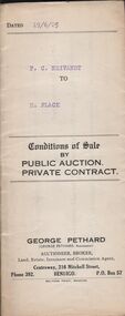
Document - H.A. & S.R. WILKINSON COLLECTION: CONDITION OF SALE
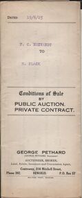
Conditions of sale by private contract dated 19th June, 1925 between F. C. Neivandt and F. Flack for land at 20 Casey Street and held under residence area certificate of registration No. 10890 containing half an acre, together with all buildings. Price 185 poundsorganization, business, h.a. & s.r wilkinson real estate -
 Bendigo Historical Society Inc.
Document - H.A. & S.R. WILKINSON COLLECTION: CONDITION OF SALE
Conditions of sale by private contract dated 19th June, 1925 between F. C. Neivandt and F. Flack for land at 20 Casey Street and held under residence area certificate of registration No. 10890 containing half an acre, together with all buildings. Price 185 poundsorganization, business, h.a. & s.r wilkinson real estate -
Bendigo Historical Society Inc.
Map - CAMPBELL COLLECTION: BENDIGO AND DISTRICT MAPS, 18-6 29
Map. Longlea, Parishes of Axedale and Eppalock, scale 20 chains to 1 inch, total area 2372 acres. Prepared from Assessment Plan and Parish Plan by H.A. Darby18-6-29., Wondong, Heathcote and Sandhurst line (Railway). (number 386 in map cupboard 1)H.A.Darbymap, bendigo, agricultural lands -
Bendigo Historical Society Inc.
Map - CAMPBELL COLLECTION: BENDIGO & DISTRICT MAPS
Map. Lockwood, Parishes of Lockwood and Shelbourne. Scale 20 chains to 1 inch.Total area 4405 acres. Bullock Creek to the right, Spring Creek at Centre. Newbridge is 11 miles N E, To Marong, Bendigo Lockwood roads are on the left. (number 375 in map cupboard 1)map, bendigo, agricultural lands -
 Mont De Lancey
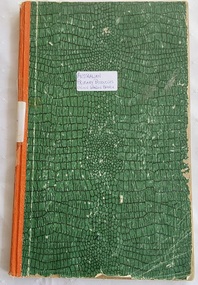
Book, Australian Primary Producers Union Wandin Branch Minute Book
This blank book was used by The Australian Primary Producers Union Wandin Branch. Minutes of the first meeting were taken Nov 20th 1947 in the Seville Hall and the last minutes were on 23.11.1954.A large green paper patterned covered Minute Book with orange tape on the spine. This blank book was used by The Australian Primary Producers Union Wandin Branch. Minutes of the first meeting were taken Nov 20th 1947 in the Seville Hall and the last minutes were on 23.11.1954. The book is filled with Minutes of meetings and has two paper insertions - a paper photopcopy of an Invoice Wandin Yallock April 30th1909. Mr Aitken for The Evelyn Preserving Co. Limited Manufacturers of Pure Jams and Jellies. Terms Cash. On the same paper The Colonial Bank of Australasia Limited stating a Sale and acknowledgement receipt of a letter and the enclosure of a remittance, signed by the manager. The second insertion is dated Sept 1950 - a Survey of cost of Production Berry Fruit Wandin Silvan Area. Youngberries. Based on Land at 100 pounds per acre and average 2 ton crop. Full details are listed.non-fictionThis blank book was used by The Australian Primary Producers Union Wandin Branch. Minutes of the first meeting were taken Nov 20th 1947 in the Seville Hall and the last minutes were on 23.11.1954. meetings, reports, proceedings, minutes of meetings -
 Federation University Historical Collection
Photograph - Colour, Chatham-Holmes Collection: Trawalla Estate, Victoria - Soldier Settlement
In 1917 a large part of the Trawalla estate was acquired and subdivided by the Commonwealth Government for the Soldier Settlement Scheme. Land was subdivided into 93 allotments with sizes from 250 acres to 680 acres. The land was deemed appropriate for grazing and farming.chatham-holmes collection, soldier settlement, langi kal kal, auction, philip chatham, trawalla -
 Eltham District Historical Society Inc
Book - Farm Ledger, Palmer Farm, Cassells Road, Research, Vic, 1912-1923
The Palmer farm was on Cassells Road and consisted of 100 acres extending to present-day Eltham College ovals. It was sold in the 1940s but 10 acres was retained. The Palmer family moved there circa 1910 The ledger covers the period 1912-1923. palmer family, palmer farm, cassells road, research (vic.) -
Bendigo Historical Society Inc.
Map - CAMPBELL COLLECTION: BENDIGO AND DISTRICT MAPS, 2-2-29
Map. Wellsford, Parishes of Wellsford and Axedale, Scale 20 chains to 1 inch. Total area 4994 acres. Prepared in W.P.B. from A and P Plans, by W.J.G.2-2-29. Top left of map are directions to Fosterville, Huntly & Bendigo. (number 361 in map cupboard 1)W.J.Galbraithmap, bendigo, parish plan -
Bendigo Historical Society Inc.
Map - CAMPBELL COLLECTION: BENDIGO AND DISTRICT MAPS
Map. Whirrakee, Parish of Whirrakee. Total area of map 4419 acres. Scale 20 chains to 1 inch. 23 allotments are sold, Eucalypt oil distillery on lower portion of map. Prepared in W.P.B. from Assessor's plan and Parish Plan. (number 350 in map cupboard 1)map, bendigo, allotments -
 Whitehorse Historical Society Inc.
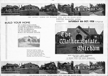
Document, Walker Estate, 1/10/1938
Brochure for auction, 8 October 1938 of Walker Estate, Mitcham. 9 room brick residence and 11/2 acres of grounds, subdivided into 12 building sites for brick residences. House built for E.E. Walker by Louis Hatherley. Auctioneers: Edward Haughton Pty Ltd and Drake & Co.land subdivision, walker estate, walker, edgar edwardes, hatherley, louis, meerut street, mitcham, mitcham road, agra street, simla street -
 Eltham District Historical Society Inc
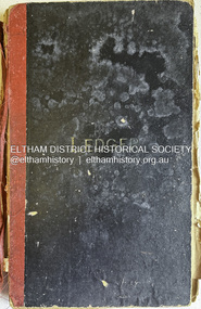
Ledger, Eltham Road District. Assessment for the Year ending Oct. 14th, 1858, 1857c
The Eltham Roads Board was established in 1856. This is a unique significant record of early settlers in the Shire of Eltham. One of 6 early rate books. This is among the oldest items in the EDHS collection. An article in the Eltham and Whittlesea Shires Advertiser Friday 21 Nov 1941 Page 5 titled: District's Early History states: "The first rate book which is still in existence at the Shire Office is for the year ending October 14, 1858 and is probably the best record possible to indicate the development of the district. At the time properties were rated as follows: Cultivated land. 6d. per acre; pasture land, 1d. per acre: estimated annual value of buildings, etc., 6d in the (pound). The total amount of rate recorded for the year was (pounds)153/14/8. Properties were described as being situated at Lower Plenty, Yarra Yarra, Eltham, Lower Eltham, Kangaroo Ground, Yarra Flats, Diamond Creek and the Yarra."Ledger with printed columns: Number, Name of Occupier, Description, Where situated, Cultivated land, Pasture land, Estimated annual value of buildings, Rate, Remarks. Ledger filled out by hand with 152 entries (not alphabetically arranged). A number of blank pages are included. Copy re-bound in green hard leather look card by Arnall & Jackson Pty Ltd Brunswick, 1968 Inside cover includes a compliments slip taped to the cover from Arnall & Jackson Pty Ltd. with handwritten inscription: "Ian, I hope the hysterical society doesn't get historical about this". Organised 1968 I. Maynard Inside cover includes pasted printed note: RATE OF ASSESSMENT AS FOLLOWS: Cultivated land 6d per acre Pasture land 1 per acre Estimated Annual Value of Buildings, &c., 6d. in the Pound eltham roads board, rate book, rate payers, transaction, pioneers, settlers, 1858, assessment ledger, eltham road district, public records office victoria (prov), rate books, shire of eltham archives -
Bendigo Historical Society Inc.
Map - CAMPBELL COLLECTION: BENDIGO AND DISTRICT MAPS, 22-3-29
Map. Marong, Parishes of Marong, Lockwood and Mandurang, Scale 20 chains to 1 inch, Total area 5106 acres. Crusoe Reservoir & Viaduct and water race. Compiled in W.P.B. fro Field Survey and Parish Plans. B.W.L.22-3-29 (number 389 in map cupboard 1)B.W.L.map, bendigo, allotments -
Whitehorse Historical Society Inc.
Document, Francis Ainger, n.d
An extract from 'The History of Victoria', Melbourne about Francis Ainger, born in England, arrived in Victoria 1856. He found gold at Bendigo and founded a carrying business between the principal goldfields. In 1867 he selected 80 acres at Mitcham, cultivated English grasses and an orchard. Established a Congregational Church.ainger, frank, congregational church -
Tatura Irrigation & Wartime Camps Museum
Photograph, Eildon Reservoir - Goulburn River, 1918
Taken by photographer for State Rivers and Water Supply Commission.Medium sized black and white photograph. Eildon Reservoir on the Goulburn River / Overall picture of dam (Right of wall) filled with water and some leisure craft moored near shore and huts / Dam wall and spillway / tree covered hills beyond"Eildon Reservoir - Goulburn River / Capacity - 306,000 acre feet / Rock filled dam with mass concrete spillway / Total length of dam - 3000 feet / Maximum depth of water - 123 feet - etc"victorian state rivers and supply commission, eildon dam -
 Eltham District Historical Society Inc
Negative - Photograph, Kinglake National Park; view from the Mountain Trail
The Kinglake National Park was established on 11,300 acres in the Shire of Eltham in 1928.This photo forms part of a collection of photographs gathered by the Shire of Eltham for their centenary project book,"Pioneers and Painters: 100 years of the Shire of Eltham" by Alan Marshall (1971). The collection of over 500 images is held in partnership between Eltham District Historical Society and Yarra Plenty Regional Library (Eltham Library) and is now formally known as 'The Shire of Eltham Pioneers Photograph Collection.' It is significant in being the first community sourced collection representing the places and people of the Shire's first one hundred years.Digital image 4 x 5 inch B&W Negsepp, shire of eltham pioneers photograph collection, kinglake, kinglake national park, mountain trail -
 Bendigo Historical Society Inc.
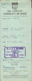
Document - H.A. & S.R. WILKINSON COLLECTION: CONTRACT OF SALE
Contract of sale dated 15th April, 1959 between Mr. F. Kupke (seller) and Mr. P. 7 Mrs. F.E. Stevens (buyers). Solicitor for vendor: Hyett, Willis & Hyett, Bull Street, Bendigo. Solicitor for purchaser: E.S. Cahill & Son, View Street, Bendigo. Property in Sparrow Hawk Road, St. Just Point being allotments 65 and 66 section L containing 15 acres, 17 perches and being land described in Crown grant volume 7615 folio 125, together with all buildings and erections thereon, also stainless steel sink and cupboards. Also State Rivers and Water Supply Authority to irrigate for 3 acres. Price 1,000 pounds.organization, business, h.a. & s.r wilkinson real estate -
 Bendigo Historical Society Inc.
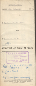
Document - H.A. & S.R. WILKINSON COLLECTION: CONTRACT OF SALE
Contract of sale of land dated 10th February, 1956 between Mr. T.J.K. Gilbert (seller) and Mr. L.F. Rule (buyer) for land being allotment 14p section L, containing 19 acres 3 roods and being land described in certificate of title volume 6375 folio 936 and situate Marong Road, Bendigo. Together with all buildings thereon, also piping and loose galvanized iron on ground, with State Rivers and Water Supply Authority to irrigate 1 acre land. Price 650 pounds. Also attached a letter in two copies signed by Mr. Rule agreeing to the purchase, the letter is dated 7th February, 1956 and is on H.A & S.R. Wilkinson letterhead.organization, business, h.a. & s.r wilkinson real estate -
 Kiewa Valley Historical Society
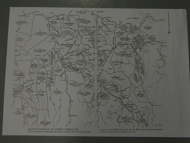
Maps - Squatting Runs of the Murray District 1848 x2, July 26,1848
The Port Phillip Gazette was the second newspaper published in Melbourne, in the then Port Phillip district, now Victoria. In 1948 it was published bi-weekly.The map shows the original names of squatters along the Kiewa River. The names of the district are mostly current today although some are spelt differently.2 copies - 1 laminated & 1 paper of the map of "Squatting Runs of the Murray District 1848." The area is recorded (eg. Tawanga, Dederang, Gundowring, Kergunia, Merrimarenbung all along the Kiewa River) under which the names of the squatter is recorded, the number of acres and the licence number. Scale is 8 miles to the inch.squatting runs; kiewa valley; port phillip district; -
Bendigo Historical Society Inc.
Map - CAMPBELL COLLECTION: BENDIGO AND DISTRICT MAPS, 8-6 29
Map. Kimbolton, Parishes of Kimbolton and Lyell, scale 20 chains to 1 inch. Area by Plamimeter 6258 acres. Coliban River, Knowsley, Strathfieldsaye 10 1/2 miles. Prepared in W.P.B. from Parish and Assessor's Plans. G.W.Latimer 8-6-29. (number 393 in map cupboard 1)G.W.Latimermap, bendigo, allotments