Showing 810 items matching "aerial view"
-
 Greensborough Historical Society
Photograph - Digital image, Frank Solomon, Pig Farm, Weidlich Road area: aerial view, 02/08/2009
... Pig Farm, Weidlich Road area: aerial view...An aerial view of the pig farm in Weidlich Road... Plenty Lower Plenty melbourne An aerial view of the pig farm ...An aerial view of the pig farm in Weidlich Road Greensborough, owned by Werner Hanusch. The land was used as a pig farm and quarry from 1954 and has now been subdivided into the Evelyn Way estate. This project of fifty, one double storey, dwellings was commenced on 2/8/2009 and completed on 6/2/2011.An example of the changing land use in Greensborough, from farming to residential.Digital copy of aerial photographwerner otto fritz hanusch, pig farm st helena, weidlich road greensborough, one evelyn way greensborough -
 Phillip Island and District Historical Society Inc.
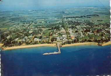
Photograph, 1960 - 1973
... Colour photograph - postcard - aerial view of Cowes..."Aerial view of Cowes"... Jean Jamieson "Aerial view of Cowes" Colour photograph ...One of a Postcard Series.Colour photograph - postcard - aerial view of Cowes"Aerial view of Cowes"local history, newspapers, aerial photograph, cowes, coloured photograph, phillip island, jean jamieson -
 Port Melbourne Historical & Preservation Society
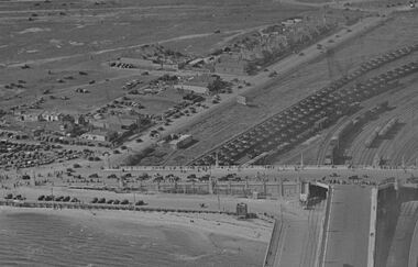
Photograph - Aerial view Centenary Bridge, Swallow St, forecourt Station Pier, Railyards
... Aerial view Centenary Bridge, Swallow St, forecourt Station...Aerial view of Centenary Bridge, Swallow Street... and wharves Railyards Swallow Street Aerial view of Centenary Bridge ...While there are many vehicles and pedestrians on the bridge and on Swallow Street, there is no action on the pier. Circa 1940Aerial view of Centenary Bridge, Swallow Street and Railyards. Circa 1940. Taken at same time as catalogue 5001 but with less view of Station Pier. An event of some sort had been on as there are many pedestrians and vehicles on Centenary Bridge and Swallow St, but it appears the pier was not the focus.piers and wharves, railyards, swallow street -
 Whitehorse Historical Society Inc.
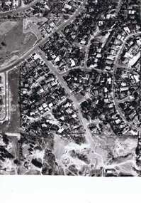
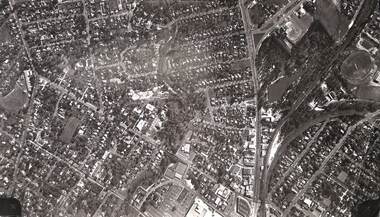
Photograph, Aerial View of various sites in Nunawading, C.1970's
... Aerial View of various sites in Nunawading....2 Black and white copies of Aerial View of various sites... Black and white copies of Aerial View of various sites ...2 Black and white copies of Aerial View of various sites in Nunawading. - Mitcham Technical School, Walker Park , Nunawading Police Station, Bunnings Warehouse, Mobile Industrial Equipment Ltd, Municipal Chambers, Nunawading Library, Turner Industries, Harvey Norman, Feiglins Timber Yard, Holeproof ,Agfa, York Industries and|City of Nunawading. Council Depot.mitcham technical school, walker park, nunawading police station, bunnings warehouse nunawading, mobile industrial equipment ltd., city of nunawading. council chambers, nunawading library, turner industries, harvey norman, feiglins timber yard, holeproof, agfa, york industries, city of nunawading. council depot -
 Otway Districts Historical Society
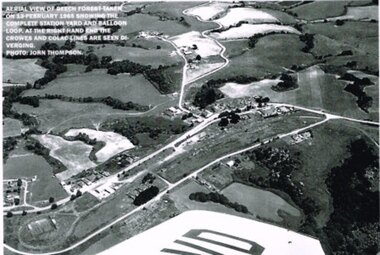
Photograph, R. Preston, Aerial view: Beech Forest, 1965, 13 February 1965
... Aerial view: Beech Forest, 1965....B/W. Aerial view of Beech Forest showing the complete...; B/W. Aerial view of Beech Forest showing the complete ...B/W. Aerial view of Beech Forest showing the complete station yard including the balloon loop (incorporating the two tennis courts), two ex-departmental residences, the station building and where the Colac and Crowes lines diverged. As well Beech Forest Hall, council offices and Shire Secretary's house, Denherts Track, and Main Road are shown.beech forest; railways; township; aerial; -
 Port Melbourne Historical & Preservation Society
Photograph - Aerial view, The Boulevard Upgrade Sandridge Beach, Oct 2003
... Aerial view...Shows an aerial photographic view of Garden City with five... Phillip. Shows an aerial photographic view of Garden City ...Shows an aerial photographic view of Garden City with five smaller pictures of different locations relevant to the upgrade of the boulevard.Existing conditions the Boulevard Upgrade Sandridge Beach 1:500 October 2003 City of Port Phillip.local government - city of port phillip, fred jackson reserve, advertising, perce white reserve, frederick charles jackson, perce mcguire white, perce white -
 Melbourne Legacy
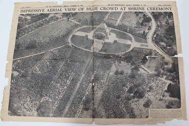
Newspaper - Article, Impressive aerial view of huge crowd at Shrine ceremony, 1934
... Impressive aerial view of huge crowd at Shrine ceremony.... This aerial view of the vast crows was taken as the Duke and his... of dedication performed by the Duke of Gloucester. This aerial view ...A newspaper cutting from 1934 showing the crowd at the opening ceremony of the Shrine of Remembrance. The Shrine was officially opened by the Duke of Gloucester. The caption says 'Marshalled at the Shrine in hundreds of thousands, troops of all arms and services returned soldiers of Australian, British and Dominion units, and a countless mass of citizens, yesterday witnessed the ceremony of dedication performed by the Duke of Gloucester. This aerial view of the vast crows was taken as the Duke and his escort arrived at the southern steps.Early legatees fought hard to have the Shrine of Remembrance accepted as the preferred form of commemoration of the first World War. Early legatees would have been at this ceremony and kept this clipping as a memento.Double page spread in The Sun News-pictorial newspaper on 12 November 1934 after the opening of the Shrine.shrine of remembrance, wreath laying ceremony -
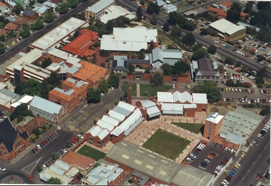
Federation University Historical Collection
Photograph - Photograph - Black and White, N.L. Harvey & Sons Photographers, Ballarat School of Mines Aerial View
... Ballarat School of Mines Aerial View...Aerial view of the Ballarat School of Mines campus from...' junior technical school Aerial view of the Ballarat School ...The Ballarat School of Mines Campus is a campus of Federation University Australia.Aerial view of the Ballarat School of Mines campus from the Grant Stret/Eyre Street corner. The photograph was taken after the demolition of the gaol and before the E.J. Tippett Library and Hillman Recreation Reserve were built. The Ballarat Girls' Technical School is present in Grant Street, and in sthe Ballarat SChool of Mines Mining Laboratory in Albert Street. The Ballarat Brewery (then Carton and United Breweries) is present in Lydiard Street South.aerial, ballarat school of mines, ballarat gaol, ballarat school of mines tennis court, grant street, ballarat girls' junior technical school -
 Stawell Historical Society Inc
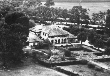
Photograph, “Warranooke” Homestead in Glenorchy 1867 -- aerial view
... “Warranooke” Homestead in Glenorchy 1867 -- aerial view...Aerial View of “Warranooke” Homestead. “Warranooke...Aerial View of “Warranooke” Homestead. “Warranooke ...Aerial View of “Warranooke” Homestead. “Warranooke” Homestead built 1867 enlarged 1926. Shows extensive gardens at front. A very early property in our district Warranooke The main names associated with the property Ayrey - Darnell - Nicoll, later Campbell. Mrs. Campbell built Charles Ayrey's daughter. The Campbells built up the station buildings. The homestead was virtually rebuilt in brick, making it one of the largest and most elaborate in the East Wimmera. Warranooke homestead built 1867, enlarged 1926 destroyed by fire 13th Feb. 1979.Black and white aerial photograph of building showing landscape around the homestead. The photo is on a card with some gold decorations.glenorchy -
Port Melbourne Historical & Preservation Society
Photograph - Aerial view of J Kitchen & Sons site, Port Melbourne, 21 Mar 1939
... Aerial view of J Kitchen & Sons site, Port Melbourne... on buildings) "Aerial view looking East. This view shows the two main...) "Aerial view looking East. This view shows the two main blocks ...Large black and white aerial photo in narrow gold-coloured metal frame of J Kitchen & Sons Pty Ltd factory with Woodruff St in foreground (Electric candles, pure Velvet Soap,and full company name on buildings) "Aerial view looking East. This view shows the two main blocks . 21/3/39" - printed below photo (copy of original)industry - manufacturing, built environment - industrial, j kitchen & sons pty ltd, pental products pty ltd, symex holdings ltd -
 Lake Bolac & District Historical Society
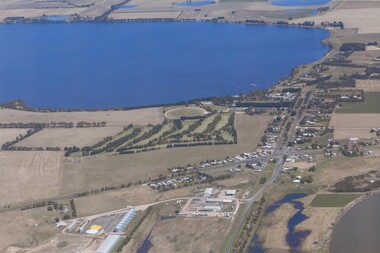
Colour photograph, Aerial view of Lake Bolac and village. After the rain, 2010
... Aerial view of Lake Bolac and village. After the rain...Aerial view of Lake Bolac after the drought had broken... Highway Lake Bolac grampians Aerial view of Lake Bolac after ...Aerial view of Lake Bolac after the drought had broken in late 2010. The fresh-water lake is now full, as are the wetlands. Note the edge of the salt-lake in the bottom right, the Industrial Estate bottom left and centre, the golf course, the current footy oval, Bowling Club, tennis courts and swimming pool with the P-12 College through the trees on the bank of the lake. An Archaeologist might be able to discern the original footy oval bottom centre, built on what was once the town Common (below the industrial buildings),and the second oval (above the salt lake.) The houses are spreading along the west bank of the lake beyond the school.lake bolac, 2010, village, fresh-water lake, salt lake, golf, tennis, bowling, swimming, college, -
Port Melbourne Historical & Preservation Society
Photograph - Aerial view of J Kitchen & Sons site, Port Melbourne, C D Pratt Airview, 21 Mar 1939
... Aerial view of J Kitchen & Sons site, Port Melbourne... Kitchen & Sons Pty Ltd. On back "Aerial view looking North East... & La...' Photograph Aerial view of J Kitchen & Sons site, Port ...COPYRIGHT C D PRATT Black and white photograph of J Kitchen & Sons Pty Ltd. On back "Aerial view looking North East, 21st March 1939". Signs on three middle buildings 'J Kitchen & Sons Pty Ltd'; 'Pure Velvet Soap'; 'Electrine Candles'. Sign 'Australian Box Mills' on building to left "E L Pinkus' on building to Nort east and behind it 'Petersen & La...'"This photo is copyright" and information on owner - C D Pratt 86 McCracken St, Essendonindustry - manufacturing, j kitchen & sons pty ltd, australian box mills, e l pinkus, petersen -
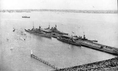 Port Melbourne Historical & Preservation Society
Photograph - Aerial view of HMS Hood (outer east), HMS Repulse (outer west) with escorts Delhi and Danae, Princes Pier, Port Melbourne, Mar 1924
... Aerial view of HMS Hood (outer east), HMS Repulse (outer...(1) Aerial photographic view of Princes Pier with units... repulse hms delhi hms danae (1) Aerial photographic view ...(1) Aerial photographic view of Princes Pier with units of the British Navy alongside 17-25 March 1924. principal vessels are the HMS Hood (OE) and HMS Repulse (OW) with escorts Delhi and Danaepiers and wharves - princes pier, armed services - navy, vessels, hms hood, hms repulse, hms delhi, hms danae -
 Lakes Entrance Historical Society
Postcard - Omeo Victoria, H D Bulmer, 1940 c
... Black and white postcard showing an aerial view...Aerial view of Omeo...Hotels Transport Aerial view of Omeo Black and white ...Black and white postcard showing an aerial view of the roads and country surrounding the mining town of Omeo VictoriaAerial view of Omeohotels, transport -
Port Melbourne Historical & Preservation Society
Photograph - Aerial view of the mouth of the Yarra from Williamstown, 2006
... Aerial view of the mouth of the Yarra from Williamstown...B&W aerial photographic view of the mouth of the Yarra... newport power station B&W aerial photographic view of the mouth ...B&W aerial photographic view of the mouth of the Yarra River, taken from above Williamstown and looking east. Greenwich Bay and the cooling water outlet for Newport Power Station in the foreground, the entrance and Webb Dock in the centre, Sandridge Beach and the city upper right.piers and wharves - webb dock, yarra river, garden city, fishermans bend, newport power station -
Port Melbourne Historical & Preservation Society
Photograph - Photocopy, Aerial view over Swallow & Ariell and surrounds, 1950
... Photocopy, Aerial view over Swallow & Ariell and surrounds...Large photocopy of an aerial photo. 1950 view over Swallow... photocopy of an aerial photo. 1950 view over Swallow & Ariell ...Donor was researching property on the corner of Stokes and Graham St, as old timers claim it was "the Nelson Hotel" although there is no record of such in licensing records. Particular building is at upper left of this image.Large photocopy of an aerial photo. 1950 view over Swallow & Ariell and the Counting House shows St Joseph's Catholic Church; Methodist Church on Graham St (no longer there); Nott Street factories. The "Nelson Hotel" partially showing in the upper left corner.built environment - industrial, industry - food, swallow & ariell ltd, religion - anglican (holy trinity), religion - wesleyan methodist church, religion - roman catholic church (st josephs), nelson hotel, frederick thomas derham, built environment - domestic, business and traders - hotels -
Port Melbourne Historical & Preservation Society
Photograph - Photocopy, Aerial view, Swallow & Ariell to infilled Lagoon, 1946
... Photocopy, Aerial view, Swallow & Ariell to infilled Lagoon...Large photocopy of an aerial photo. 1946 view from Swallow... photocopy of an aerial photo. 1946 view from Swallow & Ariell ...Donor was researching property on the corner of Stokes and Graham St, as old timers claim it was "the Nelson Hotel" although there is no record of such in licensing records. Particular building is at upper left of this image.Large photocopy of an aerial photo. 1946 view from Swallow & Ariell to the infilled lagoon and HMAS Barracks. Poor quality image but shows St Joseph's Catholic Church; Holy Trinity; Edwards Park; Lady Forster Kindergarten; Methodist Church on Graham St (no longer there), Bay St. ; three storey Derham houses built environment - industrial, industry - food, swallow & ariell ltd, religion - anglican (holy trinity), religion - wesleyan methodist church, religion - roman catholic church (st josephs), nelson hotel, frederick thomas derham, built environment - domestic, business and traders - hotels -
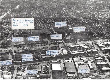
 Federation University Historical Collection
Photograph - Photograph - Colour, Aerial Views of Sites Relating to the University of Ballarat, c1998
... ballarat aerial view... with Federation University Australia. .1 & .2) Aerial views of the State... ballarat aerial view ballarat school of mines aerial aerial brewery ...The Ballarat Technology Park is associated with Federation University Australia. Five colour aerial photographs of sites associated with Federation University Australia. .1 & .2) Aerial views of the State Data Centre, Ballarat Technology Park .3) Aerial view of Mt Helen Campus, c1990 .4 and .5) Aerial View of Ballarat School of Mines Campus, 1998ballarat technology park, state region data centre, ballarat aerial view, ballarat school of mines aerial, aerial, brewery building, ballarat uniting church, albert street -
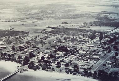
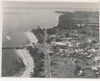 Phillip Island and District Historical Society Inc.
Photograph, Payens' Photographic Services, 1950's
... aerial view cowes phillip island...Black & White aerial view of Cowes township, foreshore... aerial view of Cowes township, foreshore and jetty. Photograph ...Photograph donated by Jean Bain.Black & White aerial view of Cowes township, foreshore and jetty.aerial view cowes phillip island, cowes phillip island -
Phillip Island and District Historical Society Inc.
Photograph, ?
... aerial view cowes...Sepia Postcard - Valentine Series - Aerial view of Cowes... sepia photograph jack jenner aerial view cowes valentine series ...Part of collection of Photographs donated to the Museum by The Family of late Mr. Jack Jenner (1977).Sepia Postcard - Valentine Series - Aerial view of Cowes & Pier.View of Cowes, Phillip Island, from the air. Valentine Series No. 1616.local history, photography, photographs, slides, film, view cowes, sepia photograph, jack jenner, aerial view cowes, valentine series -
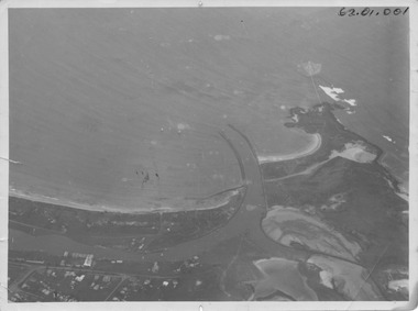 Port Fairy Historical Society Museum and Archives
Photograph, R.W.Golding, 1925
... aerial view...Black and White aerial view of Port Fairy ‘s waterways... Aerial-Port Fairy Harbour 1925 aerial view harbour griffiths ...taken in 1925 by W Golding Aerial-Port Fairy Harbour 1925Black and White aerial view of Port Fairy ‘s waterways62.01.001 on front of photograph - on the back-Port Fairy Moyne River Entrance W Goldingaerial view, harbour, griffiths island, w.golding, training walls -
 Phillip Island and District Historical Society Inc.
Photograph, 1940's 1950's
... aerial view of cowes...Black & White aerial view of the Cowes Township and jetty... cowes phillip island aerial view of cowes cowes jetty cowes pier ...Photograph donated by John JanssonBlack & White aerial view of the Cowes Township and jetty area, Phillip Islandcowes phillip island, aerial view of cowes, cowes jetty, cowes pier phillip island, john jansson -
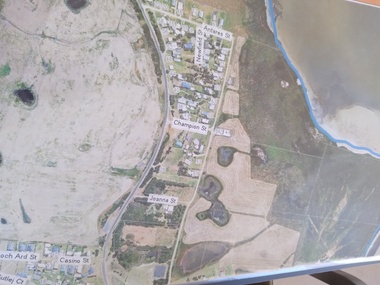 Peterborough History Group
Plan - Moyne Shire Council Aerial photograph, Department of Sustainability and Environment, January 2018
... aerial view...A3 size copy of an aerial view of the majority of the town... peterborough aerial view A3 size copy of an aerial view of the majority ...View shows development at the time and showing the town boundary using Vicmap InformationSignificant in that it provides a record of the current state of development of the town. Also, a view of the estuary at that time.A3 size copy of an aerial view of the majority of the town with street names mentioned. curdies river inlet, peterborough, aerial view -
Glenelg Shire Council Cultural Collection
Postcard - Postcard - Nelson, Victoria, n.d
... Coloured photo postcard, aerial view of Nelson, Victoria...Back: Maker details. 'Aerial view of Nelson Victoria'...: Maker details. 'Aerial view of Nelson Victoria' Coloured photo ...Coloured photo postcard, aerial view of Nelson, Victoria, showing the bridge, township and river mouth. Rose Series De Luxe colorview NO 1213Back: Maker details. 'Aerial view of Nelson Victoria'postcard, nelson -
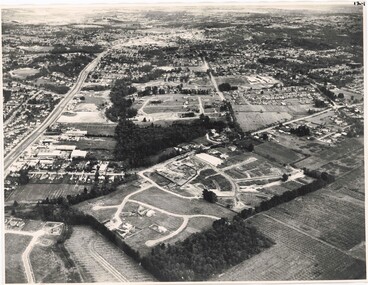 Ringwood and District Historical Society
Photograph, Aerial View of Ringwood, Victoria - circa 1970
... Aerial View of Ringwood, Victoria - circa 1970.... Aerial View of Ringwood, Victoria - circa 1970 Photograph ...Black & white west-facing view over Oban Road along Mullum Mullum Road and Creek. Foreground showing early subdivision development of "Dunn's Orchard Estate" with formation of Frederic Drive (named after the orchardist - Frederic Dunn), Baron Court, Towerhill Drive, Tyson Court, Adele Court, Marilyn Crescent, Abbey Court, Highland Boulevard, Ailsa Court. -
 Ringwood and District Historical Society
Photograph, Aerial view of Ringwood -1972
... Aerial view of Ringwood -1972... photograph Aerial view of Ringwood -1972 Photograph ...Black and white aerial photographSimilar photograph -Reg 926 located in NWD 02-09-07 - Item no G0033 -
Federation University Historical Collection
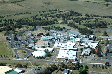
Photograph, Aerial View of the Mount Helen Campus
... Aerial View of the Mount Helen Campus... E.J. Barker Library (top floor) Mount Helen goldfields Aerial ... -
Federation University Historical Collection
Photograph, Aerial View of the Ballarat College of Advanced Education, 1986
... Aerial View of the Ballarat College of Advanced Education... Helen Campus Aerial View of the Ballarat College of Advanced ...Black and white photograph of the Mount Helen Campusmount helen campus, ballarat college of advanced education, aerial photograph, student residences -
Federation University Historical Collection
Photograph, Aerial View of Mount Helen Campus
... Aerial View of Mount Helen Campus... Campus Aerial View of Mount Helen Campus Photograph ...Two aerial viewls of Mount Helen Campusaerial, mount helen campus, buildings -
 Federation University Historical Collection
Photograph, Aerial View of Gippsland Campus, 2004
... Aerial View of Gippsland Campus... era as a campus of Monash University. Aerial View of Gippsland ...In 1989 Monash University took over the Gippsland Institute of Advanced Education to create Monash Gippsland Campus. In 2014 the University of Ballarat and the Churchill Campus of Monash University merged to become Federation University Australia.Photograph of the Federation University Gippsland Campus during its era as a campus of Monash University. gippsland campus collection, monash university gippsland campus, churchill, aerial