Showing 15863 items
matching areas
-
 Ringwood RSL Sub-Branch
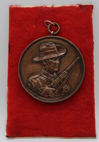
Uniform - South Australian Comfort Funds medallion
Metal medallion service locationsVarious service areas -
 Ringwood RSL Sub-Branch
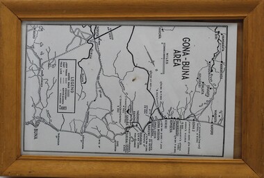
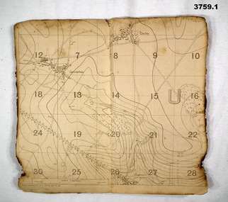
Work on paper - Gona-Buna Area
Gona-Buna Area -
 Hume City Civic Collection
Photograph
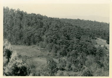
The woodland area was photographed on the outskirts of the old Sunbury township.The landscape featured in this image was typical of Sunbury's surrounds in the 19th and early years of the twentieth century. A copy of a non-digital black and white photograph of an woodland area. Two men with a horse and cart are visible in the image.VIEW OF SUNBURYhorses, drays, trees, c. nettleton -
Greensborough Historical Society
Document, Commonwealth War Graves Commission. [Greensborough area], 1917-1945
A list of residents from the Greensborough area who died on active service and whose graves are recorded on the Commonwealth War Graves Commission website (www.cwgc.org). Includes Greensborough, Watsonia, Lower Plenty, Montmorency, Bundoora and Macleod.2 page printout of names of war dead from the Greensborough area.Hand written on page "For complete details see electronic copy on Victorian collections"commonwealth war graves commission, world war 1, world war 2, greensborough, watsonia, lower plenty, montmorency, bundoora, macleod -
 Vision Australia
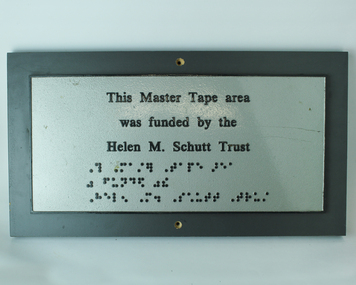
Photograph - Image, Helen M Schutt trust plaque
Commemorative plaque for the funding of the Master Tape area by the Helen M. Schutt Trust. As an audio library, master tapes were created so that titles could be duplicated multiple times. Preserving these master tapes required a temperature controlled environment and minimal dust or dirt.Metal plate attached to wooden plaqueThis Master Tape area was funded by the Helen M. Schutt Trust (followed by brailled version of above)nameplates, royal victorian institute for the blind, association for the blind -
 Marysville & District Historical Society
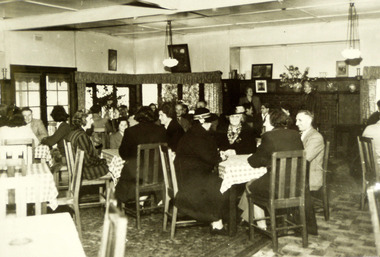
Photograph (Item) - Black and white photograph, Unknown
A black and white photograph of the dining area in The Crossways in Marysville. The Crossways was built in the early 1920s and is the oldest building in Marysville. The Crossways historic inn survived the 2009 Black Saturday bushfires thanks to the efforts of its c-owner Greg Cherry and, in the days after the fires, provided a much-needed refuge to the Marysville community and firefighters. A black and white photograph of the dining area in The Crossways in Marysville.marysville, victoria, australia, photograph, the crossways cabaret, the crossways, crossways, crossways country inn, crossways historic inn, 2009 black saturday bushfires, accommodation -
Phillip Island and District Historical Society Inc.
Tourist leaflet
Leaflet advertising the San Remo Hotel and its amenities with a photograph of the Hotel and a description of the area.Leaflet advertising San Remo Hotel and its amenities with a photograph of the Hotel. Also describes the attractions of the area.local history, documents, commercial, documents, pamphlets, san remo hotel, tourist leaflet, san remo hotel -
 Halls Gap & Grampians Historical Society
Photograph - B/W, C 1960s
This photo was taken in the Mt William area and was material for a Ministry of Tourism campaign.The photo shows a man seated on a rock and looking out over a valley (Mt William area, south west)'This Photograph is with, The Compliments of The . . . ,Ministry of Tourism, Government of Victoria, Please acknowledge, Photo: Michael Chesire' stamped on back. 'Grampians Mt. William' written on back in red pen.scenery, mount william -
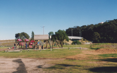 Lakes Entrance Regional Historical Society (operating as Lakes Entrance History Centre & Museum)
Photograph - Apex Park Lakes Entrance Victoria, 2000 c
Apex Park showing new adventure playground and barbeque area, new concrete bridge over North Arm in background Lakes Entrance Victoria. Also a photograph of Apex Park new slides Colour photograph of Apex Park showing new adventure playground and barbeque area, new concrete bridge over North Arm in background Lakes Entrance Victoria. Plus 2 other photos of the same area recreational facilities, parks -
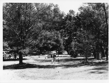 Halls Gap & Grampians Historical Society
Photograph - B/W, C 1960s (?)
This is a photo of Zumsteins picnic area (before the pine trees were removed).The photo shows a woman walking in a picnic area, holding the hand of a toddler and a little girl. On the far left a person is sitting at a picnic table under a tree. A Vauxhall car is parked beside the table. The area has a large number of trees, some of which are non-native pine trees.scenery, zumsteins -
 8th/13th Victorian Mounted Rifles Regimental Collection
Photograph
The extensive stock routes of the Booligal area made a good training area for a reconnaissance squadron.Black and white photograph of Private Roche, A Squadron 8/13 Victorian Mounted Rifles at wheel of Land Rover during annual exercise in Booligal area 1983. -
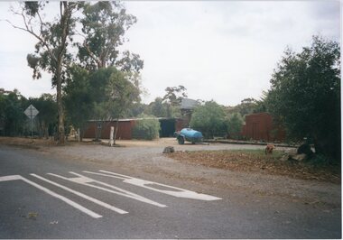 Stawell Historical Society Inc
Photograph, Don Rickard, Cobb & Co Staging Area, Armstrong, c1990's
Cobb & Co Staging Area Armstrong next to Post Office, Low Building is site of Stables Since Rebuilt (Storm Damage) and clad in Flattened Steel Sheets.Colour photograph of Staging Area next to Post Office, Partly Hidden Behind trees -
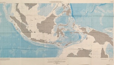 Federation University Historical Collection
Map - Geological, U.S. Government Printing Office, Bathymetric Map of the Indonesian Region: Folio of the Indonesian Region Map I-875-A, 1974, 1974
Map was prepared on behalf of the Government of Indonesia, The United Nations Economic Commission for Asia and the Far East, the Agency for International Development and the U.S. Department of State in cooperation with the Geological Survey of Indonesia. The area covered shows the islands and seas from Latitude 12 degree North to 16 degrees South and Longitude 90 degrees to 148 degrees. Various water features are also named.Large map showing the Indonesian area - islands and seasLongitude and Latitude are shown. Major / Capitol cities indicated. Names of those responsible for the productionindonesia, united nations economic commission, department of state, geological survey, latitude, longitude, government of indonesia -
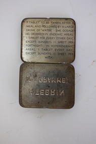 Dandenong/Cranbourne RSL Sub Branch
Atebrin Container
Atebrin was an anti-malarial supplied to Australian forces for use in tropical areas in WWII and Vietnam.This tin is representative of the experience of Australian service personnel serving in tropical areas throughout the 20th Century.Small green rectangular tin container. Embossed writing on the bottom. Hinged lid. Text inside the lid explaining the use of the contents. The tin is empty.ATEBRIN / (0.1 GRAMME) Tablet to be taken after a meal and followed by a large drink of water. The dosage (as ordered) in endemic areas, 1 tablet for every other day, except sundays (1 sheet per fortnight); in hyperendemic areas, 1 tablet every day, except sundays (1 sheet per week).malaria, atebrin, wwii, vietnam, medicine, treatment, tropical, new guinea, aif -
 Surrey Hills Historical Society Collection
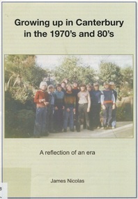
Book, Growing up in Canterbury in the 1970s and 80s:a reflection of an era, 2015
This is a recollection of what was one person's view on growing up in Willandra Avenue, Canterbury and the surrounding area.This is a recollection of what was one person's view on growing up in Willandra Avenue, Canterbury and the surrounding area.|20 pages(mr) james nicolas, childhood and youth, canterbury, willandra avenue, scouts, (mrs) betty ballantyne, (mr) - hawkens, (mrs) - hawkens, (mrs) - thomas, (mr) phillip anderson, kranjcics family, (mr) john proper, (dr) (mr) - barton, (mr) - phillips, (mr) - goff, (mrs) - mcmillan, (mr) - mceroy, (miss) caroline harris, (mr) - ielpo, (mr) graeme brent, (mr) peter brent, (mrs) tuyet brent, buckingham family, (mrs) - proper, billings family, howats family, canterbury football club, (mr) jim shepherd, (mrs) lillian shepherd, tulloch begg, house names, salvation army, (mr) (dr) alan williams, dentists, doctors, malone's hotel, canterbury mansions, (mr)(father) - potter, (mrs) - kerr, (mr) - kerr, canterbury cricket club, the gunyah, (mr) jim richards, (mr) "rainbow" simpson, canterbury football club, (mr)(cr) - maling, (sir) (mr) aaron danks, logan family, hasset family, staig family, (mr) tony petroro, outer circle, canterbury presbyterian church, bradshaw's mechanic, (mr) francis bourke, emulation hall, (mr) - cameron, (mr) - lathan, canterbury primary school, vozzo's milk bar, camberwell high school, (mr) - de munk, (mr) - howie, (miss) - patterson, (mr) - collins, (miss) kylie minogue, (mr) craig mcdonnell, (mr) dean mcdonnell, (miss) danni minogue, (mr) jack) morris, (mrs) marjorie rowe, (mr) andrew rowe, (mr) peter rowe, (mr) richard rowe, (mr) richard rowe, (mr) frank kelly, gagliardi family, (mr) phillip graham, mcdonnell family, sutherland family, toddle inn, rooney's butcher -
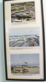 National Vietnam Veterans Museum (NVVM)
Photograph, (1962 - 1973)
3 Coloured photos in black frame. 1. View of Facilities - Peter Badcoe Club / Pool 2. View - AOD - Looking along Beach Road. 3.Huey leaving vampire pad - RAASC vehicle Area1. View of Facilities - Peter Badcoe Club / Pool 2. View - AOD - Looking along Beach Road. 3.Huey leaving vampire pad - RAASC vehicle Areapeter badcoe club (vung tau, vietnam), hueycobra (helicopter), photograph -
Whitehorse Historical Society Inc.
Document, Dear Fethers, 2000
An historical saga, pre-1066 - 1990s.An historical saga, pre-1066 - 1990s. Includes information about the Wakefield and Kefford families, who settled in the Nunawading area.An historical saga, pre-1066 - 1990s. wakefield street nunawading, wakefield, john, kefford, richard, fisher, james cowley morgan -
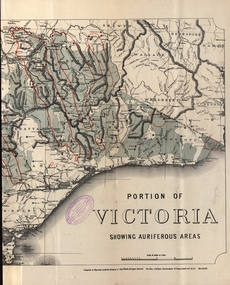 Federation University Historical Collection
Map - Map and Information, Department of Mines: Map and Suggestions to Prospectors, 1891
The map outlines the auriferous (gold bearing) areas in Victoria. The information for prospectors was prepared by the Department of Mines in 1894Document: 4 page type written Map: Portion of Victoria divided into Counties of 1891. Auriferous areas with red.Reference section on mapgold, auriferous areas, department of mines, victoria, map of victoria, prospectors, commissioner of crown lands, hon a mclean, alexander black, surveyor general, a mclean -
 Bendigo Military Museum
Map - TRENCH MAPS WW1, 1918
Areas covered on both, “Villers Brettoneaux, Cachy, Hangard, Gentelles”. Items re William Alexander No 502 AIF. Refer Cat No 3746.3 for his service details.(.1 & .2) Both maps are same area, field survey 24.4.1918, scale 1:20,000.map, trench, france -
 Mt Dandenong & District Historical Society Inc.
Photograph, Site of Jeannie Richardson's Home 1973
John Lundy-Clarke grew up in the Kalorama/Mt Dandenong area and later in life (1972-74) began to write a comprehensive history of the area working from an original settlement map in an effort to cover all areas. It was in the clearing on the left that John William (Willie) Richardson built a home for his wife Jeanie Green. It was called Mount Calvin. Jeanie was often ill and the family left the area seeking a warmer climate. They eventually settled in Brisbane. Willie sold the home and 60 acres around it to W. Rowse. Jeanie died in 1916. The remainder of the land was sold by solicitors to cover debts. Black and white photograph showing a treed hillside with a cleared area to the left hand side. Handwritten inscription on reverse by John Lundy-ClarkeLooking towards the site of Jeannie's home from near Doughty’s Road Nov 1973. Her house was in the centre of the clearing on the left. Photo Jan 1974 JLC.mount calvin, jeannie richardson, jeanie green, john william richardson, willie richardson, jeanie richardson, rowse -
 Sunbury Family History and Heritage Society Inc.
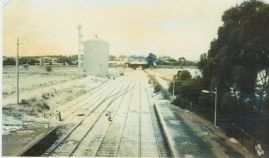
Photograph, 25th July 1986
Heavy snow fell across Melbourne and surrounding suburbs, including Sunbury, on 25th July 1985. The photograph taken from the pedestrian bridge at Sunbury Railway Station is looking north to the historic Macedon Street bridge. The widespread snow across the metropolitan area on that day caused much chaos.A coloured photograph of widespread snow across a railway line and the surrounding area.sunbury railway station, extreme weather events, snow storms -
Whitehorse Historical Society Inc.
Document, Petticoat parliament, 2008?
Petticoat parliament: collecting the signatures.Petticoat parliament: collecting the signatures. Poster about the 140 signatures to the 1891 Women's Suffrage Petition collected in the Whitehorse area.Petticoat parliament: collecting the signatures. women's suffrage petition 1891, signatures -
Whitehorse Historical Society Inc.
Document, Centenary of Women's Suffrage, 2008
A List of Petition signatories 1891.A List of Petition signatories 1891. Also first female parliamentarians, mayors and councillors in the Whitehorse area up to 2007 are featured.A List of Petition signatories 1891.women's suffrage petition 1891, victorian honour roll of women, petitions, mayors, councillors, parliamentarians -
 Kiewa Valley Historical Society
Map / Chart, Vegetation Map & Guide to Alpine Flora: Hotham, 1982
This poster shows Mt Hotham is on the Victorian High Plains. This poster and map enables the comparison to be made of flora in other areas of the Victorian High Plains e.g.. which was previously known as the Bogong High Plains. This poster has historical and research value as it shows the flora in Mt Hotham area therefore making it significant for people interested in plants. Also for those who would like to compare what plants are still in this area after 1982 and if the cattle grazing, climate change, of bush fires have had on the environment. Thus this poster also has good interpretive capacity of these reasons.Laminated double sided vegetation map and photographic guide to Alpine flora of the Hotham area.hotham. vegetation. plants. flowers. alpine. high plains of victoria. -
 Forests Commission Retired Personnel Association (FCRPA)
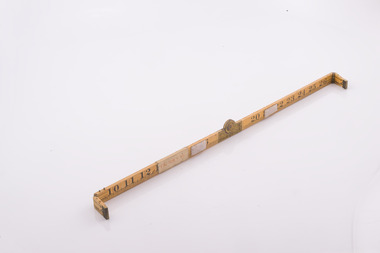
Basal Area Angle Gauge
Foresters usually measure the diameter of trees at Breast Height – traditionally 4 foot, 6 inches – now 1.3 m – which is termed Diameter Breast Height Over Bark (DBHOB). Basal Area is the cross section of the tree trunk at breast height, and the sum for the stand or group of trees is expressed square feet per acre (after 1973 it was expressed in square metres per hectare). Lots of skinny trees, or a few fat ones, can have the same Basal Area, but when combined with the number of stems, Basal Area is a good indicator of stand density. Two common methods are used to measure of Basal Area – fixed area plots and angle count sampling. 1. Fixed area plots require setting out a small area, commonly 50 m x 20 m, and measuring all the trees at breast height, and doing some quick sums. 2. Angle count sampling involves a simple sweep of the forest from a fixed sampling point using a relascope, dendrometer sight, angle gauge, or glass wedge prism. This wooden builders ruler has been shaped at one end to create a shallow angle (usually less than 3 degrees). Standing in one spot, a sweep is made with the wedge held to the eye, and trees are counted as either “in” or “out”. The number of trees is multiplied by conversion factor of the wedge (10 in this case) to estimate basal area. It’s very quick and effective.Basal Area Angle Gauge The two ends fold up and one end (on the right) has been reduced in width to create a shallow angle for the viewer Home made by cutting down a wooden builder's ruler Many forestry students made their own Basal Area Angle Gauges and its thought this may be oneforest measurement, forests commission victoria (fcv) -
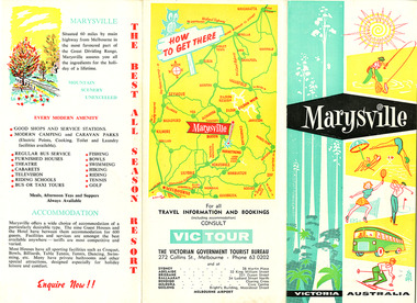 Marysville & District Historical Society
Ephemera (Item) - Tourist brochure, Victorian Government Tourist Bureau, Marysville Victoria Australia, Unknown
A tourist brochure on Marysville and the surrounding area published by the Victorian Government Tourist Bureau for the Marysville Tourist and Progress Association.A tourist brochure on Marysville and the surrounding area published by the Victorian Government Tourist Bureau for the Marysville Tourist and Progress Association.marysville, victoria, tourist brochure, victorian government tourist bureau, cumberland valley, cumberland falls, cora-lyn falls, robart's lookout, meeting of the waters, warburton, acheron way, healesville, launching place, reefton spur, upper yarra dam, maroondah highway, black spur, maroondah dam, alexandra, mansfield, jamieson, wood's point, eildon weir, snob's creek, rubicon, lake mountain, marysville tourist and progress association, the cumberland, kerami guest house, kooringa guest house, marylands guest house, marylyn guesthouse, marysville hotel, mount kitchener house, barton brothers' store, fruit salad farm, marysville dairy, marysville caravan park, marysville garage, marysville riding school, marysville theatre, mckenzie's tourist services, potters fruit and milk bar, arosa holiday cottages, scenic motel, beauty spot walk, red hill walk, wishing well, taggerty river, mount gordon, steavenson falls, keppel's lookout, keppel's falls -
Marysville & District Historical Society
Ephemera (Item) - Information brochure, Artworkz Tourism, MARYSVILLE-ANDERSON MILL CAMP AREA, 26-03-2016
An information brochure on the Anderson Mill camp area near Marysville. This brochure was produced by Artworkz Tourism in March 2016.An information brochure on the Anderson Mill camp area near Marysville.Disclaimer: The authors have taken care to ensure this/ publication is correct, though please be aware that/ errors and omissions do occur.marysville, victoria, australia, information brochure, artworkz tourism, anderson mill camp area, anderson mill -
Marysville & District Historical Society
Ephemera (Item) - Information brochure, Artworkz Tourism, MARYSVILLE-KEPPEL CREEK CAMP AREA, 26-03-2016
An information brochure on the Keppel Creek camp area near Marysville. This brochure was produced by Artworkz Tourism in March 2016.An information brochure on the Keppel Creek camp area near Marysville.Disclaimer: The authors have taken care to ensure this/ publication is correct, though please be aware that/ errors and omissions do occur.marysville, victoria, australia, information brochure, artworkz tourism, keppel creek camp area, keppel creek day visitor area -
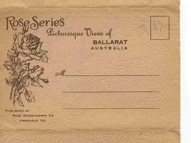 Ballarat Tramway Museum
Postcard - Folder set, Rose Stereograph Co, "Rose Series Picturesque Views of Ballarat Australia", c1940
Set of 12 views of Ballarat printed with six photos on either side of a folded strip of paper contained within a heavy brown paper folder. Published by the Rose Stereograph Co. of Armadale Vic., titled "Rose Series Picturesque Views of Ballarat Australia". Front cover has address area, stamp position, a drawing of roses and publishers details. 1. "The Town Hall and Sturt St. " with two trams eastbound in Sturt St. The first tram is a Sebastopol type tramcar. (see image 4) 2. "Eureka Memorial" 3. "The Conservatory" 4. "The gardens and Town Hall, Sturt Street" 5. "Panorama of " Sturt St. from Town hall, looking east 6. "Avenue of Honour Arch" 7. "The Flight from Pompeii - The Gardens" statue 8. "Bridge Street" - showing an SEC single truck tram in the street (see image 5) 9. "The Statuary Pavilion, Botanical Gardens" 10. "Sturt St." 11. "Lake Wendouree" 12. "Sturt St." (from Grenville St.) - with two ESCo trams in photograph (see image 6) (See also Reg. Item 2268 for a single postcard using this image.) All have words "Ballarat Vic." after the caption. Images 1 of front cover, 2 and 3 are of the object itself. Date of photos seem to be varied over time from early 1930's through to 1940's given the different motor cars in the photographs. On front cover in pencil in stamp area "G $7-"trams, tramways, ballarat, rose postcards, sturt st, bridge st, gardens, esco