Showing 8323 items
matching bridging
-
 Port of Echuca
Photograph, Original photo C.1910. Copy 1984
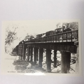
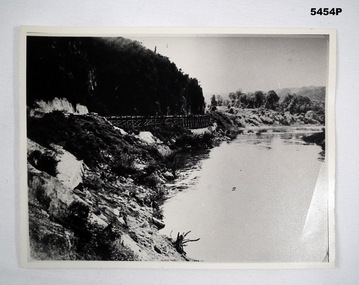
This photograph comes from the Dowell collection. Related to P000202. At the turn of the 20th century, the railway line carried produce from southern New South Wales and the Riverina to Melbourne. Goods trains were a very important mode to transport to our region and industrialisation of Echuca. Photograph of the Murray bridge at Echuca at low river with a goods train crossing the bridge. Image is seen from bank facing north from Echuca.Recto :"MURRAY BRIDGE Echuca"; Verso: "C.1910" "Low river"dowell collection, murray river bridge , echuca, murray bridge, echuca, steam engine goods train, railway, transportation, industrialisation -
 Clunes Museum
Photograph, 1939
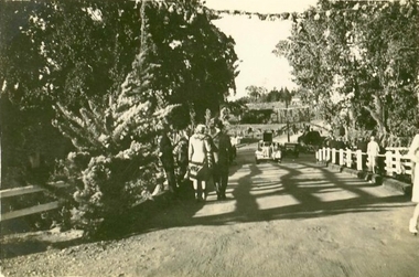
THIS PHOTOGRAPH WAS TAKEN DURING EASTER CENTENARY CELEBRATIONS 1939ORIGINAL PHOTOGRAPH OF BUTTER FACTORY & BRIDGE OVER CREEK.BRIDGE OVER CREEK, PHOTOGRAPH TAKEN FACING TOWARDS THE PARK.local history, photography, photographs, bridges -
 Clunes Museum
Photograph
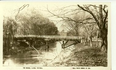
SEPIA COPY PHOTOGRAPH OF JUBILEE OR QUEEN'S BRIDGE, CLUNES.THE BRIDGE, CLUNES, VICTORIA. REAL PHOTO SERIES M 2155local history, photography, photographs, bridges -
 Marysville & District Historical Society
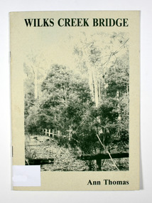
Book, Wilks Creek Bridge, 1993
A history of the Wilks Creek Bridge and its connection to the Yarra TrackPaperback. Front cover has an old photograph of the Wilks Creek Bridge.Dear Reader, The pen has only to select one of the many stages of building old Yarra Track,/ for a colorful story subject. The Track, first established in the early 1860's to/ serve goldseekers making their hazardous way to the rich Wood's Point goldfields,/ extended some 160km from Eltham - in Melbourne's northern region to Woods/ Point in the eastern ranges. I hope a glimmer of the excitement of those times comes through as I draw/ your attention to old Wilks Creek bridge and its picnic spot to be found 3.5km/ west of Marysville. Once part of Yarra Track and now superseded by a modern/ roadway alongside, the old bridge with its solid masonry walls either side of the/ cold, pure stream makes a pleasing scene for the visitor. With much pleasure/ I dedicate this narrative to Marysville and District Historical Society./ Ann Thomas Stamp of Marysville & District / Historical Society Inc / P.O. Box 22 / Marysville 3779wilks creek, marysville, yarra track, victoria, history, local history -
 Bendigo Military Museum
Photograph - PHOTOGRAPH, WAMPO BRIDGE, C1943-1948
REFER TO CAT 5445.2Photograph black and white. River, jungle covered hills. In the centre of the photo is a rail trestle bridge set against the steep hillside. The trestle bridge is made from timber On the rear of the photograph in ink. - 122326 WAMPO BRIDGE THAILAND- BURMARAILWAYww2, pow, burma railway -
 Robin Boyd Foundation
Slide, Robin Boyd, 1950
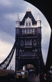
Penleigh Boyd, Robin and Patricia Boyd's son, writes “Prior to 1950 Robin, like most other amateur or hobby photographers, took black and white printed photographs. The oldest slides date from 1950 when Robin and Patricia travelled to Europe on Robin’s Robert Haddon Travelling Scholarship.” In 1948 Robin Boyd was awarded ‘joint first place’ in the Robert Haddon competition for his design of Mildura art gallery. The scholarship helped fund their first overseas trip. Robin and Patricia were passengers on the Greek ship “Cyrenia” departing in May 1950, passing through the Suez Canal and landing in Genoa five weeks later. For six months, they travelled extensively throughout Europe (predominantly driving themselves) - France, Italy, United Kingdom, Sweden, Denmark, Germany, Austria, Switzerland and Spain.Colour slide in a mount. Tower Bridge (1894), London, England . (Architects: Horace Jones, George Gilbertson.)London Bridge / Towerbridge (All Handwritten)haddon travelling scholarship, haddon, robin boyd, slide -
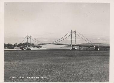
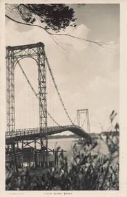
 Phillip Island and District Historical Society Inc.
Photograph, Country Roads Board, 1960's
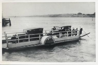
Nine photographs from the Country Roads Boards with Negative Numbers and description. Donated by L. J. HaywardNine photographs of the 2 car Punt and the 2 bridges between San Remo and Phillip Island. 310-01. Photograph of the two car punt operating in 1929 between San Remo and Newhaven. 310-02. Photograph of the Suspension Bridge between San Remo and Newhaven. 310-03. Photograph of the two bridges - old and new. 310-04. Photograph of the construction of the new bridge. 310-05 to 09. Photographs of the construction of the new bridge.310-01. CRB Neg No 68-1091 310-02. CRB Vic. Aust. Neg No. 61-864C 310.03. CRB Neg No. 69-1406 310-04. CRB Neg No. 67-3741 Phillip Island Bridge Sheet Pile Coffer Dam. 310-05. CRB Neg No. 68-461A. Phillip Island Bridge Portal Frame Piers on San Remo side. 310-06. CRB Neg No. 66-1012B Phillip island Bridge. The temporary steel bridge in October 1966. 310-07. CRB Neg No. 67-4019C Phillip Island Bridge. Anchor span beam 204 ft long. 310-08. CRB Neg No. 67-1826E. Phillip Island Bridge. Stressing an anchor span beam. 310-09. CRB Neg No. 67-1930F. Phillip Island Bridge. Placing the first beam on No. 3. span.suspension bridge, phillip island bridge, newhaven-san remo punt, l j hayward -
 Phillip Island and District Historical Society Inc.
Photograph
Part of collection of Photographs donated to the Museum by the family of the late Mr. Jack Jenner (1977)Black & White Photograph of Old Bridge from Newhaven.Looking toward Old Bridge from Newhaven. 1-12-1969local history, photography, photographs, slides, film, view from newhaven, black & white photograph, jack jenner, bridges, newhaven, san remo -
 Ballarat Heritage Services
Photograph - Photograph - Colour, Clare Gervasoni, Nimon's Bridge, 1999, 04/10/1999
Nimons Bridge was built in 1890, as part of the then Ballarat-Linton railway. The bridge is 17 spans with tall timber piers of four driven piles each, with triple sets of diagonal cross-bracing and walers and a single row of longitudinal horizontal bracing between piers. The spans are of a uniform twenty feet (6.1 metres), originally supported by four 21-inch x 9-inch (535 mm x 230 mm) Kauri timber beams per span, following the standard V.R. design of the period. When the superstructure was rebuilt after the 1953 fire, the timber beams were replaced with two 24-inch (610mm) deep rolled-steel-joists on each span. These are marked 'Lancashire Steel Co., Scotland' and are believed to have been second-hand. The deck of transverse-timber planks is 103.6 metres in length. Overall the bridge has an impressive appearance with its exceptionally tall triple-cross-braced piers creating a 'three-tiered' effect, with the deck 19.2 metres above the Woady Yaloak River. The Ballarat-Skipton line closed in 1985. Nimons Bridge has been recently restored, as part of the Ballarat-Skipton Rail Trail. How is it significant? Nimons Bridge is significant for technical, historic and aesthetic reasons at a State level. Why is it significant? Nimons Bridge is technically significant as Victoria's fourth-tallest timber trestle bridge when built, and as the third-tallest surviving example. It is also the second-largest composite bridge combining traditional timber piers with RSJ spans and a timber deck and falls within a select group of fewer than ten timber railway bridges with horizontal longitudinal bracing between the piers and three sets of double cross-bracing on its tallest piers, creating a visually striking 'three tiered' effect that enhances its viaduct form. Nimons Bridge is historically significant as having served initially the mining community at Linton, then the Western District agricultural area and in later years a kaolin quarry at Pittong. Nimons Bridge is historically significant as a representative of the 'light' branch line methodology that stimulated the explosion of railway construction in Victoria during the 1880s, and provides an interesting contrast with the more solid and vastly more expensive railway viaducts built in similar terrain on Victorian main lines, at Moorabool and Taradale, in the late 1850s. Approached by a deep cutting and high embankment at either end, the bridge represents a very cost-effective late 19th century engineering solution to the characteristic physiography of western Victoria with flat basalt plains intersected by deep wide valleys occasionally subject to severe flooding. Nimons Bridge is aesthetically significant for its visually impressive viaduct form, crossing a deep and steep-sided valley that is part of a rich cultural landscape. Within close proximity of the bridge are mullock dumps, tailings, shaft sites and other relics of the deep-lead alluvial mining era. The bridge is the most visually spectacular timber-trestle rail bridge in Western Victoria and is among the most spectacular timber-trestle rail bridges surviving anywhere in Victoria. It is part of the Ballarat-Skipton Rail Trail. Classified by the National Trust :02/10/2000 (http://vhd.heritagecouncil.vic.gov.au/places/67986)Colour photograph of a log bridge known as Nimon's Bridge.ballarat-linton, nimons bridge, nimon's bridge, log bridge, viaduct, timber-trestle rail bridge -
 Phillip Island and District Historical Society Inc.
Photograph - Post Card, 1940's
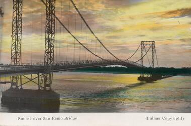
One of 11 photographs left in the museum for the Society by an anonymous donor.Colour postcard of the old Suspension Bridge from San Remo to Newhaven at sunset.Sunset over San Remo Bridge (Bulmer copyright)phillip island suspension bridge, sunset at san remo -
 Port Melbourne Historical & Preservation Society
Photograph - Station Hotel, corner Bridge and Station Streets, Port Melbourne, c. 1950
Black & white photograph of the Station Hotel with Railway reserve & Bridge Street in the foreground.On reverse ' Station Hotel Cnr Bridge & Station Streets'business and traders - hotels, built environment - commercial, built environment - domestic, station hotel -
 Federation University Historical Collection
Photograph, Two black and white photographs at Wentworth
Jack (John R) Watson and Herb (Ernest Herbert) Smith at Wentworth..1 Bridge at Wentworth .2 Loch at Wentworth.1 verso - Bridge at Wentworth .2 verso - Loch at Wentworth Herb and Jackwentworth, bridge - wentworth, loch - wentworth -
 Phillip Island and District Historical Society Inc.
Photograph, 1940's - 1950's
One of a collection of 9 photographs donated by the former Shire of Phillip Island. This photo was part of a pack of postcards sold to the tourists/visitors to Phillip Island.Black & White photograph of view eastward from Cleeland Bight of the Phillip Island/San Remo Suspension Bridge. The photo is part of a set."The Suspension Bridge San Remo"suspension bridge san remo/phillip island, phillip island suspension bridge, bridges, shire of phillip island -
Tatura Irrigation & Wartime Camps Museum
Photograph, Clark D, 1989
Waranga Basin commenced in 1902Black and white photograph of Waranga - Mallee channel, flowing under bridge on Tatura - Rushworth road.on back - Bridge over Waranga - Mallee channelwaranga basin -
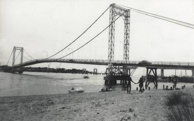
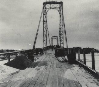 Phillip Island and District Historical Society Inc.
Photograph, Suspension Bridge, 1939 - 40
Suspension Bridge completed in 1940 and opened by Hon. Albert Dunstan MLA, Premier of Victoria. First Phillip Island Bridge under constructionPhillip Island Suspension Bridge taken along length of bridge - under constructionlocal history, photographs, bridges, phillip island - suspension bridge, black & white photograph, jack jenner, phillip island bridges -
 Phillip Island and District Historical Society Inc.
Photograph, Phillip Island Bridges, 1968/9
Shows first Bridge carrying traffic with 1969 Bridge just being constructed. From the Jack Jenner CollectionOld suspension Bridge with New Bridge appearing in background. Speed Boat middle foreground. local history, photographs, civil engineering, bridges, phillip island bridge, black & white photograph, jack jenner collection, phillip island bridges, public construction -
 Kew Historical Society Inc
Photograph - Zig-Zag Bridge, 1924
Henry Beater Christian (1886-1962) , was a descendant of one of the earliest settler families in Kew. Employed at the Kew Asylum as a 'public servant', he was a skilled amateur photographer, photographing numerous scenes in Kew and on his travels around Victoria. The majority of his photographs date from 1916 to 1929. His finest photographs are housed in two photograph albums. Digital copy of a photograph from page 8 of the 47-page photograph album containing 261 gelatinous silver images, loaned by Diane Washfold with permission given to digitise and hold a copy in our collection. The Zig-Zag Bridge linked the grounds of the Yarra Bend and Kew Asylums. The wooden bridge was constructed in the 1870s and lasted through numerous floods until its destruction in 1929. A horizontal structure, the walkway was reached via a wooden staircase on the Kew bank of the river. The steps were required due to the different levels of the banks on this stretch of the river. The photo is taken from the Kew side of the river and shows clearly the width of the walkway on top of the bridge. "Zig-Zag Bridge"henry beater christian (1886-1962), landscape photography, kew (vic.) — yarra river, christian-washfold collection, photograph albums, zig-zag bridge -
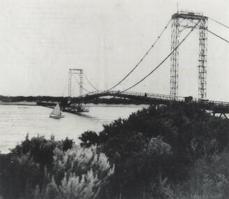 Phillip Island and District Historical Society Inc.
Photograph, Suspension Bridge, 1940's
Phillip Island Suspension Bridge, showing workmen bridge. Bridge completed 1940 and opened by Hon. Albert Dunstan MLA, Premier of Victoria.Phillip Island Suspension Bridge taken from San Remo shoreline with sailing boat underneath and workmen on bridgelocal history, photographs, civil engineering, bridges, phillip island suspension bridge, black & white photograph, jack jenner collection, phillip island bridges, public construction -
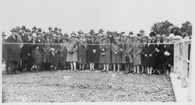 Linton and District Historical Society Inc
Photograph, Opening of Bridge over Woady Yaloak Creek, between Linton and Scarsdale, 1928, 1928
Black and white photograph of a crowd of men, women and children standing behind a ribbon stretched between sets of bridge rails."Opening of bridge between Linton and Scarsdale".events, bridge openings, woady yaloak creek, faull collection -
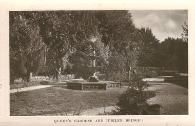 Clunes Museum
Photograph
CLUNES QUEEN'S PARK GARDEN'S.1 ORIGINAL POSTCARD OF CLUNES QUEEN'S GARDEN. FOUNTAIN IN THE FOREGROUND. JUBILEE BRIDGE IN THE BACKGROUND .2 PHOTOCOPY OF POSTCARD .3 ENLARGED PHOTOCOPY OF POSTCARDQUEEN'S GARDENS AND JUBILEE BRIDGE.postcard, queen's park garden -
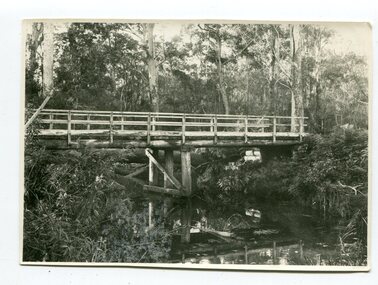 Orbost & District Historical Society
black and white photograph, June 1897
This photograph was taken at what is now the Young’s Creek picnic area which is located on the site of an old sawmill, once owned and operated by L.E. & H. Williams, dating back to the early 1920’s. The mill was eventually sold, dismantled, and the machinery transferred to a sawmill at Cabbage Tree Creek. there are still some items of old sawmill debris. The old steam engine at the edge of the car park is the remains of the mill’s former power plant. This portable steam engine was constructed in Leiston, Suffolk, in England.This is a pictorial record of a popular recreational area in the Orbost district in the late 19th century.A black / white photograph of a wooden bridge over a creek in forest setting. There is a second copy.on back - handwritten "the Young's Creek Bridge June 1897"young's-creek-orbost bridge-young's-creek -
 Phillip Island and District Historical Society Inc.
Photograph - Post Card, A. J. Murray, c 1950
Postcard donated by Brenda HumphreysBlack & White postcard of the Phillip Island Suspension Bridge main span taken from San RemoPhoto Shop Series Phillip Island Bridge.suspention bridge, phillip island suspention bridge, brenda humphreys -
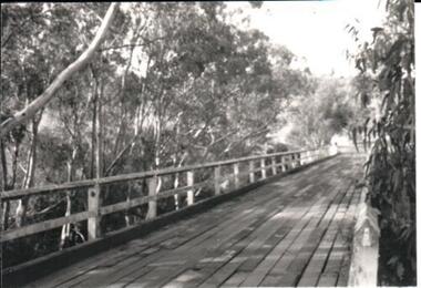 Hume City Civic Collection
Photograph, late 1970s
The photograph was taken before the wooden Holden Bridge which spans an arm of the Deep Creek at Bulla was replaced by a more sunstantial concrete structure. As well as building a new bridge, the sharp bend and approach to the old bridge was also removed.A black and white photograph of a wooden road bridge with eucalypt trees growing on either side of the bridge.bridges, holden bridge, shire of bulla, george evans collection -
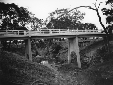 Stawell Historical Society Inc
Photograph, Greens Creek Bridge on the Wimmera River 1929
Greens Creek Bridge on the Wimmera River built in 1929 by C.R.B. and now demolished. The replacement bridge was designed to cope with the floods and the approaches to the new bridge were built up. This photo is a copy of a negative owned by the society.Black and white photograph of a concrete road bridge over a creek. Red gum trees in the background. Two concrete supports remain of old bridge on bank behind new bridge.stawell -
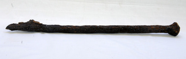 Orbost & District Historical Society
bridge spike
This spike came from the old Brodribb River bridge which is about 9.6 kilometres from Orbost. The Brodribb River joins the Snowy River north of Marlo. In 1906, a bridge replaced the punt over the Brodribb River, improving communication with Orbost. It was eventually replaced by a reinforced concrete bridge built by the Road Construction Authority in 1989 where the Princes Highway passes over the Brodribb RiverThis item belongs to a significant local structure which has been replaced.A very rusty iron bridge spike from the old Brodribb Bridge.brodribb-river bridge-spike -
![The Fairfield Bridge [circa 1891]](/media/collectors/550653872162f11fb04854aa/items/579eab98d0cdd117c4af1c89/item-media/579eac23d0cdd117c4afb1ad/item-fit-380x285.jpg) Kew Historical Society Inc
Kew Historical Society IncPrint, The Fairfield Bridge [circa 1891], c. 1891
This work forms part of the collection assembled by the historian Dorothy Rogers, that was donated to the Kew Historical Society by her son John Rogers in 2015. The manuscripts, photographs, maps, and documents were sourced by her from both family and local collections or produced as references for her print publications. Many were directly used by Rogers in writing ‘Lovely Old Homes of Kew’ (1961) and 'A History of Kew' (1973), or the numerous articles on local history that she produced for suburban newspapers. Most of the photographs in the collection include detailed annotations in her hand. The Rogers Collection provides a comprehensive insight into the working habits of a historian in the 1960s and 1970s. Together it forms the largest privately-donated collection within the archives of the Kew Historical Society.A reproduction of a photograph of the Fairfield Bridge. The bridge was one of the first constructed for the Outer Circle Railway in 1891. Its supervising engineer was [Sir] John Monash. The bridge was later to be repurposed as a road linking the Chandler Highway to Fairfield."Outer Circle Railway Bridge over River Yarra at Fairfield (last section of line opened 1891)"fairfield bridge, chandler highway bridge, dorothy rogers, john monash, outer circle railway -
 Orbost & District Historical Society
black and white photograph, 1918
Tonghi Creek is 66km north - west of Orbost. Prior to the sealing of the Princes Highway west of Orbost, the road surface was anything but good, even by C1917 when cars started to use the road. From Orbost the old road via Marlo to Sydenham was abandoned for the new location which traversed more rugged country via Cabbage Tree, Bell Bird and Club Terrace to Cann River, and the reason for this diversion was on account of settlements being established at Murrungowar and Club Terrace, at which latter place there was a temporary rush to obtain gold. This road was constructed by the Public Works department and a maximum grade of 1 in 19 was adopted, and as speed was not to be catered for the grade followed in and out round the spurs and gullies, resulting in a maze of turns and twists which required a good deal of skill on the part of the horse driver to negotiate." - Bairnsdale Advertiser, Friday, May 2, 1947. (More information from Newsletter February 2010)This item is a pictorial record of roads in the early 20th century in East Gippsland.A large black / white photograph of a bridge over a small creek, surrounded by bush. The photograph is mounted on a thick cream coloured card.on back - "Bridge at Tonghi Creek 1918"tonghi-creek-bridge country-roads-east-gippsland -
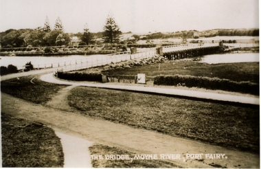 Port Fairy Historical Society Museum and Archives
Postcard, Valentine Publishing Co, The Bridge Moyne River Pt Fairy, 10.04.1929
Black and white Photograph of the bridge crossing the Moyne river with Gipps street in the foreground cleared land in the background taken for use as a postcardThe Bridge Moyne River Pt Fairymoyne bridge circa 1930, bridge, moyne river, river, road -
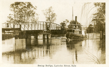 Lakes Entrance Historical Society
Postcard - Bridges, 1925
Note on back dated Christmas 1926Sepia postcard showing steamer Omeo passing through opened swing bridge on Latrobe River at Longford near Sale, Victoria.Swing Bridge, Latrobe River, Saleboats and boating, bridges -
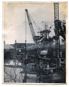 Orbost & District Historical Society
black and white photographs, 1975
These are photographs of the construction of the current cement road bridge across the Snowy River at Orbost. Construction of the bridges commenced in January 1975, with an expectation to open the bridge across the Snowy River as soon as possible. Less than two years later, on 25 November 1976, the bridge across the Snowy River was opened to traffic, allowing the old bridge to be demolished. The remainder of the Orbost Bypass, both the floodplain crossings and the eastern section around the township itself, was declared ‘Princes Freeway’ and opened to traffic in December 1977. (ref http://mrv.ozroads.com.au)The opening of this Snowy River Bridge was an important development in the accessibility to the township of Orbost. These photographs record its construction.Two black / white photographs showing the construction of a road bridge across a river. 3257.1 shows piles being dropped beside the bridge, 3257.2 is of the early stages of construction of this bridge.snowy-river-bridge-orbost road-construction-orbost bridge-orbost