Showing 175 items
matching centennial building
-
 Halls Gap & Grampians Historical Society
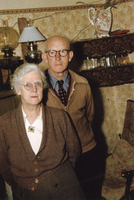
Photograph - Coloured, C 1955-56
The couple are May & David Mitchell in the front room of their holiday shack called "The Holiday Hut" - built by E.C. Mitchell of Stawell at the site of the Borough Huts. See Rec 586 for more information.The photo shows a man and a woman standing in a room. The walls have been papered. A double shelf behind the man has a china jug/vase on the top section and glasses on the lower one. Two lamps stand on the mantle shelf behind the couple. Both people are wearing glasses and the woman is wearing a cardigan with a cream blouse with a brooch. The man is wearing a tie, shirt and zipped cardigan.buildings, houses -
 Halls Gap & Grampians Historical Society
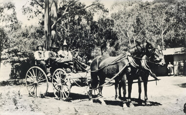
Photograph - B/W, C 1920s ?
c 1920s ? The cottage was known as "Gray's Cottage" and was one of a number in the campground that could be rented for the holidaysPhoto mshows four men in a gig drawn by two horses. A bundle (camping gear) is stowed in front of the gig. A hurricane lamp can be seen on top of the hear in front. On the right a building can be seen, with a woman wearing an apron in the doorway. The building front (presumably the verandah) is weatherboard with the upper half being lattice. Another building (? shed) can be seen vaguely on the left. Large gums and bush are seen in the background.recreation, camping, transport, horse drawn -
 Halls Gap & Grampians Historical Society
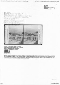
Postcard - B/W, C 1890-1920
This is a Rose's Australia stereocard of Morningside. Built c1875, Morningside was the residence of John and Catherine D'Alton, it was located on site of present (2010) Colonial Motor Inn. c1900 it was owned by Langley family and was taking in paying guests. In 1909 it was leased by James and Grace D'Alton who continued to run a small guest house. In the late 1920's a small building was erected to serve as PO and telephone exchange. C1980 the guest house closed. In 1982 Morningside was demolished.A computer print of a State Library of Victoria Catalogue entry for a stereograph card. The card shows a building, surrounded by trees, standing in large grounds. There is a picket fence with a gate in the foreground and two people leaning on either side of the gate facing each other (as though in conversation). Hills are seen in the background.guesthouses, morningside -
 Halls Gap & Grampians Historical Society
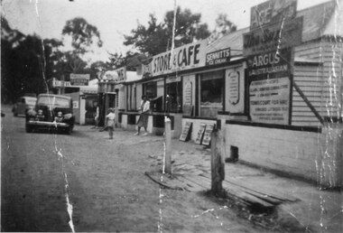
Photograph - B/W
See 'Bridging the Gap' p65. Grampians Road Halls Gap.Group of shops with numerous advertising signs. A woman is leaving a shop, a young girl is standing in front of her. Two cars are parked in front of shops. Gravel road. Large gum trees in the background.buildings, shops -
 Halls Gap & Grampians Historical Society
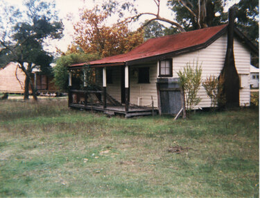
Photograph - Coloured
Originally owned by a Warren family, being the local baker. Warren's daughter, Ida, married Robert Greer, who continued with the bakery until retirement.Side view of cream cottage. Veranda with broken railing. Red iron roof,dark chimney and small 4-paned window on side. small tin fence at side. Autumnal tree in background. Expanse of grass in foreground. Greer's Holiday cottage (rental) c1990's. written in pencil on back.buildings, houses -
 Halls Gap & Grampians Historical Society
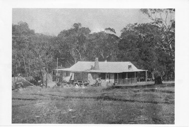
Photograph - Photocopy
This house belonged to Walter Zumstein of the Zumsteins area. The house was burnt down in 1938. Photo was taken by Stan Parfett whose own family camped in the Zumstein area and knew Mr and Mrs Zumstein personally. c1920's This is an photocopied enlargement from a photocopied magazine article, Victoria's Heritage (see item 637)A house with veranda. A chimney (stone?) protrudes from roof at front. cleared land in foreground with old style wooden fence visible. A tank and stand situated beside house at front. Thick trees /Bush behind house.House Burnt 1938. Walter Zumstein's house. Photo by Stan Parfett. written on back.buildings, houses -
 Halls Gap & Grampians Historical Society
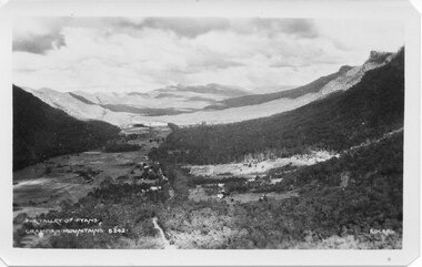
Postcard - B/W
Photo on card was taken by Gilbert Rogers, a photographer and tour guide during the 1930s. This postcard is one of a series.Depicts as valley with mountains on both sides. Cleared land can be seen on either side of a road which runs through the valley. Buildings are also visible in middle area. View is running south-west.scenery, fyans valley -
 Halls Gap & Grampians Historical Society
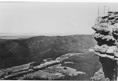
Photograph - B/W, C 1950s (?)
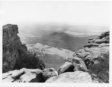
Photograph is of Fyans Valley taken from Bellfield Peak. The mountain range across the centre of the scene runs north to south. The large dwelling centre-front is Bellfield Hotel, which was destroyed by fire in the 1960s. The main road running through the middle of the valley is Grampians Road.A rocky outcrop, far right, with metal fence and posts. View of a valley with cleared land, roads and buildings in foreground. Further cleared land can be seen beyond a mountain range that is in the centre of the photograph.scenery, fyans valley -
 Halls Gap & Grampians Historical Society
Photograph
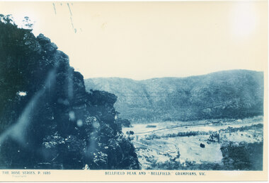
Photo is of Fyans Valley with Hotel Bellfield in the valley. Photo is taken from Bellfield Peak. c1940sA rocky outcrop on far left of photo. a cleared valley with buildings and roads in foreground, flanked by a mountain range.THE ROSE SERIES. P 1695 BELLFIELD PEAK AND "BELLFIELD," GRAMPIANS, VIC scenery, fyans valley -
 Halls Gap & Grampians Historical Society
Photograph, C 1960s
The valley is known as Fyans Valley and the township of Halls Gap. Photo is typical of those taken by the Forestry Commission (Vic) during the 1960s.Photo shows two rocky outcrops in the foreground framing a valley in the distance below. A partial view of a mountain range flanks the valley. Plains of trees and open fields, and also a lake, can be seen beyond the mountain range. Within the valley in the middle of the photo buildings, roads and cleared land can be seen.scenery, fyans valley -
 Halls Gap & Grampians Historical Society
Photograph - B/W
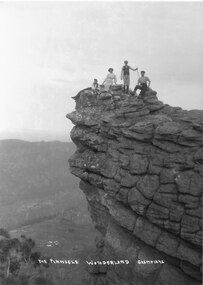
Photograph is taken at the Pinnacle in the Wonderland Range. The valley below is the Fyans Valley.Three men and a woman laying, sitting and standing on top of a high rocky outcrop. The woman and two men wear hats and the man standing is holding a stick. A mountain range can be seen opposite them with a valley far below, between the two ranges. A group of buildings can be seen in the valley. The style of dress worn by the people suggests early 1900s.The Pinnacle Wonderland Grampiansscenery, wonderland range -
 Flagstaff Hill Maritime Museum and Village
Tool - Saw gauge, Henry Disston, 1890-1920
Disston Saw Works of Philadelphia was one of the better known and highly regarded manufacturers of handsaws in the United States. During the Machine Age, the company was known as Henry Disston & Sons, Inc. a supplier of industrial saw blades. History: The story of handsaws in the United States mirrors the technical and development of steel in Sheffield, England, which was the center of handsaw production during the 18th century and through most of the 19th century. England's political and economic lock-on steel making in the colonies held American saw makers at bay until well after the Revolutionary War. American steel producers were unable to compete until the US government introduced import tariffs to level the playing field in 1861. Henry Disston: Henry Disston (1819–1878) began his career as an American saw maker in Philadelphia. He had emigrated from England in 1833 and started making saws and squares in 1840. In 1850, he founded the company that would become the largest saw maker in the world, the Keystone Saw Works. Some five years later, Disston built a furnace—perhaps the first melting plant for steel in America and began producing the first crucible saw steel ever made in the United States. While his competitors were buying good steel from Britain, he was making his own, to his specification, for his own needs. Disston subsequently constructed a special rolling mill exclusively for saw blades. Over the following decade, the Disston company continued to grow, even while dedicating itself to the Union Army's war effort. In 1865, when his son Hamilton Disston rejoined the business after serving in the Civil War, Disston changed the company's name to Henry Disston & Son. Henry Disston and his sons began to set the standards for American saw makers, both in terms of producing high-quality saws and files in 1865 through his development of innovative manufacturing techniques. In September 1872, Henry Disston and two other men dug a part of the foundation for what was to become the largest saw manufacturing facility in the world: Disston Saw Works. This was in the Tacony section of Philadelphia. Having previously moved his expanding business from near Second and Market Streets to Front and Laurel Streets. It took over 25 years to move the entire facility to Tacony. Henry Disston was renowned for having one of the first industries that exhibited environmental responsibility, as well as a paternalistic view towards his employees. For example, he had thousands of homes built in Tacony for his workmen. Funds to purchase these homes were made available through a building and loan association set up by the Disston firm. His caring influence on the community was evident in everyday life. To meet employees' cultural needs, a hall and a library were built with Henry Disston agreeing to pay a fixed sum towards its maintenance. The Tacony Music Hall was erected in 1885, also with the assistance of Disston money. Henry Disston had fallen ill by 1877 and never truly recovered; he suffered a stroke and died the next year. This came only one and a half years after seeing his products receive the highest honors at the great Philadelphia Centennial Exposition of 1876. His vision of a working-class community and the completion of the transfer of his enormous saw plant was carried out by his wife and his sons. The company, by the early 20th century, cast the first crucible steel in the nation from an electric furnace in 1906. The firm's armor-plate building near Princeton Avenue and Milnor Street contributed tremendously to the World War II effort. But the company's innovation and industriousness would not last forever. In 1955, with mounting cash-flow problems and waning interest on the family's part to run the firm, Henry Disston and Sons were sold to the H.K. Porter Company of Pittsburgh. Porter's Disston Division was sold in 1978 and became the Henry Disston Division of Sandvik Saw of Sweden. This division was then sold in 1984 to R.A.F. Industries of Philadelphia and became known as Disston Precision Incorporated, a maker of specialized flat steel products. In 2013, R.A.F. Industries sold Disston Precision Inc. in a private sale. Although the company has ceased making Disston handsaws, the Disston brand name still exists in this firm. A tool used to set and sharpen cross cut saws used to fell trees for building construction made by a well known American maker whos firm pioneered the making of saws and their related items including files.combination cross cut saw raker and gauge/jointerDisston USA in the castingflagstaff hill, warrnambool, shipwrecked-coast, flagstaff-hill, flagstaff-hill-maritime-museum, maritime-museum, shipwreck-coast, flagstaff-hill-maritime-village -
 Flagstaff Hill Maritime Museum and Village
Document - Framed Poster, Borough of Warrnambool, Victoria, Australia, after 30/06/1875
This document, also referred to as a word picture or Tablet, is framed in glass and timber with gilt trim, is handwritten with colour highlights. The penned letters rest on ruled guide lines, decorated where the lines intersect. The writing gives a description of the state of Borough of Warrnambool around 1875; its location, the area it covers, its population, Harbour and facilities, public buildings and institutions, imports and exports, financial worth, number of houses, connection with other areas of the Colony. A possible reason and origin for the document is found in an article ‘Link with US Exhibition’ from the Warrnambool Standard of December 19, 1981, written by local historian Bruce Morris. The writer mentions that the Warrnambool Borough Council met on 15th June 1875 and recorded a letter from G.C. Levey , secretary to the Melbourne group of commissioners representing the Colony, and Victoria in particular, for the Philadelphia Centennial Exhibition of 1876. The letter asks Council to provide “statistics as to the population, social condition and commercial and industrial state of the district in and around Warrnambool.” A sub committee was formed for the project. The Mayor, Cr. Thomas King, wrote and signed a Report, presented to the council on July 14, 1875, in which “The Committee … begs to recommend that a Tablet be prepared setting for the particulars respecting the following matters relating to the Borough”. The matters included area, population, annual income, churches, schools, other public buildings, societies and companies, general description of houses erected, and returns of exports and imports for 1874. The minutes note that the Report was adopted. The article above also notes the opinion of Warrnambool printers who have examined the document; it is almost certainly to be an old lithograph, which means there could be several copies. It is possible that there may be a copy in Melbourne and another in Philadelphia. It is interesting to note that (1) the quoted location co-ordinates are for an “Unnamed Road, Packsaddle NSW 2880, Australia”, and that the DMS co-ordinates for Warrnambool’s Council Offices differ, being 38.23.9.12 South, 142.28.52.887. (2) the date for “Exports and Imports for the Year Ending 30th June 1875” is different to the period mentioned by Cr. King in the sub committee’s Report of recommendation “returns of exports and imports for 1874”. The information required to have the figures for the end of June 1875 would need to have been compiled very quickly for the Tablet to be ready for the opening of the Philadelphia Exhibition on 10 May 1876. The document/certificate shows the following – - - - - - - - - - - - - - - -- - - - - - - - - - - - - - -- - - - - - - - - - - - - - -- - - - - - - - - - - - - - - “Victoria Australia, Borough of Warrnambool. Latitude, 30.24.50 South, Longitude 142.32 East The Principal Port in the Western District of the Colony and the Centre of its Choicest Agricultural Lands. Established a Municipality in 1855, and Created a Borough 1863. Population in 1875 4,500. Warrnambool is the nearest Port to Melbourne on the Western Seaboard, being about 160 miles distant. Coaches run to and from the Metropolis daily, in connexion [connection] with the Railway of Geelong and Steamers belonging to Local Companies sail between Melbourne, Warrnambool, Belfast [renamed Port Fairy], and Portland several times weekly. The Harbour is known as Lady Bay, and is partially protected by a reef of rocks stretching from the mouth of the Hopkins River. The formation of a Breakwater has been decided upon by the Government, to extend 600 yards, at an estimated cost of £100,000. There are two substantial Jetties, one of 800 and the other of 600 feet in length. The former is connected with the Town by means of a Tramroad, along which Goods, inwards & outwards, are conveyed, & the latter has been constructed solely for the purpose of facilitating the transit of material for the formation of the Breakwater. In addition to the trade of the Borough and District, the principal Townships up country receive their supplies from Melbourne and ship their exports through Warrnambool. Potatoes form the staple produce of the district, and the richness of the soil can be estimated by the fact that the Government Statistics for 1875 give as the average yield a return of Seven Tons to the acre. Several thousand acres between Warrnambool and Tower Hill are now being laid down in Potatoes by Tenants who have leased the lands at rates up to £5 per acre for the season 1875-6. Wool, Tallow, hides &c are also largely exported, while the shipments of all descriptions of Farm Produce are annually increasing. Area of Borough, 3362 Acres. Net Annual Value £27,000. Annual Revenue £5,500. Number of Houses in Borough 800. Public Buildings and Institutions Churches. Church of England, Roman Catholic, Presbyterian, Wesleyan, Congregational and Baptist. Schools. Three State Schools, average attendance nearly 1000. New Building in course of erection. Several private establishments. Banks. Bank of Australasia, Bank of Victoria, National Bank, Colonial Bank and Savings Bank. Public Buildings. Court house, Custom house, Post & Telegraph Offices, Survey & Land Offices, Shire £, Town Hall, Mechanics Institute, Volunteer Orderly Room, Odd Fellows Hall, Hospital & Benevolent Asylum, Temperance Hall &c. Companies & Societies. Steam Navigation Co, Woolen Mill Co, Gas Co, Racing Club, Amateur Turf Club, Agricultural Society, Farmers’ Club, Cricket Club, Anglers’ Society, Building Society, Freemasons Odd Fellows, Foresters, Druids, Hibernians. Protestant Alliance, Rechabites, Sons of Temperance, &c, Fire Brigade &c. --- Exports and Imports for the Year Ending 30th June 1875 –-- --Exports Total Tonnage 27,800 (Calculated at the Current Warrnambool Market Prices) Potatoes Wool Wheat Barley Hides Skins Fowls Butter Cheese Eggs Tallow Leather Ale Pigs Sheep Sundries --Imports 13,000 Tons Of the Estimated Value of £520,000 Total Tonnage of Exports and Imports 40m900 Tons, Value £806,627 Passenger Travels, to ad from Warrnambool during year, 10,000 persons Revenue from all sources paid through Warrnambool Sub Treasury From 1860 to June 1875 £1, 292, 300 Thomas King [signed] Mayor Henry T Read [signed] Town Clerk” - - - - - - - - - - - - - - -- - - - - - - - - - - - - - -- - - - - - - - - - - - - - -- - - - - - - - - - - - - - - The document is of historical, social, economic and local significance in that it summarises activities, business, community, trade, travel and government at a point in time in Warrnambool’s history – 30th June 1875.Document, also referred to as a ‘word picture’ or ‘tablet’. Document is framed in glass and timber with gilt trim, handwritten with colour highlights. The penned letters rest on ruled guide lines, decorated where the lines intersect. Document outlines the establishment of Warrnambool as a Municipality in 1855 and Borough in 1863, with a population of 4,500 in 1875. It states geographic location, public buildings and institutions, harbor facilities and imports and exports for the year ending 30th June 1875. Two signatures "Thomas King" Mayor and "Henry T Read" Town Clerk. It shows the Coat of Arms of the Borough of Warrnambool.Signatures - "Thomas King" Mayor and "Henry T Read" Town Clerk. Warrnambool Coat of Arms; “British Coat of Arms, above sailing vessel and sheaf of wheat in sun, motto “By these we flourish” and around circumference “Borough of Warrnambool 1855”flagstaff hill, warrnambool, shipwrecked coast, flagstaff hill maritime museum, maritime museum, shipwreck coast, flagstaff hill maritime village, great ocean road, borough of warrnambool, municipality of warrnambool, document borough of warrnambool 1875, word picture of warrnambool 1875, tablet of borough of warrnambool 1875, statistics borough of warrnambool 1875, lithograph borough of warrnambool 1875, coat of arms warrnambool, warrnambool city motto – in these we flourish, establishment of warrnambool, warrnambool history, thomas king mayor of warrnambool, henry t read town clerk of warrnambool, warrnambool breakwater, warrnambool jetty, warrnambool imports and exports 1875, warrnambool agriculture 1875, warrnambool business 1875, warrnambool population 1875, centennial exhibition philadelphia 1876, framed certificate -
 City of Moorabbin Historical Society (Operating the Box Cottage Museum)
Booklet - The Christ Church Chronicles 1900 -2001 - A presentation of Christ Church, Ormond's history for its Centennial celebrations, by Val Manson, 2001
Christ Church Ormond has been standing on the corner of North Road and Wheatley Road for over 100 years, but not always in its present form. Originally it was a weatherboard building built in 1901. Now called Ormond Anglican Church.Christ Church Ormond has served the community since 1900, was integral to the spiritual well being and social life of the early settlers.Typed document containing photos and diagrams - 74 pagesearly settlers, parish of moorabbin, city of moorabbin, county of bourke, shire of moorabbin, market gardeners, christ church ormond, ormond, north road, wheatley road -
Bendigo Historical Society Inc.
Painting - THE MELBOURNE CENTENNIAL EXHIBITION 1888, 1888
... PRINT Buildings commercial & public Melbourne Centennial ...Print: Large colour print of the Exhibition Buildings Melbourne, 'Supplement to The Australian' August 4th 1888Troedel and Co, Printersprint, buildings, commercial & public, melbourne centennial exhibition 1888, exhibition buildings, the aystralian, troedel and co. -
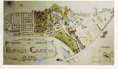 University of Melbourne, Burnley Campus Archives
Slide - Colour slide, Milton Gellert, Department of Agriculture Burnley Gardens Victoria, 1955-1990
... for the Centennial Year in 1990. Note by T.H. Kneen 18 March 1992 ...Copied for use as a postcard for the Centennial Year in 1990. Note by T.H. Kneen 18 March 1992, "The original drawing was done by Milton Gellert and for a considerable time was displayed in the Fruit Preserving Branch's display window. This was Milton's own concept and was probably done in late 50's. Milton was on Burnley Staff 1955-57 & then employed at Plant Research Institute, Burnley Gardens." The picture was later hung in the Staff Room in the Administration Building but has disappeared.2 copies, large colour negative. Coloured hand drawn plan of of the whole site in a frame. Photographed in 1965.centennial year, milton gellert, fruit preserving branch, staff, plant research institute, burnley gardens, hand drawn plan of site, 1991, plan -
Malmsbury Historical Society
Photograph (Item), Bi-Centennial Parade (1988), Malmsbury ca1989
... -ranges People - Kyneton Band Buildings - Mollison Street Bi ...People - Kyneton Band Buildings - Mollison Street -
Malmsbury Historical Society
Photograph (Item), Bi-Centennial Parade (1988), Malmsbury ca1989
... -ranges Buildings - Mollison Street Bi-Centennial Parade (1988 ...Buildings - Mollison Street -
Malmsbury Historical Society
Photograph (Item), Bi-Centennial Parade (1988), Malmsbury ca1989
... -ranges People - "Slimmon, Richard & Bruce" Buildings - Mollison ...People - "Slimmon, Richard & Bruce" Buildings - Mollison Street -
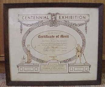 National Wool Museum
Certificate, Centennial Exhibition Certificate of Merit
... Australian Centennial Exhibition, 1936. Textile Mills history South ...Gold medal certificate presented to Collins Bros Mill Pty Ltd for the best grouped exhibit at the South Australian Centennial Exhibition, 1936.CENTENNIAL EXHIBITION / Gold Medal / Certificate of Merit / AWARDED TO / Collins Bros Pty Limited / FOR / Attractive Stiff Grouped Exhibit / from an Exhibition point of view / [signature] PRESIDENT / [signature] SECRETARY / ART / INDUSTRY / TO CELEBRATE / THE HUNDREDTH ANNIVERSARY / OF THE / FOUNDATION OF SOUTH AUSTRALIA. / SOUTH AUSTRALIAN CHAMBER OF MANUFACTURERS INCORPORATED / 1836 / 1936 / Albert V. Adlam From- / ROBT. R. STANESBY / THE PICTURE FRAM MAKER, / MOUNT CUTTER, &c. / FREE LIBRARY BUILDINGS, / Moorabool St., Geelongtextile mills history, south australian chamber of manufacturers incorporated collins bros mill pty ltd, textile mills - history -
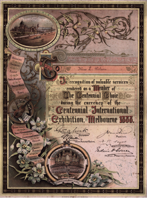 Kew Historical Society Inc
Certificate, McCarron Bird & Co, The Centennial Choir, Centennial International Exhibition, 1888
A Report of the Commissioners, presented to Parliament in 1891, noted that: ‘The great Musical Festival, which was inaugurated and maintained during the time the Exhibition was open, was such as had never before been attempted. In that comparatively short period, no less than 263 orchestral, grand choral, and other concerts were given by the Centennial Orchestra and Choir, numbering nearly 800 performers, under the conductorship of Mr. F. H. Cowen. At these concerts the works of the great masters were performed in a manner hitherto unknown in these colonies, and your Commissioners are encouraged to hope that the stimulus given through their agency to the study of Music will prove strong and lasting. They also desire to return their thanks to the ladies and gentlemen composing the Centennial Choir, who devoted much time to the rehearsal and performance of the great choral works given during the Festival, and whose valuable services were rendered gratuitously.'An illuminated certificate inscribed to Miss L. Wilson in ‘recognition of valuable services rendered as a member of the Centennial Choir during the currency of the Centennial International Exhibition, Melbourne 1888’. The illuminated certificate lists a number of works performed by the choir, at left, and also pictorial roundels of the exterior of the Exhibition Building and of its grand organ. Attached to the card on which the certificate is also attached is a separate Memorandum from the Music Business Manager to Miss Wilson. No other correspondence is extant to explain the reason for her request.Inscription: To Miss L. Wilson / In recognition of valuable services / rendered as a Member of / The Centennial Choir / during the currency of the / Centennial International/ Exhibition, Melbourne 1888. Separate Memorandum: CENTENNIAL INTERNATIONAL EXHIBITION MEMORANDUM FROM EXHIBITION BUILDINGS FITZROY 8/10/1888 E. MILLER (MUSIC BUSINESS MANAGER) TO Miss Wilson Dear Madam In answer to your note I have the honor to inform you that you may remove your dress at any time, though you may need to show your choir pass & may have to submit to parcel being looked at - as the Customs officers are obliged to keep a very careful watch on any outgoing parcels. Yours obediently E. Millercentennial choir - 1888, centennial exhibition - melbourne (vic) - 1888, certificates -
Friends of Ballarat Botanical Gardens History Group
Work on paper - Victor Greenhalgh 1900-1983, Famous Sculptor from Ballarat, John Garner's notes, 2009
Greenhalgh sculpted the heads of 6 Prime Ministers' heads in the Prime Ministers' Avenue, Ballarat Botanical Gardens.Victor Greenhalgh became a famous Australian sculptor whose work is highly regarded, especially in Ballarat and Victoria.1 sheet of notesNonejohn garner, doctor, ballarat botanical gardens, victor greenhalgh, greenhalgh road., school of mines, prime ministers' avenue, prime ministers' busts, rmit scholarship., national gallery, george v statue, deakin university (mt clear) dick richards bust, centennial medal. -
 University of Melbourne, Burnley Campus Archives
Photograph - Colour print, Edna Geyeregger, Sculpture Exhibition 1991, 24 September 1991
Donated by Mrs. Edna Geyeregger, taken 24 September 1991.Colour photographs. Sculpture Exhibition part of the1991 Centennial Celebrations. Photographs taken of the Gardens: (1) Outside Herb Garden looking towards Wisteria Walk. (2) Hilda Kirkhope Rockery. (3) Wisteria Walk. (4) Hilda Kirkhope Rockery. (5) Luffmann Ponds. (6) Hilda Kirkhope Rockery and Staff Carpark, in front of Administration Building Reception. (7) Sunken Garden. (8) Sunken Garden. (9) Sunken Garden. (10) Sunken Garden. (11) Luffmann Ponds.sculpture exhibition, 1991, edna geyeregger, herb garden, wisteria walk, hilda kirkhope rockery, luffmann ponds, staff carpark, sunken garden, centennial celebrations -
Clunes Museum
Ephemera - FIRE MARKS
Buildings had wooden or metal plaques in the form of an Insurance Brigades coat of arms or Firemark affixed to their exteriors denoting which insurance company had the building under its care. When the fire alarm was given many companies would rush to the scene, the mark would be inspected, and only the Brigade that owned the mark would fight the fire while the other companies would do their best to hinder the operation. Source: "Life Under The Bells" by Sally Wilde (ISBN 0 582 87023 2) published by Longman Cheshire in 1991 on the occasion of the centennial of the Board, (MFB).1 Gold lettering and shield border .2 Raised image of fireman with hose and building .3 Supplementary information about fire marks by the donor .4 SQUARE PLAQUE WITHRAISED BLUE BACKGROUND, THREE GOLD TIGER HEADS, 5. LARGE SQUAERE WITH CIRCLE RAISED, PICTURE WITH FIREMAN IN FROM OF CART, HOLDING AXE..1 Colonial .2 Protector .3 Nil 4. SALOP 5. BIRMIN GHAMfiremark, insurance, colonial, protector -
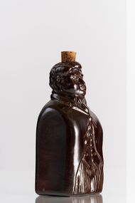 City of Greater Bendigo - Civic Collection
Ceramic - Bendigo Pottery :: Australian Prime Minister Flask, Bendigo Pottery, Sir Edmund Barton, c 1975
Established by George Guthrie in 1857 (about 5km north of its current site) and then again seven years later in 1864 after it initially closed, Bendigo Pottery remains one of the most influential and longest running Pottery’s in Australia. Over the years the Pottery has contributed to the growth and development of the district through both its products including building products, table ware and decorative and commemorative war as well as artistically, being responsible for training and supporting many potters locally. The City of Greater Bendigo has had a long history of partnering with Bendigo Pottery and the Civic Collection holds a number of important items within its collection. This Sir Edmund Barton 'reform' flask was one of a limited edition character bottles produced by the Pottery to commemorate his contribution to Australian politics. Edmund Barton became Australia’s first Prime Minister on New Year’s Day 1901, at a huge public ceremony in Centennial Park in Sydney. Reform flasks were English salt-glazed stoneware flasks produced in the early 19th century shaped into the form of figures connected with the Reform Bill of 1832. Much was made of puns like ‘the spirit of reform’ at the time. Artist John Frith has taken the reform flask form as inspiration for a series of political ceramics of some Australian Prime Ministers. The series includes Edmund Barton, Alfred Deakin and Chris Watson. Glazed ceramic flask in the shape of Sir Edmund Barton. Square shaped with most of the detail on the front facing side other than head which is more detailed. Cork still in place in top of head.On reverse of flask; Sir Edmund / Barton / Prime Minister / of Australia / 1901 to 1908 Bendigo Pottery / LMTED / Edition Series / 110/1200 /Australia Signed lower centre; 'Frith'australian politics, bendigo pottery