Showing 856 items
matching council offices
-
 Sunbury Family History and Heritage Society Inc.
Photograph, Veronica Burgess, Alister Clark Rose Garden, 12th December 1999
... . The garden is in the grounds of the former Shire of Bulla council.... The garden is in the grounds of the former Shire of Bulla council ...The man in the photograph is Alan McKenzie a long time resident of Bulla. He was a guest at the official opening in Bulla of the Alister Clark Memorial Rose Garden on 12th December 1999. The garden is in the grounds of the former Shire of Bulla council offices. Alister Clark developed many varieties of roses at his property, 'Glenara' in Bulla.The establishment of the Memorial Rose Garden in Bulla acknowledges the contribution made by Alister Clark to gardens in Victoria.A non-digital coloured photograph of a man standing beside a timber arch in a garden. A small bluestone building with a slate roof is in the background.alister clark, alister clark memorial rose garden, glenara homestead, bulla, rose gardens -
 Orbost & District Historical Society
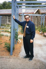
Invitation, 1969
... of the new Orbost Shire Council Municipal Offices. A light blue card... to the official opening of the new Orbost Shire Council Municipal Offices ...The current building was opened on Friday 28th February 1969 by the Premier of Victoria, The Hon. Sir Henry E. Bolte, K.C.M.G., M.P. The Shire of Orbost was a local government area about 380 kilometres east of Melbourne, the state capital of Victoria, Australia. The shire covered an area of 9,347 square kilometres and existed from 1892 until 1994. Originally, Orbost was part of the Bairnsdale Road District which was created on 30 April 1867. Splitting away as part of the Shire of Tambo in 1882, Orbost was first incorporated as a shire in its own right as the Shire of Croajingolong on 30 May 1892. It received its present name on 17 February 1893. On 3 January 1913 part of its western riding was annexed to Tambo as its Cunninghame Riding. Local governments play an important role in the lives of citizens in Australia. Local government authorities exist to provide services and amenities to local communities, and are also responsible for regulating and providing services for land and property in their district. This item is representative of a time when Orbost had its own Shire Council. A stapled program and invitation to the official opening of the new Orbost Shire Council Municipal Offices. A light blue card with the Orbost Shire Council insignia and gold print on front. The invitation is addressed to the secretary of Orbost Historical Society Judith Walcott.handwritten in blue pen - "Judith G Walcott"orbost-shire-council -
 Greensborough Historical Society
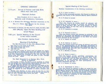
Article, Rotary Club of Greensborough, Greensborough's newest street - Vickers Way, 12/07/2006
... entrance to WaterMarc and Banyule Council offices.... Council offices. Tom Vickers was a prominent member ...Front page article from the Rotary Club of Greensborough's newsletter, includes photographs of the murals on Vickers Way Greensborough, named after the late Tom Vickers, local pharmacist and Charter President of the Greensborough Rotary Club. Unfortunately, the murals have gone following the redevelopment of the Main Street entrance to WaterMarc and Banyule Council offices.Tom Vickers was a prominent member of the community and a local pharmacist.Digital copy of articlevickers family, tom vickers, vickers way greensborough, main street greensborough -
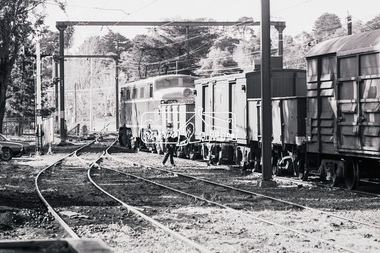
 Eltham District Historical Society Inc
Photograph, George Coop, Victorian Railways electric locomotive L1159 at Eltham Railway Station, 23 August 1983, 1983
... Eltham Shire Council offices in background L series... melbourne Eltham Shire Council offices in background L series ...Eltham Shire Council offices in background L series electric locomotive L1159 was introduced into service 12 August 1953 and withdrawn 27 April 1987. It was scrapped January 1988. Source: [email protected] https://vicsig.net/index.php?page=locomotives&number=1159&class=L&type=Electric%20(1500V%20DC)&orgstate=VDigital TIFF file Scan of 35mm Kodak Safety 5062 black and white transparencyeltham railway station, eltham shire office, freight train, l class electric locomotive, l1159 -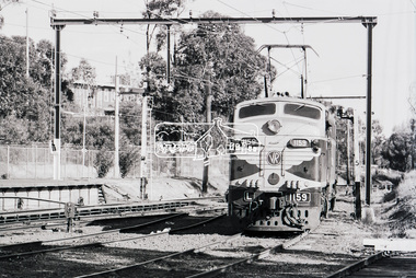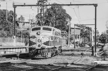
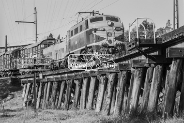 Eltham District Historical Society Inc
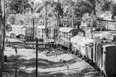
Photograph, George Coop, Victorian Railways electric locomotive L1159 and freight cars traversing the Eltham Railway Trestle bridge, 23 August 1983, 1983
... Eltham Shire Council offices in background L series... melbourne Eltham Shire Council offices in background L series ...Eltham Shire Council offices in background L series electric locomotive L1159 was introduced into service 12 August 1953 and withdrawn 27 April 1987. It was scrapped January 1988. Source: [email protected] https://vicsig.net/index.php?page=locomotives&number=1159&class=L&type=Electric%20(1500V%20DC)&orgstate=VDigital TIFF file Scan of 35mm Kodak Safety 5062 black and white transparencyeltham shire office, eltham trestle bridge, freight train, l class electric locomotive, l1159 -
 Warrnambool and District Historical Society Inc.
Administrative record (Collection) - Warrnambool City Council Administrative Records, Warrnambool City Council Officers, 1990s
... . The Warrnambool City Council offices are in Liebig Street, Warrnambool..... The Warrnambool City Council offices are in Liebig Street, Warrnambool ...Warrnambool City Council Records collected by a member of a Council Advisory Committee.Collection of Warrnambool City Council records of the 1990sIn folders and archival envelopes in an A3 archival boxTwo A3 archival envelopes containing information on Foreshore etc., five booklets containing reports on City Plans, Council Strategies etc and 15 Reports (Shop Trading, Coastal Wetlands, Foreshore, Landcare etc)warrnambool city council, warrnambool city council strategies and planswarrnambool city council, warrnambool city council strategies and plans -
 Eltham District Historical Society Inc
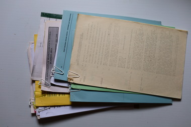
Document - Folder, Saper, Leon
... exhibition of work of Leon Saper at Nillumbik Council offices.... exhibition of work of Leon Saper at Nillumbik Council offices. Leon ...Leon Saper was a potter and a founding member of Clifton Pugh's Dunmoochin artists colony. Contents Newspaper article: Paragraph noting death of Leon Saper after a long illness, Diamond Valley Leader, 4 May 2005. Newspaper article: "Potter's place in arts history", Diamond Valley News, 25 May 2005. Retrospective exhibition of work of Leon Saper at Nillumbik Council offices.Newspaper clippings, A4 photocopies, etcleon saper, clifton pugh, dunmoochin, kela shakahn, st andrew's market, bryan walters, don thomson, catherine thomson, michael trembath, christine tuisku, jukka tuisku, julie coulson, holocaust survivor, stella saper, alexandre saper, george bell, morrice shaw, myra skipper, frank werther, ruth saper, aaron saper, tony trembath -
 Warrnambool and District Historical Society Inc.
Map, Plans (5) showing Subdivisions of Warrnambool, 1989
... in the Warrnambool City Council offices. The scale of the plans was 1... and ledgers in the Warrnambool City Council offices. The scale ...These plans have been drawn by Steve Hester for the Warrnambool City Council to illustrate the allotments in Warrnambool concerned with the subdivisions of 1989. The streets have not been named but there is an indication of the area with the identification of known buildings (eg Hospital) and the plan numbers of each allotment is clearly marked. These numbers corresponded to the plan numbers registered in card files and ledgers in the Warrnambool City Council offices. The scale of the plans was 1 to 5000. These plans are of considerable interest because they show Warrnambool street subdivisions of 1989 in illustrative form. They show how information was collated in the late 1980s before the widespread use of computer digital means to describe and store information.These are five hand-drawn sheets showing plans of sub-divisions in Warrnambool streets in 1989 (Warrnambool City Council material). The plans are multi-coloured (crayons) and show allotments with plan numbers. The first plan has much of the material torn off but the location is known to be in the Russells Creek area. Some of the green tape around the edges is missing. Plans two to five are almost intact and are bound with green tape. Plan Two- Industrial Estate of West Warrnambool; Plan Three – Hospital/Merrivale/ Lake Pertobe areas; Plan Four – North Warrnambool, Wollaston/Brierly areas; Plan Five – Flaxman Street area. ‘Subdivision Plan, Reference Guide, Steve Hester, Oct. 1989’. warrnambool street subdivisions, steve hester, history -
 Eltham District Historical Society Inc
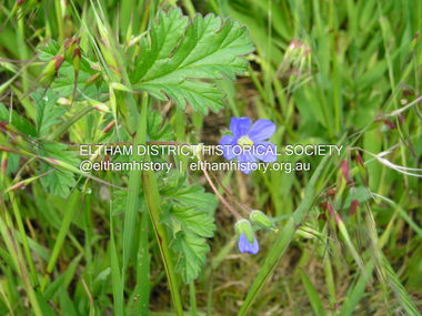
Photograph, Fay Bridge, Blue Cranespill, 895 Main Road, Eltham, 15 October 2016
... of the carpark of the former Eltham Council offices at 895 Main Road... of the carpark of the former Eltham Council offices at 895 Main Road ...A blue Cranespill Geranium growing on the verge of the carpark of the former Eltham Council offices at 895 Main Road. In the Advisory list of environmental weeds in Victoria (White, Cheal, Carr et al April 2018), this plant is a declared environmental weed in Victoria with a medium risk. At a Society Heritage Excusrion conducted Saturday, September 2, 2023 it was noted that the banks of the carpark where this photo was taken had recently been sprayed and weed growth was dying.fay bridge collection, 895 main road, 2016-10-15, blue cranesbill, environmental weed -
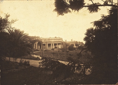
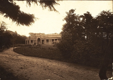
 Kew Historical Society Inc
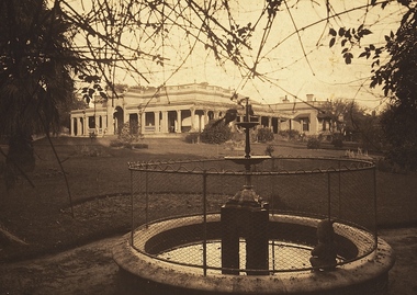
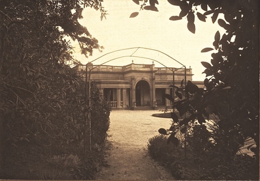
Photograph - 'Southesk' (formerly 'Ordsall'), Cotham Road, 1920s
... . The house and land were later acquired by Council in 1947.... The present Kew Library and the former Council Offices (now owned ...Ordsall was originally built for John Halfey, second Chairman of Kew, and sold after his death to the Carnegie family who renamed it ‘South Esk'. The Carnegie family mounted a defence of their property when the City of Kew sought to compulsorily acquire the site for a new town hall in the 1930s. The house and land were later acquired by Council in 1947 and demolished in 1970. The present Kew Library and the former Council Offices (now owned by Trinity Grammar) are located on the site.One of the earliest photographs of 'Southesk' and its gardens. The house was of statewide significance because of its historical association with John Halfey. It was artistically significant due to its elaborate interiors, decorated by Cullis Hill & Co in the 1880s. Sepia photograph mounted on brown card of "Southesk' (formerly known as 'Ordsall'). The single-storey Italianate facade of the house can be seen surrounded by an extensive garden. The point-of-view of the camera is from Cotham Road.john halfey, david carnegie, southesk - south esk - ordsall -
 Kew Historical Society Inc
Photograph - 'Southesk' (formerly 'Ordsall'), Cotham Road, 1920s
... . The house and land were later acquired by Council in 1947.... The present Kew Library and the former Council Offices (now owned ...Ordsall was originally built for John Halfey, second Chairman of Kew, and sold after his death to the Carnegie family who renamed it ‘South Esk'. The Carnegie family mounted a defence of their property when the City of Kew sought to compulsorily acquire it as the site for a new town hall in the 1930s. The house and land were later acquired by Council in 1947 and demolished in 1970. The present Kew Library and the former Council Offices (now owned by Trinity Grammar) are located on the site.One of the earliest photographs of 'Southesk' and its gardens. The house was of statewide significance because of its historical association with John Halfey. It was artistically significant due to its elaborate interiors, decorated by Cullis Hill & Co in the 1880s. Sepia photograph mounted on brown card of "Southesk' (formerly known as 'Ordsall'). The single-storey Italianate facade of the house can be seen surrounded by an extensive garden. The point-of-view of the camera is from Cotham Road.john halfey, david carnegie, southesk - south esk - ordsall -
 Kew Historical Society Inc
Photograph - 'Southesk' (formerly 'Ordsall'), Cotham Road, 1920s
... . The house and land was later acquired by Council in 1947.... The present Kew Library and the former Council Offices (now owned ...Ordsall was originally built for John Halfey, second Chairman of Kew, and sold after his death to the Carnegie family who renamed it ‘South Esk'. The Carnegie family mounted a defence of their property when the City of Kew sought to compulsorily acquire it as the site for a new town hall in the 1930s. The house and land was later acquired by Council in 1947 and demolished in 1970. The present Kew Library and the former Council Offices (now owned by Trinity Grammar) are located on the site.One of the earliest photographs of 'Southesk' and its gardens. The house was of statewide significance because of its historical association with John Halfey. It was artistically significant due to its elaborate interiors, decorated by Cullis Hill & Co in the 1880s. Sepia photograph mounted on brown card of "Southesk' (formerly known as 'Ordsall'). The single-storey Italianate facade of the house can be seen surrounded by an extensive garden. The point-of-view of the camera is from Cotham Road.john halfey, david carnegie, southesk - south esk - ordsall -
 Kew Historical Society Inc
Photograph - 'Southesk' (formerly 'Ordsall'), Cotham Road, 1920s
... . The house and land were later acquired by Council in 1947.... The present Kew Library and the former Council Offices (now owned ...Ordsall was originally built for John Halfey, second Chairman of Kew, and sold after his death to the Carnegie family who renamed it ‘South Esk'. The Carnegie family mounted a defence of their property when the City of Kew sought to compulsorily acquire it as the site for a new town hall in the 1930s. The house and land were later acquired by Council in 1947 and demolished in 1970. The present Kew Library and the former Council Offices (now owned by Trinity Grammar) are located on the site.One of the earliest photographs of 'Southesk' and its gardens. The house was of statewide significance because of its historical association with John Halfey. It was artistically significant due to its elaborate interiors, decorated by Cullis Hill & Co in the 1880s. Sepia photograph mounted on brown card of "Southesk' (formerly known as 'Ordsall'). The single-storey Italianate facade of the house can be seen surrounded by an extensive garden. The point-of-view of the camera is from Cotham Road.david carnegie, john halfey, southesk - south esk - ordsall -
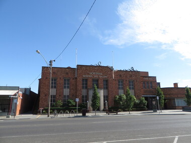 Ballarat Heritage Services
Photograph - Photograph - Colour, Clare Gervasoni, Horsham Art Gallery (Horsham Town Hall), 2017, 2017
... council offices which is the building it resides in today... council offices which is the building it resides in today ...The gallery was founded in 1967 as a one-room gallery within Horsham’s library building. In 1983, after the offer of a major bequest from Mr Mack Jost AM, it moved to the former council offices which is the building it resides in today. The 1939 Art Deco building provides elegant and human-scale spaces for the display of the collection and temporary exhibitions. Over the years the gallery has been extended and upgraded, with the final renovations done in 2016 to become a part of the Horsham Town Hall.lPhotographs of the Horsham Ar Gallery which is housed in the Horsham Town Hall.horsham art gallery, horsham town hall, horsham logo, horsham regional art gallery -
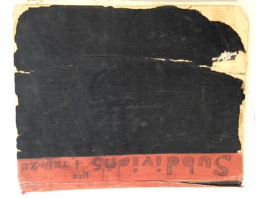 Warrnambool and District Historical Society Inc.
Book, Subdivision No 1 to 1420, 1930s
... be held in the Warrnambool City Council offices per electronic... Council offices per electronic data storage. Warrnambool, founded ...This is an exercise book listing subdivisions in Warrnambool from 1935 to 1977. There are 1420 entries. It gives details of the subdivisions – plan number, street, section number, allotment number, date, owner, solicitor and Titles Office number. The book is completely filled and today this information would be held in the Warrnambool City Council offices per electronic data storage. Warrnambool, founded in 1847, became a Municipality in 1856, a Borough in 1863, a Town in 1883 and a City in 1918. Subdivisions of land in the city continue to be made regularly for housing and business purposes.This book is of great historic interest because it details the subdivisions in the City of Warrnambool from 1935 to 1977. It shows the continuing growth of the city, particularly after World War Two. It will be a very useful resource for researchers. This is an exercise book with a black cardboard cover and red binding. It contains a list of City of Warrnambool subdivisions from 1935 to 1977. The cover and some of the pages are torn and ragged and the binding has come apart and has been glued together in places. The pages are ruled with blue and red lines. The pages contain handwritten material in black and blue ink. Front Cover: ‘Subdivions(sic), Nos 1 to 1420’ Inside Front Cover: ‘City of Warrnambool Subdivisions’ warrnambool city council, warrnambool subdivisions -
 Glen Eira Historical Society
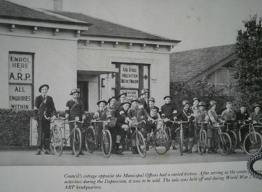
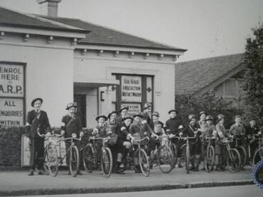
Air Raid Precaution (ARP) in Caulfield
... World War 2, formerly a Caulfield Council cottage opposite... a Caulfield Council cottage opposite Municipal Offices Air Raid ...Photograph of Air Raid Precaution headquarters during World War 2, formerly a Caulfield Council cottage opposite Municipal Officescaulfield, air raid precaution, world war 1939-1945, caulfield council, hawthorn road -
 Glen Eira Historical Society
Air Raid Precaution (ARP) in Caulfield
... World War 2, formerly a Caulfield Council cottage opposite... a Caulfield Council cottage opposite Municipal Offices Air Raid ...Photograph of Air Raid Precaution headquarters during World War 2, formerly a Caulfield Council cottage opposite Municipal Officescaulfield, air raid precaution, world war 1939-1945, caulfield council, hawthorn road -
Whitehorse Historical Society Inc.
Article, We're a young city on our way, says Hamer, 1968
... Article on the opening of the Nunawading Civic Offices... Civic Offices and Council Chamber by the Minister for Local ...Article on the opening of the Nunawading Civic Offices and Council Chamber by the Minister for Local Government Mr R.J. Hamer on 23 March, 1968.Article on the opening of the Nunawading Civic Offices and Council Chamber by the Minister for Local Government Mr R.J. Hamer on 23 March, 1968.Article on the opening of the Nunawading Civic Offices and Council Chamber by the Minister for Local Government Mr R.J. Hamer on 23 March, 1968.city of nunawading, nunawading civic centre, hamer, rupert j sir, brown, j.h. -
 Eltham District Historical Society Inc
Photograph, Council Chamber. First meeting in new Shire Office, 1 May 1965, 01/05/1965
... . The Shire of Eltham Council offices were located at 895 Main Road... of Eltham Council offices were located at 895 Main Road Eltham ...The first Council meeting in the brand new Eltham Shire Office building on 1 May 1965. The following were on Council in 1965. Cr. L.C. Docksey (President), Cr. R.N. Maskell, Cr. J. V. McConnell, Cr. Mrs E. M. Edwards, Cr. A. E.Cracknell, Cr. J.A. Lewis, Cr. F. J. Favier, Cr. D. C. O'Beirne, Cr. T.A. Collins and Cr. Charis Pelling, some of whom appear in this photograph. The Shire of Eltham Council offices were located at 895 Main Road Eltham and were demolished in August 1996.This photo forms part of a collection of photographs gathered by the Shire of Eltham for their centenary project book, "Pioneers and Painters: 100 years of the Shire of Eltham" by Alan Marshall (1971). The collection of over 500 images is held in partnership between Eltham District Historical Society and Yarra Plenty Regional Library (Eltham Library) and is now formally known as 'The Shire of Eltham Pioneers Photograph Collection.' It is significant in being the first community sourced collection representing the places and people of the Shire's first one hundred years.Digital imagesepp, shire of eltham pioneers photograph collection, eltham, shire president, council chamber, eltham shire office, meeting -
 Sunbury Family History and Heritage Society Inc.
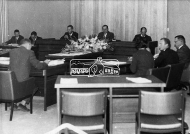
Photograph, Sunbury Regional Newspapers, Shire of Bulla, 15th July 1974
... on 15th July 1974 at the Old Shire Offices in Bulla. Council... on 15th July 1974 at the Old Shire Offices in Bulla. Council ...The men in the photograph are former councillors and they are at an ordinary meeting of the Shire of Bulla council, which took place on 15th July 1974 at the Old Shire Offices in Bulla. Council usually met at the Council Offices in Sunbury but there were times when they met at the Old Shire Offices in Bulla. The people are from L-R: M.Donovan, J.Watson (Deputy Shire Secretary), John Kelly (Shire secretary), C.E.Cook, J.P. (Shire President), John McKerrow ( Shire engineer), D.W.Dumbrell, A.V.Mitchell (Deputy Shire Engineer - Standing), J. Kelly, Eric Boardman (Regional News Gazette - Back to Camera) A non-digital black and white photograph with a cream border, of ten men seated around a table conducting a meeting in a room.Information about the event is filed with the photograph in the pocket.shire of bulla, old shire offices, bulla, councillors, council meetings -
Whitehorse Historical Society Inc.
Document, City of Nunawading. New Civic Offices, 1/03/1968 12:00:00 AM
... Program for the official opening of the new civic offices... for the official opening of the new civic offices and council chambers ...Program for the official opening of the new civic offices and council chambers of the City of Nunawading by the Hon R.J. Hamer, Minister for Local Government at 3 pm on 23 March 1968.Program for the official opening of the new civic offices and council chambers of the City of Nunawading by the Hon R.J. Hamer, Minister for Local Government at 3 pm on 23 March 1968.Program for the official opening of the new civic offices and council chambers of the City of Nunawading by the Hon R.J. Hamer, Minister for Local Government at 3 pm on 23 March 1968.city of nunawading, nunawading civic centre -
![Photograph - Digital image, Kelly Garden Supplies [Greensborough], 02/05/2013](/media/collectors/4f729f5697f83e03086015b8/items/5729bced2162f108e8de6b52/item-media/5729bd212162f108e8de74aa/item-fit-380x285.jpg) Greensborough Historical Society
Greensborough Historical SocietyPhotograph - Digital image, Kelly Garden Supplies [Greensborough], 02/05/2013
... Drive was associated with the building of Diamond Valley Council... of Diamond Valley Council Offices opened by Governor Rohan Delacombe ...This photograph of the former site of Kelly Garden Supplies was taken in 2013 to show changes over 40 years, based on Ron Reynold’s sketches in the 1973 publication “Greensborough and Greenhills” published by Cypress Books. The site is now part of the Civic roundabout at the top of the Greensborough By-pass. Civic Drive was associated with the building of Diamond Valley Council Offices opened by Governor Rohan Delacombe on 26/2/1972. Previously it was known as Kelly's Track which wound its way around to a house that overlooked the aqueduct bridge. Kelly's Sandpit (quarry) was the local go to place to obtain road, driveway fill and red sand for local construction. For 80 years previous Kelly's quarry supplied sand to the greater Melbourne area for the surfacing of school grounds, parks etc. Digital copy of colour photograph.greensborough and greenhills, civic drive greensborough, kelly garden supplies, ron reynolds -
Tatura Irrigation & Wartime Camps Museum
Entry Ticket, Shire Chambers Opening, 1968
... In 1968 the very old council chambers and offices in Casey... Tatura the-murray In 1968 the very old council chambers ...In 1968 the very old council chambers and offices in Casey Street were replaced on the same site by new buildings. The card admitted its holder to the Official Opening.small card with string attached acted as entry ticket to function - official opening of new Shire Chambers in 1968. Blue still cardboard.Shire of Rodney Official Opening. Municipal office and council chambers. 12 December 1968. Entree card cocktail party. Shire Presidents Suite 4.30 pm. This card must be presented.shire of rodney -
 Kew Historical Society Inc
Photograph - Construction of the Kew Civic Centre, 1972
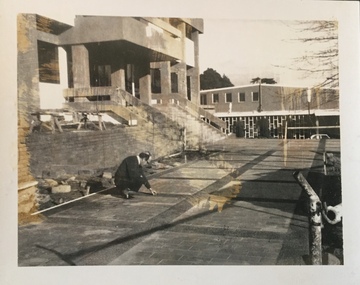
... Chamber and Council Offices in 1972. The Kew Library... Chamber and Council Offices in 1972. The Kew Library ...The Kew Civic Centre, as opposed to the adjacent Kew Civic Hall (see also Kew City Hall), was built to house a new Council Chamber and Council Offices in 1972. The Kew Library was to be located on the ground floor and accessed from the current carpark. This building replaced the former Town Hall in Walpole Street, Kew which had served as a town hall from 1865-1972. After the sale of the old Town Hall, the new Civic Centre was built to a design of the architects A K Lines, MacFarlane & Marshall. A fit-out of the building was still occurring when councillors and council officers moved into the building. In 1987, the Kew Library (and the Kew Historical Society) moved across the road to the reconfigured Civic Hall. The Civic Centre, pictured here, was ultimately sold to Trinity Grammar School following the amalgamation of Kew into the City of Boroondara.These four black and white photographs were taken by a photographer in the City Engineer's Department during the final construction phase. Each is dated and inscribed with a description.Laying of concrete tiles in the forecourt of the new Kew Civic Centre in 1972. The Civic Hall (now the Kew Library) is in the background. Annotated verso: "Civic Centre - Forecourt / 17.7.72"kew civic centre, kew civic offices, city of kew -- council chamber -
 Kew Historical Society Inc
Photograph - Construction of the Kew Civic Centre, 1972
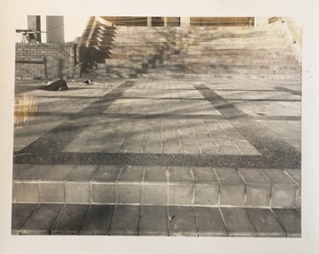
... Chamber and Council Offices in 1972. The Kew Library... Chamber and Council Offices in 1972. The Kew Library ...The Kew Civic Centre, as opposed to the adjacent Kew Civic Hall (see also Kew City Hall), was built to house a new Council Chamber and Council Offices in 1972. The Kew Library was to be located on the ground floor and accessed from the current carpark. This building replaced the former Town Hall in Walpole Street, Kew which had served as a town hall from 1865-1972. After the sale of the old Town Hall, the new Civic Centre was built to a design of the architects A K Lines, MacFarlane & Marshall. A fit-out of the building was still occurring when councillors and council officers moved into the building. In 1987, the Kew Library (and the Kew Historical Society) moved across the road to the reconfigured Civic Hall. The Civic Centre, pictured here, was ultimately sold to Trinity Grammar School following the amalgamation of Kew into the City of Boroondara.These four black and white photographs were taken by a photographer in the City Engineer's Department during the final construction phase. Each is dated and inscribed with a description.Forecourt of the new Kew Civic Centre in 1972.Annotated verso: "Civic Centre - Forecourt / 16.7.72"kew civic centre, kew civic offices, city of kew -- council chamber -
 Kew Historical Society Inc
Photograph - Construction of the Kew Civic Centre, 1972
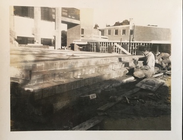
... Chamber and Council Offices in 1972. The Kew Library... Chamber and Council Offices in 1972. The Kew Library ...The Kew Civic Centre, as opposed to the adjacent Kew Civic Hall (see also Kew City Hall), was built to house a new Council Chamber and Council Offices in 1972. The Kew Library was to be located on the ground floor and accessed from the current carpark. This building replaced the former Town Hall in Walpole Street, Kew which had served as a town hall from 1865-1972. After the sale of the old Town Hall, the new Civic Centre was built to a design of the architects A K Lines, MacFarlane & Marshall. A fit-out of the building was still occurring when councillors and council officers moved into the building. In 1987, the Kew Library (and the Kew Historical Society) moved across the road to the reconfigured Civic Hall. The Civic Centre, pictured here, was ultimately sold to Trinity Grammar School following the amalgamation of Kew into the City of Boroondara.These four black and white photographs were taken by a photographer in the City Engineer's Department during the final construction phase. Each is dated and inscribed with a description.Tiling the steps leading from the forecourt to the new Kew Civic Centre in 1972.Annotated verso: "Civic Centre - Forecourt / 16.7.72"kew civic centre, kew civic offices, city of kew -- council chamber -
 Kew Historical Society Inc
Photograph - Construction of the Kew Civic Centre, 1972
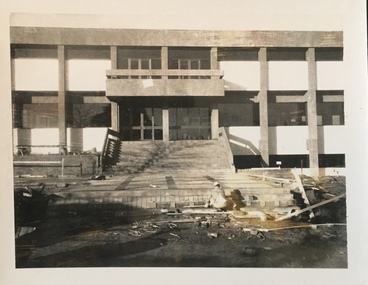
... Chamber and Council Offices in 1972. The Kew Library... Chamber and Council Offices in 1972. The Kew Library ...The Kew Civic Centre, as opposed to the adjacent Kew Civic Hall (see also Kew City Hall), was built to house a new Council Chamber and Council Offices in 1972. The Kew Library was to be located on the ground floor and accessed from the current carpark. This building replaced the former Town Hall in Walpole Street, Kew which had served as a town hall from 1865-1972. After the sale of the old Town Hall, the new Civic Centre was built to a design of the architects A K Lines, MacFarlane & Marshall. A fit-out of the building was still occurring when councillors and council officers moved into the building. In 1987, the Kew Library (and the Kew Historical Society) moved across the road to the reconfigured Civic Hall. The Civic Centre, pictured here, was ultimately sold to Trinity Grammar School following the amalgamation of Kew into the City of Boroondara.These four black and white photographs were taken by a photographer in the City Engineer's Department during the final construction phase. Each is dated and inscribed with a description.Creating the forecourt to the new Kew Civic Centre in 1972.Annotated verso: "Civic Centre - Forecourt / 16.7.72"kew civic centre, kew civic offices, city of kew -- council chamber