Showing 1723 items
matching county
-
 Federation University Historical Collection
Plan, Smythesdale, County of Grenville, 01/12/1892
This plan is associated with former Ballarat School of Mines Student Richard Squire (1875-1876). Gift of the Squire FamilyA plan showing the Borough of Smythesdale, Smythesdale, Browns and Scarsdale, allotments, water reserve, Timber reserve, Nintingbool Pre-emptive Right, Reserve for public gardens, Reserve for Cricket Ground, Reserve for Reservoirsmythesdale, scarsdale, browns, yarrowee, carngham, samuel barlett, sheridan, wrigley, p. land, r. simpson, d. davis, nintingbool, mclachlan, a. mclachlan, c. taylor, w. c. smith, d. davies, w. williams, m. jones, t. mcgurk, r. selkirk, a. mooney -
 Federation University Historical Collection
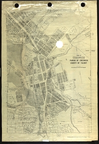
Plan, Creswick, Parish of Creswick, County of Talbot, 1928, 1928
Parish Plan of Creswick showing Slaty Creek, Old Gold Workings, Police Reserve, Railway Station, Public Gardens, Sawpit Gully, Hospital Reserve, Nigh Soil Depot, Eureka Terracotta Tile COmpany, Creswick Creek, Forest COmmission, Roycroft's Racecreswick, eureka terracotta tile co, parish plan -
 Federation University Historical Collection
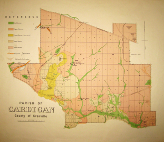
Map - Geological survey, Parish of Cardigan, County of Grenville, c1889
Geological map of the Parish of Cardigan on a cadastral base showing quartz reefs, shafts, alluvial deposits.cardigan, winter's creek, ballarat cattle yards railway, prince of wales park, ballarat, friendly societies reserve, ballarat industrial school reserve, green hill, bunker's hill, sago hill, diamond drill bores, cardigan propriety, half way house, ti tree creek, albion consols, prince imperial, winter's freehold company -
 Federation University Historical Collection
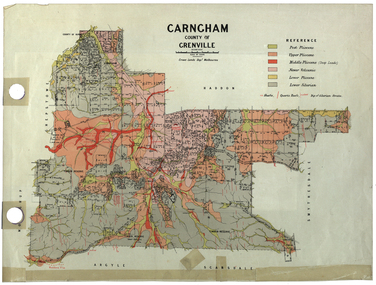
Plan, Carngham, County of Grenville
A plan of Carngham, Victoria.snake valley, timber reserve, poverty point, recreation reserve, carngham, county of ripon, county of grenville, plan -
 Federation University Historical Collection
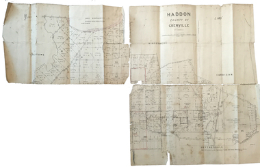
Plan, Haddon County of Grenville, 1887, 1887
Parish Plan of Haddon showing the township of Haddon, Cardigan and Haddon State Forest, Lake Burrumbeet and Nentingbook Pre-emptive Right. Names on the allotments include H. Cuthbert, B. Hepburn, T.W. Lloyd, J. Palmer, E.A. Wynne, William Collard Smith, A. Porteous, P. Russell, J. Mitchell, G. Renniehandwritten 'J. H. Cunningham Applic'haddon, cardigan, haddon state forest, lake burrumbeet, nentingbook pre-emptive right, h. cuthbert, b. hepburn, t.w. lloyd, j. palmer, e.a. wynne, william collard smith, a. porteous, p. russell, j. mitchell, g. rennie, j. noone, department of lands and survey -
 Federation University Historical Collection
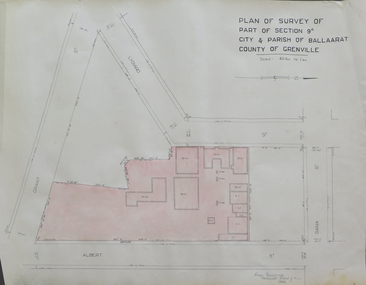
Plan, Plan of Survey of Part of Section 9A City & Parish of Ballarat County of Grenville (Albert Street frontage), 1932
The M.B. John Trade Building was built on the Albert Street Frontage..1) Plan of SMB showing Albert, Grant, Lydiard and Dana streets, on paper with colored highlights undertaken by Ballarat School of Mines student George Murrowood in 1932 .2) Hand written page by George Murrowood, of technical description of land surveying Grade II 1932ballarat school of mines, surveying, george murrowood, albert street, alumni, m.b. john building, architectural plan -
 Federation University Historical Collection
Plan, Parish of Dowling Forest, County of Ripon and Grenville, 19
Scale [1:31 680]. 40 chains to 1 in.Geological map on a cadastral base, showing the occurence of reefs, and alluvial deposits. Relief shown by contours.dowling forest, wyndholm, wyndholm pre-emptive right, miners rest, ballarat racecourse, winter's swamp, police reserve, miner's rest, winters swamp, geology -
 Federation University Historical Collection
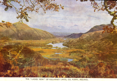
Postcard - colour, The "Ladies" View of Killarney Lakes, County Kerry, Ireland
A coloured depiction of the Killarney Lakes and the surrounding countryside.chatham-homes family collection, killarney, killarney lakes, county kerry, ireland -
 Federation University Historical Collection
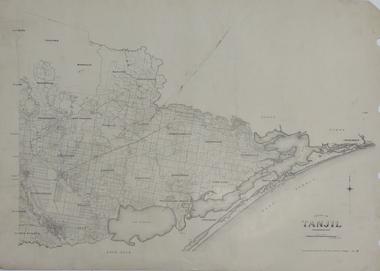
Map, County of Tanjil, 23/11/1906
Printed map on papertanjil -
 Federation University Historical Collection
Plan, Parish of Lal-Lal County of Grant
Printed colour map on paperlal lal, mt doran, lal lal racecourse, geology, geological, moorabool river, mount duran -
 Federation University Historical Collection
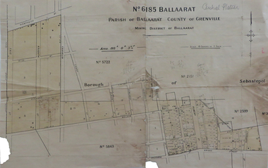
Map, No 6185 Ballaarat Parish of Ballaarat County of Grenville, not dated
Printed map with pencil inscriptionsmap, parish of ballaarat, grenville county, sebastopol, central company engine house, wesleyan reserve, victoria street, yarrowee street, charlotte st, kyle street -
 Federation University Historical Collection
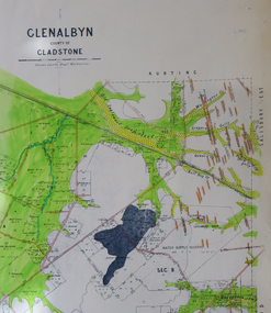
Map, Glenalbyn, County of Gladstone
Copy of a geological map of Glenalbyn. Some areas have been colours green. Creeks have been coloured blue, roads and reefs have been coloured orange.glenalbyn, county of gladstone, tarnagulla, inglewood, kingower, kurting, old inglewood deep lead, salisbury west -
 Federation University Historical Collection
Document, County Court Smythesdale, 1861-1862, 1861-1862
Blue Foolscap printed Government document on Smythesdale's Local Court.smythesdale, smythesdale county court, j. moore, county court -
 Ringwood and District Historical Society
Map, Plan of the Parish of Warrandyte County of Evelyn - 1841
Blueprint copy of Survey Map W27 detailing original Selectors' names and property locations between Yarra Yarra River (Warrandyte) and Mullum Mullum Creek (Ringwood). List of Parish map references including property bearings, distances in Links, and markings on trees. Pound Bend area of Warrandyte marked as Reserve For Aborigines. Descriptive remarks include areas marked "scrubby, flat, sandy soil". Several other references faded and illegible.(Map) by T.H. Nutt Feb 3 1841. -
 Yarra Ranges Regional Museum
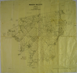
Map, H J Green, Acting Govt. Printer, Wandin Yallock, County of Evelyn (Parish Plan), c. 1910 - 1920
Parish Plan of Wandin Yallock. Location of Silvan Reservoir marked in ink on map.Parish Plan of Wandin Yallock. Location of Silvan Reservoir marked in ink on map. wandin yallock, maps -
Stawell Historical Society Inc
Map - Parish Map, Barkley County of Kara Kara 1920's, 1920's ?
Johnsons Gully LeadPaper map of Parish of BarkelyBy Authority H.J. Green Govt Printer. Photo Lithographed at the Department of Lands and Survey. Melbourne 22.11.2survey -
Stawell Historical Society Inc
Map, Lexington County of Borong 1910, 1910
Parish to the North East of MoystonA2 Parish mapPhoto Lithographed at the Department of Lands and Survey. Melbourne by T.F. McGauran 5.12.10survey -
Stawell Historical Society Inc
Map, T.F. McGauran, Winjallock County of Kara Kara, 1900
Noth of Navarre and BarkleyA2 Map0f Parish of Kara Kara.Photo Lithographed and the department of Lands & Survey, Melbourne by T.F. McCauran 22.10.00survey -
Stawell Historical Society Inc
Map - Parish Map, Department of Lands and Survey, Ashens County of Borung 1941, 1941
Murtoa Lake MarmaPaper Brown Coloured MapDrawn and Reproduced at the department of Lands and Survey Melbourne 1.5.1941survey -
Stawell Historical Society Inc
Map, Department of Lands & Survey J. Noone, Township of Heatherlie. Parish of Baroka. County of Borung 1888, 1888
Stawell & Grampians Freestone Quarry Company Railway Reserve. Cross & masons Quarry Site. Mamnager'sHouse, Stead's boarding House Stawell and Grampians railwaySurveyed Township Showing Quarry and railway Reservephoto Lithographed at the Department of lands and Survey Melbourne By J Noone 15.6.88railway quarry -
Whitehorse Historical Society Inc.
Map, Nunawading. County of Bourke, 1878
Photocopy of map of Shire of Nunawading.Photocopy of map of Shire of Nunawading. Note: Fosters v President of the Shire of Nunawading. On Verso: Copied from the most up to date by the Dept of Lands, 1878. Laid before the Executive Council, 11 June 1878. Shows land holders.Photocopy of map of Shire of Nunawading.shire of nunawading, maps -
Whitehorse Historical Society Inc.
Map, Directory Maps of the County of Bourke, 1892
Copies of Directory maps:(i) Title Page, (ii) Preface (iii) Heading section of Map of Melbourne and Suburbs (iv) Parish of Bulleen - includes 'North - East portion of the Parish of Nunawading (v) Village of Burwood. Note: 107(a), 107(b), 107(c) are copies of the same set of sheets.Copies of:(i) Title Page, (ii) Preface (iii) Heading section of Map of Melbourne and Suburbs (iv) Parish of Bulleen - includes 'North - East portion of the Parish of Nunawading (v) Village of Burwood. Note: 107(a), 107(b), 107(c) are copies of the same set of sheets.Copies of Directory maps:(i) Title Page, (ii) Preface (iii) Heading section of Map of Melbourne and Suburbs (iv) Parish of Bulleen - includes 'North - East portion of the Parish of Nunawading (v) Village of Burwood. Note: 107(a), 107(b), 107(c) are copies of the same set of sheets.maps, parish of bulleen, parish of nunawading, burwood -
 Ballarat Heritage Services
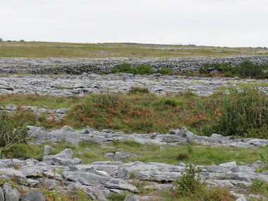
Photograph - Colour, The Burren, County Clare, near Ballyvaughan, 2016, 09/2016
the burren, county clare, ballyvaughan, ireland -
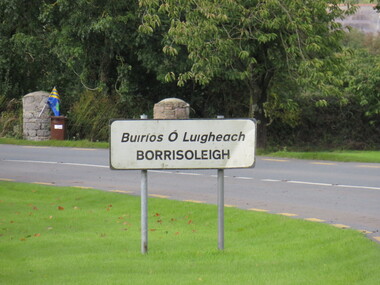 Ballarat Heritage Services
Photograph - Colour, Dorothy Wickham, Sign, Borrisoleigh, County Tipperary, Ireland, 2016, 09/2106
Borrisoleigh was the location from which the Quinane family and other Irish immigrants originated from. Nancy Quinane or Kinnane was one of these. Ann (Nancy) Quinane/Kinnane was baptised on 6 June 1830 at Upperchurch or Borrisoleigh, Tipperary, Ireland. She and her husband, Matthew Ryan, sailed from Liverpool to Australia on the Phoebe Dunbar in 1952. Nancy and Matthew Ryan lived on the Eureka Lead. in 1854. Matthew filed for compensation for his tent being burnt down during the Eureka Riots, the tent being inside the Eureka Stockade. Nancy, also known as Eureka Nancy, was present during the Eureka Stockade battle, and was said to have looked after the children. She is credited with assisting the amputation of Peter Lalor's Arm.borrisoleigh, tipperary, ireland, kinnane, quinane, ryan, matthew ryan, nancy quinane, eureka, eureka stockade, peter lalor -
 Ballarat Heritage Services
Photograph - Colour, Barravore Ford, County Wicklow, Ireland, 2016, 09/2016
The Connor family emigrated from Barrovore Ford, Ireland, to Australia around the 1860s. Remnants of their house are still extant near the ford. barravore ford, county wicklow, ireland, creek -
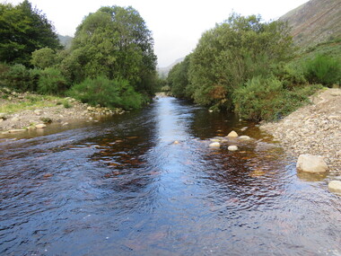
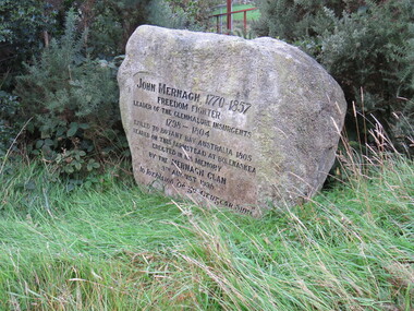 Ballarat Heritage Services
Photograph - Colour, Memorial Boulder to John Mernagh, Glenmalure, County Wicklow, Ireland
John Mernagh, 1770-1857, Freedom Fighter, Leader of the Glenmalure Insurgents 1798-1804, Exiled to Botany Bay Australia 1805, Erected in his memory by the Mernagh Clan 9th August 1998. In lothlainn oe go otuzcar sinn? (gaelic inscription) -
 Bayside Gallery - Bayside City Council Art & Heritage Collection
Map, Department of Crown Lands and Survey et al, Moorabbin, County of Bourke, Government Roads, 1920
The cadastral map of the Parish of Moorabbin in Victoria (L.6104) shows parish boundaries and land ownership 1920 when Sandringham was a Town. The government roads have been coloured in red pencil.moorabbin, county of bourke, map, plan, land subdivision, land titles, foreshores, hampton, beaumaris, highett, cheltenham, department of lands and survey, land owners, cartographic material, brighton, sandringham, town of sandringham, government roads -
 Bayside Gallery - Bayside City Council Art & Heritage Collection
Map, Department of Crown Lands and Survey, Moorabbin, County of Bourke, c. 1918
The cadastral map of the Parish of Moorabbin in Victoria (L.6104) shows parish boundaries and land ownership c. 1918 when Sandringham was a Borough.moorabbin, county of bourke, map, plan, land subdivision, land titles, foreshores, sndringham, hampton, beaumaris, highett, cheltenham, department of lands and survey, land owners, cartographic material, borough of sandringham, brighton -
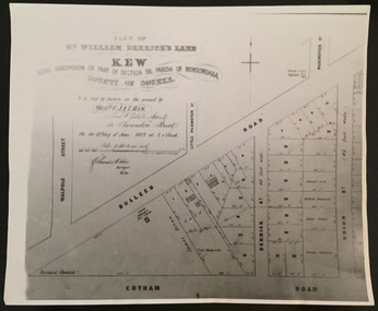 Kew Historical Society Inc
Print - Subdivision Plan, F Price, Plan of Mr William Derrick's Land, Kew being Subdivision of Part of Section 86, Parish of Boroondara, County of Bourke, 1872, 1872 [Original]
This work forms part of the collection assembled by the historian Dorothy Rogers, that was donated to the Kew Historical Society by her son John Rogers in 2015. The manuscripts, photographs, maps, and documents were sourced by her from both family and local collections or produced as references for her print publications. Many were directly used by Rogers in writing ‘Lovely Old Homes of Kew’ (1961) and 'A History of Kew' (1973), or the numerous articles on local history that she produced for suburban newspapers. Most of the photographs in the collection include detailed annotations in her hand.The Rogers Collection provides a comprehensive insight into the working habits of a historian in the 1960s and 1970s. Together it forms the largest privately-donated collection within the archives of the Kew Historical Society.A photographic reproduction of a plan in the Vale Collection of the State Library of Victoria showing William Derricks land in the area bordered by Bulleen Road (High Street); Cotham Road and Union Street. The plan dates from 1872.william derrick, subdivision plans -- kew (vic.) -
 Kew Historical Society Inc
Plan - Subdivision Plan, Plan of Subdivision of Part of Crown Portion 84 / Parish of Boroondara / County of Bourke / Lodged Plan No. 2217, Twentieth Century
Pru Sanderson, in her groundbreaking ‘City of Kew Urban Conservation Study : Volume 2 - Development History’ (1988), summarised the periods of urban development and subdivisions of land in Kew. The periods that she identified included 1845-1880, 1880-1893, 1893-1921, 1921-1933, 1933-1943, and Post-War Development. These periods were selected as they represented periods of rapid growth or decline in urban development. An obvious starting point for Sanderson’s groupings involved population growth and the associated economic cycles. These cycles also highlighted urban expansion onto land that was predominantly rural, although in other cases it represented the decline and breakup of large estates. A number of the plans in the Kew Historical Society’s collection can also be found in other collections, such as those of the State Library of Victoria and the Boroondara Library Service. A number are however unique to the collection.The Kew Historical Society collection includes almost 100 subdivision plans pertaining to suburbs of the City of Melbourne. Most of these are of Kew, Kew East or Studley Park, although a smaller number are plans of Camberwell, Deepdene, Balwyn and Hawthorn. It is believed that the majority of the plans were gifted to the Society by persons connected with the real estate firm - J. R. Mathers and McMillan, 136 Cotham Road, Kew. The Plans in the collection are rarely in pristine form, being working plans on which the agent would write notes and record lots sold and the prices of these. The subdivision plans are historically significant examples of the growth of urban Melbourne from the beginning of the 20th Century up until the 1980s. A number of the plans are double-sided and often include a photograph on the reverse. A number of the latter are by noted photographers such as J.E. Barnes.Undated Plan of Subdivision of Crown Portion 84 in what is now Kew. The area shown is bordered by Burke Road, Harp Road, Arglye Road and Normanby Road.subdivision plans -- kew (vic), harp road, burke road, normanby road, lady loch's drive, gladstone street, second avenue, first avenue