Showing 13105 items matching "development/redevelopment"
-
 Stawell Historical Society Inc
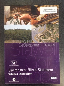
Book, Resource Strategies Pty Ltd, The Big Hill Development Project - Environmental Effects Statement - Main Report, 1999
Enviromental Effects statement for the Stawell Gold Mine.Purple card cover with four colour photos in top halfThe Big Hil Development Project. Stawell Gold Mines Victoria Environment Effects Statement Volume 1 Main Report Resources Strategiesstawell gold mining -
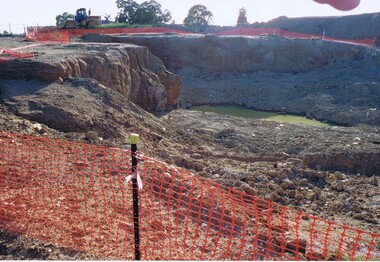
![Document collection, Watsonia development [Lambourn and Devonshire Roads], 2019_](/media/collectors/4f729f5697f83e03086015b8/items/5d82cea121ea6712b80a7cdd/item-media/5d8579dd21ea67168c696120/item-fit-380x285.jpg) Greensborough Historical Society
Greensborough Historical SocietyDocument collection, Watsonia development [Lambourn and Devonshire Roads], 2019_
In 2003, a proposal for a 5 storey building on the corner of Lambourn and Devonshire Roads Watsonia for an apartment complex, medical centre, shops and cafe was approved by VCAT, despite strong opposition by local residents. The proposal did not proceed. In 2019 a proposal for a 2 storey medical centre, cafe and residence was approved for the site and construction commenced. Collection of documents comprising history of development proposals by Rosie Bray, concept illustrations, archtect's plans, photograph and copy of newspaper clipping.watsonia, lambourn road watsonia, devonshire road watsonia -
 Lakes Entrance Historical Society
Book, Telecom Australia, The Palace of Winged Words. The development of Telephone Exchanges in Australia, 1980
An account of the development of Australias Telephone Exchanges from the first one established in Melbourne in August 1880 to the national and international service as at 1980communications -
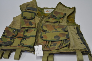 Wangaratta RSL Sub Branch
Uniform - Camouflage Vest, c1983
Australian Army camouflage vest manufactured at the Engineering Development Establishment in Maribyrnong prior to closureGreen and brown camouflage cloth and net vest with six pockets - three down either side of front zip. Seven braided loops around bottom of vest.webbing, australian army -
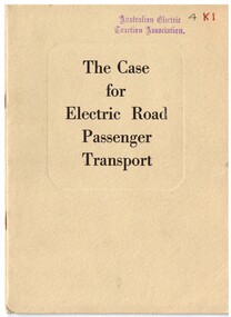 Melbourne Tram Museum
Book, British Electrical Development Association, "The Case for Electric Road Passenger Transport", early 1950's
Booklet - 20 pages, printed on off white paper, centre stapled within a grey cover slightly larger than the printed document, titled "The Case for Electric Road Passenger Transport". The title is printed on both document covers. The title is contained within a embossed area on the grey cover. The document looks at the case for electric transport in road use, both trolley buses and trams, current developments, including PCC cars, traffic problems, Europe, financial, passengers, reserved track, health and cleanliness. Not date, early 1950's? - has a reference to a 1951 public transport conference on page 5. On the rear page states "Issued by the British Electrical Development Association" of London."4K1" in ink on front cover and AETA stamp top of cover. AETA stamp and PR Officer 14 Kenaway St, Tusmore F3111" (Tusmore is in Adelaide).trams, tramways, public transport, uk, electrical equipment, electric vehicles, trolley buses, trams, pcc -
Port Melbourne Historical & Preservation Society
Negative - Negative, Barak Road Development Area Services plan, City of Port Melbourne, City of Port Melbourne, Barak Road Development Area Services, 27 Sep 1971
4" x 5" negative of City of Port Melbourne plan, Sept 1971, of services required for development between Barak and Beacon Roadstransport - railways, town planning, local government - city of port melbourne -
Whitehorse Historical Society Inc.
Document, Eastern Corridor Road Development, 1/09/1986 12:00:00 AM
Ministry of Transport Bulletins about development of Eastern Corridor RoadMinistry of Transport Bulletins about development of Eastern Corridor Road - Doncaster to Ringwood. Holdings: No 1 September 1986; no.3 June 1987.Ministry of Transport Bulletins about development of Eastern Corridor Roadroads and streets, eastern freeway, victoria. ministry of transport, mullum mullum creek -
Whitehorse Historical Society Inc.
Newspaper - Article, Mitcham halls make way for shopping development, 27/11/1985
Article from Nunawading Gazette re the demolition of the Mitcham Guide Hall and a weatherboard house to make way for Mitcham shopping centre development.commercial development, mitcham guide hall -
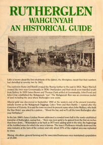 Rutherglen Historical Society
Pamphlet, Rutherglen Development Association, Rutherglen Wahgunyah: An Historical Guide, 1970s
Tourist brochure produced in the late 1970s by the Rutherglen Development Association with the assistance of Rutherglen Shire and Rutherglen Historical AssociationBrochure on A3 paper, folded in quarters, on pale yellow paper. Includes photographs, maps and a food and accommodation guide.rutherglen, wahgunyah, history, tourism -
Ringwood and District Historical Society
Envelope, Packet: Ringwood Town Planning, Incl Health Plan, Shops, Development, 1940-1992, 944-1946
Town Planning - Ringwood (Packet 1 of 2); Shops, Plans, C.R.B.; Costs, Future development; M.M.B.W.; Essays (Children); Includes health plan -
University of Melbourne, Burnley Campus Archives
Document, Land & Water Resources Research & Development Corporation, 1999-2000
land and water resources development research, ruth beilin -
 Mont De Lancey
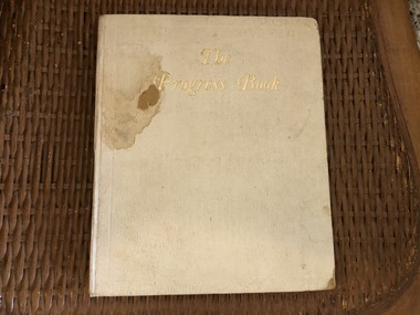
Book, Leadenhall Press Ltd, The Progress Book an Illustrated Register of The Development of A Child, 1911
Donated by Glenda (Sebire) McLeod, daughter of Mervyn Sebire.Cream hardback book "The Progress Book an Illustrated Register of the Development of a Child". Author J.J. Pilley Ph.D. The title is written in gold lettering at the top.books, children -
Lakes Entrance Historical Society
Book, LERHS members, Foreshore Development, 2002
A folder of clippings from local newspapers showing the development of the foreshore to enhance the landscape and provide recreation areas for the general public Lakes Entrance Victoriajetties, coast, environment -
 Bendigo Military Museum
Administrative record - Trilateration with the Tellurometer - GRL Rimington 1958, Department of National Development , ACT, 26 May 1958
trilateration with the tellurometer by GRL Rimington L.S MIS (Aust) Chief Topographic Surveyor, Department of National Development, Australia. This paper was delivered to the Institute of Surveyors Conference, Brisbane 26 May 1958. This paper is a summary of Electronic distance measurements carried out in 1957 in Central Australia by officers of the division of National Mapping, Department of National Development. Trilateration is a surveying Technique that uses measurements of the sides of triangles to determine relative position.A 11 page foolscap size stapled paper report. Two holed punched with dis-coloured pages due to age.royal australian survey corps, rasvy, fortuna, army survey regiment, army svy regt, asr, division of national mapping, surveying -
Federation University Historical Collection
Photograph, Ballarat Arts Academy Development Appeal Launch, 12/2001
Launch of the Camp Street Arts Academy Development Appeal. .1) Left to right: Cr David Vendy, Vice Chancellor Kerry Cox, Bill Pryor.arts academy development appeal, arts academy, camp street, david vendy, kerry cox, bill pryor -
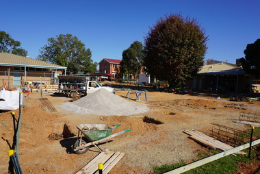 Galen Catholic College
Galen Resource Centre Building Development, 2017
2017 was a busy year for building and redevelopment at Galen Catholic College. This sequence of photos shows the progressive construction of the Galen Resource Centre, which housed the new Galen Library and the IT Assistance Hub. The new Galen Library replaced the original library building that was constructed in 1972 and enlarged in 1994.galen catholic college, galen college, galen resource centre, liibrary, it office, school buildings, school grounds & buildings, 2017 -
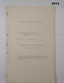
Federation University Historical Collection
Booklet - Report, Proposals for the Development of The Lydiard Street Site of the School of Mines and Industries, Ballarat, 1974, 20/11/1974
The report includes an organisational diagram, general aims, facilities, estimated floor areas.Twenty eight page typed report of proposals for the Development of the SMB campus, and a proposed title for the College "Ballarat Regional College". There is also a page on the advantages of student residential accommodation.smb campus, campus plans, ballarat regional college, ballarat school of mines lydiard street, gardens, library, student accomodation -
Clunes Museum
Booklet - PROPOSAL, CLUNES HISTORIC POLICE BUILDINGS - THEIR DEVELOPMENT AND MANAGEMENT AS AN INTERPRETIVE DISPLAY
CLEAR COVER, BLACK PLASTIC FOR BACK COVER , 18 PAGES CONTENTS OUTLINE A PROPOSAL FOR DEVELOPMENT AND MANAGMENT OF CLUNES HISTORIC POLICE BUILDINGS AS AN INTERPRETIVE DISPLAY. AUGUST 2000DONE BY R.COVEY, D. ROGERS, J.SAYERSclunes historic police buildings, police buildings, r.covey, d.rogers, j.sayers -
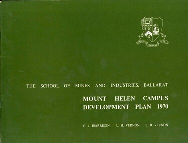 Federation University Historical Collection
Book, Mount Helen campus Development Plan 1970, 1970
Green and white soft covered booklet of 48 pages. SMB Crest is on the front cover. The content include the Mt Helen site, site planning, student residences, sporting facilities, roads and parking, pedestrian circulation, engineering services, and landscaping. Illustrations include: Plan of Mt Helen Site (July 1969, existing buildings, Functional relationship, Roads and Parking, Pedestrian Circulation, engineering Services, Landscaping, Development Plan, Plan of Academic area, Library and union Courtyards, Birds Eye View of Academic Area from north-west, etc. the master plan projects student numbers.non-fictionuniversity of ballarat, ballarat institute of advanced education, mount helen, master plan, landscape, harrison, vernon, great hall, geoff harrison, john vernon, m.b. john, contour map, student accomodation, landscaping, development plan, campus plan -
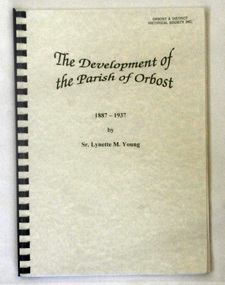 Orbost & District Historical Society
book, Young, Sister Lynette, The Development of the Parish of Orbost, November 1980
Sister Lynette Young was born in Orbost and lived there all her life until 18 when she went to Teachers’ College in Melbourne. This study was produced for partial fulfillment of the requirements of Church History 111 in the degree of Bachelor of Theology in the Melbourne College of Divinity at the affiliated teaching institution, Catholic Theological College in November 1980.This is a local history book written by a local author. It is a useful research tool.A 65 pp spiral bound book with a pale green cover. It is titled The Development of the Parish of Orbost 1887-1937. The title is in black. The book was written by Sister Lynette M. Young.Autographed by Sister Lynette Young.church-history-catholic orbost-history catholic-theological-college -
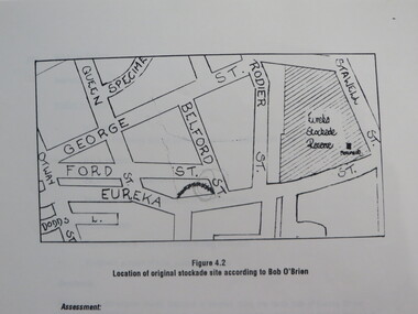 Federation University Historical Collection
Report, Concept Study for the Further Development of the Eureka Stockade Reserve Conservation Plan, Vol 3, c1992
The objectives of the study were to * gather historical data and confirm the cultural significance of the site and reserve. * review existing site conditions including ownership together with current and proposed land uses. * Eureka Stockade location Copy of a 38 page report called "Concept Study for the Further Development of the Eureka Stockade Reserve Conservation Plan Vol 3", published by Ballarat University College. Authors are not stated. eureka, eureka stockade, ballarat university college, bert strange, bob o'brien, weston bate, alec barnett, jack chisholm, lloyd jenkins, eureka stockade location, cultural significance, eureka stockade site -
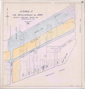 Ringwood and District Historical Society
Map, Development of Right of Way Stage 2, Ringwood, Victoria - 1950
Borough Engineer's technical drawing for Development of Right of Way between Adelaide Street and Warrandyte Road, Ringwood, showing existing retail establishments and outbuildings, and area available for lock-up shops.Scale 20' = 1". ACR 11.7.50. (Alan Charles Robertson - Borough Engineer) -
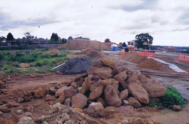 Greensborough Historical Society
Photograph - Digital image, Frank Solomon, Development of pig farm to residential blocks, 1, 02/08/2009
A view of the redevelopment of the pig farm in Weidlich Road Greensborough, owned by Werner Hanusch. The land was used as a pig farm and quarry from 1954 and this photo shows early stages of the land being subdivided into the Evelyn Way estate. This project of fifty, one double storey, dwellings was commenced on 2/8/2009 and completed on 6/2/2011.An example of the changing land use in Greensborough, from farming to residential.Digital copy of colour photographwerner otto fritz hanusch, pig farm st helena, weidlich road greensborough, one evelyn way greensborough -
 Greensborough Historical Society
Photograph - Digital image, Frank Solomon, Development of pig farm to residential blocks, 2, 02/08/2009
A view of the redevelopment of the pig farm in Weidlich Road Greensborough, owned by Werner Hanusch. The land was used as a pig farm and quarry from 1954 and this photo shows early stages of the land being subdivided into the Evelyn Way estate. This project of fifty, one double storey, dwellings was commenced on 2/8/2009 and completed on 6/2/2011.An example of the changing land use in Greensborough, from farming to residential.Digital copy of colour photographwerner otto fritz hanusch, pig farm st helena, weidlich road greensborough, one evelyn way greensborough -
 Greensborough Historical Society
Photograph - Digital image, Frank Solomon, Development of pig farm to residential blocks, 3, 02/08/2009
A view of the redevelopment of the pig farm in Weidlich Road Greensborough, owned by Werner Hanusch. The land was used as a pig farm and quarry from 1954 and this photo shows early stages of the land being subdivided into the Evelyn Way estate. This project of fifty, one double storey, dwellings was commenced on 2/8/2009 and completed on 6/2/2011.An example of the changing land use in Greensborough, from farming to residential.Digital copy of colour photographwerner otto fritz hanusch, pig farm st helena, weidlich road greensborough, one evelyn way greensborough -
 Greensborough Historical Society
Photograph - Digital image, Frank Solomon, Development of pig farm to residential blocks, 4, 02/08/2009
A view of the redevelopment of the pig farm in Weidlich Road Greensborough, owned by Werner Hanusch. The land was used as a pig farm and quarry from 1954 and this photo shows early stages of the land being subdivided into the Evelyn Way estate. This project of fifty, one double storey, dwellings was commenced on 2/8/2009 and completed on 6/2/2011.An example of the changing land use in Greensborough, from farming to residential.Digital copy of colour photographwerner otto fritz hanusch, pig farm st helena, weidlich road greensborough, one evelyn way greensborough -
 Greensborough Historical Society
Photograph - Digital image, Frank Solomon, Development of pig farm to residential blocks, 5, 02/08/2009
A view of the redevelopment of the pig farm in Weidlich Road Greensborough, owned by Werner Hanusch. The land was used as a pig farm and quarry from 1954 and this photo shows early stages of the land being subdivided into the Evelyn Way estate. This project of fifty, one double storey, dwellings was commenced on 2/8/2009 and completed on 6/2/2011.An example of the changing land use in Greensborough, from farming to residential.Digital copy of colour photographwerner otto fritz hanusch, pig farm st helena, weidlich road greensborough, one evelyn way greensborough -
Kew Historical Society Inc
Archive (Sub-series) - Subject File, Development (Kew), 1958
Various partiesReference, Research, InformationSecondary Values (KHS Imposed Order)Subject file consisting largely of newspaper clippings/articles relating to houses in Kew. The earliest original newspaper article dates from 1923 and relates to housing shortages. The file contains some interesting Council records and correspondence relating to community action in response to development. These include the proposed lease of the Ground Floor of the Kew Civic Buildings as a postal delivery centre (1992), the development of flats in Studley Ward (1977), a proposed motel in Studley Park Road (1983)kew post office, heritage, planning and developmentkew post office, heritage, planning and development -
 Melbourne Tram Museum
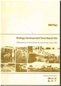
Document - Report, Ministry of Transport, "METRAS - Strategy Development Final Report M4 - Metropolitan Arterial Road Access Study, May. 1986
Report - 198 pages - perfect bound +card covers + fold out maps and charts, looks at the development of arterial roads in the various Melbourne regions, includes recommendations, funding, Punt Road, management. Has table of contents, diagrams and maps. Includes findings of the studies, issues with freight transport, improvement proposals. Little work on public transport as such. Title - "METRAS - Strategy Development Final Report M4 - Metropolitan Arterial Road Access Study - May 1986"has pen marks alongside some paragraphs or underneath headings in the recommendations section.trams, tramways, public transport, road transport, minister for transport -
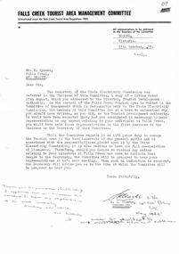 Falls Creek Historical Society
Letter - Re Letter To Tourist Development Authority
Bob Hymans Collection Bob (Herman) Hymans (a former member of the Royal Netherlands Navy was born in Bloemendaal, Holland on 30th September 1922. During World War II he fought against the Japanese in the Dutch East Indies (now Indonesia) and was imprisoned in Changi and on the Burma Railway. After gaining qualifications as a Ski Instructor, Bob arrived in Falls Creek in May 1950. Working as an Instructor and Supervisor at Bogong Lodge, Bob decided his future was in accommodation. He was successful in negotiating an indenture for land from the State Electricity Commission (SEC). It took Bob two years to build his Grande Coeur Chalet but, tragically, it was burned down in August 1961. Bob also built the first Chairlift in Australia. This was a single chairlift and the structure was built from wooden electricity poles. He was constantly full of new ideas and proposals for the village. Bob Hymans died on 7th July 2007. This Collection of documents and letters tells the story of Bob’s endeavours to develop Falls Creek into the ski village it is today.This document is significant because it documents the Rules of Falls Creek Tourist Area Regulations 1959.A letter from the Falls Creek Tourist Area Management Committee in response to Bob Hymans having written directly to the Tourist Development Authority. This was viewed as Bob Hymans not following correct communication protocols.bob hymans, falls creek tourist development authority protocols