Showing 338 items
matching diamond creek valley
-
 Greensborough Historical Society
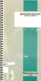
Booklet, Wilson Sayer Core Pty Ltd, Diamond Creek retail study: preparation of development concept options, August 1989
... retail development in Diamond Creek 1989. diamond creek shire ...Planning options for an extended retail development in Diamond Creek 1989.12 p. text, 12p. plans, spiral bound non-fictiondiamond creek, shire of diamond valley, retail developments -
 Greensborough Historical Society
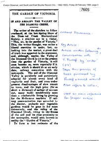
Newspaper - Newspaper Clipping (copy), Evelyn Observer and South East Bourke Record, The Garden of Victoria; in and around the valley of the Diamond Creek, 1890, 28/02/1890
... Diamond Creek, 1890....; in and around the valley of the Diamond Creek, 1890. Newspaper Newspaper ...An historical article on the Batman Apple Tree written in 1890. The Batman Apple tree is said to be over 170 years old, being brought to Greensborough in the 1840s from the Melbourne orchard of John Batman, following Batman's death in 1839. 5 page copy of newspaper article, text.Handwritten notes by Anne Paul.batman apple tree, robert whatmough, plenty river trail, flintoff family -
 Greensborough Historical Society
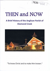
Booklet, Nillumbik Historical Society, Then and now: a brief history of the Anglican Parish of Diamond Creek, 22/10/2019
A history of the Anglican Parish of Diamond Creek, prepared for the Yarra Plenty Regional Library's "Diamond Valley History Tour 2019". The Diamond Creek parish includes St John's Diamond Creek, St Michael's Yarrambat and St Katherine's St Helena.Booklet, 8 pages, text and colour illus.diamond valley, yarra plenty regional library, anglican parish of diamond creek, st john's diamond creek, st katherine's st helena, st michael's yarrambat -
 Greensborough Historical Society
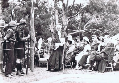
Photograph, Cr Jessop opens a venue in Diamond Creek
... by the Shire of Diamond Valley in 1979. diamond creek cecil jessop ...This undated photograph shows Councillor Cecil Jessop, as Mayor of Heidelberg, opening a venue in Diamond Creek, possibly a pool. Photographed b G. Cox, this photograph appeared in the Diamond Valley Story, published by the Shire of Diamond Valley in 1979.Large black and white photograph of a group of people at an official event.diamond creek, cecil jessop, shire of diamond valley -
 Greensborough Historical Society
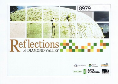
Postcard, Reflections of Diamond Valley, 1979
This postcard depicts the Diamond Creek Community Centre (Bini Shell) during its construction in 1979. It is part of the YPRL image collection. Colour postcardyarra plenty regional library, arts victoria, diamond creek, bini shell diamond creek -
 Greensborough Historical Society
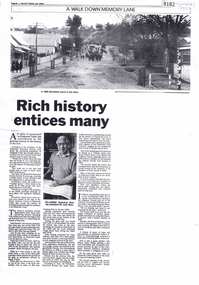
Newspaper - Newspaper Clipping (copy), Valley Views, Rich history entices many, 1992_07
In this article, Nillumbik Historical Society President Jock Ryan (1992) discusses why people might join an historical society, how his interest in Diamond Creek history evolved and information on the history of the area. Photocopy of newspaper article, 1 page, black and white image.jock ryan, nillumbik historical society, diamond creek -
 Greensborough Historical Society
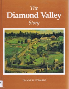
Book, The Diamond Valley Story by Dianne H Edwards, 1979_
... of early life in Diamond Valley. greensborough eltham diamond creek ...History of the Shire of Diamond Valley from 1830-1964. This book is significant to the history of the area. It contains many historic photographs and details of early life in Diamond Valley. 191p., hard cover, illus. 5 copies. First edition has seperate index; index printed in book in 1995 reprint. greensborough, eltham, diamond creek, watsonia, hurstbridge, wattle glen -
 Greensborough Historical Society
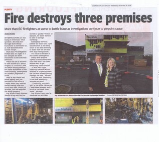
Newspaper Clipping, Diamond Valley Leader, Fire destroys three premises, 28/11/2018
Investigators are still trying to determine what sparked a fire that tore through three Plenty businesses on November 17, as staff described their narrow escape.News article 1 page, black text and colour image .plenty fire, ray white plenty, diamond creek road greensborough -
 Greensborough Historical Society
Map, Melbourne and Metropolitan Board of Works. Survey Division, MMBW, Yarra 2500 / 13.21. Central Greensborough, 1979_05
Melbourne and Metropolitan Board of Works. Yarra 2500 [base map]. 13-21, Parishes of Keelbundora 2856 and Nillumbik 3310, Municipality of Diamond Valley 257. Shows street names, easement sizes, lot numbers, lodged plan numbers, names of prominent features, contour values, creek or river names. Central Greensborough. Prominent streets: Main Street, Para Road, St Helena Road and Diamond Creek Road.MMBW Map in 1:2500 [scale] series. Cream parchment with green tape reinforcing on edges and punched holes on left edge.mmbw, melbourne and metropolitan board of works, shire of diamond valley, greensborough - maps -
 Greensborough Historical Society
Map, Melbourne and Metropolitan Board of Works. Survey Division, MMBW, Yarra 2500 / 12.20. Watsonia Railway Station and environs, 1983_03
Melbourne and Metropolitan Board of Works. Yarra 2500 [base map]. 12-20, Parishes of Keelbundora 2856, Municipalities of Diamond Valley 257 and 228. Shows street names, easement sizes, lot numbers, lodged plan numbers, names of prominent features, contour values, creek or river names. Watsonia Railway Station and environs. Prominent streets: Watsonia Road, Elder Street, Morwell Avenue and Nepean Street. Includes former Watsonia Technical School and Gresswell Rehabilitation Centre sites.MMBW Map in 1:2500 [scale] series. Cream parchment with green tape reinforcing on edges and punched holes on left edge.mmbw, melbourne and metropolitan board of works, shire of diamond valley, watsonia - maps -
 Greensborough Historical Society
Map, Melbourne and Metropolitan Board of Works. Survey Division, MMBW, Yarra 2500 / 12.19. Watsonia, Simpson Army Barracks, 1983_03
Melbourne and Metropolitan Board of Works. Yarra 2500 [base map]. 12-19, Parish of Keelbundora 2856, Municipalities of Diamond Valley 257 and 228. Shows street names, easement sizes, lot numbers, lodged plan numbers, names of prominent features, contour values, creek or river names. Watsonia Barracks (Simpson Army Barracks) and environs. Prominent streets: Yallambie Road, Greensborough Road, and Strathallan Road. MMBW Map in 1:2500 [scale] series. Cream parchment with green tape reinforcing on edges and punched holes on left edge.mmbw, melbourne and metropolitan board of works, shire of diamond valley, watsonia - maps -
 Greensborough Historical Society
Map, Melbourne and Metropolitan Board of Works. Survey Division, MMBW, Yarra 2500 / 12.22. Watsonia North, 1978_03
Melbourne and Metropolitan Board of Works. Yarra 2500 [base map]. 12-22, Parishes of Keelbundora 2856, Municipalities of Whittlesea 239 and Diamond Valley 257. Shows street names, easement sizes, lot numbers, lodged plan numbers, names of prominent features, contour values, creek or river names. Watsonia Railway Station and environs. Prominent streets: Edmund Rice Parade and Macorna Street. Includes Christian Brothers Edmund Rice College and Janefield Special School sites and "proposed future freeway" (now Metropolitan Ring Road).MMBW Map in 1:2500 [scale] series. Cream parchment with green tape reinforcing on edges and punched holes on left edge.mmbw, melbourne and metropolitan board of works, shire of diamond valley, watsonia - maps, bundoora - maps -
 Greensborough Historical Society
Map, Melbourne and Metropolitan Board of Works. Survey Division, MMBW, Yarra 2500 / 12.21. Watsonia North, 1979_02
Melbourne and Metropolitan Board of Works. Yarra 2500 [base map]. 12-22, Parish of Keelbundora 2856, Municipality of Diamond Valley 257. Shows street names, easement sizes, lot numbers, lodged plan numbers, names of prominent features, contour values, creek or river names. Watsonia Railway Station and environs. Prominent streets: Grimshaw Street, William Street and Macorna Street. Includes former Institute of Social Welfare (now Loyola College) Lines Reserve and Binnak Park.MMBW Map in 1:2500 [scale] series. Cream parchment with green tape reinforcing on edges and punched holes on left edge.mmbw, melbourne and metropolitan board of works, shire of diamond valley, watsonia - maps, bundoora - maps -
 Greensborough Historical Society
Map, Melbourne and Metropolitan Board of Works. Survey Division, MMBW, Yarra 2500 / 12.24. Plenty and Blue Lake, 1977_10
Melbourne and Metropolitan Board of Works. Yarra 2500 [base map]. 12-24, Municipalities of Whittlesea 239 and Diamond Valley 257. Shows street names, easement sizes, lot numbers, lodged plan numbers, names of prominent features, contour values, creek or river names. Watsonia Railway Station and environs. Prominent streets: Memorial Drive. Includes Plenty River and Blue Lake in the Plenty Gorge.MMBW Map in 1:2500 [scale] series. Cream parchment with green tape reinforcing on edges and punched holes on left edge.mmbw, melbourne and metropolitan board of works, shire of diamond valley, plenty - maps, blue lake -
 Greensborough Historical Society
Map, Melbourne and Metropolitan Board of Works. Survey Division, MMBW, Yarra 2500 / 13.22. Greensborough, Apollo Parkways, 1979_06
Melbourne and Metropolitan Board of Works. Yarra 2500 [base map] 13-22. Greensborough, Apollo Parkways. Parishes of Nillumbik 3310 and Keelbundora 2856. Municipalities of Diamond Valley 257 and Whittlesea 239. Prominent streets include: Plenty River Drive, Diamond Creek Road and Civic Drive. Includes Diamond Valley Civi Centre, Churinga, Janefield Colony Reserve and "proposed freeway" now Greensborough Highway (Bypass)MMBW Map in 1:2500 [scale] series. Cream parchment with green tape reinforcing on edges and punched holes on left edge.mmbw, melbourne and metropolitan board of works, shire of diamond valley, greensborough - maps, apollo parkways - maps -
 Greensborough Historical Society
Map, Melbourne and Metropolitan Board of Works. Survey Division, MMBW, Yarra 2500 / 17.27. Central Hurstbridge, 1978_02
Melbourne and Metropolitan Board of Works. Yarra 2500 [base map] 17-27. Central Hurstbridge. Parish of Greensborough 2724, Municipalities of Diamond Valley 257, Eltham 238 and Whittlesea 239. Prominent streets include: Anzac Avenue and Hurstbridge-Arthurs Creek Road. MMBW Map in 1:2500 [scale] series. Cream parchment with green tape reinforcing on edges and punched holes on left edge.mmbw, melbourne and metropolitan board of works, shire of diamond valley, hurstbridge - maps -
 Greensborough Historical Society
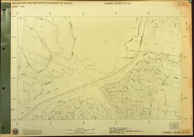
Map, Melbourne and Metropolitan Board of Works. Survey Division, MMBW, Yarra 2500 / 16.24. Northern Diamond Creek and Wattle Glen, 1978_02
... of diamond valley wattle glen - maps diamond creek - maps MMBW Map ...Melbourne and Metropolitan Board of Works. Yarra 2500 [base map] 16-24. Northern Diamond Creek and Wattle Glen. Parishes of Nillumbik 3310 and Greensborough 2724. Municipalities of Diamond Valley 257 and Eltham 238. Prominent streets include: Hurstbridge Road, and Reynolds Road. Includes Wattle Glen Station.MMBW Map in 1:2500 [scale] series. Cream parchment with green tape reinforcing on edges and punched holes on left edge.mmbw, melbourne and metropolitan board of works, shire of diamond valley, wattle glen - maps, diamond creek - maps -
 Greensborough Historical Society
Map, Melbourne and Metropolitan Board of Works. Survey Division, MMBW, Yarra 2500 / 16.23. Diamond Creek, 1978_02
... valley diamond creek - maps MMBW Map in 1:2500 [scale] series ...Melbourne and Metropolitan Board of Works. Yarra 2500 [base map] 16-23. Diamond Creek. Parish of Nillumbik 3310. Municipalities of Diamond Valley 257 and Eltham 238. Prominent streets include: Phipps Crescent, Bishop Avenue, and Reynolds Road. Includes the former Diamond Creek Technical School.MMBW Map in 1:2500 [scale] series. Cream parchment with green tape reinforcing on edges and punched holes on left edge.mmbw, melbourne and metropolitan board of works, shire of diamond valley, diamond creek - maps -
 Greensborough Historical Society
Map, Melbourne and Metropolitan Board of Works. Survey Division, MMBW, Yarra 2500 / 16.22. Research, 1979_05
... of Nillumbik 3310. Municipalities of Diamond Valley 257 and Eltham 238 ...Melbourne and Metropolitan Board of Works. Yarra 2500 [base map] 16-22. Research. Parish of Nillumbik 3310. Municipalities of Diamond Valley 257 and Eltham 238. Prominent streets include: Orme Road and Allendale Road. MMBW Map in 1:2500 [scale] series. Cream parchment with green tape reinforcing on edges and punched holes on left edge.mmbw, melbourne and metropolitan board of works, shire of diamond valley, diamond creek - maps -
 Greensborough Historical Society
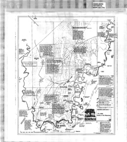
Map, Heidelberg: Historic River Landscape Assessment, Historical Maps. Map A To 1838. Country of the Wawarang, 1985c
Geographical area of around 35 sq. kilometres marked with physical features such as major roads, rivers, vegetation and properties, with contemporary notes on landowners, descriptions and comments on the land and its development. Bounded by Shire of Diamond Valley to the North, Darebin Creek to the West and Plenty River to the East.Black an white sketch map on white paperheidelberg, heidelberg - maps -
 Greensborough Historical Society
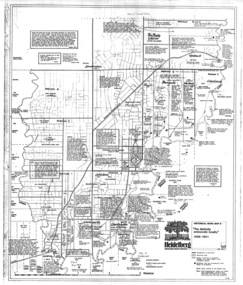
Map, Heidelberg: Historic River Landscape Assessment. Historical Maps. Map B 1838-1851, "The Distinctly aristocratic locality", 1985c
Geographical area of around 35 sq. kilometres marked with physical features such as major roads, rivers, vegetation and properties, with contemporary notes on landowners, descriptions and comments on the land and its development. Bounded by Shire of Diamond Valley to the North, Darebin Creek to the West and Plenty River to the EastBlack and white sketch map on white paperheidelberg, heidelberg - maps -
 Greensborough Historical Society
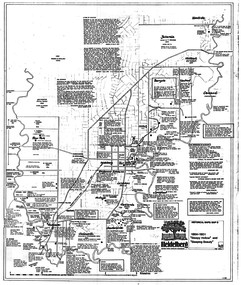
Map, Heidelberg. Historic River Landscape Assessment. Historical maps: Map C 1851-1863. "The Garden of the colony", 1985c
Geographical area of around 35 sq. kilometres marked with physical features such as major roads, vegetation and properties, with locations and notes of the increasing number of farms, gardens orchards and vineyards which had become established in addition to pastoral runs. Bounded by Shire of Diamond Valley to the North, Darebin Creek to the West and Plenty River to the East.Black and white sketch map on white paperheidelberg, heidelberg - maps -
 Greensborough Historical Society
Map, Heidelberg: Historic River Landscape Assessment. Historical maps. Map D 1864 -1901 "Sleepy Hollow" and "Sleeping beauty", 1985c
Geographical area of c. 35 sq. kilometres marked with physical features such as major roads, rivers, vegetation and properties, with locations and notes on the increasing number of farms, orchards and vineyards that had been developed in addition to pastoral runs. Bounded by Shire of Diamond Valley to the North, Darebin Creek to the West, and Plenty River to the East.Black and white sketch on white paper. Second copy 600 x 430 cm printed in black on semi-opaque paperheidelberg, heidelberg - maps -
 Greensborough Historical Society
Map, Heidelberg: Historic River Landscape Assessment. Historical maps. Map E 1901-1934 "A Time of projects and improvements", 1985c
Geographical area of around 35 sq. kilometres marked with physical features such as major roads, railways (new extension to Eltham), rivers and properties, also housing sub-divisions and community facilities such as hospitals, parks and sporting reserves and indications of new small scale industries such as dairying. Bounded by Shire of Diamond Valley to the North, Darebin Creek to the West and Plenty River to the East. Black and white sketch map on white paperheidelberg, heidelberg - maps -
 Greensborough Historical Society
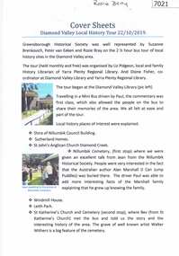
Booklet and article, Diamond Valley Local History Tour 2019, by Yarra Plenty Regional Library, 22/10/2019
Cover article written by Rosie Bray. In addition to YPRL booklets which have a brief history of each site visited, there are leaflets on Anglican parish of Diamond Creek; Nillumbik Cemetery; Ellis Cottage; Greensborough Cemetery and Sutherland Homes for ChildrenBooklet (2 copies) containing a brief history of sites visited on the Library's Diamond Valley Tour 2019, with 21 p. of supplementary information by various writers and 6 photographs taken on the tour.diamond valley, yarra plenty regional library, sutherland homes, st katherines church st helena, andrew yandell reserve, greensborough rsl, greensborough war memorial park, greensborough cemetery -
 Greensborough Historical Society
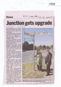
Newspaper Clipping, Junction gets upgrade, 19/12/2007
Article on the upgrade of the Diamond Creek Road and Plenty River Drive intersection. Black and white text, colour imageplenty river drive greensborough, diamond creek road greensborough -
 Greensborough Historical Society
Map, Melbourne and Metropolitan Board of Works. Survey Division, MMBW, Yarra 2500 / 15.23. Diamond Creek Reserve, 1978_02
... and metropolitan board of works shire of diamond valley diamond creek ...Melbourne and Metropolitan Board of Works. Yarra 2500 [base map] 15.23. Hurstbridge. Municipality of Diamond Valley 257. Prominent streets include: Challenger Street, James Cook Drive and Ryans Road / Main Street. Features include the Diamond Creek and Diamond Creek Reserve.MMBW Map in 1:2500 [scale] series. Cream parchment with green tape reinforcing on edges and punched holes on left edge.mmbw, melbourne and metropolitan board of works, shire of diamond valley, diamond creek - maps -
 Greensborough Historical Society
Map, Melbourne and Metropolitan Board of Works. Survey Division, MMBW, Yarra 2500 / 15.22. Eltham North. Allendale Road, 1979_08
Melbourne and Metropolitan Board of Works. Yarra 2500 [base map] 15.22. Eltham North, Allendale Road. Parish of Nillumbik. Municipalities of Eltham 238 and Diamond Valley 257. Prominent streets include: Allendale Road, Godber Road and Ryans Road. Features include the Diamond Creek.MMBW Map in 1:2500 [scale] series. Cream parchment with green tape reinforcing on edges and punched holes on left edge.mmbw, melbourne and metropolitan board of works, shire of diamond valley, nillumbik, eltham - maps -
 Greensborough Historical Society
Map, Melbourne and Metropolitan Board of Works. Survey Division, MMBW, Yarra 2500 / 15.21. Eltham North, 1979_08
Melbourne and Metropolitan Board of Works. Yarra 2500 [base map] 15.21. Eltham North. Parish of Nillumbik 3310. Municipalities of Diamond Valley 257 and Eltham 238. Prominent streets include: Progress Road, Glen Park Road and Zig Zag Road. Features include the Diamond Creek, Eltham Council Pound and Eltham North Reserve.MMBW Map in 1:2500 [scale] series. Cream parchment with green tape reinforcing on edges and punched holes on left edge.mmbw, melbourne and metropolitan board of works, shire of diamond valley, nillumbik, eltham - maps -
 Greensborough Historical Society
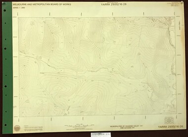
Map, Melbourne and Metropolitan Board of Works. Survey Division, MMBW, Yarra 2500 / 16.26. Diamond Creek, Broadgully Road, 1978_07
... and metropolitan board of works shire of diamond valley diamond creek ...Melbourne and Metropolitan Board of Works. Yarra 2500 [base map] 16.26. Diamond Creek, Broad Gully Road. Municipalities of Diamond Valley 257 and Eltham 238. Prominent streets include: Wadeson Road, Broad Gully Road and Glenhaven Road. Features include the Diamond Creek.MMBW Map in 1:2500 [scale] series. Cream parchment with green tape reinforcing on edges and punched holes on left edge.mmbw, melbourne and metropolitan board of works, shire of diamond valley, diamond creek - maps