Showing 5916 items
matching east road
-
 Ringwood and District Historical Society
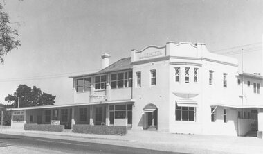
Photograph, Club Hotel, Mount Dandenong Road, East Ringwood in February 1960
... Club Hotel, Mount Dandenong Road, East Ringwood in February... in the early 2020s. Club Hotel, Mount Dandenong Road, East Ringwood ...Black and white photographs of Club Hotel February 1960 (1 original, three copies). The hotel has a long association with the Reddish family, thus given the name of "Daisy's Hotel". Included 2 copies of the photograph. Ryman Healthcare bought the site in 2019, including the garden supply business next door, making up a 2.2ha area. The proposal was for a $220 million retirement village to be built. The location is next to Ringwood Lake with the old hotel being knocked down in the early 2020s. -
 Eltham District Historical Society Inc
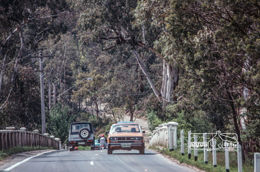
Photograph, Fred Mitchell, Looking east across Main Road Bridge over the Diamond Creek, Eltham South, 1983, 1983
... Looking east across Main Road Bridge over the Diamond Creek... melbourne fred mitchell collection 1983 main road bridge eltham ...Digital copy of colour photographfred mitchell collection, 1983, main road bridge, eltham south -
 Eltham District Historical Society Inc
Photograph, Fred Mitchell, Looking east across Main Road Bridge over the Diamond Creek, Eltham South, 1983, 1983
... Looking east across Main Road Bridge over the Diamond Creek... melbourne fred mitchell collection 1983 main road bridge eltham ...Digital copy of colour photographfred mitchell collection, 1983, main road bridge, eltham south -
 Ringwood and District Historical Society
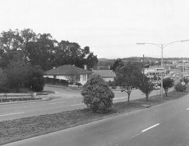
Photograph, Maroondah Highway West, Ringwood- 1969. Looking east from Heatherdale Road
... Maroondah Highway West, Ringwood- 1969. Looking east from..., Ringwood- 1969. Looking east from Heatherdale Road. Photograph ...Black and white photographWritten on back of photograph: "May 1969. Eastern view from corner of Maroondah Highway and Heatherdale Road." -
 Ringwood and District Historical Society
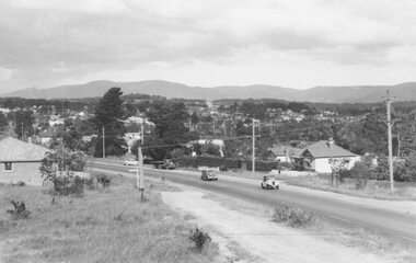
Photograph, Maroondah Highway West, Ringwood- c1940's. Looking east from Heatherdale Road
... Maroondah Highway West, Ringwood- c1940's. Looking east... Road Ringwood North melbourne Written on back of photograph ...Black and white photographWritten on back of photograph: "See booklet- 'Welcome to Ringwood' 1948/1949".(Which shows identical image on front cover). -
 Ringwood and District Historical Society
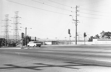
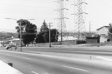
Photograph, Maroondah Highway West, Ringwood- 1969. Looking east from Heatherdale Road
... Maroondah Highway West, Ringwood- 1969. Looking east from...- 1969. Looking east from Heatherdale Road. Photograph ...Black and white photographWritten on back of photograph: "May 1969" Image shows pylons for high voltage power lines. -
 Ringwood and District Historical Society
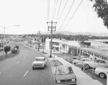
Photograph, Maroondah Highway West, Ringwood- 1969. Looking east from Heatherdale Road
... Maroondah Highway West, Ringwood- 1969. Looking east from..., Ringwood- 1969. Looking east from Heatherdale Road. Photograph ...Black and white photographImage taken from front of 'Bill Wing Motors'. -
 Ringwood and District Historical Society
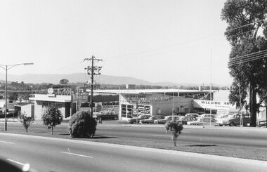
Photograph, Maroondah Highway West, Ringwood- 1969. Looking east from Heatherdale Road
... Maroondah Highway West, Ringwood- 1969. Looking east from... Road Ringwood North melbourne Written on back of photograph ...Written on back of photograph: "May 1969" -
 Ringwood and District Historical Society
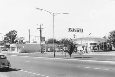
Photograph, Maroondah Highway West, Ringwood- 1969. Looking east near Wantirna Road
... Maroondah Highway West, Ringwood- 1969. Looking east near..., Ringwood- 1969. Looking east near Wantirna Road. Photograph ...Black and white photographWritten on back of photograph: "May 1969". Image shows 'Seaboard Finance', and 'Shell Service Station'. -
 Whitehorse Historical Society Inc.
Photograph, Springvale Road East Burwood
... Springvale Road East Burwood... of Springvale Road & Burwood Hwy East Burwood. First stages of the Tally... of Springvale Road & Burwood Hwy East Burwood. First stages of the Tally ...The Tally Ho Business Park was built on vacant land previously owned by the Methodist Church. The land was sold cheaply to the Church by Abel Hoadley, and the Tally Ho Boys Home was erected there. A change in the care of the boys meant that the land became vacant for a considerable time before buildings appeared. The Country Fire Authority, Vic Roads and World Vision are also located there.4 coloured photographs (a-d) taken at the intersection of Springvale Road & Burwood Hwy East Burwood. First stages of the Tally Ho Business Park in the background.tally ho business park, businesses -
 Melbourne Legacy
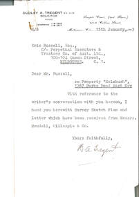
Document, re Property "Holmbush", 1267 Burke Road East Kew, 1943
... re Property "Holmbush", 1267 Burke Road East Kew... Property "Holmbush", 1267 Burke Road East Kew Document ...Formal identification of the property to be bought as the first Melbourne Legacy residence sent to Legatee E. Russell, Chair of the Hostel Committee. The survey is hand drawn and meticulously measured.The documents demonstrate business practices in the 1940s with regard to the purchase of property, as well as being an important record of the first property to be purchased by Melbourne Legacy as a residence for children.00310.1 Letter from Dudley A. Tregent, Solicitor, dated 15 January 1943, to Legatee E. Russell, Chair of the Hostel Committee, enclosing the survey sketch plan. White paper, black letterhead and typing, two holes punched for filing 00310.2 Survey sketch plan by Meudell, Gillespie & Co, dated 13 January 1943. Black type and printing, with some red shading and writing, on white foolscap paper. 00310.3 Letter from Meudell, Gillespie & Co to Mr. D.A. Tregent, Solicitor. Quarto, black typing, red underlining, on white.00310.1 Signed by D.A. Tregent 00310.2 Signed by Percival A. Jordan 00310.3 Signed by Percival A. Jordanholmbush initial negotiations, properties, holmbush -
 Melbourne Legacy
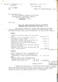
Letter - Document, letter, re D. N. Craig and Others from W.G. Thomson / Property 1267 Burke Road, East Kew, 1943
... Burke Road, East Kew... / Property 1267 Burke Road, East Kew Letter Document, letter ...Letter from Dudley A Tregent, Solicitor showing an outline of the final payment required for purchase of the Holmbush property, including stamp duty, transfer of Title fees and Council Rates. A record of the costs of acquiring property as well as being an important record of the first property to be purchased by Melbourne Legacy as a residence for children.Quarto copy paper, black and white, two hole punched for filing.holmbush initial negotiations, holmbush, properties -
 Melbourne Legacy
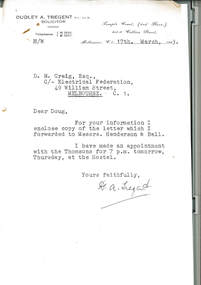
Letter - Document, letter, re Property 1267 Burke Road, East Kew, 1943
... re Property 1267 Burke Road, East Kew... for filing. re Property 1267 Burke Road, East Kew Letter Document ...00331.1 A copy of the letter from the solicitor to the real estate agents that handled the transaction to claim for the return of items included in the purchase of the Holmbush property that were removed by the previous owner. 00331.2 A note to accompany the copy of the letter.Business practices in the 1940s around the purchase of the first property by Melbourne Legacy as a residence for children.00331.1 Quarto white copy paper, black type, two hole punched for filing. 00331.2 White note paper, black type, two hole punched for filing.holmbush initial negotiations, holmbush -
 Surrey Hills Historical Society Collection
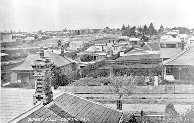
Photograph, Surrey Hills - Looking East from Essex Road, circa 1900, c1900
... Surrey Hills - Looking East from Essex Road, circa 1900... Hills - Looking East from Essex Road, circa 1900 Photograph ...Date is approximate. Two original post cards of this image - "Surrey Hills - looking East" - were donated by Stephen Wyatt on 10 March 2012. One is blank; the other has been sent to Mrs A Wyatt, C/O Mrs E Young, 'Grand View', Warburton from daughter Nellie from 'The Quantocks', Surrey Hills - postmarked 10 Dec 1906. There is also a reproduction of this image in a framed collage of Surrey Hills photos.This is the earliest known image of the Surrey Gardens. The layout was originally designed by William Guilfoyle, who also designed Melbourne’s Royal Botanic Gardens.Black and white photo taken from an early postcard. Taken from the roof of a house in Essex Road, it shows the development of housing between Essex and Union Roads and includes the section of land fenced off for the Surrey Gardens with paths roughly laid out, one existing tree but no tree planting. The houses depicted are largely Edwardian timber buildings with corrugated rooves. There are still some vacant blocks. Kirkland on Union Road can be seen in the distance, as can some of the shops along Canterbury Road.Lower LHS within original image: " Surrey Hills - Looking East"; on the rear "No 17" in black pen in top LH corner.edwardian style, residential development, kirkland, essex road, suffolk road, norfolk road, surrey gardens, post card -
 Surrey Hills Historical Society Collection
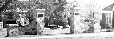
Photograph, View of Surrey Gardens looking east from Union Road
... View of Surrey Gardens looking east from Union Road... can be seen. View of Surrey Gardens looking east from Union ...The 2 cannons in the gardens were acquired by Mr Arthur Brookes, popularly known as 'Empire Brookes'. They were from a British vessel used during the Crimean War and were originally placed in the grounds of the Guildford Road Recreation Oval. The Dimmick Gateway was erected in 1950 by the citizens of Camberwell in memory of Cr William Dimmick, JP, Mayor of Camberwell, 1935-1936 and a Councillor from 1934-1947. There is a photo of him in Mayoral robes in the City of Boroondara Library Service collection. Cr Dimmick was commonly called Roy.Black and white photo of the Dimmick Gateway in Surrey Gardens. The gateway is built as if it was designed to have a fence attached but there is none. There are 2 tall central pillars and an arched bridge to 2 smaller pillars. It appears to be constructed from a variegated slate material. There is a light on the top of each of the tall pillars and also a plaque. To the RHS of the photo is part of the Surrey Shrine, skirted by 2 cypress trees. A canon and the Memorial Cross can be seen between the gateway pillars and to the LHS of the photo the wooden bandstand can be seen.dimmick gateway, surrey gardens, surrey shrine, boer war, bandstand, parks and reserves, cr william dimmick, roy dimmick -
 Surrey Hills Historical Society Collection
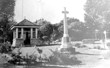
Photograph, City of Camberwell Council, Surrey Gardens, looking east from Union Road, 1933
... Surrey Gardens, looking east from Union Road... Gardens, looking east from Union Road Photograph City ...The Honor Roll and Shrine in the Surrey Gardens were opened on Sunday 7 April 1918, prior to the cessation of fighting. Mrs Charles H D Steele (MS: Sarah Margaret Russell), president of the local Patriotic League, is credited with the idea of building The Shrine as a fitting memorial to the soldiers of the district. The Surrey Hills Progress Association coordinated raising funds from local residents. John Kendrick Blogg carved the beautiful honor roll in Indian teak and Australian white mahogany and the design of The Shrine was by architectural firm Gawler & Drummond. John Stevens Gawler was a partner in the firm, lived locally and also enlisted. Although he may have been overseas during some of the design process he is often credited with the design. Both men donated their services. The 2 cannons in the gardens were acquired by Mr Arthur Brookes in 1901 to commemorate the end of the Boer War. He was popularly known as 'Empire Brooks' and the cannons as 'Brooks' Babies'. They were originally placed in the grounds of the Guildford Road Recreation Oval. Arthur Brooks was an active community member and one of the founding members of the Surrey Hills Progress Association. Original photo was contained in a booklet printed by Camberwell Council in 1933.This is one of the earliest known photos of 3 elements important in designating the Surrey Gardens as one of the City of Boroondara's heritage gardens, now protected by a heritage overlay. The Shrine was one of the first WW1 memorials to be built in Australia and possibly the first in Victoria. It was unveiled prior to the end of hostilities and was built entirely through local community effort. The design of The Shrine, reflective of domestic architecture, is unusual. Its Honor Roll is also a noted example of sculptor John Kendrick Blogg's work and valued especially for its incorporation of Australian motifs, wattle blossom and gum leaves. The boomerang over the full width of the monument was said to be symbolic of both those who did and did not return. Black and white photo of part of the Surrey Gardens, located between Union Road and Norfolk Road, Surrey Hills. It shows The Shrine, the cannons installed to commemorate the end of the Boer War and the Memorial Cross. Taken from within the park looking east. surrey gardens, shrine of remembrance, monuments and memorials, boer war, mr john kendrick blogg, mr arthur brooks, mrs charles steele, mrs sarah steele, miss sarah margaret russell, cannons, mr john gawler -
 Melbourne Tram Museum
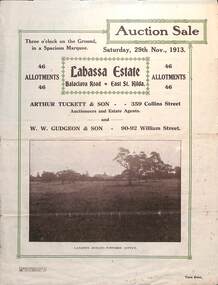
Ephemera - Real estate sale, Arthur Tucett & Son, "Labassa Estate" - Balaclava Road, East St Kilda, Nov. 1913
... "Labassa Estate" - Balaclava Road, East St Kilda.... "Labassa Estate" - Balaclava Road, East St Kilda Ephemera Real ...Pamphlet advertising the sale of land at the Labassa Estate, Balaclava Road 29-11-1913. Promotes the tram service, St Kilda Esplanade with a photo of PMTT 15 at the entry to Labassa at the corner of Orrong Road and Balaclava Road. Has a plan for the sub-division in to 46 allotments, terms of sale, and restrictions of what could be built on the land. The original Labassia Mansion is now owned by the National Trust.Demonstrates the style of land sale pamphlet including the availability of tram services to prospective purchasers.Pamphlet - folded - printed in two colours of cream coloured paper with photographs and plans.sale of land, trams, balaclava, balaclava road, real estate, labassa, orrong road -
 Ringwood and District Historical Society
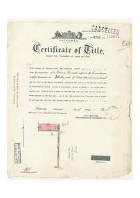
Document, Certificate of Title - Leslie Mills of Plymouth Road, East Ringwood, Farmer - part of Crown Section 20, Parish of Warrandyte, County of Evelyn - 19th January, 1932
... Certificate of Title - Leslie Mills of Plymouth Road, East... Road, East Ringwood, Farmer - part of Crown Section 20, Parish ...A4 copies of Landata Victoria Historical Search documents - Vol 5781 Fol 1156174.Leslie Mills is now the proprietor of an Estate in Fee-simple subject to the Encumbrances notified hereunder ... 10 acres or thereabouts, together with a right of carriage way over Grandview Grove (later Bemboka Road), Warranwood, Victroia. Transfers include Alexander William Brown of Tooradin, Farmer - 29th October, 1945, (died 25th June, 1957), Probate granted 28th January, 1958, to Alfred Hart Brown of Dandenong, Estate Agent, and Harry Britten Elms of Cardinia, Gentleman (*** See Probate details below) Oliver Burgess, Grandview Grove Ringwood, Florist - 14th May, 1964, Privatus Proprietary Limited, St.Kilda Road, Melbourne - 27th October, 1977, John Patrick Kelly, Company Director and Yvonne Gloria Kelly, Married Woman, joint proprietors, 10th September, 1980 *** Inventory of Real Estate Assets (for Probate purposes 4/10/1957) detailed in Family Genealogy record for A.W. Brown includes: "Grandview Grove, Ringwood Land containing 10 acres or thereabouts situate in Grandview Grove Ringwood being part of Crown Section 20 Parish of Warrandyte County of Evelyn and being the land described in Certificate of Title Volume 5781 Folio 174 on which is erected a 7 room house, a bungalow, shed and 2 glass houses valued by E. Miles, Ringwood - £5077-0-0 -
 Ringwood and District Historical Society
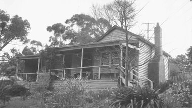
Photograph, "Johnswood" - Home of Charles Wedge, Eastfield Road, East Ringwood - 1964 (demolished in 1967)
... "Johnswood" - Home of Charles Wedge, Eastfield Road, East... of Charles Wedge, Eastfield Road, East Ringwood - 1964 (demolished ...Black and white photograph of weatherboard house. (2 copies- 1 large, 1 small)Written on backing sheet of large copy: " 'Johnswood', Home of Charles Wedge, President of old Ringwood East Progress Association. Related to John Helder Wedge, Batman's surveyor.1964." Written on back of small copy: "Home of CHarles Edward Lyndhurst Wedge. Died 1962." Demolished 1967 -
 Ringwood and District Historical Society
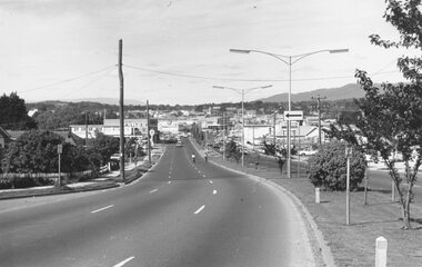
Photograph, Maroondah Highway West, Ringwood- c1973. Looking East from Heatherdale Road
... Maroondah Highway West, Ringwood- c1973. Looking East from... West, Ringwood- c1973. Looking East from Heatherdale Road ...Black and white photograph (2 copies) -
 Ringwood and District Historical Society
Photograph, Maroondah Highway West, Ringwood- 1969. Looking east from Heatherdale Road
... Maroondah Highway West, Ringwood- 1969. Looking east from...- 1969. Looking east from Heatherdale Road. Photograph ...Black and white photograph -
 Ringwood and District Historical Society
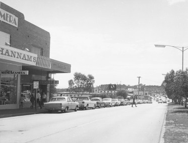
Photograph, Maroondah Highway Central, Ringwood. Looking east towards Warrandyte Road, 1974
... Maroondah Highway Central, Ringwood. Looking east towards..., Ringwood. Looking east towards Warrandyte Road, 1974. Photograph ...Black and white photograph Image shows Hannams Camera store, and Safeway roof near Warrandyte Road. -
 Ballarat Tramway Museum
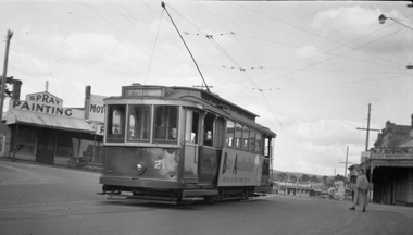
Negative, Wal Jack, No. 21 outbound in Main Road Ballarat East, 15-9-1953
... No. 21 outbound in Main Road Ballarat East... Negative file of No. 21 outbound in Main Road Ballarat East... Road Ballarat East at the intersection with Humffray St. Tram ...Print notes the "Made in Australia" side posters on the side of tram 21. Taken opposite Ballarat East Post Office, Main St 15-9-1953.Yields information about celebrations the intersection of Main Road and Humffray St and Ballarat 21.Negative and Digital image of the Wal Jack Ballarat Negative file of No. 21 outbound in Main Road Ballarat East at the intersection with Humffray St. Tram has a large "Buy Australia" panel on the side and destination of Mt Pleasant. - See Reg Item 5333 for another photo of the tram. in the background is a motor body workshop and Robson's Glass shop. Print also held - see item 8992trams, tramways, humffray st, main road, mt pleasant, decorated trams, buy australian, tram 21 -
 Whitehorse Historical Society Inc.
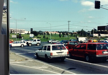
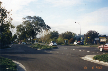
Photograph, Whitehorse Road, Mitcham
... Coloured photo of Whitehorse Road looking east from... of Whitehorse Road looking east from the corner of Doncaster East Road ...Coloured photo of Whitehorse Road looking east from the corner of Doncaster East Road. Taken 2003whitehorse road, mitcham -
 Whitehorse Historical Society Inc.
Legal record - Land Title, Springvale Road, 1960
... Highway, south past Highbury Road and east to Vermont South.... Mitcham melbourne Aerial photographs Springvale Road Burwood East ...Aerial photograph of cnr. Springvale Road and Burwood Highway, south past Highbury Road and east to Vermont South.Aerial photograph of cnr. Springvale Road and Burwood Highway, south past Highbury Road and east to Vermont South.Aerial photograph of cnr. Springvale Road and Burwood Highway, south past Highbury Road and east to Vermont South.aerial photographs, springvale road, burwood east, burwood highway, burwood east, highbury road, burwood east, vermont south -
 Ringwood and District Historical Society
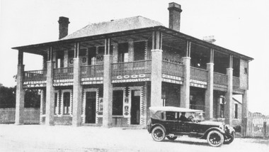
Photograph, Club Hotel, Mount Dandenong Road, Ringwood East in 1924, 1924
... Club Hotel, Mount Dandenong Road, Ringwood East in 1924... Dandenong Road, East Ringwood. The image was copied from... on Mount Dandenong Road, East Ringwood. The image was copied from ...Black and white photograph of the Club Hotel on Mount Dandenong Road, East Ringwood. The image was copied from the "Ringwood East Electric Station Estate" land sales brochure dated 1st November 1924. Refer to #5132. The hotel has a long association with the Reddish family, thus given the name of "Daisy's Hotel". Included 2 copies of the photograph. Ryman Healthcare bought the site in 2019, including the garden supply business next door, making up a 2.2ha area. The proposal was for a $220 million retirement village to be built. The location is next to Ringwood Lake with the old hotel being knocked down in the early 2020s.Was item H7 in the previous numbering system. -
 Glen Eira Historical Society
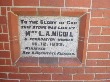
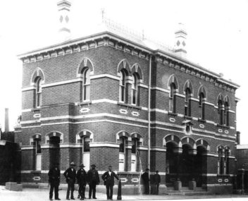
Article - St. Andrew’s Presbyterian Church, North Road, Gardenvale East
... St. Andrew’s Presbyterian Church, North Road, Gardenvale... Presbyterian Church, North Road, Gardenvale East ...Handwritten document giving brief details on wording on foundation stone of St. Andrew’s church, undated and author unknown. Photocopy of pamphlet produced for the stewardship campaign 1957 for St. Andrew’s Presbyterian Church Gardenvale East, with several photos. It includes history as well as current situation at 1957. Photocopied notes and photo of the Army Hut used by Gardenvale Primary School in 1921 only as donated by church for and year then Reverted back to church use. Photocopy of letter to Glen Eira News and City Council re-proposed subdivision of church land from Robert W. Sinclair.st. andrew’s presbyterian church, foundation stones, nicoll l.a., heathcote-fletcher a. rev., north road, seach street, smith a. f.h. rev., mcneilage alex rev., gardenvale east, caulfield south, younger street, gardenvale east church, nicholls rev., rowlands w. rev., lang walter, sunday schools, yeaman f.e. rev., brown f.e., brick, towers, manse, choirs, groups, smith mrs., curtis e.e., morse roger, marryatt harry, pegler adrian, savill t., south caulfield, gardenvale primary school, sinclair robert w., dakin ms., campbell felicity -
 Ballaarat Mechanics' Institute (BMI Ballarat)
Ballarat East Post Office Main Road
... Ballarat East Post Office Main Road... Office Main Road Ballarat East Post Office Main Road ...This photograph is from the Max Harris Collection held by the Ballaraat Mechanics' Institute. Please contact BMI for all print and usage inquiries.ballarat, east, post office, main road -
Canterbury History Group
Photograph - Shop No. 94 maling Road on the east corner of Maling Road and Bryson Street, Jan Pigot, 27/03/1993 12:00:00 AM
... Shop No. 94 maling Road on the east corner of Maling Road... and Bryson Street. Photograph Shop No. 94 maling Road on the east ...Coloured photograph of pharmacy shop No. 94 on the corner of Maling Road and Bryson Street.canterbury, maling road, shops, paving, trees, signs -
Canterbury History Group
Photograph - Canterbury Road and Balwyn Road looking east
... Canterbury Road and Balwyn Road looking east...Circa 1900 Canterbury Road Canterbury Gardens Canterbury ...Circa 1900Black and white photographcanterbury road, canterbury gardens, canterbury mansions, horse and carriages, street trees, vintage clothing