Showing 316 items
matching eastern hill
-
 Eltham District Historical Society Inc
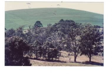
Photograph, Sherbourne Road, Para Road and Simms Road at Briar Hill, 3 November 1967, 3 Nov 1967
Viewed from eastern side of Para Road opposite Graham Body Works.. Simms Road is running to the right in front of the old house. The house belongs to Mrs Cameron whose daughter married a DAVEY after which Davey Street is named. Excavation work is being undertaken for the realignment of the Para Road and Sherbourne Road intersection where the current roundabout is located, approximately where the two cars are parked. Mrs Cameron's house and the other are where Montmorency Secondary College is situated. The school opened in 1969.Roll of 35mm black and white negative film, 6 strips Ilford HP3briar hill, cameron, davey, davey road, graham body works, greensborough, montmorency secondary college, sherbourne road, simms road -
 Eltham District Historical Society Inc
Photograph, Sherbourne Road, Para Road and Simms Road at Briar Hill, 3 November 1967, 3 Nov 1967
Viewed from eastern side of Para Road opposite Graham Body Works.. Simms Road is running to the right in front of the old house. The house belongs to Mrs Cameron whose daughter married a DAVEY after which Davey Street is named. Excavation work is being undertaken for the realignment of the Para Road and Sherbourne Road intersection where the current roundabout is located, approximately where the two cars are parked. Mrs Cameron's house and the other are where Montmorency Secondary College is situated. The school opened in 1969.Roll of 35mm black and white negative film, 6 strips Ilford HP3briar hill, cameron, davey, davey road, graham body works, greensborough, montmorency secondary college, sherbourne road, simms road -
 Federation University Historical Collection
Document - Documents, Golden Point - Mount Pleasant Progress Association Establishment
The Golden Point - Mt Pleasant Progress Association was established on Wednesday 6 April 1983. Membership was open to any person or organisation in the area generally bounded by Bridge mall and Skipton Street, Elsworth Street and main Road. annual family or organisation membership was $2.00. Mara Gluyas served as secretary of the Golden Point - Mt Pleasant Progress Association from 1983 to 1994. Ian McKinnon was the President from 1983 to 1992. Kerry Daniels was the President in 1994.A small white cardboard box with purple lid of A4 documents relating to the establishment of the Golden Point - Mt Pleasant Progress Association. The documents include the original constitution and minutes. Topics include: Pearce's Park; removal of elms, names and addresses of members, Sovereign Hill realignment; Sovereign Hill Lookout; membership form; Golden Point Historic Mines Direction Indicator; Ballarat Observatory; Nerrina Tip; Yarrowee Creek; Mine Capping (Sovereign Mine); tree planting (Sovereign Hill Lookout); Magpie Street Park; Hill Street; Yarrowee Flora Park; Barkly Street; South Street Bluestone Gutter; Ballarat Goldfields; Eastern baths site; Grant Street; Flooding; Aboriginal Advancement League; Sunnyside Woollen Mill; Chinese Garden; Golden Point Primary School closure; Ballarat West Goldfields; Sovereign Hill Land Title and Management Revision; Wainwright; Street; Llanberris; Yuille's Station Parkgolden point, mount pleasant, mt pleasant, ian mckinnno, mara gluyas, peter hiscock, frank williams, geoff howard, leigh gillett, sovereign hill, kerry daniels, norm strange; graeme kent; george netherway; keith rash; ian mckinnon, albert graham, bryan crebbin, jim humphreys. wid radbourn, heath martin, janet dore, alex mills park -
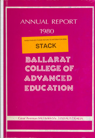 Federation University Historical Collection
Book, Ballarat College of Advanced Education Annual Report, 1980
In 1980 M.B.John was Council President. In 1980 the School of Arts moved into their new building, 1870 Founders Hall was financed - at a cost of $800,000 - from the proceeds of the SMB Centenary Appeal, and was completed late in 1980. Extensive work was carried out on the Student Residences and the former Education Department Hostel in Victorian Street. The amphitheatre adjacent to the eastern side of the Education Buildings was constructed, together with the nearby disabled ramp. Negotiations with the Shire of Buninyong were continued for access to the campus from the Green Hill Road. Following the creation by Act of Parliament in 1978 of the Victorian Post-Secondary Education Commission (VPSEC) amendments to the same Act early in 1980 made provision for the repeal of the VIC and SCV Acts. From mid-December 1980 these latter two bodies ceased to exist when the provisions for repeal of their Acts were proclaimed. The Victorian Institute of Colleges had been set up in 1965 to aid in the co-ordination and development of a number of non-university tertiary institutions that affiliated with it from 1965 on to become Colleges of Advanced Education. In taking up this role which had been spelt out in 1964 by the martin Committee, the VIC broke new ground in a whole range of operations. It became responsible for the physical development of new building programmes and new campuses from many of its colleges, for the procurement of operating funds from the Commonwealth, for the accreditation of new courses of study, for the first non-university degrees to be awarded in Australia and so on. The Former Ballarat Institute of Advanced Education (the tertiary division of the School of Mines) was affiliated with the VIC from the outset and its progress towards a new status, rapid growth and vastly improved physical resources was closely linked to and dependent upon the efforts of the VIC. The similar co-ordinating authority - The State College of Victoria - was established in 1973 to similarly foster the autonomous development of the former teachers colleges. its early work was highly influential in the transition of the Ballarat Teachers' College into the State College of Victoria at Ballarat. On the merging of the BIAE and the SCVB in 1976, the new college continued under the co-ordination of the Victorian Institute of Colleges. The major contribution made to the progress and stature of became the Ballarat College of advanced Education by both the VIC and SCV, and their Councils and officers, over the formative years of rapid change and evolution is acknowledged and recorded with appreciation. Such efforts by the two central authorities have markedly assisted in bringing the College to the present point where its accumulated experiences and traditions provide a sound basis on which it can confidently and responsibly exercise the greater autonomy gradually passing it. Purple soft covered book of 47 pages. Contents include: development of a Nurse education course, College organisational Structure, Role of Head of School, resignation of Norman Baggaley, appointment of R. Macgowan, opening of Business Resource Centre, Librarianship, resignation of M.J. Sandow-Quirk, E.A. Widdop, J. Leeuwenburg, Thelma Rungkat, Erica Myers, former Acting Head of School John Mildren elected to the Federal seat of Ballarat, Ray Watson, Resignation of A.C. Burrow, return of W.J. Vermeend, P.L. McCarthy, P.R. Calder, J.A. Fulcher, L.E. Taylor, L.J. McGrath, Teaching Resource Centreballarat college of advanced education, bcae, mt helen, mount helen, sandow-quirk, widdop, leeuwenburg, rungkat, myers, burrow, vermeend, mccarthy, calder, fulcher, taylor, victoria street -
 Federation University Historical Collection
Book, Report on the Ballarat East Gold-Field, 1894 and Ballarat East Gold-Field, 1907, 1894
The Ballarat Ironworkers' and Polytechnic Association was at the Ballarat School of Mines. In 1907 J.W. Gregory Professor of Geology at Glasgow Univesity, Late Director of the geological Survey of Victoria and Professor of Geology at Melbourne University. W. Dickson was Secretary for Mines and Donald McLeod was the Minister of Mines. in 1894 Ernest Lidgey was the Assistant Geological Surveyor for the Victorian Department of Mines. A.W. Howitt was Secretary for Mines and Henry Foster was the Minister of Mines. Charcoal hard covered report on the Ballarat East Goldfield. The book combines two reports from the Victorian Department of Mines. The 1894 report is 52 pages and includes images and plans. The 1907 Report is number 4 in the Memoirs of the Geological Survey of Victoria. Photographs include Looking South from the Britannia Mullock Heap, View from Sovereign Hill, Golden Point gold discovery site.Stamped "Ballarat Ironworkers' Association School of Mines" Bookplate of the Ballarat Ironworkers' and Polytechnic Association. Written inside front cover: "S.J. Miller, 115 Ascot Street, Ballarat"ballarat ironworkers' and polytechnic association, ballarat school of mines, ironworkers, geology, mining, ballarat east, llanberris, victoria united mine, normanby, north woah hawp, bookplate, s.j. miller, library plate, golden point, gold discovery at golden point, new normanby mine, william baragwanath, new speedwell, britannia united, llanberris co, sulieman pasha, prince regent, dalzell-cum-prince regent, north prince extended, eastern star, f. gray, victoria united gold mine, sovereign hill mine, prince regent mine, britannia mine -
 Federation University Historical Collection
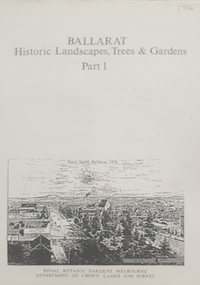
Book, Peter Lumley et al, Ballarat: Historic Landscapes, Trees & Gardens, 1983, 1983
Lisa Green and Lisa Morcom of Ballarat College of Advanced Educatiion contributed to this report.275 page landscape study of Ballarat including Trees in the Victorian Landscape; Plant sources early Ballarat nurseries, Botanical Gardens, Lake Wendouree, Fairy Gardens, Victoria Park, Ballaarat Old Cemetery, Eastern Oval, City Oval, Ballarat East Town Hall Gardens, Eureka Stockade, Observatory, Yarrowee, Black Hill, Sovereign Hill, Cheek Channels, Canadian Creek, Poverty Point Reserve, Goldmining Relics, Woah Hawp, Buninyong, street plantings, Russell, Victoria, Bridge Mall, Sturt Street Gardens, Avenue of Honour, Webster, Elms, ballarat, trees, nursery, r.u. nicholls, francis moss, ballarat botanical gardens, victoria park, lake wendouree, ballaarat old cemetery, eastern oval, ballarat east town hall gardens, ballarat school of mines botanical gardens, eureka stckade recreation reserve, ballarat observatory, yarrowee creek, black hill reserve, sovereign hill, ballarat avenue of honour, victoria street plantings, bridge mall plantings, george longley -
 Federation University Historical Collection
Booklet, Thomas Stephen Hart, The Highlands and Main Divide of Western Victoria, 1907, 12/12/1907
Thomas S. Hart was a teacher at the Ballarat School of Mines, and a member of the Ballarat Field Naturalists ClubArticle with illustrations published by the Royal Society of Victoria by Thomas S. Hart. The following plates are included: Fig 1. The Main Divide and some of the transverse ridges Fig 2. Hills on and near the Divide at the Ercildoun and Ascot Gaps Fig. 3. Profile of the Divide at Ascot Gap. Fig. 4. Sketch of the Hills west and north-west from Mt Buninyong - - The divide in Ascot Gap from Mt Blowhard (Serra Range, Mt William, Mt Ararat, Larne Gerin, Ben Major, Mt Cole, Mt Misery, Mt Bolton) Fig. 5. Diagram to illustrate the possible courses of the leads south of the present Divide - Burrumbeet Basin (Smythesdale, Ballarat, Lal Lal , Mt Doran, egerton, Parwan Creet, Rowsley Fault, Eastern Plateau) Fig. 6. Diagramatic cross section of the grampians, south of Hall's Gap. Profile of the Pyranees, from maiden Hill - Diagramatic Section of the Grampians south of Hall's Gap. (Mt Cole, Mt Mitchell, Ben Major, Ben More, Avoca Hill, Hall's Gap.) Fig. 7. Profile of the Pyrenees as seen from Maiden Hill near Waubra.thomas hart, thomas s. hart, ballarat school of mines, ballarat field naturalists club, royal society of victoria, western victoria, ballarat, great dividing range, mt william, volcano, volcanic plains, waterways, lal lal basin, yarrowee creek, ballarat common, lava flow, wendouree, warrenheip, ballarat plateau, mt elephant, grampians, t.s. hart, mt buangor, mt beckworth, mt misery, mt bolton, lal lal iron ored, mt ararat, mt wiliam, mt cole, burrumbeet, mt warrenheip, daylesford, waubra, ercildoun gap, smythesdale, lal lal falls, parwan valley, burrumbeet creek, staffordshire reef, pyranees, bacchus marsh, rowsley fault, ben nevis, avoca hill, landsborough hill, mt blowhard, weatherboard, mclean's hill, fyan's creek, thomas stephen hart, lal lal -
 Federation University Historical Collection
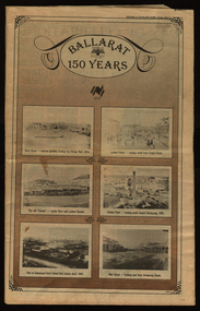
Newspaper, Ballarat 150 Years: Supplement to the Ballarat Courier, 1988, 17/03/1988
A supplement to celebrate 150 since the establishment of the Port Phillip Colony (Victoria).40 page newspaper published to celebrate the Sesquicentenary of Ballarat. Articles include: 1838-the pastoral period begins; First White Settlers arrive (Anderson, Winter, Yuille, Kirkland, Learmonth); Learmonths - Pioneer Settlers; The Rush to Ballarat; Last of the Aborigines; Eureka Affair Gains New Importance; Mining-After the rush; SMB - First Technical School; Clubs Play their Part; Ballarat Yuilles had Wealthy Ancestors; Town, Country Share a Close Relationship; Many Sides to Metals Industry; True Victorian City; Five Severe Recessions; Financiers to the Fore; Ready for War; City Rich in Sport Facilities; Visitors to most exciting place; No Place for a Nervous Lady; Theatres Provide Welcome Diversion for Mines; Might Achievers Among famous Citizens; Life Seemed Different After the War; Ballarat School of Mines Eastern Station Hotel; Memorial (Her Majesty's) Last of Many Theatres; Art Gallery at its Best; Pilgrimage to Yuille Cairn at Sebastopol Images include: Jelbart tractor; Sunshine Harvester; Bailey's Mansion; Pennyweight Hotel; Bridge Mall; Blue Riband Mine, Black Hill, Burrumbeet Shooting party; A wendouree rowing club; Motor Cycle Racing; Women bowlers, Queen Elizabeth; Gong Gong Methodist Church; Arbour day at Waterloo Farm, Smythes Rd; Gold panners (1890s); Ballarat Cricket Team (1902); William Peart; D'Angri's store; Sturt St Advertisements include: Rehfisch and Co.; UFS Dispensaries; Deutscher Mower Sales and Service; Haymes Paint; Cincotta's; Abraham's Sportscene; McK's; McKay Macleod; St John of God Hospital; Benjamins Real Estate; Ballarat Water Board; Cornell's Pharmacy; Laminex Industries; Coltman Mitre 10; Lal Lal Iron Mine; Heinz Bros; Crockers; Frank ford travel; S.J. Weir; Ludbrook Plumbing Service; Mars; Robert Sim Building Supplies, Frank Day; Sectrol Systems; Thornton Richardsballarat, anniversary, sydney abraham, cincotta, eureka, ballarat school of mines, mining, ballarat club, lal lal iron mine, ballarat rangers, victorian rifles, 3rd battalion victorian rifles, ballarat militia, white flat, celia scott, adelphi theatre, victoria theatre, montezuma theatre, charlie napier, juliamatthews, royal theatre, dick richards, henry sutton, eleanor lucus, martin hosking, newington estate, saleyards, g. gay & co, ballarat books, old benev' alleviated distress on goldfields -
 Federation University Historical Collection
Book, Historic Sites Survey: North Central Study Area, 1979, 1979
The North Central Study Area included the Shires of Avoca, Bet Bet, east Loddon, Goulburn, Untly, Kara Kara, Korong, Maldon, Marong, Metcalfe, McIvor, Newstead, Strathfieldsaye, Stawell, Talbot, Clunes, Tullaroop and Waranga. 153 page book with white plastic binding. It is an historic sites survey for the North Central Study Area commissioned by the Land Conservation Council, the Ministry for COnservation and the Australian Heritage Commission. castlemaine, mount alexander goldfield, maldon, percydale, warrenmang, moliagul, tarnagulla, stuart mill, the whipstick, whroo, rushworth, graytown ironbark forest, st arnoaud, new bendigo, landsborough, inglewood, kurting, wedderburn, wehla, kooroora, langham flat, mcintyre, rheola, diamond hill, fosterville, coliban water works, green gully, newstead, muckleford forest, costerfield, graytown, bailieston, waranga irrigaiton system, eucalyptus distillery, mia mia bridge, korokubeal township researce, concegella slate quarry, chewton, fryerstown, kingower, timor, talbot, majorca, carisbroook, clunes, st arnaud, taradale, icomos, dunolly, limestone, castlemaine slate quarry, harcourt granite, taradale railway viaduct, loddon united waterworks trust, gouldburn weir, carisbrook lock-up, history of tree planting in streets, history of public reserves, r.u. nicholls nurseryman, thomas lang, francis moss, ballarat botanical gardens, ballarat school of mines botanical gardens, lake wendouree, victoria park, ballarat, muont holled smith, ballaarat old cemetery planting, eastern oval, ballarat east botanical gardens, ballarat east town hall gardens, eureka stockade reserve, ballarat observatory plantings, yarrowee creek plantings, yarrowee bluestone channels, ballarat woollen mill, band and albion mullock heap, black hill plantings, yarrowee creek channels, canadian creek channel, specimen vale channel, poverty point reserve, union jack reserve buninyong, imperial mine, buninyong, victoria street plantings, bridge mall, sturt street gardens, ballarat avenue of honour plantings, white flat oval plantings, camp street, elms, burnt creek -
 Federation University Historical Collection
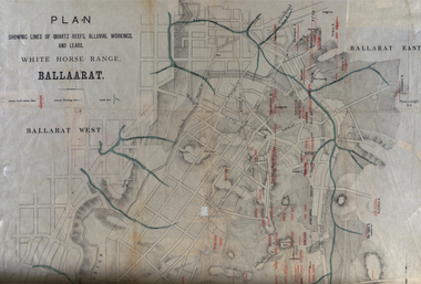
Plan, White Horse Range Ballarat, 1885, 06/1885
Two plans .1) Plan of the Ballarat Goldfields showing leads, rivers, streets and topography. Quartz reefs include: Yorkshire, Try Again, Promised Land, Western Slates, Norwegian, Robert's Lode, Finn's, Band and albion, Rothschild, Old Post Office, Queen Lode. Leads include: Navy jacks, Gays, Canadian, Prince Regent, Sailors Gully, White Horse, Little White Horse, Milkmans, Nightingale, Golden Point, Gravel Pits. Scale is 8 Chains to 1 inch .2) Plan showing lines of quartz reefs, alluvial workings and leads, White Horse Range, Ballarat. Leads include White Horse LEad, Little White Horse Lead, One Eye Gully, Terrible Lead, Sailor's Gully, Canadian Lead, Prince Regent Gully, Canadian Lead, Cavs Lead, Navy jacks Lead, Eureka Lead, Old Gravel Pits Lead, Gravel Pits Lead, Nightingale Lead, Malakoff Lead, Milkmans Lead, Redan Lead, Woolshed Lead, Jacksons Lead, Winters Lead, SCtochman's Lead, Canadian Lead. Reefs include: Promised Land, Daniash, Sir Garnet Wolsley, Norwegian, Rothschile, Band and Albion, Finns, Llanberis, Roberts Lode, Tynworths and Black Hill, Oregan, Yorkshire, Try Again, Yorkshire, Post Office, Clarke's, Western Slates, Black Slate, Danks Slates, Eastern Slates, Queen's Lode, Fire Brigade. Mines include Red Streak, New Chum, Tinworths, Woah Hawp, Normanby, Speedwell, Llanberris Extended, Llanberis, Last Chance, Major, Countess, Pioneer and a number of batteries along Main Road Hills include: Mount Clear, Pennyweight Hill, Sovereign Hillballarat, plan, white horse range, white horse, goldfields, mines, reefs, indicators, leigh river, cgt, tinworth, mining -
 Flagstaff Hill Maritime Museum and Village
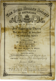
Award - Certificate of Merit, Royal Humane Society of Australia, James Patten, 21-05-1890
The Bronze Medal and Certificate of Merit of the Royal Humane Society of Australasia were awarded to James Patten for the bravery he displayed on 18th April 1890, and presented to him on 21st May 1890. The Royal Humane Society of Australasia was founded in 1874 with the aim to recognise those who risked their lives to save others and to assist those whose acts of bravery caused them or their surviving dependants to be disadvantaged in some way. The producers of the certificate were Fergusson & Mitchell, a Melbourne organisation established by 1858 that was an engraver, lithographer and printer. Details of the incident were published in the Argus, Saturday 19 April 1890, page 11 - "FATAL BOATING ACCIDENT, (BY TELEGRAPH FROM OUR CORRESPONDENT.), WARRNAMBOOL, FRIDAY A fatal boating disaster occurred in Lady Bay this morning, the victim being Joseph Lowe, licensee of the Bay View Hotel, South Warrnambool. The deceased, in company with two lads named James Ferrier and James Patten, went out in a small dingy to shoot musk ducks. The water was perfectly smooth, and the party were tempted to proceed as far as the mouth of the Hopkins River. In their eagerness they neglected to keep clear of the breakers, and were presently carried in on the crest of a large wave, and the boat cap sized within a cable's length of the shore, precipitating the occupants into the water. Patten and Lowe stuck to the overturned boat, Ferrier striking out for the shore, which he reached in an exhausted state. In the meantime his companions had been washed off the boat, and were struggling in the breakers. Lowe was unable to swim, and Patten kept him afloat, at the same time making gallant attempts to get him ashore, but finally had to leave him to his fate. Ferrier, seeing Lowe's danger, undressed and swam out, but became exhausted. Ferrier and Patten were both found in a fainting condition by persons who saw the catastrophe from the jetty, and ran along the beach to render assistance. Attempts were subsequently made to rescue Lowe's body, which could be seen washing abort in the surf. These proved unsuccessful, and no hope is now entertained of recovering it. Lowe was a smart young man, 28 years of age, and unmarried. He was formerly bar-man at the Commercial Hotel here, having been engaged in Melbourne...." The bronze medal and accompanying certificate of the Royal Humane Society of Australasia recognise the bravery of James Patten, a Warrnambool citizen who risked his life in the attempt to save the life of his friend Joseph Lowe.Certificate, cream paper, rectangular, decorative border and headings, printed and handwritten in pen and ink. Letterhead of The Royal Humane Society of Australasia. Awarded on 21st May 1890 to James Patten of Warrnambool. for his bravery on 18th April 1890.Print and writing includes - "The Royal Humane Society of Australia under the patronage of Her Majesty the Queen and their excellencies, the Governors of all the Australian Colonies and Fiji. At a general court of directors holden at the Offices of the Society Melbourne on the 21st day of May 1890, it was resolves that the courage and humanity displayed by James Patten, aged 20 years, labourer Warrnambool in attempting to rescue Joseph Lowe from drowning in the North Eastern bight of Lady Bay 18th April 1890. Call for the admiration of this court and justly, entitles him to the Bronze Medal of this society which is hereby awarded." Signatures [Secretary] and [President]flagstaff hill, warrnambool, flagstaff-hill, maritime museum, maritime village, shipwreck-coast, flagstaff hill maritime museum & village, bronze medal 1890, royal humane society of australasia, james patten, medal, australian award medal, commemorative medal, numismatics, life saving, lifesaving, rescue, bravery, drowning, joseph lowe, james ferrier, lady bay, hopkins river, boating accident, certificate of merit, lithograph, north eastern bight -
 Flagstaff Hill Maritime Museum and Village
Document - Plans, Lighthouse Keeper's Quarters Warrnambool, 1858-1909
The set of seven 1858 plans shows proposed plans for the original Lighthouse Complex that was built on Middle Island in 1858-1859. The whole complex was then transferred to Flagstaff Hill in 1871. The plan, dated 1909, is for proposed additions and repairs to the Quarters at Flagstaff Hill. The plan 'Alterations and Additions' shows alternate plans for changes to the quarters at the Flagstaff Hill location. This plan has no date. The Complex comprised the Lighthouse, the Lighthouse Keepers’ Quarters, the Store (now called the Chart Room) and a Privy, which was not included in these plans. The Keeper’s bluestone Quarters was a cottage divided into two compartments, one for each keeper and his family. The bluestone Store was divided into three; a store, a workshop an oil store (or office). The Privy comprised of a small building also divided into two separate, back-to-back toilets, one for each Keeper and his family. The Flagstaff Hill Keeper's Quarters have had extensions and additions at various times, and these have also been removed at various other times. THE PLANS - *Dec. 1858 (12/58) ‘Lighthouse Keepers Quarters No.2 Warrnambool’ (2375.01)* Public Works Office Melbourne – Front and Back elevations, sections, and floor plan. The drawing shows timber walls. [The floor plan is the closest plan to the current building, however, the walls are timber in this plan.] *Nov. 1858 – No.3 ‘Lighthouse Keepers Quarters Warrnambool’ (2375.02)* Office of Public Works, Melbourne – Back and End elevations and section through. The drawing shows stone walls. One side; Senior Keeper’s bedroom, living room and kitchen with storeroom. Another side; is the Assistant’s bedroom, living room and storeroom. *Nov. 1858 - No.4 ‘Lighthouse Stores Warrnambool’ (2375.03)* Office of Public Works – Front, Side and end elevations, centre section. The drawing shows stone walls. *Nov. 1858 – No.4, ‘Lighthouse Stores No. 2 Warrnambool’ (2375.04)* Office of Public Works – Front, side and end elevations, centre section. The drawing shows timber walls. *Nov. 1858 – ‘Details Lighthouse Keepers Quarters No. 2 Warrnambool’ (2375.05)* Public Works Office Melbourne. The plan shows the foundations, joists and eaves. The drawing shows timber walls. (Nov. 1858 – ‘No.4 ‘Lighthouse No. 2 – Warrnambool’ (2375.06)* Public Works Melbourne (Part of the paper is missing). This plan shows an octagonal tower, internal stairs, a balcony landing, and a weather vane on top. *November 1858 – No. 1, ‘Lighthouse – Warrnambool’ (2375.07)* Office of Public Works Melbourne. This plan shows a round tower, including the stairs, windows on the tower and the weather vane on the top. *4/3/9 [1909] – ‘Additions and Repairs, Lighthouse Quarters, Warrnambool, General Plan’ (2375.8)* Department of Public Works Melbourne’s official stamp is signed by Croft. It shows the floor plans of the Store, Upper Lighthouse and the Quarters. The Store building has three sections; a Store, Work-Shop and Office, with an internal wall between them and separate entries. The Quarters are divided into two dwellings. The Senior Keeper’s side on the left has fireplaces in two of the three bedrooms and there is a pantry and wash house. The Assistant’s side has no fireplaces in the bedrooms and there’s no pantry or washhouse. These plans include proposed changes to the buildings. The Senior Keeper’s Quarters would have a partition on bedroom 2, a bath with plumbing and drainage, a wall moved and a built-in side porch. The Store would also have a built-in porch. The undated plan 'Additions and Alterations' (2375.9) shows alternative arrangements for water tanks, plumbing and such. WARRNAMBOOL'S LADY BAY LIGHTHOUSES- In the 1800s ships sailing from England to Australia began to use Bass Strait as a faster route to Melbourne. Small navigation errors led to many tragic shipwrecks. From 1848 lighthouses were operating along Victoria’s southern coast as a guide for sailors. Coastal towns such as Warrnambool grew and the exchange of trade and passengers were of great benefit. However, the uncertain weather changes, relatively shallow waters and treacherous, hidden rocky reefs were not suitable for a Harbour and in the 1840s and 1850s there were many shipwrecks in the area, with some even stranded in its Lady Bay harbour. A jetty was built in 1850 and a flagstaff to guide seafarers was placed up high on what became known now as Flagstaff Hill. In November 1857 the Victorian Government recommended that Warrnambool Harbour had beacons and two lighthouses to guide vessels into and out of the Harbour safely. The white light of the Middle Island lighthouse was to be used for the first time on September 1, 1859. The red light of the Beach Lighthouse, a wooden obelisk structure, was first operated on March 25, 1860, but in 1868 this light was ‘discontinued’ due to it being too low. Melbourne’s Department of Public Works decided to relocate the Middle Island Lighthouse Complex - Lighthouse, Keeper’s Quarters, Privy, Store Room and even water tanks - to Flagstaff Hill. The lower obelisk was shortened, and a protruding gallery, railing, and external ladder were added, as well as the light from the Beach Lighthouse. A green guiding light was erected on the end of the jetty. The transfer of the Complex began in March 1871. Each shaped stone of the lighthouse was carefully numbered, removed then reassembled on Flagstaff Hill. In 1872 the well was sunk behind the Lighthouse Keeper’s Cottage. The Keepers and families had left Middle Island in April and moved to Flagstaff Hill in October 1871. Vessels entering Lady Bay align the Upper and Lower Lighthouse towers during the day and the lights at night. The Upper Lighthouse is a round tower, the Lower Light is square. The Lighthouses were categorised as harbour lights rather than coastal lights, so they remain under the control of the Victorian Government’s Ports and Harbours section. The lights were originally powered by oil, then acetylene gas, later by electricity, and then converted to solar power in 1988. In 1993 the solar panel was replaced by a battery charger. A decision was made in 1936 to replace the lighthouses’ lights with unattended lights that no longer required Keepers and Assistants. At least 29 Keepers had attended to the lighthouse from its opening in 1859 to when the last official Lightkeepers left In April 1916. The Warrnambool Harbour Board rented out the Quarters from 1916 to 1936. The Board closed down but the rentals continued with other unknown landlords. In the 1970s the Flagstaff Hill Planning Board was set up under the chairmanship of John Lindsay. The Board was to make recommendations to the Warrnambool City Council regarding the use of the buildings and the rest of the Crown Land on the site. The Flagstaff Hill Maritime Village opened in 1975 and began renovating the Cottage in stages, during which time evidence of a 1920s fire was found in the eastern section of the cottage. Additions of a porch on the west and a washroom on the east were made in the 1980s. The western part of the building is now a Shipwreck Museum and the east has returned to a late 19th-century Lighthouse Keeper’s cottage and includes the screen made by Assistant Lighthouse Keeper Thomas Hope during one of his two periods of service there. THE LIGHTHOUSE KEEPERS Lighthouse Keepers were responsible for keeping their Lighthouse’s lights shining at night. They kept a lookout for passing vessels and changes in weather. They were expected to clean, polish and maintain the equipment and buildings. They kept regular and detailed records of who was on watch, and the time the light was lit, trimmed and extinguished. They kept a journal about other events that occurred. They keep regular, accurate Meteorological Logs. It was expected that they were competent in Morse code signalling. They would be called to help in times of disasters and shipwrecks, and to give official statements about these events. Many Lighthouse Keepers also volunteered as members of the lifeboat crew. The Lady Bay lighthouses were officially classified as small, so the Keepers had the official titles of Senior Assistant Lighthouse Keeper and Assistant Lighthouse Keeper. They were employed by the Public Service and paid rent to live in the Lighthouse Quarters. They were compulsorily retired at the age of 60, with most receiving a superannuation payment. Despite their time-consuming duties, there was time to follow hobbies and crafts such as growing vegetables, playing musical instruments, making models of buildings including lighthouses, and crafting furniture pieces. An example of a keeper’s skills is the carved fire screen made by /assistant Keeper Thomas Hope in the early 20th century and displayed in the Lighthouse Keeper’s cottage at Flagstaff Hill. The last occupants of the Middle Island Complex were Senior Keeper Robert Deverell, his Assistant Keeper, Andrew Farncombe, and their families. They all became the first occupants at the Lady Bay Lighthouse Keepers’ Quarters on Merri Street. The Warrnambool Lighthouse Complex plans are the origin of what is now the Lady Bay Lighthouse Complex. They are a record of the people, process and departments involved in bringing the complex into fruition. The plans are significant to the Complex, which is now listed on the Victorian Heritage Register, H1520, for being of historical, scientific (technological) and architectural significance to the State of Victoria. The Complex is significant as an example of early colonial development. The plan are significant for their connection with the important navigational function of the Lighthouses, a function still being performed to this day. The plans are also significant as an example of a product from the Public Works Department in Victoria in the mid-to-late 19th century. The structures built to these plans still stand strong. Plans for the Lighthouse Complex in Warrnambool, including Lighthouses, Keeper's Quarters and Stores. Seven of the plans are on thin fragile paper, one is on thicker, stronger paper. The drawings have been made in pens coloured red and black. They originate from Public Works in Melbourne. Seven were drawn in 1858, one in 1904, the other is not dated.Dec. 1858 - Lighthouse Keepers Quarters No.2 Warrnambool. Public Works Office Melbourne. Nov. 1858 - No.3 ‘Lighthouse Keepers Quarters Warrnambool. Public Works Office Melbourne. Nov. 1858 - No.4 ‘Lighthouse Stores Warrnambool. Office of Public Works. Nov. 1858 - No.4, ‘Lighthouse Stores No. 2 Warrnambool. Office of Public Works. Nov. 1858 - Details Lighthouse Keepers Quarters No. 2 Warrnambool. Public Works Office Melbourne. Nov. 1858 - No.4 ‘Lighthouse No. 2 – Warrnambool. Public Works Melbourne. Nov. 1858 - No. 1, Lighthouse - Warrnambool. Office of Public Works Melbourne. 4/3/9 [1909] - Additions and Repairs, Lighthouse Quarters, Warrnambool, General Plan. Department of Public Works Melbourne. SIGNED "Croft" "15A" on reverse [no date] - Lighthouse Quarters Warrnambool, Additions and Alterations. "9A" on reverseflagstaff hill, warrnambool, lighthouse keeper's cottage, lighthouse residence, lighthouse, plans, public works, melbourne, flagstaff hill maritime museum, maritime museum, shipwreck coast, flagstaff hill maritime village, chart room, quarters, privy, middle island, beach lighthouse, obelisk, lighthouse keeper, assistant keeper, lighthouse complex, lady bay, lady bay complex, keepers, upper lighthouse, lower lighthouse, ports and harbours, cottage, harbour board, flagstaff hill planning board, meteorological record, robert deverell, andrew farncombe, warrnambool port, warrnambool harbour, residence, alterations, repairs, department of works -
 Flagstaff Hill Maritime Museum and Village
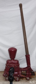
Equipment - Pump, circa 1930's - 1940's
This pump is an Ajax Type L2 Series A model, made and sold by McPherson’s Pty Ltd of Melbourne circa 1930’s to 1940’s, is a mechanical, hand operated, constant flow pressure pump. It would have been used to pump fluids from one area to another, for example from a dam to a tank or used as a bilge pump on a small vessel, mounted on the vessel’s bulkhead, floor or deck. This type of hand pump is sometimes called a ‘Reciprocating Suction Pump’. It has a mechanical pumping action of the lever moves the piston inside the pump up and down. The water is lifted from below the pump through the inlet pipe and into the pump’s cylinder. This action causes the lower valve to close and the piston’s valve opens and the pressure within the pump forces the water out of the pump through the exit pipe. The limitation of this type of pump is that it can only raise the water a maximum of about 7 metres from beneath the ground and yields 24-26 Litres per minute. This type of pump could be used for many purposes such as pumping water or fuel. McPherson’s 1940’s advertisement proclaims “For all jobs on the land – irrigation, spraying, tank, plumbing, fire-fighting – there’s a suitable “Ajax” pump. Send us the details of you pumping problem. Our Expert’s advice will help you choose the right pump – the one that will give you most years of PROFITABLE PUMPING.” (The Australasian (Melbourne) Sat. 26th October 1940.) McPherson’s Pty Ltd, the manufacturer, advertised a similar pump to this one in The Australasian (Melbourne) in 1936, calling it the Ajax Double Acting Hand Pump. In 1942 another advertisement advised that a representative for a fire-fighting equipment supplier was visiting the western district of Victoria. The company could now supply double-action two-spray Ajax pumps at lower prices than similar pumps the district had recently purchased from Adelaide. McPHERSON’S FOUNDER and COMPANY TIMELINE 1860 – Thomas McPherson, a Scottish immigrant (c. 1853 ), founded McPherson’s in Melbourne, supplying pig iron (lead ingots imported as ballast in ships) to local manufacturers. 1882 – Thomas McPherson established a warehouse in Collins St Melbourne and included tools, steam fittings and machinery in his wares. The business expanded to include steam saw mills and became known as Thomas McPherson and Sons (William Murray and Edward). 1888 – Thomas passed away and his sons inherited the business. In 1896 William Murray became the sole proprietor after his brother Edward’s death. 1900 – The firm expanded, establishing Acme Bolt Company to manufacture nuts and bolts. 1912 – McPhersons Pty Ltd established a machinery warehouse and showroom in 554-556 Collins St Melbourne. McPherson’s went on to establish branches in Sydney (1911), Adelaide (1921) and Perth (1930) 1917 - McPherson’s supplied ‘dog spikes’ for the transcontinental railway, running from Eastern to Western Australia. 1918 – A tool works set up in Kensington, Melbourne, manufacturing Macson lathes and made machine tools that previously had to be imported. 1924 – The Bolt Works was transferred to a new building in Melbourne. McPhersons began making pumps. 1929 – McPherson retired. His son (Sir) William Edward McPherson (known as ‘WE’), was born in Hawthorne, Melbourne, in 1898. After his education he began work in his father’s Melbourne hardware and machinery business He took over as governing director when his father retired. 1929-1932 – McPherson’s supplied thousands of tons of rivets from its Richmond (Melbourne) Bolt Works for the construction of the Sydney Harbour Bridge. 1936 – McPherson’s Pty Ltd is advertising Ajax Pumps in newspapers 1934 – McPhersons purchased the property adjoining the warehouse in Collins Street, and during 1935-1936 built a new office and showrooms on the site of 546-445 Collins St. 1939 - McPherson’s acquired the Tool Equipment Co. Pty. Ltd and Associated Machine Tools Australia Pty Ltd was formed to separate McPherson’s machine-tool manufacturing and merchandising interests. 1939 – Ajax Pump Works, a foundry and pump manufacturing plant, was established in Tottenham, Melbourne, and the Ajax Bolt and Rivet Co Pty Ltd began manufacturing in New Zealand. 1944 - McPherson’s became a public company, McPherson’s Ltd. 1948 - The Ajax Pump Foundry opened at Kyneton, Victoria and in the post war years it grew to became a large manufacturer. 1980’s – Ajax Pumps brochure lists the address as 6 Buckhurst St, South Melbourne, Vic 3205 with the Telephone number 03 669 3588 1988 - Ajax Pumps acquired the Forrers Company, which was established in 1921. Manufacturing in Ipswich, Queensland, specialising in submersible sewage pumps. 1991 – KSB Ajax was formed, bringing together the companies KSB and Ajax Pumps 1993 – Manufacturing was moved to state-of-the-art premises in Tottenham, Victoria 2001 - The Forrers facility was moved to Tottenham. 2007 - Company name KSB Ajax Pumps was changed to KSB Australia Pty Ltd. 2009 - KSB Australia opened a branch in Townsville, Queensland. 2011 - KSB Australia moved to its dedicated Water and Waste Water Competence Centre in Bundamba, Queensland. DISPLAY OF THIS AJAX PUMP This pump was installed at Flagstaff Hill Maritime Village as part of a working display in the village by the Friends of Flagstaff Hill, in acknowledgement of the dedicated involvement of one of its long serving members, Bob Crossman. The display was officially opened 31st March 2018 and incorporates a restored Furphy Tank and Water Pipe Stand. The pump is used to draw water from the lake, through the water stand pipe and into the reconditioned Furphy Tank. This Ajax pump made by McPherson’s Pty Ltd is significant for its association with McPherson’s, a prominent manufacturer of hardware in Victoria. McPherson’s is famous for supplying ‘dog-spikes’ for the transcontinental railway (eastern to western Australia, 1917) and rivets for the Sydney Harbour Bridge (1929-1932). The Ajax pump is also of significance because of its association with McPherson’s Governing Director (Sir) William McPherson, former premier and treasurer in Victoria 1928-1929. The former McPherson’s Pty Ltd building in Collins Street Melbourne is now on the Victorian Heritage Register VHR H0942 This pump is representative of mechanical pumps popular in the early to mid-1900’s and still used today. Hand operated pressure pump, double acting. Cast metal case, painted red, with steel hose attachments and long metal lever. Pump is bolted to wooden plank. Model of pump is AJAX, Type L2, Series A pump. Embossed on lower section of pump "L2 - 10", "L2 - -1", "AJAX" “(?) –2-1” Embossed on lower handle “3-7” “L – 4” Embossed on attached plate “FOR SPARE PARTS / TYPE L2 / SERIES A / PUMP ASSEMBLED BY T R” Manufactured by McPherson’s Pty Ltd of Melbourne circa 1930’s - 1940’s.flagstaff hill, warrnambool, flagstaff hill maritime museum, shipwreck coast, flagstaff hill maritime village, great ocean road, ajax pump works tottenham melbourne, ajax pump factory kyneton, william edward mcpherson, thomas mcpherson of melbourne, mcpherson’s pty ltd melbourne, acme bolt company, tool equipment co. pty. ltd, associated machine tools australia pty ltd, ajax bolt and rivet co. pty ltd new zealand, forrers company ipswich queensland, ksb ajax pumps, ksb australia pty ltd, macson lathes, tool manufacturer early to mid- 20th century, ajax double acting hand pump, ajax type l2 series a pump, qisjax pumps, water pump 1940’s, fuel pump 1940’s, hand operated constant flow pressure pump, reciprocating suction pump, agricultural hand pump, plumber’s hand pump, portable hand pump -
 Flagstaff Hill Maritime Museum and Village
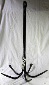
Functional object - Anchor, Henry P Parkes & Co, 1885 - 1904
In about 1820 Henry Pershouse Parkes, from Dudley, established the Tipton Green Chain and Anchor Works (Staffordshire). The firm’s products included cables, chains, anchors and all kinds of forgings. In 1851 some tests were carried out on the company’s chains to demonstrate the tensile strength and fibrous toughness of the iron used in their production. The iron used on this occasion was supplied by Summer Hill Iron Works. Some of the chains were exhibited at the Great Exhibition in 1851 and also at the 1855 French Exhibition in Paris, where they won a prize medal. Henry Pershouse Parkes died in 1867 and appears to have been succeeded by his son, who had the same name. In 1867 the firm produced the largest anchor in the world, at that time. It was built for Brunel’s S. S. Great Eastern to the patented design of Joseph Beterley, of Liverpool. The anchor, which weighed eight tons was twenty six and a half feet long and cast from iron supplied by Bloomfield Iron Works. It was tested at Tipton Proving House and found to be able to stand a strain of 100 tons. Henry Pershouse Parkes junior went into partnership with Alexander Stewart Ross to form Henry P. Parkes and Ross. The partnership came to an end in 1885 and the company became Henry P. Parkes & Company. In 1904 the business was sold and became H. P. Parkes and Company, under the control of N. Hingley & Sons Limited, of Netherton. In 1944 the company’s name was changed to Richard Sykes and Son Limited, then in 1947 it became H. P. Parkes & Company Limited. The business went into liquidation in 1966.The item is significant as an early example of a well known prize winning British anchor and chain maker from the mid 19th century. The company name on the anchor indicate the period of manufacture making it a significant item prized today by collectors.Anchor 5 pronged metal with loop at bottom to attach anti-snag rope. Long shank painted black. Label attached "Henry P Parker and Co"flagstaff hill, warrnambool, flagstaff-hill, flagstaff-hill-maritime-museum, maritime-museum, shipwreck-coast, flagstaff-hill-maritime-village, five pronged anchor, henry p parkes & co, tipton green chain and anchor works -
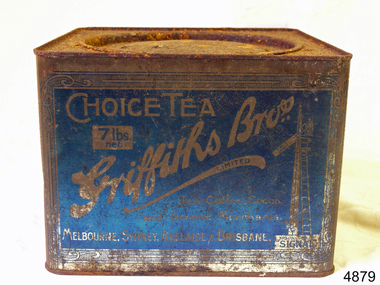 Flagstaff Hill Maritime Museum and Village
Container, Griffiths Bros, 1900 - 1940
In 1873, English grocer James Griffiths migrated to Melbourne with his wife and cousin in order to start a tea business. By 1875 Griffiths Brothers Teas had become a sensation, providing tea, coffee, cocoa and chocolate all over Australia. The Sydney outlet of the Melbourne-based company was built in 1915. In a memorable advertising campaign, a series of Griffiths signs were situated at varying intervals along the rail lines on fences and building, designed to allow travellers to count down the miles until they could drink up. In 1925, James Griffiths was killed by a train and the tea company was sold to Robur Tea, which itself lasted until 1974. Griffiths’ death meant downsizing within the company with the Sydney building being transferred to the Sydney City Council, who then leased it back to Griffiths Teas. The tea craze was over by 1965, and Griffiths relinquished control of the building to a variety of tenants. Griffiths tea became an intrical part of Australian life, during the late 19th to mid 20th century. The company became a household name through the clever use of outdoor advertising with their blue and white enamel “Griffiths Tea” signs. These were visible Australia wide on railway fences, stations and other buildings. Griffiths signs let the rail travelers know the distance to where their tea could be enjoyed, with distances being shown as “miles to Griffiths Tea”, These signs were well known along the eastern states railway lines. Tea container tin Griffiths blue tin with round lid, not hinged. 7lbs net Choice Tea Griffith Bros 7lb net in white on a blue labelflagstaff hill, warrnambool, shipwrecked-coast, flagstaff-hill, flagstaff-hill-maritime-museum, maritime-museum, shipwreck-coast, flagstaff-hill-maritime-village -
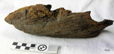 Flagstaff Hill Maritime Museum and Village
Wood Sample, 1854
This timber fragment is from the shipwreck of the SCHOMBERG (1855). The bow of the ship broke off after an unsuccessful salvage attempt to tow her off the Peterborough reef. At the wreck-site the submerged hull points north towards the beach but the front section is missing. Parts of the bow have been carried away by the eastward bearing ocean currents and have come ashore on the western coast of New Zealand’s South Island. Don Charlwood writes in Wrecks & Reputations (1977) that in 1871 “a piece of wreckage over 20 feet long and 12 feet wide was brought out” by land from its remote location at Tauperika Creek. In 1875 “an even larger section was brought out by sea”. It was suggested at the time that these relics of a large wooden sailing ship were from the wreck of the SCHOMBERG some 20 years earlier on the Victorian coast. “To corroborate the theory”, Charlwood continues, “a piece was sent to Halls of Aberdeen [the ship’s builders in Scotland]. They identified it as having come from the ship they had launched with such pride in 1852.” Charlwood, whose great-grandparents were passengers on the SCHOMBERG’s fateful maiden voyage, acquired some samples of the wreckage timber recovered in New Zealand, and brought them back with him to Australia. In 1976 “comparison was made of timbers from the New Zealand find and timber from the remains of the hull at Peterborough. They proved to be from the same ship.” The extraordinary journey of these pieces of wood from the once mighty clipper ship SCHOMBERG came to an end in 1984, when they were given to Flagstaff Hill by the author, and reunited with other shipwreck timbers and copper bolts from the vessel that are on display at the Maritime Village. The shipwreck of the SCHOMBERG is of State significance - Victorian Heritage Register S612The artefact is a small piece of wood that was broken from the timbers of the shipwreck of the SCHOMBERG (1855) and carried by the eastern currents to New Zealand (1875). It has 2 drilled holes that show faint screw marks and no metallic residue (possibly for patent treenails). The top surface is rounded, of a dark colour, and showing clear grains that have been worn smooth by the action of the sea. There is a reddish stain on the timber where breakage has occurred. The wood appears to have been strong in its original condition but is now light to lift and soft and crumbly at its exposed edges. The artefact is in fragile condition.flagstaff hill, warrnambool, shipwrecked-coast, flagstaff-hill, flagstaff-hill-maritime-museum, maritime-museum, shipwreck-coast, flagstaff-hill-maritime-village, schomberg, shipwreck timber, don charlwood, ‘wrecks & reputations’ -
 Flagstaff Hill Maritime Museum and Village
Award - Medal, James Patten, 18-041890
The Bronze Medal and Certificate of Merit of the Royal Humane Society of Australasia were awarded to James Patten for the bravery he displayed on 18th April 1890, and presented to him on 21st May 1890. The Royal Humane Society of Australasia was founded in 1874 with the aim to recognise those who risked their lives to save others and to assist those whose acts of bravery caused them or their surviving dependants to be disadvantaged in some way. Details of the incident were published in the Argus, Saturday 19 April 1890, page 11 - "FATAL BOATING ACCIDENT, (BY TELEGRAPH FROM OUR CORRESPONDENT.), WARRNAMBOOL, FRIDAY A fatal boating disaster occurred in Lady Bay this morning, the victim being Joseph Lowe, licensee of the Bay View Hotel, South Warrnambool. The deceased, in company with two lads named James Ferrier and James Patten, went out in a small dingy to shoot musk ducks. The water was perfectly smooth, and the party were tempted to proceed as far as the mouth of the Hopkins River. In their eagerness they neglected to keep clear of the breakers, and were presently carried in on the crest of a large wave, and the boat cap sized within a cable's length of the shore, precipitating the occupants into the water. Patten and Lowe stuck to the overturned boat, Ferrier striking out for the shore, which he reached in an exhausted state. In the meantime his companions had been washed off the boat, and were struggling in the breakers. Lowe was unable to swim, and Patten kept him afloat, at the same time making gallant attempts to get him ashore, but finally had to leave him to his fate. Ferrier, seeing Lowe's danger, undressed and swam out, but became exhausted. Ferrier and Patten were both found in a fainting condition by persons who saw the catastrophe from the jetty, and ran along the beach to render assistance. Attempts were subsequently made to rescue Lowe's body, which could be seen washing abort in the surf. These proved unsuccessful, and no hope is now entertained of recovering it. Lowe was a smart young man, 28 years of age, and unmarried. He was formerly bar-man at the Commercial Hotel here, having been engaged in Melbourne ..." This medal recognises the bravery of James Patten, a local citizen who risked his life to save the life of his friend Joseph Lowe whilst at sea and was recognised for this act by the Royal Humane Society of Australasia.Medal awarded to James Patten by the Royal Humane Society of Australasia for his bravery on18 April 1890 and presented to him on 21 May 1890. Bronze medal in hard black rectangular case. Lid and base have centre hinge and brass spring button catch. Case is padded and lined with blue silk and has a fitted hook. The round medal has a bronze bar with pin closure, dark blue, braided ribbon with brass swivel mount. The case has a gold embossed rectangular border on the lid and base. Embossed inscription on lid. The obverse shows a woman on the left in long robe placing a wreath on the head of a kneeling man at right, with the five stars of the Southern Cross constellation above his head. A motto is inscribed around the edge. The reverse has inscriptions around the edge, a wreath of two overlapping olive branches, and engraved text.OBVERSE: Embossed around "VIRTUTE PARATUM" REVERSE: Embossed on the medal around the edge "ROYAL HUMANE SOCIETY OF AUSTRALASIA INSTD. A.D. 1874", in the centre "AWARDED TO" Engraved in the centre "James Patten/ 18th April / 1890" CASE LID: "PRESENTED BY / THE ROYAL HUMANE SOCIETY / OF AUSTRALASIA / TO / JAS. PATTEN. / 21ST MAY 1890."flagstaff hill, warrnambool, flagstaff-hill, maritime museum, maritime village, shipwreck-coast, flagstaff hill maritime museum & village, bronze medal 1890, royal humane society of australasia, james patten, medal, australian award medal, commemorative medal, numismatics, life saving, lifesaving, rescue, bravery, drowning, joseph lowe, james ferrier, lady bay, hopkins river, boating accident, certificate of merit, north eastern bight -
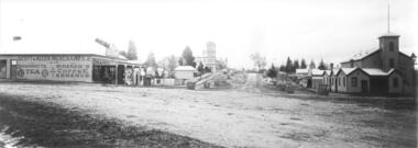 Yarra Glen & District Historical Society
Black and white photographs, Bell Street Yarra Glen looking north c.1900
View of Bell Street Yarra Glen looking north from junction with King Street. On left hand side is Scott & Allen's General Store, next to that is a bootmaker, then the house of Charles Bath, the Grand Hotel and the Colonial Bank building. On the eastern side of Bell Street (right hand side of photograph) is the Victoria Hall. Beyond that is W.J.Dawborn's General Store, then Smith's bakery, and on top of the hill the trees surrounding 'Point Pleasant' owned by the Herbert family.yarra glen, point pleasant, grand hotel, victoria hall, bell street, charles bath, general store, colonial bank, bank building, w j dawborn, scott and allen, bootmaker, smith, bakery, baker s shop, herbert -
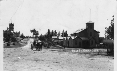 Yarra Glen & District Historical Society
Black and white postcards, Bell St Yarra Glen c.1900
Photograph taken from the junction of Bell and King Streets looking north up Bell Street early 20th century. On the eastern side of Bell Street (left hand side of photograph) is the Victoria Hall. Behind the hall is a newsagency and behind that is the bakery. The pine trees at the top of the hill are at 'Point Pleasant', home of the Herbert family. On the western side of Bell Street can be seen the Grand Hotel and the Colonial Bank. The street trees are in wooden tree guards. In the middle foreground are two men in a buggy drawn by two horses.On back of the postcard at the top "POST CARD". Under those words are "CORRESPONDENCE" on the left and "ADDRESS ONLY" on the right.yarra glen, point pleasant, victoria hall, horse drawn vehicle, bell street, bakery, herbert, newsagency, newsagent, bakers shop, horse buggy, buggy -
 Federation University Historical Collection
Photograph, Marilyn Jeffs, Hotels of Ballarat, 2019
Numerous photographs take by Marilyn Jeffs for use on the Ballarat and District Industrial Heritage Wikihotels, ballarat, royal mail hotel, peter lalor hotel, the george hotel, x on albert hotel, cattleyards inn, market hotel, bunch of grapes hotel, argyle hotel, atlantic hotel, ballarat hotel, black hill hotel, blue bell hotel, bluebell hotel, brown hill hotel, canberra hotel, carboni, carboni's italian kitchen, eureka stockade hotel, carriers arms hotel, eastern station hotel, centenary hotel, craig's hotel, eastern railway hotel, freight bar, athletic club hotel, grapes hotel, munster arms hotel, golden city hotel, golf house hotel, irish murphy's, camp hotel, lake view hotel, la porchetta, southern cross hotel, the mallow hotel, meaghers hotel, millers arms, miners tavern hotel, miner's tavern hotel, provincial hotel, north britain hotel, north star hotel, oscar's hotel, criterian hotel, park hotel, prince regent house, prince regent hotel, sport globe, sporting globe, jacksons hotel, railway hotel, pwtn, pater lalor hotel, royal highlander hotel, queen's head hotel, red lion hotel, robin hood hotel, military arms hotel, royal oak hotel, western hotel, imperial hotel, unicorn hotel, union hotel -
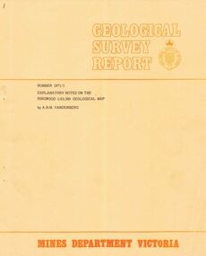 Ringwood and District Historical Society
Booklet - Geological Survey Report, Explanatory Notes on Ringwood, Victoria by A.H.M. Vandenberg, 1971
Geological description of the eastern and southeastern suburbs of Melbourne, Dandenong Ranges, Harkaway Hills and the Silvan and Macclesfield districts. -
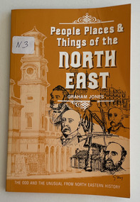 City of Moorabbin Historical Society (Operating the Box Cottage Museum)
Book, Jones, Graham, People, places & things of the North East, 1981
128 p. : ill.non-fictionvictoria, history -
 Flagstaff Hill Maritime Museum and Village
Container - Tea Container, Griffiths Bros, 1900 - 1940
In 1873, English grocer James Griffiths migrated to Melbourne with his wife and cousin in order to start a tea business. By 1875 Griffiths Brothers Teas had become a sensation, providing tea, coffee, cocoa and chocolate all over Australia. The Sydney outlet of the Melbourne-based company was built in 1915. In a memorable advertising campaign, a series of Griffiths signs were situated at varying intervals along the rail lines on fences and building, designed to allow travellers to count down the miles until they could drink up. In 1925, James Griffiths was killed by a train and the tea company was sold to Robur Tea, which itself lasted until 1974. Griffiths’ death meant downsizing within the company with the Sydney building being transferred to the Sydney City Council, who then leased it back to Griffiths Teas. The tea craze was over by 1965, and Griffiths relinquished control of the building to a variety of tenants. Griffiths tea became an intrical part of Australian life, during the late 19th to mid 20th century. The company became a household name through the clever use of outdoor advertising with their blue and white enamel “Griffiths Tea” signs. These were visible Australia wide on railway fences, stations and other buildings. Griffiths signs let the rail travelers know the distance to where their tea could be enjoyed, with distances being shown as “miles to Griffiths Tea”, These signs were well known along the eastern states railway lines. Tea container tin Griffiths blue tin with round lid, not hinged. 7lbs net Choice Tea Griffith Bros 7lb net in white on a blue labelflagstaff hill, warrnambool, shipwrecked-coast, flagstaff-hill-maritime-museum, maritime-museum, shipwreck-coast, flagstaff-hill-maritime-village, griffiths bros, tea container, tin tea container -
 Flagstaff Hill Maritime Museum and Village
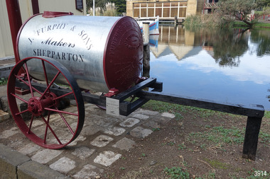
Vehicle - Furphy Water Cart, J. Furphy & Sons, c. 1942
This horse-drawn, two-wheeled cart with a tank, is known as a Furphy Farm Water Cart that was made in Shepparton, northern Victoria, c. 1942. John Furphy (1842-1920) was born in Moonee Ponds, in 1842 to Irish immigrant parents and subsequently raised in the Yarra Valley before the family moved to Kyneton in central Victoria, where he completed an apprenticeship with the firm Hutcheson and Walker. Murphy began operations of his own at a site on Piper Street in Kyneton in 1864. He relocated for a business opportunity and founded the first blacksmiths and wheelwrights shop in the newly surveyed town of Shepparton in 1873. Furphy invented many farming tools and machines including a patented grain-stripper, and won awards at the 1888-89 Melbourne International Exhibition. His most famous invention is the Furphy Farm Water Cart, designed in the 1880s, at a time when water for most households and farms was carted on wagons in wooden barrels. The Furphy’s water cart is a single item that combines a water metal tank and a cart. The design of the cart was simple yet effective, and became popular very quickly and established itself as a vital piece of farming equipment. The water cart has had a number of words cast into its ends over many years. References to the foundry’s location in Shepparton, as well as advertising of other products also manufactured by J. Furphy & Sons were present on the ends. However, the most significant set of words to feature on the tank, was a poem encouraging continual improvement: ‘Good Better Best, Never Let it Rest, Until your Good is Better, And your Better Best’. During The Great War (1914-1918), the water cart was used by the Australian militarily at a large AIF (Australian Imperial Force) camp in Broadmeadows (Melbourne) where thousands of men were camped for months, before being transported aboard. Furphy Water Carts provided water to the troops, and were usually placed near the camp latrines, which was one of the few places the troops could share gossip and tall tales away from the prying eyes and ears of their officers. The water cart drivers were also notorious sources of information, despite most of their news being hearsay, or totally unreliable. By the time the men of the AIF were in engaged in combat on the Gallipoli Peninsula and the Western Front, the carts used for water supply had no markings and became simply referred to as Furphys. This owed as much to the coining of the term ‘Furphy’, Australian slang for suspect information or rumour. After a number of decades as principally a soldier’s word, 'Furphy' entered the broader Australian vernacular and was used mainly by the political class until recently when the term was taken up by a Australian brewer as a beer brand. This Furphy Water Cart was purchased by Friends of Flagstaff Hill in 2014. The support of local individuals, organisations and businesses enabled its restoration and later its installation alongside the existing late-19th century water pipe stand and 1940s hand pump The Furphy Farm Water Cart is of historical significance as it represents a famous Australian time-saving and energy-saving invention of the 1880s, replacing the labour intensive activity of collecting and dispensing water from barrels and casks on the back of carts. The water cart’s connection with manufacturing companies J. Furphy & Sons and Furphy Foundry are significant for being early Australian businesses that are still in operation today. Furphy carts are of military significance for the role they played during The Great War (1914-1918) in Australian army camps, and theatres of war in Europe and the Middle East, to supply the AIF troops with fresh water. A wooden framed, two-wheeled, horse-drawn cart, fitted with a horizontally mounted, cylindrical metal tank. The tank is made of rolled, sheet steel with a riveted seam, and cast iron ends with cast iron ends. The spoked metal wheels have fitted flat iron tyres and metal hubs. A metal pipe is joined to the outlet. The tank is silver coloured, the ends, wheels and trims are crimson, and the script lettering on tank sides is black. There are inscriptions on the tank, ends, and hubs. The water tank was made in 1942 in Shepparton, Australia, by J. Furphy & Sons and has a capacity of 180 gallons (848 litres). Hub perimeter, embossed “J. FURPHY & SONS” “KEEP THE / BOLTS TIGHT” Hub centre embossed [indecipherable] Tank, each side, painted “J. FURPHY & SONS / Makers / SHEPPARTON” Tank ends, embossed – “FURPHY’S FARM WATER CART” “BORN ABOUT 1880 – STILL ‘GOING STRONG’ 1942” “j. FURPHY & SONS / MAKERS / SHEPPARTON - VIC “ “S - - - - - L MANUFACTURERS” [SPECIAL] “SPIKE ROLLERS” “SINGLE TREES” “PLOUGH WHEELS” “IRON CASTINGS” “LAND GRADERS” “STEEL DELVERS” “CAST IRON PIG” “CHAIN YOKES” “GOOD – BETTER – BEST / NEVER LET IT REST / TILL YOUR GOOD IS BETTER / AND YOUR BETTER – BEST” Image [Stork carrying a baby] above shorthand, transcribed "Produce and populate or perish" Image [Furphy Pig Feeder] beside ‘Cast Iron Pig’ Shorthand, transcribed “"Water is the gift of God but beer and whiskey are concoctions of the Devil, come and have a drink of water"warrnambool, flagstaff hill maritime museum, water cart, furphy cart, furphy tank, furphy farm water cart, furphy, john furphy, john furphy & sons, furphy foundry, kyneton, shepparton, mobile water tank, jinker, hutchinson & walker, blacksmith, farm equipment, implement maker, tool maker, horse drawn, stork and baby, good, better, best, barrel, tank, first world war, wwi, eastern front, gallipoli, j furphy & sons -
 Bendigo Historical Society Inc.
Document - ALBERT RICHARDSON COLLECTION: VICTORIA HILL MINES
Two page handwritten document titled 'Victoria Hill Mines, Dickers M.R. 23.11.1861. Wittschiebe and Co. Claim. Next north to No. 2, Midway Company' Transcribed by Albert Richardson. Extract from text: 'There are reefs passing through this ground at small intervals in every part of this claim, they all dip north. The mass of leaders struck in No. 4 (shaft) yielded, on an average about 1 1/2 ounces to the ton to the amount, in all, of about 12,000 pounds. From the eastern Victoria, the present proprietors extracted in nine months 55,000 pounds worth of gold.' Owners of mine. Messrs A. Witrtschiebe, A. Sagasser, F. Meison, A. Urban, H. Koch, C. Killian and A. Rudolf. Document details the claim, the shafts sunk, their depth, issues re workings and gold found.Albert Richardsonbendigo, mining, wittschiebe & co. claim -
 Bendigo Historical Society Inc.
Document - REMINISCENCES OF MR JACK HATTAM: ORAL HISTORY ASSIGNMENT
Reminiscences of Mr Jack Hattam - 38 pp. Oral History assignment by Phyllis Smithson 1982. Introduction: ''This paper is a transcript of a taped interview with Mr Jack Hattam with annotations to augment his comments by Phyllis Smithson. Mr Hattam did not know a lot about his forebears so I have endeavoured to recreate some of the background and conditions his grandparents and relations would have encountered''. Bibliography and family tree.Jack Hattamperson, individual, jack hattam, st just point, long gully, voictorian quarts mining company, white hills cemetry, mr henry hattam mayor of bendigo, midway company, victoria reef, energetic ompany, bird's reef company, great eastern company, (sedgewick), hercules company, frank cusack, bendigo creek, bendigo valley, grub-staking, hopetoun street, john and ellen o'connell, hunters brewery. -
 Monbulk RSL Sub Branch
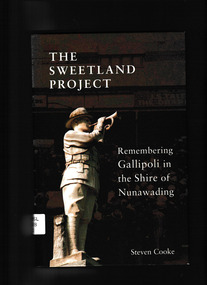
Steven Cooke, The Sweetland Project : remembering Gallipoli in the Shire of Nunawading, 2015
A chance discovery made on a tour of Anzac Cove provided an immediate link between Gallipoli and Melbourne’s Eastern Suburbs. In the lead up to the Centenary of Anzac, ‘The Sweetland Project’ (named after a Box Hill man, Stephen Sweetland) became a broader search for the connections between Gallipoli and the former Shire of Nunawading, revealing 27 men from the former shire who died during the Gallipoli campaign. This book traces their stories and the reaction to the Great War of the local community, and shows how personal and collective memories of their experiences still resonate today.Index, bibliography, notes, ill, p.211.non-fictionA chance discovery made on a tour of Anzac Cove provided an immediate link between Gallipoli and Melbourne’s Eastern Suburbs. In the lead up to the Centenary of Anzac, ‘The Sweetland Project’ (named after a Box Hill man, Stephen Sweetland) became a broader search for the connections between Gallipoli and the former Shire of Nunawading, revealing 27 men from the former shire who died during the Gallipoli campaign. This book traces their stories and the reaction to the Great War of the local community, and shows how personal and collective memories of their experiences still resonate today.world war 1914-1918 - campaigns - gallipoli, gallipoli campaign - personal recollections -
 Buninyong & District Historical Society
Photograph - Photograph colour of Green Hill, View of Green Hill from Ballarat Institute of Advanced Education (Federation University) site, 1968
... Mt. Helen Site - Eastern end towards Green Hill 1968... Landscape Mt. Helen Green Hill Mt. Helen Site - Eastern end towards ...Colour photograph of site of Ballarat Institute of Advanced Education 1968 showing Green HillThe construction of the Mt. Helen campus in the 1970s in the predominately rural area was an important milestone in the expansion of tertiary education in the Central HighlandsColour photograph from Ballarat Institute of Advanced Education construction site toward Green Hill 1968Mt. Helen Site - Eastern end towards Green Hill 1968education, ballarat institute of advanced education, federation university, landscape, mt. helen, green hill -
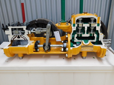 Puffing Billy Railway
Sectioned Tangye Steam Operated Water Pump, 1900s
... and Seymour, and had constructed a large gasworks at Box Hill... at Box Hill to supply the eastern suburbs of Melbourne. In 1893 ...Sectioned steam pump so that the pump workings can be seen. Inscriptions & Markings: Tangye Birmingham, This steam pump was presented by the colonial gas Assn Ltd (brass plaque) The Colonial Gas Association was originally formed in London on 2 February 1888, as The Australasian Gas Association Limited. The primary objective of the company was to provide investment capital to help finance the construction and management of gasworks being established by the London engineering firm John Coates & Co in metropolitan cities and regional towns throughout Australia and New Zealand. By 1890, the Australasian Gas Association had acquired gasworks at Benalla, Shepparton, Wangaratta, Warragul, Maldon and Seymour, and had constructed a large gasworks at Box Hill to supply the eastern suburbs of Melbourne. In 1893, the company's name was changed to the Colonial Gas Association Limited. During the 1890s, the company acquired regional gasworks in Queensland, Western Australia and South Australia, followed by its first gasworks in New South Wales, in 1911. In 1914, the company consolidated its metropolitan supply area by purchasing the Oakleigh and Footscray gasworks. Further expansion occurred in the 1920s with the purchase of established gasworks at Williamstown, Frankston and Dandenong and the acquisition of ten further gas undertakings in Queensland and New South Wales, making the firm the fifth largest gas producer in Australia. info from The Colonial Gas Association Limited, circa 1893 https://collections.museumvictoria.com.au/items/1553322 Originally formed by the five Tangye brothers from Cornwall as James Tangye & Brothers in 1857, this Birmingham engineering firm grew to become one of the largest suppliers of jacks, pumps, steam and oil engines, hydraulic presses, gas producers and machine tools in the late 19th and early 20th centuries. The successful sideways launching of I.K. Brunel's 'Great Eastern' from the mud of the Thames in 1857 using Tangyes hydraulic jacks gave the firm much needed publicity and new orders flowed in. To finance expansion, George Price provided additional capital and the company name became Tangye Brothers & Price in 1859. A new factory known as the 'Cornwall Works' was built in Clement Street, Birmingham. In 1872, the firm became Tangye Brothers and in about 1879- 1880 began production of internal combustion stationary engines based on Horace Robinson's patents, later using the Otto four-stroke design for its Soho range of gas engines. Examples of the Soho engine were exhibited by the firm at the 1880 Melbourne International Exhibition. Petrol and oil engines were made from the 1890s onward, and by 1910 had developed into the Model B, BR and AA series engines. Tangyes supplied custom-built pumps and presses for particular applications, becoming a major exporter of engineering equipment. In 1884, Tangye Brothers opened a custom-built branch office, showroom and warehouse in Melbourne at Cornwall House in Collins Street West, advertising the full range of engineering products. These lantern slides images are taken from Tangyes product catalogues from the 1910-1925 period and are believed to have been used as sales promotional aids in Australia by the Tangye Brothers. info from https://collections.museumvictoria.com.au/articles/4670 Historic - Industrial Steam Operated Water Pump built by Tangye Bros and used by the Colonial Gas Company - Melbourne, Victoria, AustraliaSectioned steam pump so that the pump workings can be seen. Tangye Birmingham, This steam pump was presented by the colonial gas Assn Ltd (brass plaque)puffing billy, steam pump, sectioned, tangye bros