Showing 187 items matching "floods -- 1934"
-
 Orbost & District Historical Society
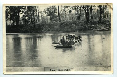
black and white photograph, late 19th century
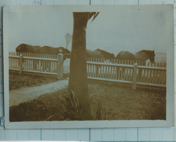
A punt crossed the Snowy River at Orbost from 1884. A bridge was constructed in 1893, but was soon damaged by a huge flood. Flooding was a regular occurrence, the worst inundations being in 1870, 1893, 1925, 1934, 1952 and 1971. Over the years major flood protection works have been implemented. The Princes Highway, which passes Orbost, now crosses the flood plain on raised concrete supports. (info, from Victorian Places Orbost)This item is associated with the Snowy River and its history. It is a pictorial record of transport in the late 19th century.A black / white photograph (copy) of a punt loaded with people and a horse-drawn carriage making its way across a river.on front at bottom - "Snowy River Punt"snowy-river-orbost transport shipping -
 Orbost & District Historical Society
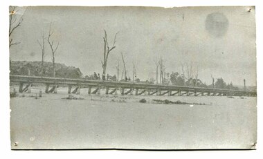
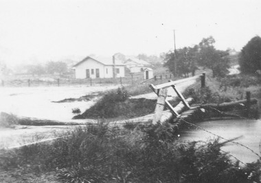
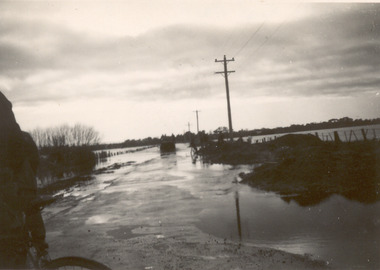
black and white photograph, January 1934
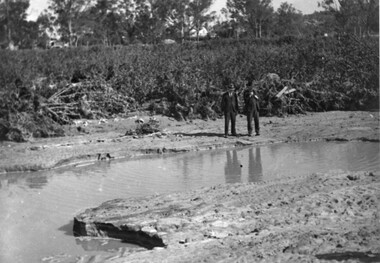
... orbost-flood-1934 railway-viaduct-orbost...-flood-1934 railway-viaduct-orbost A very faded black / white ...Orbost has been subject to major floods throughout its history, such as those which left the town isolated in 1934, 1952, 1971 and 1978. It is recorded that the Snowy River broke its banks and flooded the flats 104 times between 1884 and 1978. Extensive flooding in Eastern Victoria during June 1978, caused widespread damage to roads, road closures and hazards to traffic, particularly over the Queen's Birthday holiday weekend.This is a pictorial record of a significant event in Orbost's history.A very faded black / white photograph of flood water under the railway viaduct at watt's Gulch.orbost-flood-1934 railway-viaduct-orbost -
 Orbost & District Historical Society
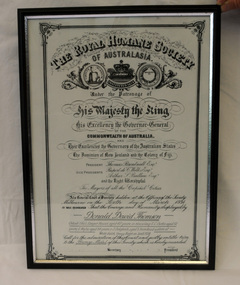
certificate/award, after 1934
... award certificate royal-humane-society flood snowy-river... royal-humane-society flood snowy-river 1934 thomson-david ...This certificate was presented to Donald David Thomson , sleeper hewer, aged 42 years for rescuing S.C. Curtis, aged 52, G. Wylie, aged 54, J. Dalgleish, aged 5 from flood waters at White gulch on the Snowy River on January 8, 1934. (The certificate reads as White's Gulch but should be Watt's gulch.) Although damage estimated at 500,000 pounds was caused by the unprecedented floods along the Snowy River, no lives were lost because of the courageous actions of men like Donald Thomson.A framed copy of a printed and hand-written certificate from the Royal Humane Society of Australia awarded to Donald David Thomson for rescuing victims of the floodwaters in Orbost January 1934. It is dated 6.3.1934.Printed at top of certificate: THE ROYAL HUMANE SOCIETY / OF AUSTRALASIA. Has names of Society patrons and committee as well as names and ages of those rescued. award certificate royal-humane-society flood snowy-river 1934 thomson-david -
 Eltham District Historical Society Inc
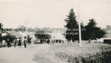
Slide - Photograph, 1934 flood, Eltham South, c.Sep. 1989
... 1934 flood, Eltham South...1934 flood... views. Eltham Diamond Creek (Creek) 1934 flood Eltham South main ...Part of a slide show presentation "Bridges & Waterways of the Shire" by Russell Yeoman to the 13 September 1989 Society meeting. The presentation included slides of historic photos from the Shire of Eltham Pioneers collections as well as several recent views.35mm colour positive transparency (1 of 33) Mount - Agfa CS System grey 8 dotsProcess Date Sep 1989eltham, diamond creek (creek), 1934 flood, eltham south, main road bridge -
 Eltham District Historical Society Inc
Document, Samantha Westbrooke Pty Ltd et al, 2 Bell Street, Eltham: Cultural Heritage Significance Assessment & Heritage Guidelines for Future Use & Development, 2012
... afterwards were impaced by the 1934 Diamond Creek flooding. Guido... afterwards were impaced by the 1934 Diamond Creek flooding. Guido ...Prepared for Nillumbik Shire Council by Samantha Westbrooke Pty Ltd in association with Peter Mills PhD, Architectural Historian and Roark Muhlen-Schilte, Archaeologist. Covers history of early market gardening in Eltham with the commencement of European settlement in the late 1830s. The site for the village of Eltham was surveyed in 1851 and the Township Plan shows that the property is made up of Lots 7 and 8 which were sold at auction in June 1852 to M. O'Shea. The history of the Bell Street property is closely tied to the West family from the 1860s to 1930s; the earliest rate books for Eltham show William West farming in El;tham in 1864. In the aerly 1930s ownership of the creek side was transferred from the west family to the Fabbro family who shortly afterwards were impaced by the 1934 Diamond Creek flooding. Guido Fabbro relocated the original West home further up the hill and built a new Italianate style modern home in situ. The Fabbro family farmed the property. In 1993/4 Eltham Council acquired the creek-side market garden blocks to the south of 2 Bell Street which was recconceived in 1998 as the Barak Bushland Reserve. The Fabbro house was demolished shortly after and the lots were sold to a developer in 1994. The large steel shed now present on the 2 Bell Street property dates from soon after this sale.26 A4 pages color printcultural heritage significance assessment, peter mills, samantha westbrooke pty ltd, shire of nillumbik, 2 bell street, eltham, market gardening, west family, fabbro family, land use, barak bushland reserve, heritage assessment -
 Eltham District Historical Society Inc
Photograph, Heidelberg - River Yarra in flood at Heidelberg, 1934
... Heidelberg - River Yarra in flood at Heidelberg, 1934... Heidelberg - River Yarra in flood at Heidelberg, 1934 Photograph ...Black and white photographCopied by Hugh Fisher, Photographer, 6 York Street Eltham A1679Bfloods, heidelberg, other areas, shire of eltham pioneers photograph collection, yarra river -
 Eltham District Historical Society Inc
Photograph, M. North, Main Road, Eltham near Fitzsimons Lane Roundabout, Dec 1985, 1/12/85
Two colour photographs of Main Road, ElthamSouth between Falkiner Street and Bolton Street at the roundabout of Fitzsimons Lane, Eltham, Dec 1985Noted on 463B 'See 1934 small black and white snap of flooded bridge and the same two shops. This snap taken from same location, Dec 1985. Old Eltham Park on right of photo The two shops at left (Ansel and Muir) Road ahead crosses new bridge over the Diamond Creek, Eltham Main Road now dual highway, through Lower Plenty to this bridge'main road, eltham, eltham south, fitzsimons lane, round about, falkiner street -
 Orbost & District Historical Society
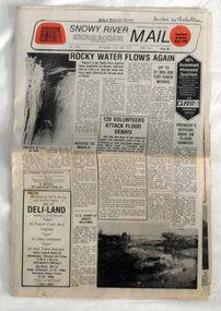
newspaper, Snowy River Mail, June 14 1978
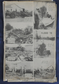
Orbost has been subject to major floods throughout its history, such as those which left the town isolated in 1934, 1952, 1971 and 1978. It is recorded that the Snowy River broke its banks and flooded the flats 104 times between 1884 and 1978. Extensive flooding in Eastern Victoria during June 1978, caused widespread damage to roads, road closures and hazards to traffic, particularly over the Queen's Birthday holiday weekend.Since 1890 the Snowy River Mail has been the local newspaper of the Orbost district.This local paper has been the means by which readers in Orbost were able to learn about newsworthy events and issues in their local community for over a century. This paper is a contemporary record of a significant event in Orbost's history of flooding.A newspaper, Snowy River Mail, which contains black / white photographs of the 1978 floods in Orbost.orbost-floods-1978 -
 Ringwood and District Historical Society
Photograph, Mullum Creek in flood, Ringwood. Adelaide St. Bridge to Reynolds Ave washed away, 1931
... Creek in flood. Adelaide St. Bridge to Reynolds Ave washed away ...Catalogue card reads, "Mullum Creek in flood. Adelaide St. Bridge to Reynolds Ave washed away, 1931". Typed below photograph, "Adelaide St. bridge, to Reynolds Ave washed out in 1931 (Bridge not replaced). 1934?" -
 Ringwood and District Historical Society
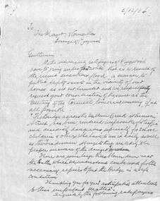
Document, Council flood relief for Mullum Creek flood in Ringwood in 1934
... Council flood relief for Mullum Creek flood in Ringwood in... relief for Mullum Creek flood in Ringwood in 1934 Document ...Hand written letters to Ringwood Council re flood relief.Correspondence to Council from Ratepayers asking for flood relief resulting from the flood damage in the vicinity of Harrison Street bridge over Mullum Creek in 1934. -
 Orbost & District Historical Society
newspaper clippings, June 1978
Orbost has been subject to major floods throughout its history, such as those which left the town isolated in 1934, 1952, 1971 and 1978. It is recorded that the Snowy River broke its banks and flooded the flats 104 times between 1884 and 1978. Extensive flooding in Eastern Victoria during June 1978, caused widespread damage to roads, road closures and hazards to traffic, particularly over the Queen's Birthday holiday weekend. These newspaper articles are contemporary records of a significant event in Orbost history.A collection of black/white newspaper clippings relating to the 1978 flood in Orbost. Some are original articles. others are photo-copies. They appear to be from the Snowy River Mail newspaper.floods-orbost-1978 newspaper-articles -
 Eltham District Historical Society Inc
Photograph, Heidelberg - River Yarra in flood at Heidelberg, 1934, 1934
... Heidelberg - River Yarra in flood at Heidelberg, 1934.... in flood at Heidelberg, 1934. Photograph ...This photo forms part of a collection of photographs gathered by the Shire of Eltham for their centenary project book,"Pioneers and Painters: 100 years of the Shire of Eltham" by Alan Marshall (1971). The collection of over 500 images is held in partnership between Eltham District Historical Society and Yarra Plenty Regional Library (Eltham Library) and is now formally known as the 'The Shire of Eltham Pioneers Photograph Collection.' It is significant in being the first community sourced collection representing the places and people of the Shire's first one hundred years.Digital imagesepp, shire of eltham pioneers photograph collection, other areas, yarra river, floods -
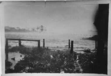
 Inverloch Historical Society
Photograph, 1934 Dec - Pound Creek - tidal floods - pig paddock - side of house - Henderson property
-
 Inverloch Historical Society
000250 - Photograph - 1934 Dec - Pound Creek - tidal floods - pig paddock - Henderson property - E Henderson
-
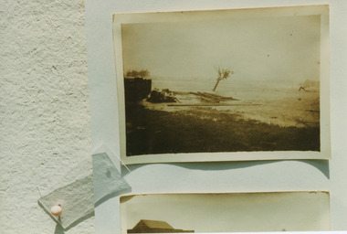 Inverloch Historical Society
000251 - Photograph - 1934 - Pound Creek - Henderson property - floods in front of house - E Henderson
-
 Inverloch Historical Society
000253 - Photograph - 1934 - Pound Creek - Henderson property - floods - water coming around pig paddock side of house - E Henderson
-
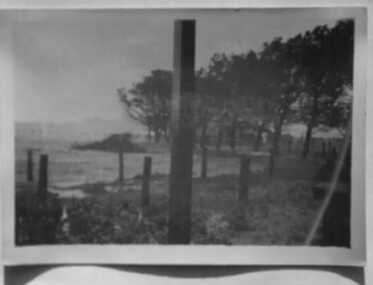
 Inverloch Historical Society
000241 - Photograph - 1934 - Pound Creek - Henderson property - front fence floods - E Henderson
-
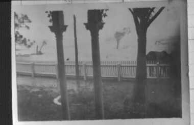
 Inverloch Historical Society
000236 - Photograph - 1934 Dec - Pound Creek - Henderson property - floods at front gate and horses - E Henderson
-
 University of Melbourne, Burnley Campus Archives
Photograph - Black and white print, Flood in Orchard, 1934
... 1934 flood... ellery centenary celebrations orchard tom trahair 1934 flood alex ...This photograph was sent to Burnley in an envelope printed, "On His Majesty's Service" Centenary Celebrations State of Victoria & City of Melbourne 1934-35 Department of Agriculture, Melbourne and handwritten on it "Flood in orchard 1/12/1934 Mr. Jessep." Note by T.H. Kneen 8 April 1992, "Alex Jessep (left) with Tom Trahair. Periodically Tom would take leave to go back to his home town Yackandandah to test a new theory to find the lost gold seam at the Little Waterloo mine."Black and white photograph. George Russ and Frank Ellery examining the ground by the flooded river. Uprooted trees behind them.This photograph was sent to Burnley in an envelope printed, "On His Majesty's Service" Centenary Celebrations State of Victoria & City of Melbourne 1934-35 Department of Agriculture, Melbourne and handwritten on it "Flood in orchard 1/12/1934 Mr. Jessep."george russ, frank ellery, centenary celebrations, orchard, tom trahair, 1934 flood, alex jessep, uprooted trees -
 Inverloch Historical Society
000171 - Photograph - 1934 Dec - Pound Creek - Tidal floods - Nick near stables and Henderson property fence - E Henderson
-
 Kew Historical Society Inc
Photograph - Second Johnston Street Bridge in Flood, 1934
... flood -- 1934... Johnston street bridge bridges - yarra river -- kew (vic.) flood ...Original, small black and white print photograph of crowds lining the Johnston Street Bridge watching the flood waters below. The annotation on the reverse clarifies that Kew is in the distance.Annotated on reverse: "Gift of G.S. Beard / 2nd bridge / Johnston St. Studly Park Rd. Bridge looking towards Kew / 1st bridge 1858–1876, 2nd bridge built (bad bend), 1876–1958, 3rd bridge 1958, lined up Johnston St and Studley Park Rd."johnston street bridge, bridges - yarra river -- kew (vic.), flood -- 1934 -
 Kew Historical Society Inc
Photograph, Floods in North Kew, 1971
Living with natural processes was frequently a challenge to early European settlers and later residents of what was in the 1850s administered by the Borondara Road Board. This was compounded by the area being bounded on three sides by rivers (Yarra River, Koonung Creek and Gardiner's Creek). In 1849, the historian James Bonwick recorded that "our district [Kew] suffered considerably. Mr Wade speaks of 80 acres, out of 100 acres of his cultivated paddock, covered by water." Newspapers continued to describe major flooding in Kew in 1863, 1869, 1878, 1880, 1889, 1891, 1916 and 1934. While the construction of the Upper Yarra dam in 1957 reduced the levels of flowing downstream, local and riverine floods continue.The Kew Historical Society's pictures and map collections testify to the impact of flooding in the district. They have historical importance in documenting the extent of flooding in the district and its affects on homes, services and recreation. Numerous photographs record flooding throughout the Twentieth Century.Floods in North Kew, 1971. Looking northeast towards Kilby Road from River Avenue. Annotation on reverse: map and date "8 Nov. 71 10.30am".floods (kew), yarra river, kew flood, kilby road flood -
 Port Fairy Historical Society Museum and Archives
Photograph
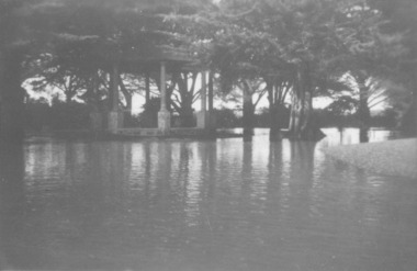
Showing the flood waters of 1946 around the Band Rotunda in the botanical gardens. Funding for the construction of the Rotunda was bequeathed in the Will of local resident Mrs Annie Williams, who was born in Daylesford in 1872 and died in Kew in 1930. Annie’s Will stipulated that the remaining value of her Estate be spent on erecting a Bandstand in the Port Fairy Botanical Gardens dedicated to the memory of her brother Hugh, a stretcher bearer in WW1 and who died in 1921 after being discharged with health issues, her husband Henry, and herself naturally. There is a plaque dedicated to Annie on the Bandstand She requested that the Bandstand be a replica of the one at Daylesford but by 1933 the value of her Estate had diminished to £76.4/8 which was insufficient to cover a similar design and the Borough Councillors felt it would be too extravagant for the Port Fairy Botanical Gardens. Local builder J.J.McLaren’s tender of £71.15/- was accepted and the octagonal concrete pillared construction was completed with the use of sustenance labour the following year. The Bandstand was opened in December, 1934 with a performance by the Port Fairy Band and local residents enjoying the entertainment and a picnic. In 1934 it was reported that there was some fuss in Council because of the whereabouts of the sum of approximately £3/- , being the amount left over from the build. After some months of debate, in which the Councillors suggested that the Engineer had used the money inappropriately, and to which he responded that the build had cost more than the quote, the matter seems to have ended there An image of the flood waters in the botanical gardens in 1946Black and white photograph of Flood water around rotunda in the gardensflood, river, botanical gardens, port fairy, moyne river, rotunda, bandstand -
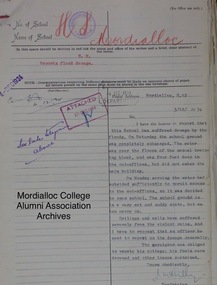 Mordialloc College Alumni Association Inc (MCAA)
Correspondence document, 1934 Flood of the school - correspondence from Headmaster Mr McCully to the Education Department, 03/12/1934
... 1934 Flood of the school - correspondence from Headmaster... Street Aspendale melbourne 1934 Flood of the school ... -
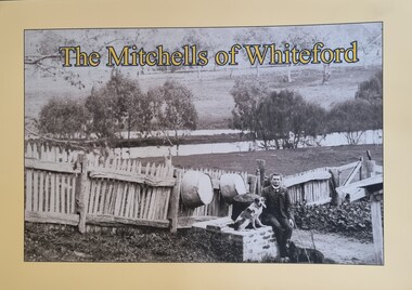 Wodonga & District Historical Society Inc
Book - The Mitchells of Whiteford, Paul Mitchell, 2020
"Whiteford is a mystical place. A small farm in north-east Victoria, rising from the rich flats of the Mitta Mitta River a few kilometres upstream from its confluence with the mighty Murray River. Taken up in 1879 from the large Bethanga run, Whiteford was home to the Mitchell family until it was flooded by the Hume Weir around 1934. Through this collection of family photos and small stories, we might glimpse something of family and farming in the fertile Mitta Mitta Valley before it was flooded by the Hume Weir" - Paul Mitchell, author.A family history of the Mitchell family of Whiteford, Victoria. This publication includes stories and many black and white images of the Mitchell family and their home."Whiteford is a mystical place. A small farm in north-east Victoria, rising from the rich flats of the Mitta Mitta River a few kilometres upstream from its confluence with the mighty Murray River. Taken up in 1879 from the large Bethanga run, Whiteford was home to the Mitchell family until it was flooded by the Hume Weir around 1934. Through this collection of family photos and small stories, we might glimpse something of family and farming in the fertile Mitta Mitta Valley before it was flooded by the Hume Weir" - Paul Mitchell, author.mitta mitta history, mitchell family history, whiteford mitta mitta valley -
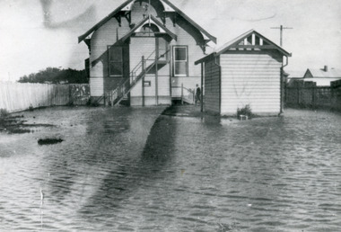 Lakes Entrance Historical Society
Photograph - Floods, 1934
Severe flooding all over Gippsland in August 1934. All low lying areas of Lakes Entrance flooded.Black and white photograph of flood waters around the Mechanics Hall. Shows external stairway to bio-box addition for film projector. Mr Syd Allen projectionist seen at lobby steps. Lakes Entrance VictoriaOn Back Old Cat No 77floods, halls, houses, roads and streets -
 Eltham District Historical Society Inc
Document - Folder, Orford family
... 1934 Flood... Le Pine Funeral Home Life Member Order of Service 1934 Flood ...The Orford family, a pioneer family remained continuously living and working in Eltham for 170 years from 1854 to 2024. James and Sarah Orford arrived in Sydney in 1839 aboard the ship “Orestes”; they had several children there before settling in Eltham in 1854. Three children, James Mathias, Sarah Amelia and Thomas Henry initially remained in the Eltham area. James eventually moved to Brunswick. Sarah married Arthur Butler Young and finally lived in Bunyip. Thomas who was six years old when the family arrived in 1854 remained in Eltham, married Helen Logan who died, leaving a large family. They lived in a slab hut by the Yarra at Laughing Waters and Thomas managed the Panton Park Estate, a selection owned by Magistrate Thomas Panton. Thomas’s son, Ernest Orford was born 1892 at Pitt Street, Eltham and also lived his entire life in Eltham working as a labourer, orchardist and later as a gardener and grounds keeper for Sir William Irvine, a former Chief Justice and Premier of Victoria. Ernest married Kate Thomas; their two sons Ron and Doug stayed in the area. Another of Thomas' sons, Arthur, also lived in Eltham. Four Orford generations attended Eltham schools. Doug Orford was born on the kitchen table (reference, son Ted Orford) of the family home at the corner of Reynolds Road and Mount Pleasant Road. Doug married Gwen and they established a family however Gwen died at a young age from cancer. Doug eventually remarried another Gwen and they lived for several decades in Napoleon Street, Eltham. Doug was actively involved in EDHS over many years, including serving as a committee member and vice president. Contributions by Doug and Gwen (Treasurer/Membership Secretary), his wife, assisted EDHS to continue to develop as a not-for-profit group intent on promoting and preserving our local history. Both Doug and Gwen were made Life Members of EDHS. They also acted as EDHS delegates to the Eastern Region of Historical Societies. His significant work with assisting to establish our valued Local History Centre helped develop our home base and supported the continued growth of our society. Doug’s local knowledge, suggestions and family connections were highly valued, Until recent times, he continued to regularly attend our Collections Team workshops providing his insights and historical information about photographs and society records. Doug died peacefully July 8, 2024, and represents the last link in the Orford Eltham chain which spanned 170 years. His funeral was held Thursday, July 18, 2024, at Le Pine Funerals, 848 Main Road, Eltham. Contents: Typed notes, no date: Memories of Ernest Orford [taped 1979] about his school days. Handwritten notes, no date: History of Ernie Orford Typed notes, no date: History of Thomas Henry Orford and family. Photocopy: Shire of Eltham General Rate Receipts. Received from D Orford 7 June 1923 and Received from E F Orford, 4 August 1924. Letter, no date: Nillumbik Shire to Russell Yeoman, Gwen Orford to receive Volunteer Recognition Award. Newsletter article: "The Orford Family, Eltham", Shire of Eltham Historical Society, No.80 September 1991. History of Orford family. Handwritten notes: 21 March 2011, genealogy of George Orford. On reverse Melways map makred with Orford and other land ownerships. Newspaper advertisement, 21 March 2011: "264 Reynolds Road, South Eltham", property for sale [land in ownership of Orford family]. Letter: St Margaret's Anglican Church Eltham to Doug Orford, 17 November 2011, Extracts from church records relative to Orford family. Newspaper article: "Timely facelift at war memorials', Diamond Valley Leader, 30 April 2024, Nillumbik war memorial will have some work and a bronze plaque will be installed at the Eltham Avenue of Honour, Wingrove Park; photograph of Doug Orford Newsletter item: "Welcome home medal", Eltham District Historical Society newsletter no.216 May 2014, World War I two 'Welcome Home Medals' in ownership of local men, being Harry Gilham and Doug Orford. Order of Service, Le Pine Funerals (Eltham), In Loving Memory of Douglas Frederick Orford 22nd August 1929 - 8th July 2024 Doug Orford Reminiscences (2002) in conjunction with Jock Read and Peter Bassett Smith; 4 pages - 3 typed, 1 handwritten possibly transcribed from an audio tape recording (location unknown). New word file and associated pdf created [\Dropbox\EDHS DATA\DOCUMENTS\COLLECTION CATALOGUE DOCUMENTS AND PDFs\2-2 Family Folders\EDHS_06110-2 Doug Orford reminiscences 2002.docx - 1 April 2025]Newspaper clippings, A4 photocopies, etcdoug orford, harry gilham, welcome home medal, eltham avenue of honour, nillumbik war memorial, wingrove park, henry dendy, alfred armstrong, james orford, 264 reynolds road south eltham, george orford, george joseph orford, maryanne george joseph, thomas henry orford, ernest orford, e f orford, eltham cemetery, helen orford, joseph panton, panton park, gordon lyon, banyule estate heidelberg, james matthias orford, wurundjeri, constable peter lawlor, george hill, franklin street eltham, ronald orford, eltham primary school, john brown, robert gamble school inspector, sarah orford, mary ann orford, james mathias orford, sarah amelia orford, james peet, arthur butler young, watsons creek victoria, kangaroo ground victoria, helen logan, william orford, jane orford, arthur orford, frederick orford, florrie orford, victor orford, chem orford, sunnymede eltham, panton hill estate, sir william irvine, gordon lyons, kate thomas, north eltham gospel church, harold clapp, eltham cricket club, research primary school, dalton street school eltham, keith banks, betty banks, benjamine boyd, laughing waters road eltham, freddie gilsinen, douglas frederick orford, eltham district historical society, funeral service, le pine funeral home, life member, order of service, 1934 flood, 1939 bushfires, alcock & pierce, ansell, associated schools sports, blacksmith shop, boakes, bridge street, bryce family, bullock track, butcher, catholic church, cliff lester, cliffy green, daisy smith, dave lyon, diamond creek, diana bassett smith, dick tooth, dr. frank may, eltham higher elementary school, ernie andrew, fire station, flower stall, fodder business, fruit shop, furniture store, gahan family, garni burges, greensborough, harold norman, harry hawker, hat factory, hawker & owen, hay and com store, henry hawker, henry street, j .harry butherway, jack burgoyne, jack ryan, jock read, john lyon, junk yard, kevin gahan, kilpatricks, len parsons, lyon family, machine factory, mc leans, memorial, metery road, miss reynolds, monteith 's bus, mr. gadd, mrs. bird, mrs. morrison, napoleon street, peter bassett smith, peter's gahan, plenty river, plumridge, produce store, public hall, rechabite hall, reynolds road, roger bird, rutter family, ryan family, shoe factory., staffs produce store, studley cairn gahan, sweeneys lane, swimming pool, taylor street, tennis court, warren family, wooden bridge, yarra brae road -
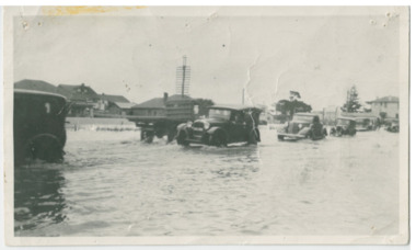 Chelsea & District Historical Society Inc
Photograph - Chelsea Flood December 1934, Point Nepean Road (Nepean Highway)
... Chelsea Flood December 1934... Flood December 1934 ...In December 1934, 700 houses were inundated with water, when the Dandenong Creek and Patterson River broke their banks.Black and white photo of flood waters across Point Nepean Road (now Nepean Highway). Cars and trucks are driving through the water.flood, chelsea, dandenong creek, nepean highway, point nepean road -
 Chelsea & District Historical Society Inc
Photograph - Chelsea Flood December 1934, Wells Road, Chelsea
... Chelsea Flood December 1934... Road, Chelsea Photograph Chelsea Flood December 1934 ...In December 1934, 700 houses were inundated with water, when the Dandenong Creek and Patterson River broke their banks.Three Black and white photo of flood waters across Wells Road, Chelsea. A SEC truck can be see travelling down Wells Road in photo one and two, with people viewing the flooded street.flood, chelsea, dandenong creek, nepean highway, point nepean road -
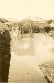 Chelsea & District Historical Society Inc
Photograph - Chelsea Flood December 1934, Carrum Hotel, Nepean Highway
... Chelsea Flood December 1934... Chelsea Flood December 1934 ...In December 1934, 700 houses were inundated with water, when the Dandenong Creek and Patterson River broke their banks.Black and white photo of flood waters in the garden of Carrum Hotel, showing an archway and in the background is a partially built building.flood, chelsea, dandenong creek, nepean highway, point nepean road, carrum hotel