Showing 13808 items matching "golden-gate-bridge"
-
 Marysville & District Historical Society
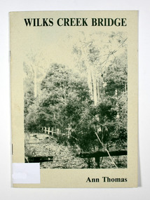
Book, Wilks Creek Bridge, 1993
A history of the Wilks Creek Bridge and its connection to the Yarra TrackPaperback. Front cover has an old photograph of the Wilks Creek Bridge.Dear Reader, The pen has only to select one of the many stages of building old Yarra Track,/ for a colorful story subject. The Track, first established in the early 1860's to/ serve goldseekers making their hazardous way to the rich Wood's Point goldfields,/ extended some 160km from Eltham - in Melbourne's northern region to Woods/ Point in the eastern ranges. I hope a glimmer of the excitement of those times comes through as I draw/ your attention to old Wilks Creek bridge and its picnic spot to be found 3.5km/ west of Marysville. Once part of Yarra Track and now superseded by a modern/ roadway alongside, the old bridge with its solid masonry walls either side of the/ cold, pure stream makes a pleasing scene for the visitor. With much pleasure/ I dedicate this narrative to Marysville and District Historical Society./ Ann Thomas Stamp of Marysville & District / Historical Society Inc / P.O. Box 22 / Marysville 3779wilks creek, marysville, yarra track, victoria, history, local history -
 Buninyong & District Historical Society
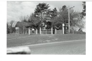
Photograph - Original B/W Photograph, Clive Brooks, Buninyong Botanic Gardens, main gate, Cnr. Scott and Inglis Streets
B/W photo, across intersection to gates on corner of Scott and Inglis Streets, double iron gates with single gates either side, then short length of picket fence. Wire fence down Scott Street to left, wire fence and hedge along Inglis to left. Big Cypress tree centre behind gate, assorted other large trees surrounding.buninyong, botanic gardens, gate, streetscape, trees -
 Surrey Hills Historical Society Collection
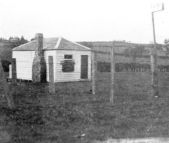
Photograph, The gate-keeper's shed, Surrey Hills Golf Club
Reproduced by permission of Mr John Arnold from his book: "The Riversdale Golf Club - a history, 1892-1977." Copyright to book: Riversdale Golf Club. Surrey Hills Golf Club operated from 1892-1908 then moved and became Riversdale Golf Club. The game was played across paddocks from Trafalgar Street, Mont Albert to Whitehorse Road and down Victoria Crescent to where Box Hill TAFE is now located in Elgar Road. There were problems with cows eating the tee flags! The clubhouse still exists as 30 Trafalgar Street.Apart from it association with the Surrey Hills Golf Club which is long gone, this image documents the landscape of pre-urban Surrey Hills.Black and white photo of a rectangular timber building with a slate hip roof and brick chimney on the LHS. The one visible window appears to be boarded up and has a door to its right. The building is fenced by posts and wire. A (?) street sign bearing the letters FLINT is at the right of the picture."The gate-keeper's shed was used as a clubhouse from 1895-1900."sports grounds, surrey hills golf club, riversdale golf club, timber building, john arnold -
 Stawell Historical Society Inc
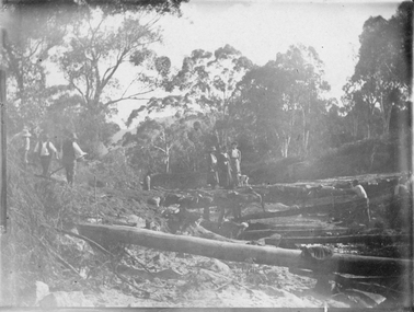
Photograph, Bridge Building -- Possibly Delley's Bridge c1901
Photo of 3 women with a dog standing on a bridge with 5 men possible working on the Bridge in the Grampians. Photo taken in the area where Delley’s Bridge now stands, Hall’s Gap. c1901Sepia Post Card depiction people around a log bridge over a waterway in bush setting.Post Cardstawell -
 Kiewa Valley Historical Society
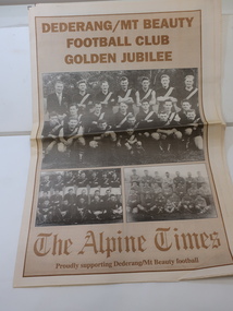
Newspaper Supplement - Dederang/Mt Beauty Football Club, Dederang/Mt Beauty Football Club Golden Jubilee
The Dederang/Mt Beauty Football Club held a golden anniversary reunion at the Dederang Recreation Reserve to celebrate 50 years of football and affiliation with the Tallangatta League. Celebrations also included the Bogong and Tawonga football clubs.The Alpine Times 8 page Special Feature Supplement titled the 'Dederang/Mt Beauty Football Club / Golden Jubilee Celebrations' published July 29, 1998. Includes articles and photos.dederang/mt beauty football club, kiewa valley football, bogong and tawonga football clubs, tallangatta football league -
 Lara RSL Sub Branch
Book, The Golden Years The Royal Australian Air Force 1921-1971, 1971
Department of Air 'The Golden Years', Royal Australian Air Force 1921-1971. A very comprehensive history of the RAAF from 1921. Outstanding photographs both black and white and colourBlue cover paper front and back cover. RAAF insignia on front page with gold writing 'The Golden Years'. Colour and Black and White photographs,log book entry in original handwriting. Appendices 1-5.Nil -
Lara RSL Sub Branch
Photograph, Names of World War 2 Serviceman on the Memorial Gate
Names of World War 2 Serviceman on the Memorial Gate -
 Stawell Historical Society Inc
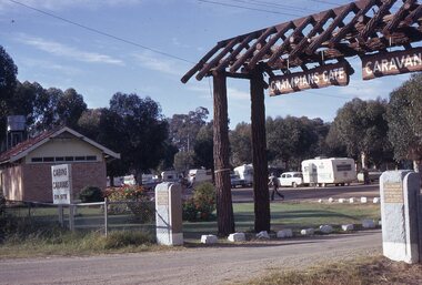
photograph - Slides, Ian McCann, Enterence to Grampians Gate Caravan Park, 1976 - 1984
Coloru Photograph of the enterance to the Grampians Gate Caravan Park -
 Ballarat Heritage Services
Photograph - Photograph - Colour, Clare Gervasoni, Nimon's Bridge, 1999, 04/10/1999
Nimons Bridge was built in 1890, as part of the then Ballarat-Linton railway. The bridge is 17 spans with tall timber piers of four driven piles each, with triple sets of diagonal cross-bracing and walers and a single row of longitudinal horizontal bracing between piers. The spans are of a uniform twenty feet (6.1 metres), originally supported by four 21-inch x 9-inch (535 mm x 230 mm) Kauri timber beams per span, following the standard V.R. design of the period. When the superstructure was rebuilt after the 1953 fire, the timber beams were replaced with two 24-inch (610mm) deep rolled-steel-joists on each span. These are marked 'Lancashire Steel Co., Scotland' and are believed to have been second-hand. The deck of transverse-timber planks is 103.6 metres in length. Overall the bridge has an impressive appearance with its exceptionally tall triple-cross-braced piers creating a 'three-tiered' effect, with the deck 19.2 metres above the Woady Yaloak River. The Ballarat-Skipton line closed in 1985. Nimons Bridge has been recently restored, as part of the Ballarat-Skipton Rail Trail. How is it significant? Nimons Bridge is significant for technical, historic and aesthetic reasons at a State level. Why is it significant? Nimons Bridge is technically significant as Victoria's fourth-tallest timber trestle bridge when built, and as the third-tallest surviving example. It is also the second-largest composite bridge combining traditional timber piers with RSJ spans and a timber deck and falls within a select group of fewer than ten timber railway bridges with horizontal longitudinal bracing between the piers and three sets of double cross-bracing on its tallest piers, creating a visually striking 'three tiered' effect that enhances its viaduct form. Nimons Bridge is historically significant as having served initially the mining community at Linton, then the Western District agricultural area and in later years a kaolin quarry at Pittong. Nimons Bridge is historically significant as a representative of the 'light' branch line methodology that stimulated the explosion of railway construction in Victoria during the 1880s, and provides an interesting contrast with the more solid and vastly more expensive railway viaducts built in similar terrain on Victorian main lines, at Moorabool and Taradale, in the late 1850s. Approached by a deep cutting and high embankment at either end, the bridge represents a very cost-effective late 19th century engineering solution to the characteristic physiography of western Victoria with flat basalt plains intersected by deep wide valleys occasionally subject to severe flooding. Nimons Bridge is aesthetically significant for its visually impressive viaduct form, crossing a deep and steep-sided valley that is part of a rich cultural landscape. Within close proximity of the bridge are mullock dumps, tailings, shaft sites and other relics of the deep-lead alluvial mining era. The bridge is the most visually spectacular timber-trestle rail bridge in Western Victoria and is among the most spectacular timber-trestle rail bridges surviving anywhere in Victoria. It is part of the Ballarat-Skipton Rail Trail. Classified by the National Trust :02/10/2000 (http://vhd.heritagecouncil.vic.gov.au/places/67986)Colour photograph of a log bridge known as Nimon's Bridge.ballarat-linton, nimons bridge, nimon's bridge, log bridge, viaduct, timber-trestle rail bridge -
 Bendigo Historical Society Inc.
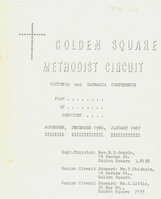
Document - Golden Square Methodist Church, 11/11/1966
Golden Square Methodist Church is situated at 2a Laurel St., Golden Square and was built in 1852. It no longer serves as a church and was sold in 2016.Eight page booklet of the Victoria and Tasmania Conferences, and plan of services. Contains Circuit News and Notes, Plan of Services for divine worship for the Golden Square, specimen Hill, Kangaroo Flat and Lockwood Methodist Churches, financial statements for quarter ending 25th September 1966, and a list of the church officials.religion, lydia chancellor collection, history, church -
 Bendigo Historical Society Inc.
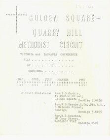
Document - Golden Square Methodist Church Circuit, 01/05/1967
Golden Square Methodist church is situated at 2a Laurel St., Golden Square and was built in 1852. It no longer serves as a church and was sold in 2016.Eight page booklet of the Victoria and Tasmania Conferences, and plan of services. Contains Circuit News and Notes, Plan of Services for divine worship for the Golden Square, specimen Hill, Kangaroo Flat and Lockwood Methodist Churches, financial statements for quarter ending 31 March 1967, and a list of the church officials.religion, lydia chancellor collection, history, church -
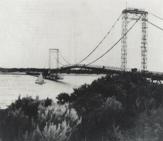
 Phillip Island and District Historical Society Inc.
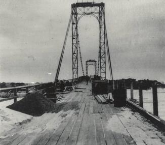
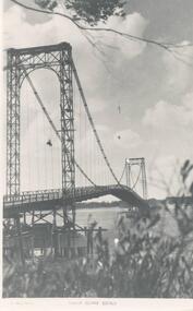
Photograph, Suspension Bridge, 1939 - 40
Suspension Bridge completed in 1940 and opened by Hon. Albert Dunstan MLA, Premier of Victoria. First Phillip Island Bridge under constructionPhillip Island Suspension Bridge taken along length of bridge - under constructionlocal history, photographs, bridges, phillip island - suspension bridge, black & white photograph, jack jenner, phillip island bridges -
 Bendigo Military Museum
Photograph - Army Survey Regiment – Front Gate Guard, Fortuna Villa, Bendigo, c1982
This is a set of four photographs of a front gate guard at the Army Survey Regiment, Bendigo circa 1982. The guard was appointed on a pay day. A Defence decision for a pay rise resulted in a considerable amount of back-dated salary renumerated to members of the unit.This is a set of four photographs of a front gate guard at the Army Survey Regiment, Bendigo circa 1982. The black & white photographs are on 35mm negative film and are part of the Army Survey Regiment’s Collection. The photographs were scanned at 96 dpi. .1) & .2) - Photo, black & white, c1982. L to R: SPR Wayne Lloyd, SPR Steve Linane. .3) - Photo, black & white, c1982. SPR Wayne Lloyd. .4) - Photo, black & white, c1982. SPR Steve Linane..1P to .4P – No personnel are identified. Annotate on film negative sleeve ‘Back Pay Guard’.royal australian survey corps, rasvy, army survey regiment, army svy regt, fortuna, asr -
 Federation University Historical Collection
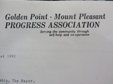
Document - Documents, Documents Relating to the Re-establishment of the Golden Point - Mt Pleasant Progress Association, 1983-1997, 1983-1997
Mara Gluyas was secretary of this organisation for 11 continuous years (1983-1994), and President Ian McKinnon was President for 9 years from 1983-1992). The inaugural 1983 committee was Ian McKinnon, Mara Gluyas, N. Strange, A. Graham, M. Davidson, M. Adams, Peter Hiscock, Ian Blomeley. The Association was concerned with the advancement of the Ballarat area in general and to promote Golden Point - Mt Pleasant area in particular. Small box with purple lid filled with the constitution, minutes associated with the Golden Point - Mt Pleasant Progress Association, and lists of members.mara glouyas, ian mckinnon, sovereign hill, pearce's park rotunda, elms, tree planting, sovereign hill lookout reserve, christmas carols, mine collapse, former golden point direction indicator, signage, norm strange, golden mount historical mines direction indicator, yarrowee creek tree planting committee, peady street, pearce street, barry davis, nerrina tip, ballarat observatory, carols by candlelight, yarrowee park project, magpie street bbq park, neighbourhood watch, magpie street park, cobden street, pryor street bus shelter, hill street, urban wildlife corridor, south street bluestone gutter, eastern baths site, grant street, street lighting, magpie street, letterhead, aboriginal advancement league, golden point primary school, sunnyside woollen mill, ballarat west goldfields, fred hunt, kerry daniell, craig ford, jack colin greville, jack colin greville plaque at mt pleasant lookout, golden point school oval -
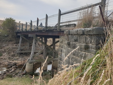
 Linton and District Historical Society Inc
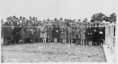
Photograph, Opening of Bridge over Woady Yaloak Creek, between Linton and Scarsdale, 1928, 1928
Black and white photograph of a crowd of men, women and children standing behind a ribbon stretched between sets of bridge rails."Opening of bridge between Linton and Scarsdale".events, bridge openings, woady yaloak creek, faull collection -
 Phillip Island and District Historical Society Inc.
Photograph, Suspension Bridge, 1940's
Phillip Island Suspension Bridge, showing workmen bridge. Bridge completed 1940 and opened by Hon. Albert Dunstan MLA, Premier of Victoria.Phillip Island Suspension Bridge taken from San Remo shoreline with sailing boat underneath and workmen on bridgelocal history, photographs, civil engineering, bridges, phillip island suspension bridge, black & white photograph, jack jenner collection, phillip island bridges, public construction -
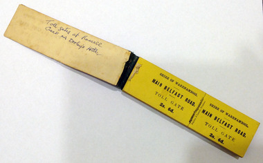 Warrnambool and District Historical Society Inc.
Certificate - Ticket Book, Main Belfast Road Toll, 2s 6d, 1860s
The Shire of Warrnambool operated toll gates from 1866 to 1869 as a means of revenue rai sing for road construction. There were three toll gate locations – on the main Belfast (Port Fairy) Road at Dennington Bridge, on the Woodford Road at Russells Creek and on the Geelong Road at the Allansford Bridge. The toll gates were unpopular and unprofitable for the lessees as travellers were able to avoid the tax by skirting around the gates. They had toll houses besides the gates. The printers of these tickets, Fairfax and Laurie were the lessees at the time of the Warrnambool Examiner newspaper. This paper, founded by Richard Osburne and John Wilkinson, and published with some gaps from 1851 to 1880, is a key source today of Warrnambool’s history at that time. These toll gates tickets are significant because:- 1. They date back to the 1860s and were only issued from 1866 to 1869. 2. They are the only artefacts we hold of the time when toll gates were operating in our local district 3. They are the best example of how the Shire of Warrnambool in its early history raised revenue for road building and maintenance This is a book of toll gate tickets for sale at the Main Belfast (Port Fairy) Road Toll Gate. The tickets (about 50) are yellow and in duplicate with provision to detach the outer ticket for the purchaser to keep. The tickets (two shillings and sixpence) are bound with an adhesive tape and the cover is mottled in pattern (brown and blue). There are also four loose tickets in blue (3 shillings). Back Cover: ‘136’ Tickets in book: ‘Shire of Warrnambool, Main Belfast Road, Toll Gate 2s 6d., Fairfax and Laurie, Printers’ Loose tickets: ‘Shire of Warrnambool, Main Belfast Road, Toll Gate, 3s.’ shire of warrnambool, toll gates -
 Ballarat Heritage Services
Painting, Clare Gervasoni, Old Bridge over the Woady Yallock River, 26/03/2023
Colour photographs of an old timber topped bridge crossing the Woady Yalloak River on Golden Lake Road. The bridge has bluestone foundations. bridge, woady yallock river, golden lake road, bluestone -
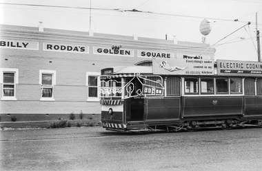 Eltham District Historical Society Inc
Photograph, Bendigo Tramways No. 7 en route to Golden Square on High Street near the intersection of Maple Street, Golden Square, January 1972, Jan 1972
Billy Rodda's Golden Square Hotel now known as the Golden Square HotelDigital TIFF file Scan of 35mm Ilford FP3 black and white negative transparencybendigo, bendigo tramways no. 7, billy rodda's golden square hotel, eaglehawk, george coop collection, golden square, high street, maple street, tram -
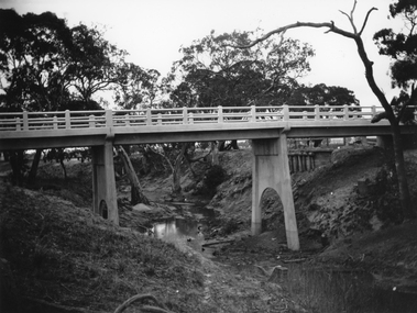 Stawell Historical Society Inc
Photograph, Greens Creek Bridge on the Wimmera River 1929
Greens Creek Bridge on the Wimmera River built in 1929 by C.R.B. and now demolished. The replacement bridge was designed to cope with the floods and the approaches to the new bridge were built up. This photo is a copy of a negative owned by the society.Black and white photograph of a concrete road bridge over a creek. Red gum trees in the background. Two concrete supports remain of old bridge on bank behind new bridge.stawell -
Uniting Church Archives - Synod of Victoria
Photograph, Eleana Miller at Rolland house gate
Presumably originally a deaconess, but not now (2017) listed by that name in the UCA Synod of Vic/Tas directory.Photograph of Eleana Miller entering Rolland House, standing at the gateEleana Miller (on back).miller, eleana -
 Nillumbik Shire Council
Print (lithograph): Alice Blanch CHEHOVSKI, Alice B. (Blanch) Chehovski, Dunmoochin, Gate 1, Printed 2004
Alice Blanch Chehovski was born in Queensland to a Russian mother and Polish father. When her father died leaving three small children to bring up on her own, her Mother took them back to Russia to visit her own parents. In the following fateful year, Stalin came into power and the family was trapped by Russia closing its borders. At the age of twenty three, 1944, Alice entered Moscow's Institute of Decorative Arts and Applied Arts to study ceramics. Neither the subject of ceramics nor the academic drawing in fine pencil inspired her. At that time Moscow was surrounded by German troops, Russian culture was inhibited by the war and generally speaking it was not the time for arts. Alice said 'My soul and my hands were needed as a volunteer, to help the wounded soldiers survive'. Alice struggled through a lifetime of hardship and triumph before returning to her native land of Australia in 1981 at the age of 60. This lithographic print is one of a set of ten produced at Dunmoochin.Lithographic print in black and white depicting Gate # 1 at Dunmoochin. Bottom left of print: ed. no. '4/10' and work title. Bottom right of print: artist signature 'Alice Blanch '04'chehovski, dunmoochin, pugh, gate 1, lithograph -
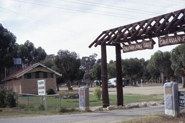 Stawell Historical Society Inc
photograph - Slides, Ian McCann, Grampians Gate Enterance, 1976 - 1984
Colour Photograph showing the entrance to the Grampians Gate Caravan Park -
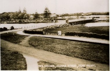 Port Fairy Historical Society Museum and Archives
Postcard, Valentine Publishing Co, The Bridge Moyne River Pt Fairy, 10.04.1929
Black and white Photograph of the bridge crossing the Moyne river with Gipps street in the foreground cleared land in the background taken for use as a postcardThe Bridge Moyne River Pt Fairymoyne bridge circa 1930, bridge, moyne river, river, road -
![The Fairfield Bridge [circa 1891]](/media/collectors/550653872162f11fb04854aa/items/579eab98d0cdd117c4af1c89/item-media/579eac23d0cdd117c4afb1ad/item-fit-380x285.jpg) Kew Historical Society Inc
Kew Historical Society IncPrint, The Fairfield Bridge [circa 1891], c. 1891
This work forms part of the collection assembled by the historian Dorothy Rogers, that was donated to the Kew Historical Society by her son John Rogers in 2015. The manuscripts, photographs, maps, and documents were sourced by her from both family and local collections or produced as references for her print publications. Many were directly used by Rogers in writing ‘Lovely Old Homes of Kew’ (1961) and 'A History of Kew' (1973), or the numerous articles on local history that she produced for suburban newspapers. Most of the photographs in the collection include detailed annotations in her hand. The Rogers Collection provides a comprehensive insight into the working habits of a historian in the 1960s and 1970s. Together it forms the largest privately-donated collection within the archives of the Kew Historical Society.A reproduction of a photograph of the Fairfield Bridge. The bridge was one of the first constructed for the Outer Circle Railway in 1891. Its supervising engineer was [Sir] John Monash. The bridge was later to be repurposed as a road linking the Chandler Highway to Fairfield."Outer Circle Railway Bridge over River Yarra at Fairfield (last section of line opened 1891)"fairfield bridge, chandler highway bridge, dorothy rogers, john monash, outer circle railway -
 Phillip Island and District Historical Society Inc.
Photograph, Suspension Bridge, 1940's
Donated by John JanssonBlack & White photograph of the San Remo to Newhaven Bridge taken from San Remo in foreground to Newhaven in background."Photo Shop Series" "Phillip Island Bridge"phillip island bridge, john jansson -
 Port of Echuca
Photograph, Original photo c.1920
The iron bridge was completed in 1878 and was used by the Deniliquin and Moama Railway company for goods trains only - it was another year before passengers were included in the transport service. On 4 March 1879 citizens of Echuca and Moama stormed the bridge, opened the gates and declared it open for their use.At the turn of the century the railway line carried produce from southern New South Wales & the Riverina to Melbourne, with goods trains being a very important mode to transport. When the bridge was being constructed, six workmen were killed and another maimed when a pile on the Moama bank collapsed. After the storming of the bridge by local people in March 1879 it was declared open for use of local residents traveling between the towns of Echuca and Moama. The bridge was shared by rail, road and pedestrian traffic.An image of the iron bridge at Echuca, taken looking East from Victoria bank.Verso: "Iron bridge"murray river bridge , echuca, murray bridge, echuca, iron bridge, echuca -
 Lakes Entrance Historical Society
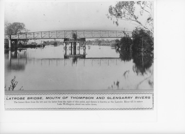
Photograph, Caire, Nicholas John, Swing Bridge Sale Victoria, 1905c
turning on a central axis to allow the passage of river vessels. Image shows machinery for operation and the bridge closed to river traffic. Latrobe Wharf on the left bank is seen through bridge. Sale VictoriaBlack and white photograph of the Latrobe Bridge. This was a swing bridge over the Latrobe Riverbridges, waterways, civil engineering, jetties -
 Ringwood and District Historical Society
Photograph, Mullum Mullum Creek new bridge work commences. Warrandyte Road, Ringwood - 1986
Start of new bridge, Warrandyte Rd. Ringwood 1986 (2 views)Written on back of photograph, "Start of new bridge, Warrandyte Rd. 1986." -
Mount Evelyn History Group
Book Blamire Young, Golden Press, The Art of Blamire Young, 1983
Watercolourist William Blamire Young (1862-1935) was a local artist. His property Mutamaro was on the corner of Swansea and Edinburgh Roads Montrose, diagonally opposite the Mt Evelyn side. He lived there from 1923 till his death in 1935. Young is perhaps best known as the designer of the first Australian-themed stamp (kangaroo on map of Australia, issued 1913). Biography of the artist and a representative collection of his work.Hard cover book, glossy white dust jacket with painting of the Sydney Harbor Bridge by Blamire Young.Noneblamire young, artist, watercolour, montrose, australian stamp